


woodchips
-
Posts
250 -
Joined
-
Last visited
Content Type
Profiles
Forums
Events
Posts posted by woodchips
-
-
You can approach Cathedral Peak from the Chewuch river as well. It's a lot shorter drive than from the tonasket side. (It's about 30 - 45min north of Winthrop.) We did it last year via andrews creek about this time, and saw very little snow, and few people. One of my favorite trips. Ever.
-
I have a WM Apache 15 deg bag I'm looking to sell. I realize this is probably warmer than you want, but if you're interested, send me a PM.
-
The upside to this is fewer crowds on the coleman glacier side. We were up there yesterday, and saw no one on the CD. It's about four miles and 2000' from the washout to the trailhead, and bikeable nearly to the trailhead. Another week and you should be able to bike all the way.
-
As of mon the tree can be bypassed by 4wd. large piles of slide debris have to be negotiated 1/2 mile from the trail head untill the trail enters the trees. A skin track on the south side of the creek with a log crossing at the trail head offers easy travel, but is threatend by cornices and multiple avy paths.
So, are you saying that you can drive to the trailhead in a 4wd?
Does anyone know when the construction starts up there?
-
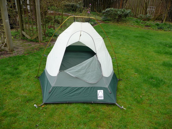
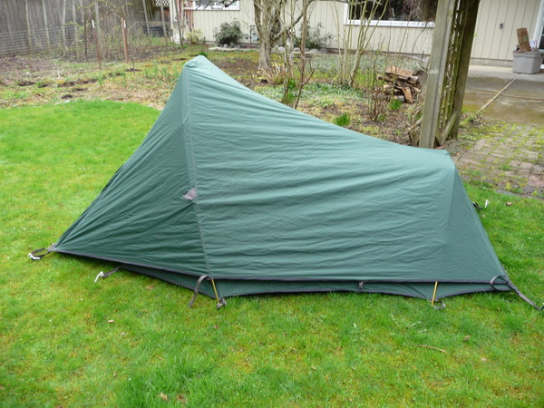
I've got a Sierra Designs Eclipse CD two person tent. It is used, but everything is in great shape; no holes, but netting, floor, poles and zippers all are in fine shape. Totally waterproof. If you're not familiar with this tent, it is a two person end loading tent. It's plenty of room for two, but the tent does get lower towards the feet, so it's not a spacious as some styles of tents. This is a solidly built tent, and should last for years to come. This comes with a stuff sack and 6 stakes.
The tent and stuff sack weigh 3 lbs, 15.5 oz on my scale, and is pretty damn compact when stuffed.
Not sure what this is worth? $75? Feel free to email with any questions. I've also got more pics if needed.
[img:center]http://cascadeclimbers.com/plab/data/516/medium/P1040193.JPG[/img]
[img:center]http://cascadeclimbers.com/plab/data/516/medium/P1040194.JPG[/img]
[img:center]http://cascadeclimbers.com/plab/data/516/medium/P1040198.JPG[/img]
-
Not sure if this is what you're looking for, but I've definitely seen tents in the area above bagley creek, very near the ski area (park at the upper lodge for this). It's FS land, so I don't think there's an issue with it. You might check with ski patrol up there so you don't get run over with a snow cat or anything. They're really friendly, and would likely point you to a good spot.
-
Grant,
The NWAC site is the standard for forecasts around here; however, as the forecasts tend to cover all of western washington, the canadian forecast for the south coast of BC can be just as useful since Baker is so close to the border. Also, check www.turns-all-year.com for trip reports. Definitely the place that gets the most current reports, and is often cited on the NWAC site.
-
I'm open to offers. Do I hear $85?
-
Any feedback on the new edition of the Red Beckey Guide? What's different? Worth checking out? I've got the 2nd edition, but of the beckey guides, it's the one I use the most, so wondering if I'm missing out without the new one.
-
-
How about this stuff?: "climbing equipment" for sale on craigslist.
Sounds like they don't know what they've got, didn't post a pic, and ask for "cash only". It's on whidbey. Anyone lose anything at Erie?
-
I've got a pair of la sportiva Mythos shoes (size 42.5) which I've worn twice before I figured out that I need a half size smaller. They show a little scuffing on the soles, but other than that, they're in great shape. I've even still got the box. They're $130 new, so how about $95? Or, on the off chance that someone else made the same mistake, anyone have a pair of 42s they want to trade?
-
Thanks, Tony
The question marks are a bit troublesome, but the terrain there doesn't look bad. That map is great! May spur some ideas for more adventures.
-
As of sunday (3/8), The road is plowed to the 8 mile marker (there's a campground there, dont remember the name.) Looks like people had continued to drive up the unplowed road from there (3 or 4 inches of snow.) Not sure how much further you can drive, but you can get to the Lookout Mt./ Monogram lake trailhead.
-
I'm interested in doing this traverse, as well. My thought is to start at Diablo, head out stetattle ridge, climb W Mcmillan, and exit Goodell Creek. We're thinking of either the W ridge or N face of Mcmillan; any thoughts on the feasibility of getting around either the N or S side of Mcmillan to the base of these routes?
-
I just talked to the county, and they said they THINK it's plowed to the seven mile marker.
-
Thanks, Matt. I think the monogram lake trail is at about 5 mi, so we might be OK.
-
Anyone been up the Cascade river road lately? Thinking of checking out little devil/ teebone ridge and wondering how close we can get to the monogram lake trailhead.
-
Sale pending on hexes and boots. Other stuff still available.
-
Thanks for all the suggestions. Two questions:
On a route where you only need one tool, would you just take a light alpine axe with a hammer? I've got a CAMP alpax It seems like a good tool for this, but I've never really used the hammer bit.
What specific sizes would be the most useful? The smallest ones of all three styles (lost arrows, knifblades, and angles?) Or stick with a few sizes of one style?
-
I'm interested in getting a handful of pitons for alpine wandering. I'm thinking of places where small chocks may not work, or small frozen cracks.
On easy alpine climbs that are off the beaten path, I usually take a few nuts, maybe a few hexes, always my pink tricam. Occasionally it seems like a piton might be just the thing, but wondering where to start. I've never placed pins before; any suggestions on where to start?
-
I've got a set of hexes; check out this thread
-
Skis and Headlamp sold.
-
sale pending on skis.
Mt Baker - Road to Coleman closed for the season
in Access Issues
Posted
Biked/skinned it about a month ago. It's not bad. It's probably a total of 6 miles from the "official" parking to the washout. We were trying for a car to car trip, which made for a pretty long day, even though we turned around at Pumice ridge due to weather.