

Ptown_Climber1
-
Posts
135 -
Joined
-
Last visited
Content Type
Profiles
Forums
Events
Posts posted by Ptown_Climber1
-
-
Really enjoyed this, thanks, and great work!! I want to get back up there; maybe next weekend....so do you top out near the top of Wy East, is that right?
-
Trip: Mt. Adams 8/22/13 - South Spur
Date: 8/23/2013
Trip Report:
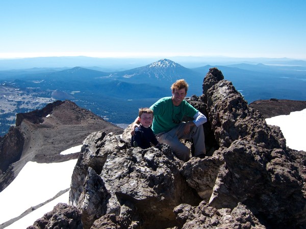
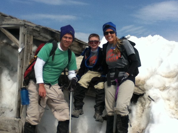
I wouldn't ordinarily post a report about a South Side Adams climb, but this one was notable.....Three years ago my boy summited South Sister at 6 years old, here:
Yesterday the little rascal topped out on Mt. Adams, his first time using an axe and crampons....couldn't be prouder of him. The snow just below Pikers was pretty icy, so he got some real nice practice on some semi-steep terrain, I hadn't totally expected, but he did awesome.
The conditions got squirrly on us on the descent....a system blew in fast, complete with wind, blowing snow, then rain, but fortunately we made it back down to Lunch Counter merely soggy, and with nothing but great stories to tell.
And no, I hadn't planned to wear the exact same thing, three years apart...yikes. Oh well, whatever works....
-
Just saw this thread...sorry it didn't work out for you! Shasta is a beautiful, gentle, giant of a mountain. It's my favorite of the Cascades, and I've climbed most of 'em.
Rainier is a great challenge, but Shasta, if you get off the Avy Gulch, isn't to be underestimated. And there are some cool glaciers on it as well....the Whitney, for one. Hotlum and Bolam as well.... I'm with you on the skiing thing....enjoy the quiet and the solitude....no rush. Hope you're able to get up there next year...I'm planning to climb Casaval Ridge in Winter or Spring, but wouldn't recommend that as your first ascent.....good luck!
-
Wow....yeah that looks quite a bit different than it was for us! Can't blame ya for taking the trail route that day....
So I think this is one of the few pics we took with Mt. Russell in it...Iceberg Lake in the foreground.
-
Thanks!
Yeah, those pinnacles are something to see....I was really impressed by the beauty down there. We didn't see too much trash, although my eco-conscious cousin ended up packing out someone else's blue bag....ewwww, but more power to him.
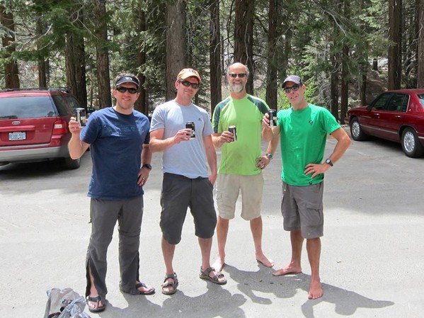
Unfortunately we didn't have enough time to hang out at the Portal Store there and get one of those famed burgers and beers...had to make it back to Reno in time for flight. Enjoyed a nice cold beer in the parking lot though.
No, next time different boots for sure!

-
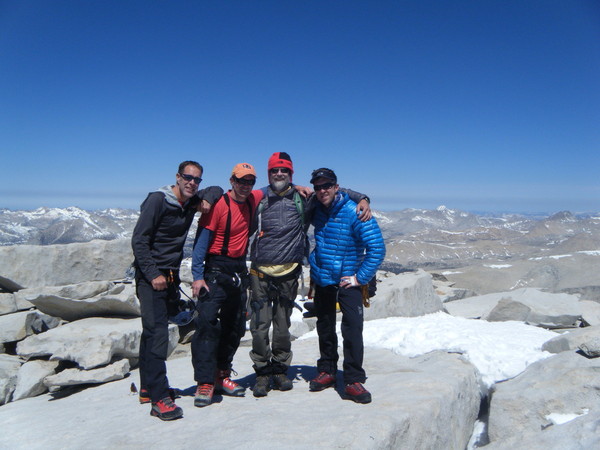
Trip: Mt. Whitney - Mountaineers Route
Date: 5/26/2013
Trip Report:
Well, we finally knocked off the Mountaineers Route on Whitney –something I’d desired for years. But living in Portland, there just never seemed the right time to make it happen. It’s not exactly the easiest place to get to either. But I figured that any route that can claim its first ascendant to be none other than John Muir himself, must be worth the trouble….and it was.
We flew out of Portland EARLY Friday morning to Reno, NV. My cousin Buck picked us up and headed south down the eastern edge of the Sierras. The weather was warm and dry; a nice contrast from the cool rain inundating the northwest these days. Highway 395 cuts a lonely path through a mix of high desert plateau, alfalfa fields, and even volcanic calderas, all the while stopping here and there in cities that bleed historical small town charm: Big Pine, Independence, Lee Vining, Bishop, and ultimately Lone Pine. It is there that, after hours of driving and anticipation, we stop to pick up our permits. The visitors center there is newish and impressive- the staff friendly and helpful, surely a good omen. After picking up our permits, we head up Whitney Portal Road to our destination.
The parking lot is pretty full; it is Memorial Day weekend, after all. But most of these people are headed up the mule, err, main trail. After packing up our 50-60 pound packs we take a quick snapshot and are off. We share the main Whitney trail for about a mile or so before branching off at the junction with North Lone Pine Creek. The main trail turns left…we head right, and the climbing begins. The elevation gain is abrupt. The trail snakes its way through shady pine forest before peaking out into granite-cluttered hillsides, staying close to the creek, while edging closer and closer to the famed Ebersbacher Ledges.
Accessing the ledges wasn’t too difficult; I’d spent way too much time studying this route on more climbing sites than I care to count. Once we hit the lone pine at the familiar spot it became pretty intuitive. Some exposure, but nothing too crazy. We did however initially start out a little low on our traverse back towards Lower Boy Scout Lake…..a friendly German day- hiker yelled at us from below, “You’re TOO low! Too low!” We adjusted and bushwhacked our way higher. This recalculating of route became a frequent routine…
After a seemingly endless trudge through granite ensconced trail steps, we cross the North Fork Creek again, in a calmer state. The lake loomed before us, cradled by the upper slopes of rugged Mt. Whitney, in view for the first time.
We set up camp, eat some tasty ravioli courtesy of Buck and his favorite Oakland Italian joint, and even enjoy some fresh bread and cabernet….we be living the high life here in the high Sierra! And for dessert….a few snorts of Centenario Anejo tequila….
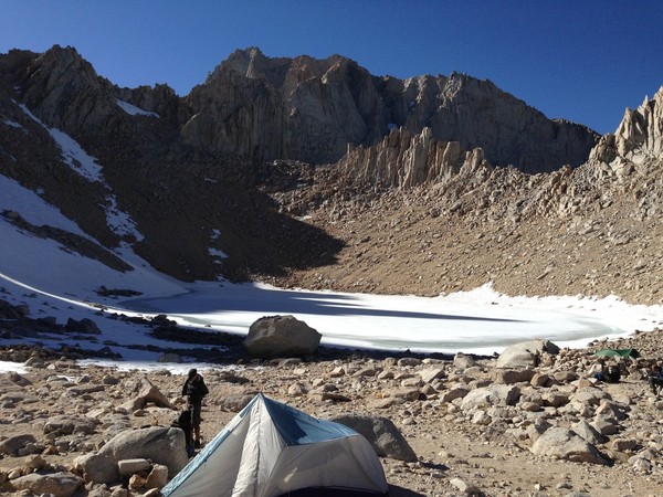
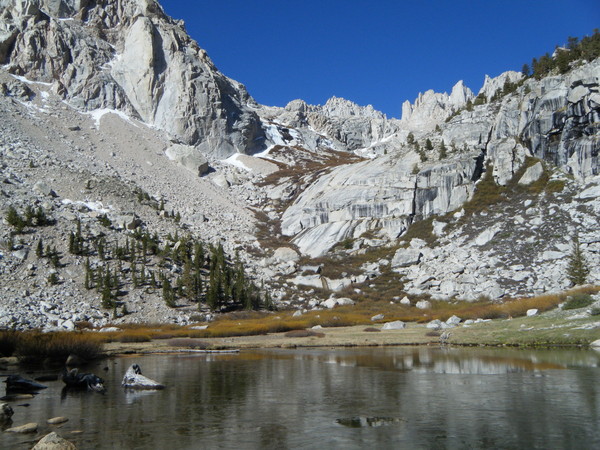
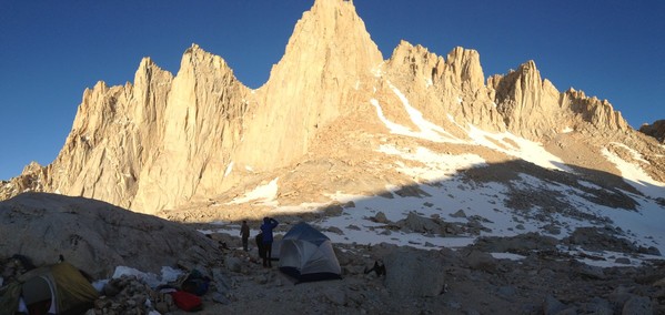
The next morning, after coffee and mediocre egg breakfast, we begin what becomes a common routine for us….packing up camp, and moving on. Today it’s up…but how high? That is the question. We were undecided on camping either at Upper Boy Scout Lake or Iceberg (12,400 feet). Our packs were heavy, so the idea of camping lower at Upper Boy Scout was enticing. In the end though we decided that the advantages of reaching Iceberg Lake were many; primarily because of the prime position it would put us in on summit day, being a mere 2,000 feet from the summit. We slowly leave the pine trees behind, and are greeted by the sound of rushing water cascading its way down the granite domes separating the lakes.
Our only problem was navigating our way to Iceberg proper. The ‘trail’ is mostly clear, until the end. The rock cairns are fewer and farther between, and before we know it, we’re climbing up 3rd class boulder walls in trying to mount ourselves on the lake’s basin. Ultimately we do it the hard way, and there in front of us, on this late Saturday afternoon is Iceberg Lake- the final outpost before the true climb begins.
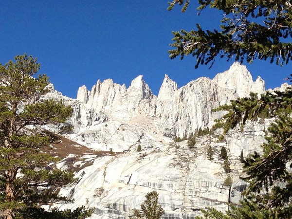
At Iceberg we enjoy meeting and talking with some of the other climbers around. One in particular, an Irish guy from San Francisco, is leading a small group up the East Face. As he’s pointing out his route to us, described as one of the top 10 climbs in America, I start feeling a bit humbled. If that dude is climbing THAT, then we ought to be able to handle the cute little mountaineers route, right? I am curious how his climb went; I know the next day he intended to climb Mt. Russell and the Fish Hook Arete or some other…perhaps if he is reading this, he can chime in.
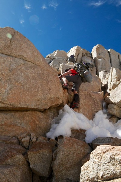
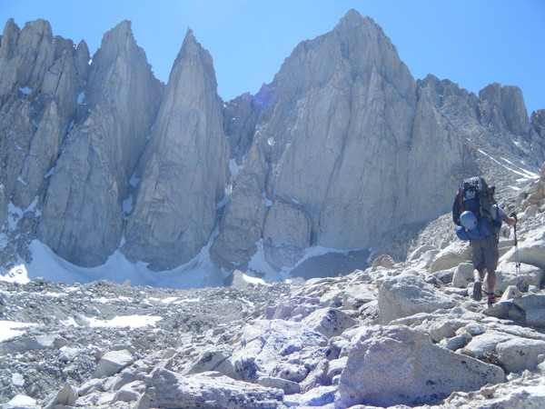
We awaken at the relatively late hour of 6 in the morning. Typically I like to get more of an alpine start, but we’re not in the Cascades; the rock isn’t that rotten volcanic rubble….plus the snow is going to be firm either way going up, and I sure don’t want a piece of the climb above the notch in the dark. After some tea/coffee and oatmeal, we make our way towards the mountaineers gully. I am thrilled to finally slap on some crampons and hear that familiar metallic creak of steel on firm ice and snow….the ice axe at my side, we soon find our rhythm. There’s a guided group on the mountain this day….the clients are from New York and Florida….two of them are in blue jeans, and looking miserable. For the life of me I don’t know why they are there. Not sure what the guide service was thinking on that one…dollar signs I guess. One thing I do know is that I don’t want to be below them in that narrow rock and snow gully.
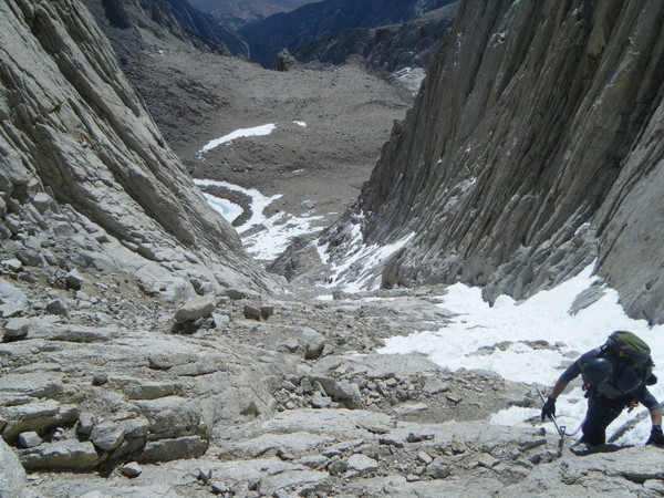
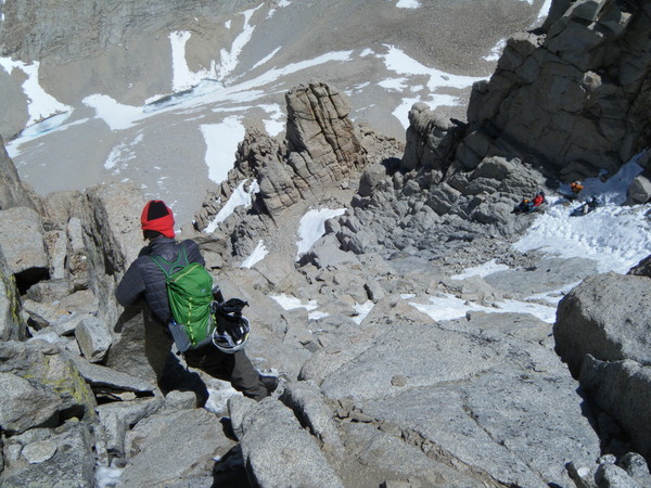
Eventually we top out of the gully and reach the famed ‘notch’ at 14,100 feet. Here is where they say the ‘technical climbing’ begins. I don’t know…we take a look at it and the exposure doesn’t seem too bad, and the climb looks pretty straightforward. I guess it’s all a matter of perspective. My rock-loving chums were pretty comfortable with it. I was in plastic boots more appropriate for our snow-clad volcanoes to the north, and they weren’t the best for climbing rock ledges. In the end though we all reached the summit in our own way, and were met by calm winds, blue skies, and a view that only mountaineers can know.
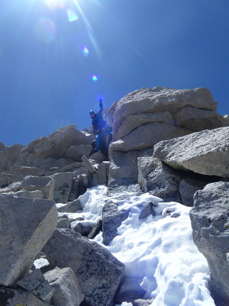
A small throng of hikers that had come up the trail route meandered about the stone summit hut at the top….we make our way there, make some small talk, give some high fives, and take some pictures. In my mind I can’t really relax until I get back down, but I force myself to take a break, and enjoy this special place we’d worked so hard to get to.
One woman looks at us and says to me, “Wow, it looks like you guys worked a lot harder to get here than we did.” Probably so, probably so, I think to myself.
I look to the north and to the south….the mighty Sierras’ jagged peaks scratch at the sky for as far as one can see. It’s been three days since I stood upon Whitney’s summit, but I’m still smiling…. In climbing it I left a part of myself on that mountain, but I think we all took home some memories that will last a lifetime.
Thanks, Dean, Rich, and Buck, for being great climbing partners...let's do it again soon!
-
Wow, awesome pics! And to think I bailed out on Cooper Spur Friday night cause of high freezing level. Looks better than I would of expected! Thanks for sharing...
and I learned a new word: clustfuckery...
-
Friday night.....Cooper Spur.....
-
I'm heading up tonight...already got the day off work tomorrow, so might as well. I think it should start clearing up tonight.....at least I keep telling myself that! Will report back tomorrow.
-
That is really helpful.....Yeah, we'll be prepared for snow/ice, etc....how's the climb above the notch? Ice screws or anything like that necessary? Seems like everyone has their own different take on it.
Love the picture (s)...that's gonna get me through another afternoon at work.
The permit situation has me a little worried, but hopefully the MR in May is still not overly populated. Flying from PDX, what's best airport? Ontario looks like it to me unless I'm missing something....
-
Thanks....I'll do that!
-
A couple of Portlanders here wanting to get down and climb the Mountaineers Route on Whitney in May.....does anyone know the permit requirements/protocol for that? Is it the same process for the trail ascent? I thought I heard somewhere that it was.... Thanks in advance!
-
Nice! Thanks for sharing...nice lunchtime distraction for me at work today.
-
I think Saturday was a totally different deal.....we were at hogsback before sunrise this morning and there was already shit coming down.....but you're right....it always amazes me how many people will be coming up late in the day.....
-
I was up there today too, and while the weather was beautiful, the heat inversion was a disaster for climbing....icefall was horrendous and unsafe.....everyone I saw was turning around....we tried to skirt up low above hot rocks, but retreated....way too dangerous. A guy near us got tagged and had to be helped off the mountain.
Are you speaking of a different day perhaps? Cause today was really sketchy up high in my opinion......
-
I'm heading up there tonight......freezing level is high....am hoping it stays at freezing or below at least by hogsback....will check it out anyhow....
-
Nice....looks good. I'll be heading up Sunday night if anyone's interested in hooking up....drop me a message.
-
Awesome pictures and report....enjoyed that, thanks.
-
Trip: Mt. Baker - Coleman-Deming
Date: 8/7/2012
Trip Report:
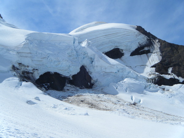
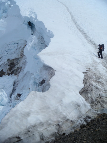
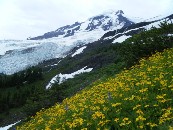
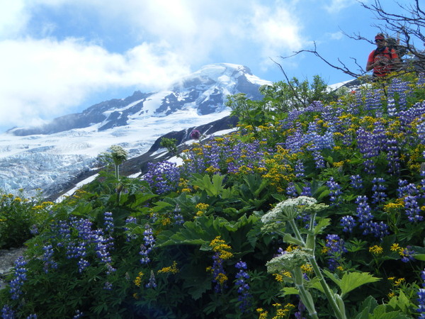
I'm a little late getting this trip report out, but felt this climb certainly warranted one.....Rich, Dean, and I had Baker on our list for quite some time, but living in Portland, it's quite a haul to get up there (essentially 6 hours). But now having done it, I'm kicking myself for not getting up there sooner. Baker, it turns out, is the total package: short on the carnival crowds that overrun Rainier and Hood, stunning high alpine scenery with glaciers that for a moment make one forget about global warming, a rainbow cloak of wildflowers, and a climbing experience that is challenging, diverse, and exhilarating. Now I understand why people come from all over to climb it. We met fellow climbers from near and far...most from Canada...some from Europe even.
We left Portland early on Monday morning, with hopes of getting to the trailhead by a little after lunchtime...mission accomplished there. After a quick lunch in the parking lot we hoisted onto our backs about 50 pounds or so of gear and were off. Before going a hundred yards we learned that the bridge over the river is out, so the first of a few precarious river crossings across logs and wet rocks was in order. Fortunately these all went off without incident.
The lower trail is akin to hiking through a Hawaiian rainforest-different vegetation of course-but similar. The rain did indeed drizzle down on us, but nothing too substantial. After about 2.5 miles we got our first view of the mountain and its vast glaciers. Awe-inspiring.
Soon we reached the hogsback, not to be confused with our hogsback on Hood of course....this one is still part of the dry trail and reminiscent of a scene from The Sound of Music....here we first see endless fields of wildflowers that, with the lower, serac-addled glacier in the background, make for quite a sight. Cameras cannot do this justice.......Above the hogsback we reach high camp. There is an abundance of bivys available, and in fact that first night we were the ONLY ones on the mountain.
The sky cleared out, and after a surprisingly tasty dinner of shepard's pie cooked up by Rich, we enjoyed sipping some anejo tequila as the sun set out over the Puget Sound. Life, I was reminded, is beautiful, and while I'm not a church going guy, watching the alpenglow display on Baker on a summer night is a spiritual experience if there ever was one.
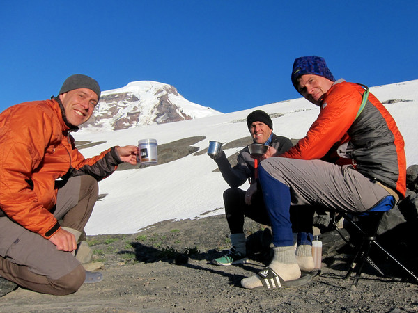
We awaken at 3:00 for our summit climb....after some rustling around and the inevitable question that ALWAYS goes through my mind in that dark, cold tent, "Why do I do this?", we emerge. Eat some bad oatmeal, rummage in the dark as we strap on those pickets, harnesses, etc....mice dart this way and that between the rocks.........The climb begins.
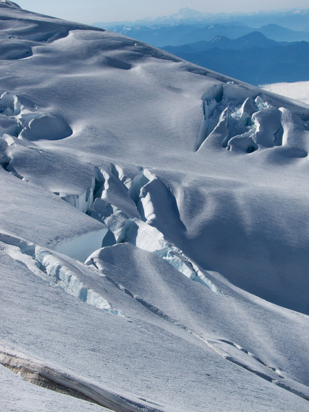
Right out of the gates we are on a fairly steep snowfield, passing crevasses that at the time seem big, but as we learn later, these are merely cute compared to the man-eating behemoths yet to come on the upper glacier. The morning is a crisp and clear one...wind is minimal. One couldn't ask for much better....the sound of crampons cutting into the snow, the clank of an ice axe, and your own breathing....it all becomes part of a background symphony...a soundtrack for contemplation, personal thoughts, and sometimes just plain 'spacing out'. But upwards we go.
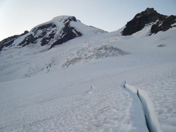
Soon we reach the 'football field'....an open, flatter part of the glacier that is criscrossed with smaller crevasses, almost like yard lines. But it becomes apparent then, that even after an hour of glacier-trudging, our end zone is well above us, and truly not even yet visible......The climb becomes real though at this point as we traverse diagonally up through the glacier, beneath ice cliffs, between massive crevasses that seem to come out of nowhere, and through debris fields that no doubt are reminders that things do indeed fall down here, and we had better not be there when they do....keep moving, keep moving....sometimes too much thinking isn't a good thing.
After what seems like an eternity we reach the saddle between Baker's summit mass and Colfax Peak to its west. It's a place called the Pumice Ridge, but that seems way too nice a name. Really it's a 300 yard, knee grinding, mind-numbing and discouraging scramble on loose volcanic rubble and dirt...no step a solid one, as your crampons squeak and grind over rock. A redeeming factor is an overwhelming and impressive view now of the Deming Glacier to the south as you straddle this rocky ridge between two of the peak's most massive and signature glaciers. The crevasses below us are haunting.
Eventually though we do regain the steep snowfield which serves like a ramp up to the summit caldera.
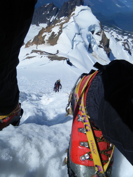 It's steep, and the run out isn't a good one, but there is a clear boot path all the way up....the adrenalin is welling up now as we can smell the summit, both figuratively and literally....the scent of sulphur is in the air. Again, after what seems like forever, we turn the corner at the top and are greeted by the great domed summit mass.....and wind that nearly knocks you over. Ahhh....we're here, right? Nope....because anyone who has climbed a bunch of Cascade volcanos knows, they seem to enjoy taunting you with false summits...no, the true summit is all the way over THERE....that sad looking mole-hill at the far southeast side. We make our way there...I hit the deck...thrilled to be at the top a new mountain....it's 11:05 AM. The Mazamas register box creaks heavily open....after signing the register, and a few requisite summit shots we are off. I really can't relax until we get back down off the glacier...
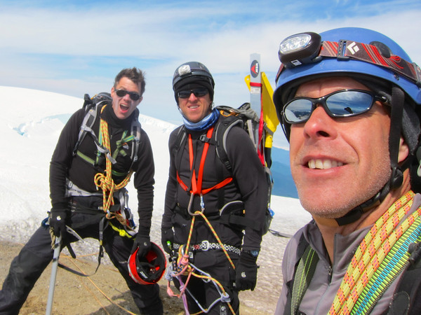
But we're smiling inside and out...I've climbed a lot of mountains, and I hate to rank them....but Mt. Baker has got to be near the top....I look forward to going back some day.
Kris
Portland, OR
Gear Notes:
rope, pickets, standard glacier travel/crevasse rescue gear
Approach Notes:
Bridge is out....3-4 river crossings, but not too difficult....a couple snowbridges, but still in good shape...many crevasses you can work around or jump over...
-
My group climbed Coleman-Deming a few days ago, and also thought the route was in fantastic shape. Was curious about how Easton Glacier route compares to it; may have to try that one next time. Nice job!
Any pics?
-
Thanks Ptown! Did you summit via the Coleman-Deming route?
I'm wondering about how difficult navigating/crossing the Coleman would be late in the season, to gain access to the N Ridge ...
Yeah, we summited via Coleman-Deming....very scenic....I'm not sure about the North Ridge, but it seems like the glacier is really opening up fast...it could get dicey by late August or Sept....good luck though. I loved it up there!
-
Was up there yesterday...route up the Coleman is in great shape still....we pretty much had the route to ourselves....Some big holes, but you can mostly go around them.
-
Well, I wish I would of stayed home too......the climb up to Hogs was beautiful, and snow was firm and icy.....don't think I've seen that bad of icefall in the crater though in a long while. Was Saturday morning better?
-
Whoa, dude....you took some serious chances, unless conditions actually got colder than they were when I got to Hogsback at 4:30 AM Sunday morning. Freezing level way too high...
When I got up there it was a continuous thundering of icefall in all directions....I think most opted out. Glad you made it out of there safely....
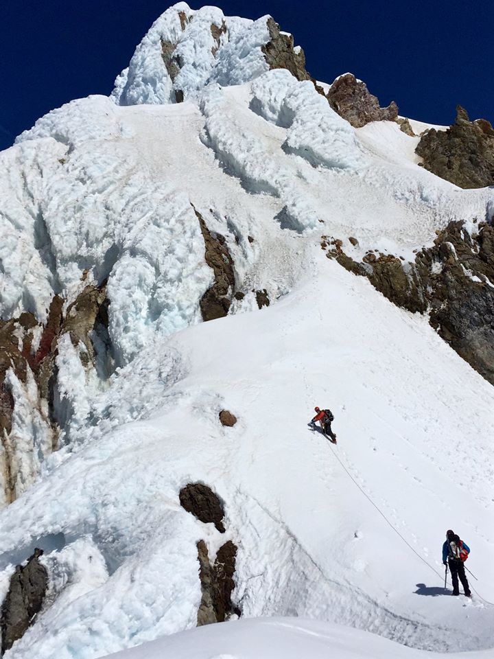
[TR] Mt. Hood - Reid Glacier Headwall 1/5/2014
in Oregon Cascades
Posted
Yup....climb Hood enough times, and 'close calls' with ice or rock fall are inevitable. I had a near miss with a basketball sized chunk of rock that had sloughed off Crater Rock above me as I traversed back to Illumination Saddle. Will never forget the sickening sound it made as it whizzed by me.....twas a widow-maker for sure....