


Coastal_Climber
-
Posts
9 -
Joined
-
Last visited
Coastal_Climber's Achievements
")
Gumby (1/14)
0
Reputation
-
Below is the information describing the rap route on Sir Donald, it was sent out in the MCR (Mountain Conditions Report) to all climbers that subscribe to it. I haven't done this route myself but a good friend of mine was witness to an accident on the route last summer that took the life of a Washington State climber. The Rap route may be faster but use caution, I also heard there is only room for two climbers at most rap stations. Here is the accident report, also from the MCR "Synopsis: A party of two climbers from Washington had reached the summit of Sir Donald, via the NW Ridge and West Face Bi-Pass to the summit. One of the climbers was beginning the fourth rappel. This is a steep rappel. By staying to the north side of the ridge, one can rappel to easier ground, and a short down climb to the next anchor. If one rappels off the south side, it becomes overhanging, and difficult to get back onto the ridge proper. The rope being used was an 8mm x 50m twin rope. Knots were not tied in the ends. Prussiks were not being used. The rappel device was a standard ATC. The climber on rappel was on the south side of the ridge, which is overhanging. She was not able to swing over to the ridge proper, and was unable to stop her descent, due to the lack of friction provided by the ATC on the 8mm rope. With no knots at the end of the ropes and no back-up prussik, there was nothing to prevent her from sliding off the end of the rappel rope. She fell approximately 300 meters." ------------------------------------------------------------------------------------------------------ Mount Sir Donald - Descent Route On Friday September 6, 2002 Jordy Shepherd and Eric Dafoe bolted the west face dihedral descent route on Sir Donald, as well as a portion of the steeper ridge above the dihedral. Thanks to the Lake Louise Warden Service for the use of their gas powered gun (R.I.P.). There are ten 2-bolt stations, at 25m intervals (one 50m rope required). Each station has 2 Fixe hangers with the integral steel rap rings. On September 3, 2003 Jordy Shepherd and Ken Bibby climbed the NW ridge and descended the summit bypass and the bolted rappel route. We cut off a schwack of old rappel slings, on the way up and down, leaving the best slings in place. We had reports of climbers having difficulty finding the bolt stations, so we recycled some of the old slings as streamers off the bolts at each station. They are now highly visible. The streamers are straight tied so as to avoid the mistake of clipping into the old tat instead of the obvious burly steel rings! All of the stations have red or other colors of webbing streamers, except at station #5, which is yellow to denote the change in rappel direction, where the rappel line turns off the ridge and down the slabby west face. On August 14, 2004 Jordy Shepherd bolted two additional rappel stations at the very bottom of the rappel route, on the white slab at the base of the dihedral, above the final scree slope that is above the approach trail. They are marked with webbing streamers. Here are the rappels (stations are numbered 1-12 from top to bottom): 1. The fastest way off now (dependent upon conditions) is from the summit down the south ridge, dropping off the ridge down the west face and back to the NW ridge to bypass the summit block. This route can be snowcovered in early season and may require and ice axe and crampons. Easy down climbing leads to some rappels on sling stations. Some more downclimbing leads to where the ridge steepens again. The first bolt station is here, right on the ridge. Rappel 25m along ridge to station #2. 2. Rappel ridge 25m to easy down climbing. Down climb a short ways along the ridge to where it steepens (station #3). 3. Rappel 25m along ridge to station #4. 4. Rappel staying a few metres on the north side of the ridge, to the top of the dihedral corner/slab. The rappel continues down the slab and skier's right slightly to station #5 (25m). Ignore the sling station at the base of the steep wall on the north side of the ridge as the bolt station is further down onto the slab at the 25m mark. 5. Rap at 25m intervals, station to station for six 25m rappels. The stations are slightly offset to reduce rockfall exposure when pulling the rope. Rappel towards scree and the base of a narrow gully in the slab that is on the skier's right. Ignore numerous webbing stations that are to both sides of the rappel line. The rappels end at the base of the gully, on scree. 6. From station #9 rappel on a trend to skier's right to hit station #10. From station #10 rappel again to skier's right to hit dirt at the base of the gulley. You have now done 10 rappels. 7. Scramble down easy scree and ledges to rock slab/snow at the base of the dihedral. Rappel two more stations (rappel # 11 is a full 25 metres, and rappel # 12 is 15 metres) or downclimb (4th class) a combination of rock slab and snow (amount of each is dependent upon time of season) to easy scree slopes and the trail that cuts across the scree and snowpatches on the approach to the Uto-Sir Donald Col. This route basically follows the lower of the two proposed rappel routes drawn on the bottom photo of page 104 in David Jones' Selkirks South. See attached photos. The red line denotes the bolted rappel line. Photos and the route description for both the Sir Donald rap line and the Deville headwall rappel line are available for viewing at the visitors centre at Rogers Pass. On Sept 5, 2003 Parks put a single barrel green throne style outhouse and a metal double garbage can for food/gear storage in the Sir Donald / Uto Col. There is a green outhouse and food/gear storage at the bivy site in basin below the Sir Donald / Uto Col as well. As of August 14, 2004, Parks has added a piece of trail that cuts from the upper Vaux Creek crossing, around the base of the steep morraine into the Uto/Sir Donald Basin, and up to the lower bivy site. There is a toilet and food/gear storage there now. Some flagging tape and cairns mark the new trail. There is also a rough trail cairned and grubbed, that climbs from the lower bivy site to the original approach trail that takes you to the col. This new trail conveniently hits the original trail where you come down off the rappel route. So it is now reasonable to hike up to the lower bivy site, camp, then climb the NW ridge the next day without leaving anything at the col, then take the rappel route to descend, and return to your gear at the lower bivy, then take the new trail down to Vaux creek. A nice round trip. On September 1, 2003 Jordy Shepherd placed new summit registers on Fox, Selwyn, Hasler, Feuz, Sir Donald, Uto, Eagle, Avalanche, and Hermit. Macdonald and Tupper also received new summit registers in summer 2003.
-
[TR] Grainger- South Ridge 7/2/2006
Coastal_Climber replied to Ponzini's topic in British Columbia/Canada
Your welcome. Let me know when you want to climb Nursery. -
I am the person that organized the trip to the N twin. First of all I didn't know that it was "illegal" to have this many people, 14 in a group in the mountains. Now that I know this I feel that I must contact the authorities to inform them that I encountered a party of eighty climbers in a solid group heading for the summit of Mt Rainier, this definitely "ruined our parties experience" Our party on the N Twin had no "accidents", although an independent party of four on the S Twin ran into trouble and required assistance. I don't think a large party increases the risk of an accident. Unless your referring to roped climbing, where I agree 2-4 people max. As for the impact on the environment. The first three hours of our day were cycling on logging roads, fairly low impact. The last time I was there I encountered a large group of "good old boy's" on oversized quads, I think they wreck the road more than bicycles. Then we hiked through a "clear-cut" hope we didn't impact that to much. There was a trail that we hiked on for fifteen minutes, fourteen people may have been to many, I think two groups of seven would have been better. Once we were on the ridge our party broke up into smaller groups and we couldn't even see each other. Not exactly a mob scene. In short there were no meadows to tromp, trails to trash, campsites to overload AND we were the only party to climb the N Twin on that day. I think it's a good thing that the road is gated, as this being such a classic scramble it probably would look like Rainier if the access was easier. I will however try to keep the group size to 10-12 people in the future, I believe this is the number the "authorities" want to see. It's the number I wanted to see, but due to the deteriorating weather some people bailed on their overnight trips and came on mine (which meant less people on Shuksan) I hope this puts this to rest.
-
Oh I'm pretty sure I saw it here, where else would I find something that twisted? But hey I could be wrong, I'm sure someone must have seen it somewhere.
-
OK it's like this. It starts off by saying that there is a picture below of a fallen climber with his insides on the outside and that it should not be veiwed. When you scroll down there is a picture of a bunch of eggs with faces and climbing gear drawn on them. They are standing in shock around a broken (climber)egg with it's yolk spilled out. The picture is followed by "your sick you looked" Ya I know, I could have taken my own photo and made this myself by now, but I really want to find it. I know I seen it here about 6-8 months ago.
-
I'm trying to find an old thread. It's where there is a warning of a picture of climber hurt in a fall, and when you scroll down it's a broken egg. I can't find it with the search tool.
-
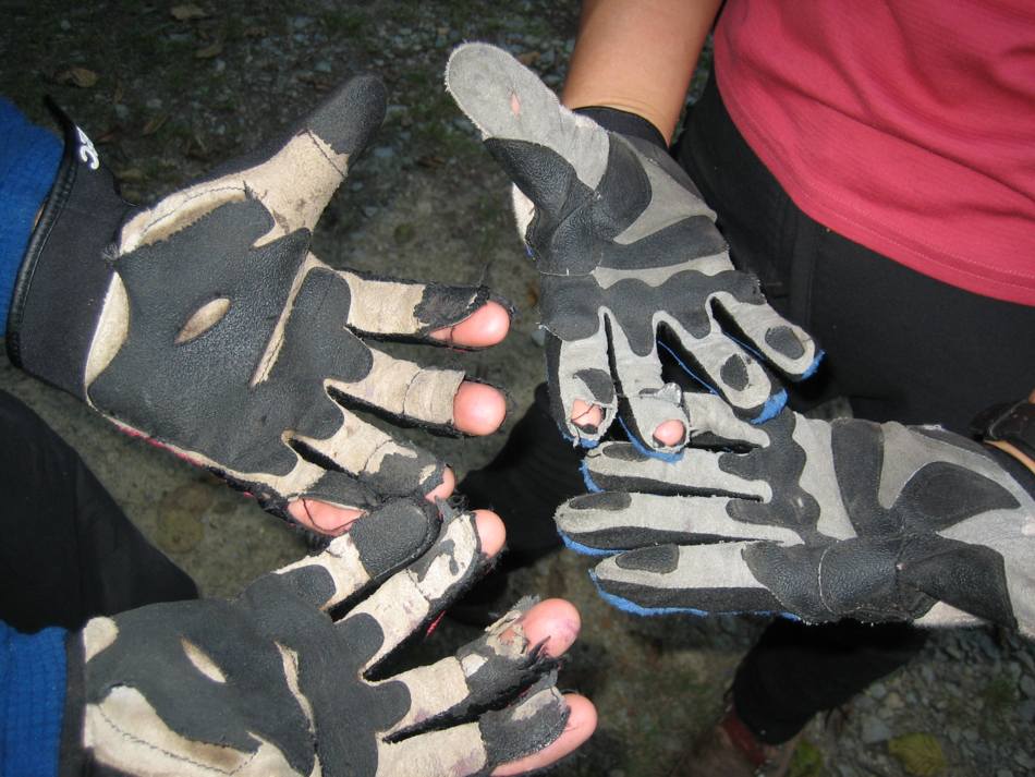
After a day on the N Twin. Mine on the left, Luwayo's on the right.
-
Is that the same pair you blew the button off of on the N Twin? It's a good thing I had a safety pin or you would have been
-
Well it's nice to know our flagging is still there. We went in on the Easter weekend in 2003 to scope the route to the water platform so we wouldn't have to mess around to much when we came back in August. But the fire closure of the backcountry killed that plan and I haven't been back yet. I also cleared a path with my loppers as well, but I'm sure it's grown back in by now. It wasn't that hard to find our way to the water platform and I had planned on removing the Flagging as I received a little criticism for doing so.