TeleRoss
-
Posts
688 -
Joined
-
Last visited
Everything posted by TeleRoss
-

first descent [TR] Degenhardt - Degenhardt Glacier 6/28/2004
TeleRoss posted a topic in North Cascades
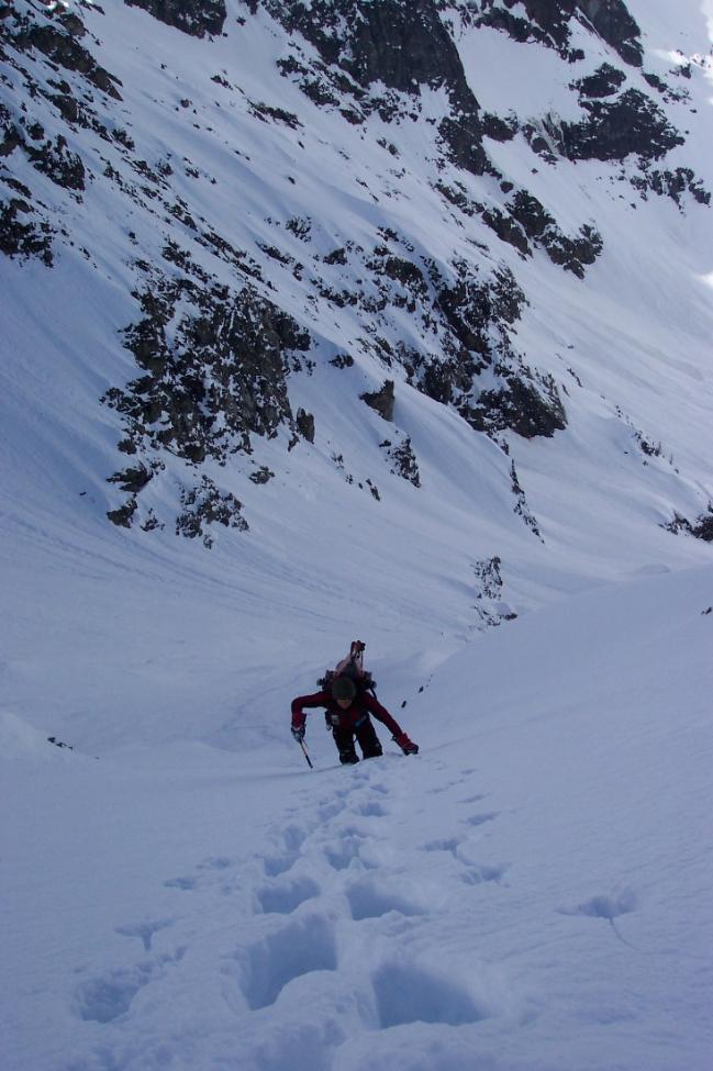
Climb: Degenhardt -Degenhardt Glacier Date of Climb: 6/28/2004 Trip Report: Sky and myself climbed and skied the Degenhardt Glacier along with a couple other lines in the southern Pickets on Monday 6/28. After suicidal avalanche conditions forced a turn around last week, plans were quickly made for a return trip to the southern Pickets. Sky and I left Seattle Sunday morning and were at the Goodell Creek group camp mid morning. We left the car shortly after 11. Good trail leads to ~ 1/2 mile short of Terror Creek. There we followed climbers path(s) to a log crossing at Terror Creek at 2,100'. On the north side of the creek we were able to follow a faint climbers path nearly to the top of the ridge. The previous week we spent many hours schwacking around on the lower areas of the ridge and dealing with many cliffy areas. This time though we found the path that trends up a gully near the log crossing. This way was waaaay easier. We topped out on the ridge near 3700' and made our way up to ~5400' where we made camp. Total time to camp: 7+ hours. Sunday we climbed to the pass near the Chopping Block and skied down into Crescent Creek basin. We traveresed the basin to near the bottom of the couloir that leads up to West Terror Col (Terror-Rake Col). Climbed nearly 800' to the col. We had been advised that this may not be the best way to get down into MacMillan Cirque as the slope on the North side of the col may be super steep. Upon reaching the col and peering over the north side we did find a steep slope, but one that was skiable. The first several hundred feet were real steep and then the angle eased back some and it was super cruiser. We skied down for nearly 2000' until we could traverse below the North Buttress of Mt Terror. At ~5400' we put skis back on the packs and roped up as we accessed the Degenhardt Glacier. We daddled around for a little trying to find a way up through the icefalls in the lower sections of the glacier, and eventually ended up climbing pretty much directly through after Sky found a little hidden line up through some ice blocks. The angle eases some in the middle sections of the glacier before coming to a steep 1500' headwall. there were some large crevasses but none that blocked the route completely. We climbed the steep headwall on the eastern portion. We topped out on the col between Degenhardt and the Pyramid. The ski down was spectacular. Conditions were ideal and the setting amazing. We skied our climbing line on the eastern side of the glacier and down to the icefall. At the icefall the ski line was blocked and we rapped ~100' down the icefall. From there we traversed back below the North Buttress of Terror and climbed the 2000' back up to the Terror Rake Col. We skied the couloir back down the south side of the col into Crescent Creek basin and bivvied just beyond the mouth of the couloir. Tuesday we had a leisurely morning and hiked back out the way we came. I've got some pics, but my camera went tits up on me during the trip, Sky should have some pics up on his site soon. Gear Notes: 30m rope 30m cord pickets used em for the rap Approach Notes: Goodell Creek Follow the climbers paths and it's not too bad...miss the paths and it can be heinous -
Yeah, Colin that was me and Sky that skied the Degenhardt. It was freakin awesome! We crossed at the Terror Col, and skied that line down into MacMillan Cirque. You were right, it was pretty steep up at the top. Then climbed and skied the Degenhardt. finished it off with a cool little 100' rapp over the icefall at the bottom of the glacier. We'll put up a TR as soon as Sky gets his slides back. My digital camera went tits up on me so I don't really have anything good as far as pics go but I think Sky's got the goods. Weird we didn't see you at some point. We must have crossed paths at some point. We bivied Monday night in Crescent Basin just below the Couloir that leads up to Terror Col. Nice work on the N Butt. Looks like a sweet route.
-
Here's a link to a few of my pics... They really don't show much but oh well. I would imagine that someone who has climbed up around Colchuck Balanced Rock would have a great view of the whole couloir? ~Ross http://www.villagephotos.com/pubbrowse.asp?selected=857500
-
In it's current condition, we would have been doing 2 raps through the runnels. That section has really gone fast. As I was skinning towards the NE Couloir the previous week, it sure looked like there was a lot more snow and ice in the runnels.
-
Climb: Dragontail-TC Date of Climb: 4/9/2004 Trip Report: Well, Jason and I decided to return to Dragontail this week, again hoping to climb and ski the TC. We left Seattle at what is becoming the accustomed time of 11:30, and after stops for coffee and goodies, found ourselves parked on Mountaineer Creek Rd. very near the Lake Caroline TH. Quickly skinned up the 1 mi. of road to the end, and by 6:30 we were lounging at Colchuck Lake. We hung out at the lake for a good while, at this time we figured time was not going to be an issue... All the while at the lake the ice was busy popping and creaking and generally sounding very sketchy, so we opted to ski around the lake to access the route. We arrived at the bottom of the hidden couloir, put skis on the packs, geared up and finally started climbing shortly after 9. We climbed the hidden couloir in about half an hour to the base of the runnels where we began belayed climbing. I led the first pitch and stayed to the far climbers right up the runnels. There was some very thin ice encountered on this pitch. Climbed a full 60m pitch to make a belay just beyond the crux section. Jason followed and led the second 60m pitch up a steep snow patch and through a narrow constriction, which with skis on the packs made for some interesting maneuvering, as we had to climb straight up while leaning to the left so our skis would clear a rock. These two pitches put us at the base of the second couloir. Looking back now, we should have either simuled the couloir or just both soloed, but we continued climbing on belay. This is where we began to really eat away at our time. It took us what seemed like forever to get to the rock step separating the second and third couloirs. This section provided some nice mixed moves and put us at the base of the third couloir. A couple more pitches put us at the top, and a quick traverse and 50' or so of climbing put us on the summit...but holy crap is was like 5:30....man we took our sweet ass time. We bailed on the idea of skiing the couloirs, as we did not want to be skiing out in the dark, and decided instead to ski out via Asgaard Pass. We hauled ass out to the car and made it from the summit to the car in less than 2.5 hours. But alas, our two trips to Dragontail TC has resulted in a no climb-no ski trip and now a climb but no-ski trip. Maybe with the TC the third time's a charm? ~Ross Here's a link to some pics: http://www.villagephotos.com/pubbrowse.asp?selected=849073 Gear Notes: 2 60m ropes pitons, pickets, and 1 microcam Approach Notes: trail is melting out fast, road should be drivable to the end shortly
-
The steepest sections of the couloir were probably 50-55 with some sections 55+. Near the top, I was loosing lots of ground with each turn. As far as the rock, I'm not too sure. It didn't look difficult. I'll try to get some pics up tonight hopefully. ~Ross
-
Sam, the couloir is super narrow at the top, enough so that putting my skis on was a sketchy endeavor. My tips and tails were skittering on the granite on the sides of the couloir..interesting position for sure. On the descent the couloir is variable with some really narrow spots and some where it widens a bit. A really nice line, and with the conditions, I really had to be on top of things....super fun.. So how was the traverse you guys did this weekend? ~Ross
-
should have some pics up sometime soon... ~Ross
-
Climb: Dragontail-NE Couloir Date of Climb: 4/3/2004 Trip Report: Climb and ski of NE Couloir on Dragontail Peak on Sat. 4/3. This trip began with the objective of the TCs. We left the car on Mountaineer Creek Rd at ~2:15am. Skinned up the road and trail to reach Colchuck Lake just after 6. This is where the Tom Foolery began. We were leisurely hanging around eating snacks, looking up the route and watching a party of three just beginning the ascent of the hidden couloir. Everything was perfect. So we were ready to head down and across the lake to the route. We were on a small little knoll and coming off of it my climbing partner biffed it good and one of his skis sliced a nice fat gash across the bridge of his nose, and gave himself a mild concussion to boot. Complaining of a raging throbbing in his head and dealing with his bloodied nose and severely bruised ego, we attended to stopping the bleeding and figuring out what these antics had done to our plan for the day. My partner informed me he was done for the day, but that he was willing to hang out by the lake for a few hours if I wanted to climb something. I made sure that he was ok with that, before turning my attention to what it was that I would do. I settled on the NE Couloir on Dragontail, not exactly what we had come for, but at least it was something. So I set off across the lake. And skinned up the slopes below Asgaard Pass, past the hidden couloir, and up to the NE Couloir. There I put on crampons and strapped skis to the pack and began up the couloir. The climbing was straightforeward. Steep snow with the occassional icy section. One short mixed step provided some entertaining stemming and hooking moves, and then on to the upper sections of the couloir which became quite steep. Beckey says the couloir steepens to 40 deg. but it is definitely much steeper than that. Having just been on the NF of Maude and the NE Couloir on Maude, the upper section of the NE Couloir on Dragontail was steeper that any portion of those other routes. Anyway, I climbed to the end of the snowfilled couloir, and stopped there as there was no more skiing to be had on the rock pitches above. Some precarious balancing was needed to remove crampons and put on the skis, and then it was time to ski. The ski was a mixed bag of nice somewhat firm snow, loose sluffy stuff and pretty solid ice. The couloir is steep and winds quite a bit as it descends the face. It was a cool descent in somewhat difficult conditions. Skied out back across the lake to my partner who was now not only sporting his nice gash, but a pretty killer sunburn from the nap he took out in the sun. The mountains sure had their way with him today. I'm sure he'll be eager to get back up there for another round....hopefully with a much better outcome. ~Ross
-
[TR] Mt Maude- North Face and North East Couloir 3/22/2004
TeleRoss replied to TeleRoss's topic in North Cascades
The North Face starts out pretty moderate, maybe 40-45, but steepens to 50+ for the last several hundred vertical feet. The NE Couloir was definitely steeper and more sustained than the North Face route. The NE Couloir was probably somewhere near 50-55 for the entire route. ~Ross -
[TR] Mt Maude- North Face and North East Couloir 3/22/2004
TeleRoss replied to TeleRoss's topic in North Cascades
Ok, here's the link to some more pics....sorry they're not in any kind of order yet. http://www.villagephotos.com/pubbrowse.asp?selected=829677 ~Ross -
[TR] Mt Maude- North Face and North East Couloir 3/22/2004
TeleRoss replied to TeleRoss's topic in North Cascades
Here's Maude from Copper Creek Pass
-
[TR] Mt Maude- North Face and North East Couloir 3/22/2004
TeleRoss replied to TeleRoss's topic in North Cascades
Here's Jason climbing the NE Couloir ~Ross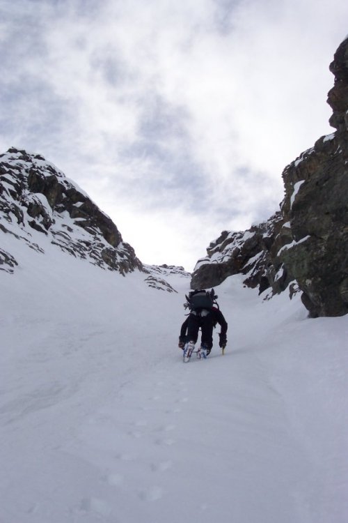
-
[TR] Mt Maude- North Face and North East Couloir 3/22/2004
TeleRoss replied to TeleRoss's topic in North Cascades
Here's a shot of Jason on the North Face. ~Ross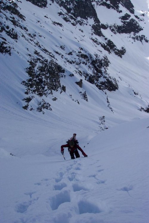
-
[TR] Mt Maude- North Face and North East Couloir 3/22/2004
TeleRoss posted a topic in North Cascades
Climb: Mt Maude-North Face and North East Couloir Date of Climb: 3/22/2004 Trip Report: Jason C. and I climbed and skied the North Face and the North East Couloir (North Face Ice Couloir in Beckey vol. 2) on Mt Maude, this last Monday and Tuesday. After a long boat ride Sunday morning up Lake Chelan and a quick, but extremely fortunate bus ride up to Holden Village we were skinning up Copper Creek. Spent Sunday night in upper Copper Creek. Monday morning skinned up to Copper Creek Pass. Wow, what a spectacular view! Across Entiat Meadows loomed the large NE face of Maude. It was looking pretty intimidating from this vantage point. We could only see the lower portion of the North Face route, but the NE Couloir was in plain sight and was looking sweet. We skied corn snow down into Entiat Meadows and made camp near a moraine at ~9:30am. Removing all but climbing and skiing essentials from our packs we set off for the North Face shortly after 10. Skinning up the moraine towards the gullies we were treated to a show of continuous wet slides waterfalling down the steep East face of Seven Fingered Jack. A pretty impressive show. We skinned up through the lower gullies, and up to ~7,400' where we strapped skis to the packs and donned crampons. Climbing was a breeze, punchy semi firm powder, with some nice small runnels which were nice and firm for climbing. We brought rope and pro but didn't use any of it. When the route turns left a little bit the snow got a bit deeper and made for some steep postholing up the final several hundred feet. Made the summit ~2:30, and were greeted by strong winds at the summit. And although the day had been crystal clear for the entire climb, some major clouds were blowing in from the west. A quick look around and we strapped into the skis and dropped in. Man was it sweet. Steep pow all the way down. We made it into camp just in time for it to start raining and retreated to the tent for a long evening. On Tuesday we didn't really have a plan set for what we were going to do. We eventually decided on the NE Couloir on Maude. After another leisurely morning we left camp at 9:30. It was nice to have our skin track in from the day before, and after leaving the track and traversing below the NE face we were below the couloir. Pretty much the same story as the day before, although the the NE Couloir is a little steeper than the North Face, and the snow was a little punchier. Again crampons and axe were all that was needed. On the summit strong winds again limited our stay, and what looked like a fairly decent storm system was looming to the west. The ski down the couloir was spectacular, a direct line all the way down the couloir, through the lower gullies and into camp....absolutely awesome. That night it began snowing and blowing pretty hard, and in the morning continued to worsen, so we abandoned any hope of more climbing and skiing that day. We had initially planned on staying until Thursady, but bailed on Wednesday due to the weather. An interesting skin back up to Copper Creek Pass, and it was all easy, but wet cruising back down to Holden. Somehow, we had managed to make it to Holden just as the bus was being loaded for the 12 mile trip down to Lucern, and the Lady Express back to Chelan. ~Ross -in the pic the North Face is yellow, the NE Couloir is Red. Ski descents followed the climbing routes. Blue is where we descended the lower gullies to camp. Gear Notes: Brought gear, didn't use it. Approach Notes: Copper Creek from Holden Village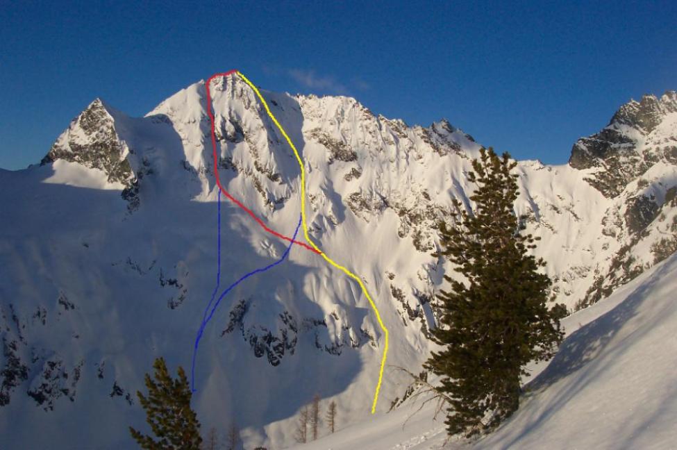
-
first winter ascent [TR] Mt Buckner- North Face 2/20/2004
TeleRoss replied to TeleRoss's topic in North Cascades
Conditions on Cascade River Road are a funny thing. Because the road is so far below the mean snow line, generally the road is snow-free for quite a ways. When we do get some of these prolonged periods of low freezing leveles accompanied by precip., the road becomes impassable early on...sometimes before Sibley Cr. Rd. However from what I have seen, the snow that falls at these low elevations, even on the road, does not persist for long, and again the road is passable for a good long ways. ~Ross -
first winter ascent [TR] Mt Buckner- North Face 2/20/2004
TeleRoss replied to TeleRoss's topic in North Cascades
Looking across the Boston Glacier to Mt Buckner. Taken from the notch below Boston Peak.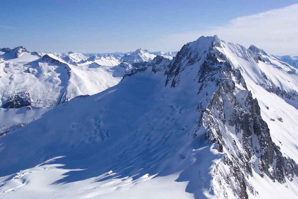
-
first winter ascent [TR] Mt Buckner- North Face 2/20/2004
TeleRoss replied to TeleRoss's topic in North Cascades
Here's a view looking NW from the summit of Buckner....yeah the Boston Glacier is big.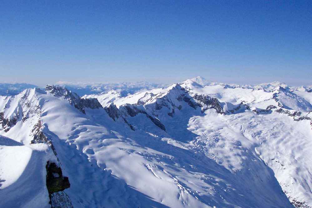
-
first winter ascent [TR] Mt Buckner- North Face 2/20/2004
TeleRoss replied to TeleRoss's topic in North Cascades
Corey and Sky approaching camp...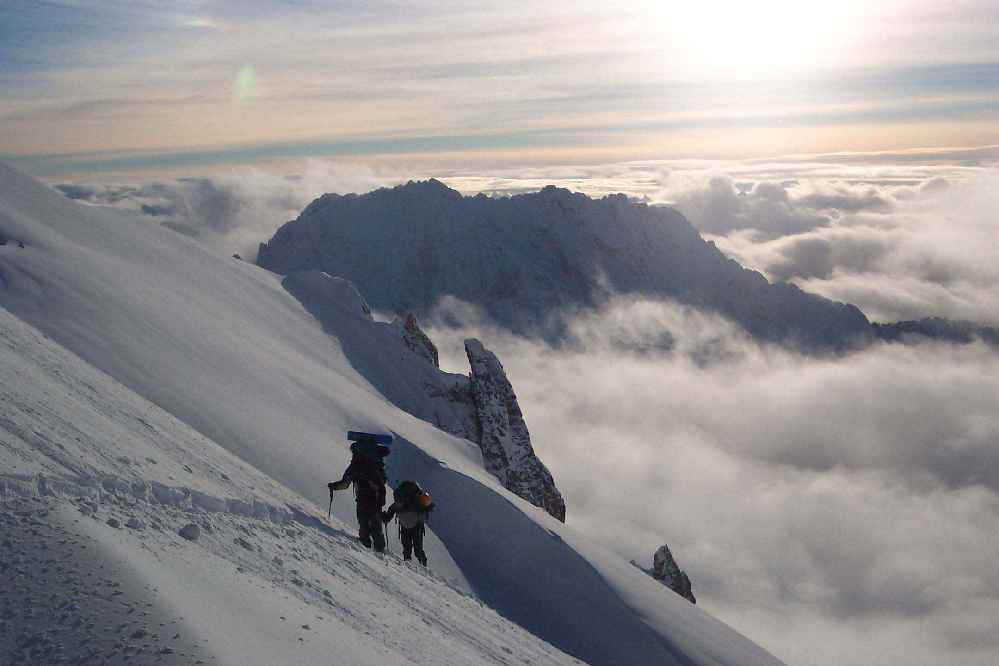
-
Climb: Mt Buckner-North Face Date of Climb: 2/20/2004 Trip Report: Sky, Corey, and myself left Seattle butt-ass early on Thursday morning with plans to climb and ski the north face of Mt. Buckner. After a brief delay to discuss speed limits on hwy 20 with Trooper Joe, we were on our way up Cascade River Road. We were stopped by a large blowdown just past m.p. 18. One final gear organization, and we set off walking up the bare road. ~1/2 mile later we found continuous snow and were able to start skinning. The trip up the road was uninspiring as the views up to the peaks was obscured by low hanging couds. We left Cascade River Road just past Midas Creek. Skinned through open slopes and timber generally following near the creek until we broke above timberline. Here visibility began to become an issue. Solid white out conditions made the going a little slower than normal. But periodic clearings gave us glimpses of the route up towards the Quien Sabe Glacier. Up and around the moraine, and it was moderate slopes all the way up to near 8,000'. There the clouds broke and the peaks began to appear. Johannesburg, Forbidden, Eldorado, Boston, looking like islands floating in the clouds as the layer began to lower and break apart. We camped at ~8200' below a rock outcropping very close below Boston Peak. The next morning crystal clear skies greeted us and lifted spirits. After a leisurely breakfast and gear packing session we were off. Sky lead up the slopes towards the notch immediately S. of Boston Pk. that we were hoping to use to gain access to the Boston Glacier. Postholling was a pain, but it got worse as we entered the gully and encountered sloping slabby chossy crap covered by powdery, thin snowcover. Crampons were employed and a few tricky moves over a couple of rock steps led us to a steeper snow gully leading right for the notch. Sky was leading up and when he shouted "Holy Shit!, Holy Shit!" I thought that things were either really really good or really really bad. When he yelled again, "It's all good!", all questions were erased. The Boston Glacier reached right up to the notch where we were standing, and rolls endlessly away to the NE. To the E. was Buckner with the NF clearly in view. Man it looked sweet. With little time to enjoy the views we donned skis and enjoyed nearly 1500 v.f. of pure Boston Glacier pow. From our low point we put skins on and began climbing towards the face. And we kept climbing, skinning all the way to just past the bergschrund. There we strapped skis to packs and kick-stepped up the face. Climbing was straightforeward, and moderately steep. Highly enjoyable, with the Boston Glacier rolling away far below. Summited at 2:00, and enjoyed the views to peaks in all directions. The notch where we accessed the glacier looked so far away and our ski tracks down the glacier seemed insignificant on the mass of ice. With little time to linger Sky began the ski descent. He stopped a little ways down to shoot some pics of Corey and myself on the descent. The skiing was simply awesome. Wind buffed, soft, powder down the entire face from the summit. All to quickly we were back at our skin track, and began to climb back up to the notch. At the notch we decided to rappel rather than deal with downclimbing, and although it took a bit longer, provided much more piece of mind. At camp we decided to spend the night rather than ski out in the dark. The next morning was another blue bird day and we packed camp and enjoyed ~3000' of fine buffed out powder before finding crusty conditions lower down in the forest. A quick ski out the road and back to the car. PBR's were cracked and swilled, and the outing came to an end. ~Ross
-
I got a great look at it when I was up there earlier this week. I looks sweet. But like you said, LONG, especially the approach. It's basically the same approach I did except then you have to cross the lower Kautz Glacier to reach the cleaver. I should have some pics up in the gallery later tonight. I think I have some that show the Success Cleaver route really well. -Ross
-
Yeah, I was solo, my partner bailed Monday evening due to a cold or something...??? Tuesday on my way up Van Trump Park, skinning conditions were tough because it was so warm, and the snow was pretty wet. I was getting a lot of snow build-up on my skins. Above about 8,000' that became less of a problem though. On Wednesday, the climbing conditions were excellent on the headwall. Snow was mostly frozen and firm. There were some patches of a breakable crust with loose snow underneath that resulted in some knee deep postholing, but those sections were mostly lower down on the face and were pretty short lived. Skiing conditions were less than spectacular. Hard frozen stuff up high, pretty much all the way back to camp. Then below camp there were some good turns, and then areas of breakable crust, and then down below about 7,000' it was crusty, or completely mushy depending on the aspect....pick your poison....then once below tree line the snow was very wet and heavy and made for some interesting maneuvering in the trees.....
-
Climb: Mt Rainier-Kautz Headwall Date of Climb: 2/10/2004 Trip Report: Started Tues at Van Trump TH. Nearly 7,000 v.f. and 6 1/2 hours later was at camp on Wapowety Cleaver. Beautiful day, but really warm. Shorts and tee shirt would have been nice. Got up Wed. morning and began climbing at 2:30. From camp, descended snow slope down onto the Kautz Glacier, directly below the lowest lobe of the ice cliff. From there asceded the open slope to 13,000'. Climbing was really fast and straightforeward. Right below a rock band where rock bands begin to criss cross the headwall, decided to take a rest. Dug a little platform by the rocks and just hung out and watched the most amazing sunrise, as the peaks were one by one illuminated by the sun rays...truely an awesome morning. Thought a little bit about continuing to Pt. Success, but was having such a sublime experience wathing the sunrise that I decided just to hang there for a while. Ended up sitting there for a few hours, and finally decided just to ski down. Broke camp and skied back out to the car, for nearly 10,000v.f. of skiing. Gear Notes: legs
-
[TR] Colchuck Peak- North Buttress Couloir 1/24/2004
TeleRoss replied to TeleRoss's topic in Alpine Lakes
Unless you want to do it because it's fun to do it....what does it matter if its "already been done"? Plus, there's plenty of firsts left in the Cascades. -
[TR] Colchuck Peak- North Buttress Couloir 1/24/2004
TeleRoss replied to TeleRoss's topic in Alpine Lakes
I'm not positive but I think that the Triple Couloirs have been skied....?