


SmilingWhiteKnuckles
-
Posts
132 -
Joined
-
Last visited
Everything posted by SmilingWhiteKnuckles
-
Climb: Dragontail-Backbone Ridge Date of Climb: 9/30/2006 Trip Report: First off, the many trip reports we were able to find either on CC or from CC were not only entertaining, but REALLY helpful with routefinding on this climb. Thanks. I picked up Load around 4:30pm from SeaTac. I was a bit late because of a mad dash to Second Ascent to pick up a NW Forest Park Pass--a friend of mine had gotten ticketed the week prior and The Man wanted her to go to court in Leavenworth to prove she actually had a pass (which she did--it had been left at home). This prompted a last minute purchase. Load was on the curb outside baggage claim, and we were soon on our way. After a huge dinner in the city of lights and a brief clogging session underneath a gift shop speaker, we headed up to the trailhead to do our final bit of packing. The parking lot was full but we didn't see many people. One party drove up to retrieve their other car after a one-day Enchantments hike, but they were battered from the effort and somewhat less than talkative...Woke another dude up by accident who was sleeping by his car. Sorry bro. We got to Colchuck Lake in a couple hours and crashed out in our sleeping bags for a few hours. 5:30am had us up (barely) brewing tea and oatmeal. We brought a bunch of water with us on the climb thinking that there would be none, but there is still water coming down from the Colchuck Glacier near the moraine. We thought: hydrate! and guzzled as much as we could but it just made me nauseated (too early? altitude? what?) . We broke out the crampons for 40ft across the ice and had no trouble scrambling across, around, and up to first pitch. We did two short pitches to the off-width so we could belay from it's base like a few TR's recommended. We also ended up hauling packs with the remainder of our 60m rope. Load graciously led this pitch having stoked himself up for the whole week before and did a great job. He even brought his shiny new Christmas ornaments all the way from Chi-town to decorate this pitch: a red (5) and a green (6) Wild Country cam. I think somebody in one of the Backbone TR's used the word "thrutch" to describe how one gets up this thing. I looked up the word to no avail but figure it's a combination of thresh, huck, and scratch or perhaps instead of huck, there's a fat expletive stuck in the middle. It's a perfect word for how it goes, and we both left our share of ankle bone, skin, and blood in the crack....So wear your latex up there if you're heading up there soon--I'm pretty sure Load's got the disease. Even though I followed, I found this pitch strenuous and a little scary. For sure the crux of the climb. Stepping left from the ledge above the OW, we spied the mentioned and photographed roof. I went up and left of the roof and established a belay on a small ledge next to a really cool layback block (also photographed in some TRs). The next pitch climbed this and then up moderate cracks to blocks on the crest and another belay. After this, we remembered to drop down and again headed climbers left. We did one more belayed pitch from there and then simuled the low angle stuff to the base of the fin. And it was getting windy and cold up there! You could hear the wind blast the fin in wave-like pulses which was neat but a bit unnerving. After a quick snack and drink we proceeded . The first pitch up the corner surprised me a bit by being harder than anticipated. While still moderate fifth, the rock was a funky mix of solid and crap and finding the couple pieces of good pro I wanted took a few minutes. Soon we were below the fin proper though and it looked daunting. The fear was for naught though, cause after pulling the first moves up, one is presented with cool climbing on great rock and plenty of solid placement options. This feature is phenomenal, and I loved these pitches despite the gusts of wind which were enough to knock you around a bit and make you grip and hug the rock. I did get one good photo of Load coming across the traverse on the final Fin pitch--the money shot! We short-roped again for the last bit of climbing, traversing the crappy, crumbling, scary rock above the top of the 3rd couloir which we eventually climbed into and up for the last 60 feet. I am still wondering if there's a more aesthetic--not to mention solid--finish to this otherwise amazing climb. We were really glad for the crampons on the way down. Further reading has me curious about the rap descent, but the snow works fine with light spikes as well. And Asgard? Well let's just say it's been awhile and time seems to create false optimism...It is long--especially if you get cliffed out following the green (and golden--larches) belt down by fading headlamp and have to walk back uphill and traverse until finding the trail again. A great adventure!! Fall in the Enchantments is amazing! Thanks for the trip, G. Gear Notes: Medium rack up to 3" Wild Country cams #5 and #6 60m rope crampons aluminum axe Approach Notes: A small patch of snow getting to the climb (probably avoidable) Glacier on descent (hard ice right now)
-
 We got back to the car around 5pm so nearly 12 hours. Early morning start was crucial.
 -
Climb: Whitehorse Mtn-Northwest Shoulder Date of Climb: 9/17/2006 Trip Report: We headed up in the minivan Sat night and eventually found the right road just west of Darrington where a supposed French Creek Campground was located. After driving up the road a couple miles, we passed several pull outs (which were full) and a bathroom. Going further on up the hill, the pull outs ended leaving us to surmise that those pull outs ARE French Creek campground. The lack of signage struck us as odd, but even stranger was passing two young men walking toward us down the road. We took them in quickly in the headlights. The first carried a gun, a black rifle of some sort and the second carried a lit sterno or something resembling a torch in a ladle with his left hand while his right hoisted a very full-looking silver tarp over his shoulder. Filled with what?... Anyhow, we turned around and passed the dudes who had now planted it near the bathrooms, and wanting to put a bit of distance between them and us, we drove a mile or so back toward 530 to another pullout we had passed (a roundabout actually). We camped there, unfortunately right under the powerline and that strange unnerving, brain-zapping electrical whitenoise bristling in the wires above. Another car came up the road after we had bedded down in the tent and actually drove around the roundabout coming within 3 feet of the tent. Weird. No matter. 4 hours of sleep is just that. We drove to the Niederbaum Trailhead, woke up a party in a tent there while we mowed breakfast and slugged all of the coffee and tea we had and were off up the steep trail at 5:30am. Surprising that as close to Seattle and as accessible as this mountain is, how faint the trail is at times. While we had no trouble following Beckey's route description, the trail getting up to High Pass is totally covered with the long slippery grass which covers the whole hillside. High Pass is right next to the glacier and from there, once we decided that the best way was on the glacier, the going was easy until the summit block. At this point, the summit was shrouded in fog and cloud, and seeing the rather precipitous summit block, we debated about tackling it. But as we did every other step of the way, we said "let's go closer and see from there." Sweet, the summit is this little lump behind us! No, actually this is the real summit. And Beckey's route description held again as he suggests in the absence of a snow finger to the summit to "traverse east ledges and then up." What he doesn't clue you in on is how perilously exposed these moves are. The climbing is class 3-4, but don't fall here! Anyhow it really got the blood pumping. We took it SLOW on the way down and were psyched as always to have attained the summit. We made it!! So this is a cool hike with an alpine finish and a great view of D-town and the valley below. And, any way you slice it, this mother is 6000'+ elevation gain and loss. Bruised-feeling quads have ruled the last few days! Gear Notes: light crampons light ice ax no water on route right now trekking pole would've been good Approach Notes: Trail gets fainter as you gain elevation. Snow free until the glacier.
-
[TR] Nooksack Tower- North Face 8/28/2006
SmilingWhiteKnuckles replied to marcus's topic in North Cascades
I was curious if you can see where you bivied in the photo "Marcus halfway up the route"? -
[TR] Monte Cristo, Kulshan, Shuksan, Daniels- 8/2/2006
SmilingWhiteKnuckles replied to Mauri's topic in North Cascades
Thanks for contributing this report, Mauri. It's fascinating especially for those of us who enjoy our high country here, and as always, good to add facts to the speculation and straight up observation. -
What Goatboy said! The bivy site we slept at (described in Nelson) was a 2-banger. There was another small spot very nearby and snow to melt, but 4 might be tough or at least of questionable comfort. But hell, it's not really about comfort anyway. The following day, we weren't thinking too much about bivies, but there are probably places like Goatboy says...
-
I'm pretty sure you could climb the rock. Might take awhile and involve some snow to rock shenanigans, but I think it'd go...Have fun!
-
Climb: Torment-Forbidden Traverse-Torment-Forbidden Traverse Date of Climb: 8/15/2006 Trip Report: My friend, Giora, and I climbed the Torment-Forbidden traverse in two full days last week. The weather forecast of "partially cloudy" had me a bit concerned, but things turned out great and the clouds really added to the atmosphere without ever turning threatening. Some friends had tried the South Ridge route on Torment the previous summer and got shut down, finding themselves on 5.8-5.9 climbing when the route is supposedly mid fifth. So I guess, I was concerned about that too. Following Nelson's description though, we had no trouble finding our way to the summit of Torment. The climb was easy and fun and the rock was better than anticipated. From the notch below the summit block (the start of the Torment-Forbidden ridge), routefinding became a bit trickier. We crossed a snowfield, passing a few gendarmes. This brought us alongside a wall with the ridgetop high up on our right above us. There was an easy traverse on broken rocks, but we elected to climb straight up mid-fifth class climbing. It took us a couple pitches to summit this formation as we meandered up the easiest lines. Once we got to the top of this hump, we went from being unsure to being stoked. The view of the entire rest of the climb lay before us and the bivy site (again Nelson's route descrip) was a mere 20ft downclimb below. We settled in, put on some warmer clothes and brewed up dinner and more water. What a spot!!! Protected and beautiful. Not a soul around. Wasn't even cold! The next day found us crossing the steep snow (what am I saying, this shit was water ice!) in our aluminum crampons. We had two, Grivel Black Compact tools between us. After crossing the first band of ice to a rock island with one tool. I brought Gi over and told him a sure as hell wanted both tools for the next and way longer section. So I started up from the rock island anchor hoping for enough rope to make the ridge crest. No such luck. I was 2/3's of the way up when Gi shouted "15 feet!" There was a little ice ridge that provided a bit of a stance and I ended up chopping a stance and a bollard for pro. After tying into the bollard (backed up with one of the tools), I zip-lined the other tool and my gloves down to Gi. He was able to nerve his way up with just the one Compact. Another short lead for me and we were finally to the top. Yikes. Gripping stuff. Definitely the crux of the route. The rest of the climb was spectacular. Parts of the ridge were like a sidewalk with thousand feet of air on either side. Gi got his wish for sure! We did two rappels off the ridge during the traverse. One shortly after the snowfield off a gendarme and the other just before the notch at the base of the west ridge of Forbidden. Finishing on Forbidden reminded me of what a spectacular climb that is! We cruised it in 3 running belays. The rock is unbelievably good. We rapped (5) the NEface down to the ledge system and soloed across and back to the base of the east ridge. It was probably 7:30pm, Wednesday, by this time and we sat smiling in the sun for awhile before plunging down into the fog which filled up the Boston Basin below us. We found the way down into the basin but couldn't find the upper camps in the fog and increasing darkness. We found a couple really nice camp spots and ended up just crashing there until dawn rather than beat around in the dark looking for the trail. Morning came and the upper campsites were close, 100yds away perhaps. Oh well, we slept well. Two young women were bivied there and had their stove going when we came by. Out to hit the west ridge that day...Said they heard us at night for awhile, but then it got quiet and they assumed we headed down. Anyhow, this climb was superb. One of the best yet!! Gear Notes: 1 50m, 8.3mm rope med alpine rack lots of slings (~14) aluminum crampons 1 Grivel Black Compact tool each Could've had an ice screw or two.
-
This vantage looks familiar. Are they taken from the top of Sharkfin Tower?? Tony, Jim, and I were up there Sunday--it's a great spot and it was actually cool up on the ridge top! We rapped down and did the two 5.9 Nelson/Bale pitches on the east face? se face? These are excellent pitches with unbelievable exposure over the Boston Glacier. Thanks for the pics...
-
Found Pack and climbing gear I-5 Olive street Exit
SmilingWhiteKnuckles replied to The_Garddog's topic in Lost and Found
A friend and I had a bunch of gear stolen from my car on June 4th in Leavenworth. I had a black pack and a black duffel, both filled with gear. Pack was a Montbell Lightweight Alpine Pack 60L. Let me know if it's a match. Thanks. -
The best shot of the Polish route is above unfortunately. Natch, I wish I had taken more pictures... Hope someone goes in there this weekend!! Conditions are probably still primo!
-
Climb: Colfax Peak-Cosley-Houston route Date of Climb: 12/11/2005 Trip Report: Mark and I climbed the Cosley-Houston route yesterday. Have to agree with dberdinka's assessment of this route from this March. It's really cool. We found similar conditions on the route as he describes in March. And we were able to get to about 2800' on the road--a key bit as skiing up (or down for that matter) the road could be a rather serious endeavor. Seems like this is a good one to hit in the fall or spring. We skied the trail up on Saturday, but ended up hiking back down it (it melted out too much). There was a crazy temperature inversion going on. In the town of Glacier, it was well below freezing and hiking up past the Kulshan cabin site, it was downright balmy and the snow coverage was minimal. Going up the trail, Mark said that the good thing about temperature inversions, is that its usually really still. By the time we got up onto the hogsback, the spindrift flying and the plumes off of Colfax and the Black Buttes lit up in the afternoon sunlight. We camped on the big table about 5800' and did some soloing around on a good ice flow nearby. The wind kept up in long gusts through the night and the whole next day. Skiing up to the base of the route took us a good long time, but finally we got on the route and it was in great shape similar to the conditions described in March. We traversed left after the final ice step, topping out above the Polish Lamb Sausage route. We got to the top just before the light faded. Thankfully, the descent down the east ridge was pretty straightforward. The moonlight was awesome all the way down!! Polish Lamb Sausage looks rad by the way for all you hardcores... Gear Notes: 1 50m rope small rock rack (tricams!!) 5 ice screws 3 pitons (didn't use) 1 picket (didn't use, could have but...)
-
Climb: Stuart-NW face Date of Climb: 3/14/2005 Trip Report: On our second effort in two weeks (first time in, it snowed), Jim and I did the better part of the NW face route on Mt. Stuart Sunday/Monday. Conditions are primo right now and I have to recommend this one strongly to those looking for burly adventure. Our hikes in and out were superb and the only thing to note really is that we didn't bring snowshoes and this was a fine decision, for the trail is nicely packed down. So as soon as they open the #$%(ing gate, there will be easy access to the high country. Monday, climbing day, we woke up at 4am and were walking in 15 minutes. Ran into a couple people bivying up on the moraine. Brrr, it was cold and windy. Apparently, they tried the Girth Pillar day before but one of them dropped a tool so they rapped and in the only words I heard over the wind, "we did the Ice Cliff Glacier...we had to do SOMETHING!" I think this was their second effort... Took us nearly 4 hours (slow and steady) to get from our camp in the trees (5400') to the base of the climb. Weather was perfect, the wind blowing strong enough to remind us that it is in fact winter. First pitch was stiff: steep and sustained, but the ice (water ice!) was superb. After that, we wove our way up runnels and steps for many pitches. Protection was here and there, but the snow and ice remained great. After shooting up this long couloir, we found ourselves next to the gendarme. From there, we angled right up two steep steps and I set up a belay. Decision: either straight up a mid-fifth mixed pitch or right on a snow ramp to the skyline. I hadn't been here before and Jim couldn't remember which way to go. I lobbied hard for going straight up the mixed pitch thinking of the little sketch in my outdated edition of the Beckey guide. We took this mixed pitch up, hurrying now because it was getting late and we REALLY wanted to top out by sunset... Well, this was not the easy way. I led up to the crest of the north ridge, on a knife edge below a 5.8 handcrack. Shit, shit, shit. Neither of us wanted to take this...not now, not with the gear we had. We resolved this quickly as we could by rapping down onto the NE face. We did a ~200 foot traverse and went straight up to the ridgecrest, finishing with some very thrilling steep, unconsolidated, granular snow to reach the last 10 minutes of sunshine. Then it was a long, long downclimb down the Sherpa in the dark and one rappel down some hard glacier ice bulges and back to camp at 8:45pm. What an adventure!! Gear Notes: 2 ice tools and crampons 1 50 meter Edelweiss Dynamic 4 ice screws 2 pickets (very useful) 3 pitons (1 steel blade, 2 ti blades) 5 small nuts 2 med hexes Approach Notes: hard, icy trail
-
[TR] Whitechuck- NW ridge 2/10/2005
SmilingWhiteKnuckles replied to SmilingWhiteKnuckles's topic in North Cascades
subaru forester (4wd) with chains as extra precaution. Yes, unbelievable views... -
Climb: Whitechuck-NW ridge Date of Climb: 2/10/2005 Trip Report: Had an awesome day out yesterday. Felt really good to finally take advantage of another amazing weather window during this rather strange winter (winter?). Conditions are more like fall after the first few snows... Drove up road 2435 to about 3270' by my altimeter. Left the car about 9:20am and made it onto the ridge top via the road about an hour later. I walked up some ruts left by a bigger truck for awhile and then donned snowshoes for pretty much the rest of the approach. I was kicking and laughing at myself in turns for not bringing my skiis. The road would have been an ideal ski approach. It wasn't too bad in snowshoes, just long. From the road's end, the ridge top hike along the NW ridge from Whitechuck's NW peak was amazing. Beautiful views on a sunny, warm day. I hiked in a wool shortsleeve shirt for much of the day. Snow conditions were mainly that there of course surprisingly little. Although the basin to the north of the ridge would have made for fine skiing right now. North slopes were half a foot of powder over a harder layer. Southern slopes were crunchy and crusty in the woods and deep and slushy and sticky in full sun. Once I got into the basin to the SW of the main peak, this made going somewhat more difficult. And once the terrain steepened below the NW ridge proper I found myself putting on crampons for cruxes and taking them off again for deeper snow. Better anti-snowballing plates (than my scuffed Tropicana container cutouts) would have been great! Topped out on the ridge between the NW peak and the main peak and called it good. Time was 3:15pm, elevation: 6590'. Had a bit of a bite to eat and stretch up on the ridge, tightened the boots, took a few pictures and it was time to head back. Dealt with some pretty serious cramping on the way down the steep slopes, but stretched it out and I was able to chip away some ice in the sun and refill my water container which helped (and helped with putting down some more food). Saw a lot of what I think were bobcat tracks on the ridge. Wonderful sunset when I was coming back down the spur ridge. Made one shortcut through the woods on the way back between switchback, but other than that it was the road all the way going out. Back at the car at 7:50pm. Gear Notes: snowshoes, ice axe, crampons. Should have had better anti-snowballing plates.. Approach Notes: see tr
-
[TR] Pinnacle Peak- East Ridge 12/18/2004
SmilingWhiteKnuckles replied to SmilingWhiteKnuckles's topic in Mount Rainier NP
I'm not incredibly familiar with the peaks and routes in the Tatoosh, but perhaps Lane is the peak with at least two long, straight snow couloirs on the north face. Good views of what the peak I'm referring to directly south from the Narada Falls parking lot. Hard to say what the conditions would be like. I'd say doable as there was snow in them. Underneath the snow, would there be ice? Don't know. The ice on Castle's north face didn't look too bad, but it wasn't exactly fat... -
[TR] Pinnacle Peak- East Ridge 12/18/2004
SmilingWhiteKnuckles replied to SmilingWhiteKnuckles's topic in Mount Rainier NP
On the phone, they said the gate would open at 9am and close at 6pm with the Longmire gate closing at 4:30pm. In actuality, all gates were open. We drove in about 7:30am and out about 6pm. -
[TR] Pinnacle Peak- East Ridge 12/18/2004
SmilingWhiteKnuckles replied to SmilingWhiteKnuckles's topic in Mount Rainier NP
I am confused. I'm confused about why they say one thing on the phone and do another. And I'm also confused about why the park is only "open" between 9 and 6pm. -
Climb: Pinnacle Peak-East Ridge Date of Climb: 12/18/2004 Trip Report: After calling Rainier NP Friday and getting the word that the park gate would open at 9am, we elected to leave Seattle at 5:30am hoping that it would open earlier. The drive took us only about two hours, and as we neared the park, the day dawned around the big mountain. Got to the park, and there was no gate to stop us, no one at the teller's booth...hmmmm. Anyhow we drove on up to Narada Falls and parked. We (3 of us) brought skis for the approach. We lugged these up the crux, which was the boulderfield with light snow cover up to the Stevens Pass road. This was snow covered (barely) and made for an easy ski to Reflection Lakes--we didn't even put skins on. We decided to leave the skis by the road. The snow conditions were shit for skiing, but not too bad for walking. Still, we thought the best tool all in all would have been snow shoes...next time. We left the road about 10am and broke a trail loosely following an older one up to the col. 11:20am. We had heard that the north face of Castle gets some ice, but as we approached the col, it did not entice us. There is big potential on the left side of this face (see pic below) however, if the big drip were to come all the way to the snow! We ended up doing the east ridge of Pinnacle Peak(picture). This climb was a blast on this beautiful and unfathomably warm, sunny day. It entailed some ridge scrambling, one pitch of low fifth class climbing(picture) and then up the snowy ridge some more to a generous summit area. (Rock is kind of loose but not perilously so) We were treated to a view of the big one all day(picture), noting tracks up the Kautz Glacier. This was a great place to be Saturday. We had a huge snowball fight up on the ridge and took our sweet time getting down. Got down to the road about dark and skied out. Yeehaw! Gear Notes: Should have brought snowshoes instead of skis. A light rack is all that's necessary. We slung horns for pro almost entirely. One other thing to say: what the hell is up with Rainier NP policies?? First of all, they lied about their hours. Maybe these apply only when there is snow to plow, but the hours as they were told to me!?? What the!...they open at 9am and close the Longmire gate at 4:30pm and the park gate at 6pm--ludicrous. How are you supposed to do any event (the Tatoosh being one exception) in that time frame? Tough to bet on your alpine start...
-
Mowich Lake Road/SR 165
SmilingWhiteKnuckles replied to SmilingWhiteKnuckles's topic in Mount Rainier NP
Thanks for this info. I'll give a shout if we go in... -
Anybody know if this road is open or where it is gated? Observation Rock is the potential destination...
-
I assume you're thinking of doing the South Rib route? If so, this is a fun and challenging mixed route with many possible variations. There may be a stout move at the top (depending on conditions), but it's not a gnarly ridge traverse. The stout move I'm thinking of is right before the north summit--a short pitch of 5.7 rock/snow. The start is vertical then you move up a slab which is probably snow covered. A month ago, the snow was deep and firm and it wasn't hard. Once you make the South Summit, I do recommend going over all three summits (and pulling the "move") so as to avoid descending any of the steep gullies down the east face, and following the hiker/snowshoe path north to the saddle between Guye and Snoqualmie, then right (east) into Commonwealth basin and south on a trail out (depends where you park). I've always been really psyched to have pitons on this route. Have fun!
-
[TR] Chair Peak- Northeast Buttress 2/5/2004
SmilingWhiteKnuckles replied to skykilo's topic in Alpine Lakes
Aha! I can't take credit for those tracks. Saw them from the top. They must have been from Saturday. I put in a thin line of the route I took which I guess would be the NE face of the NEB or something like that. The route you took looks exciting. How was getting around the big rock block on the upper part of the buttress?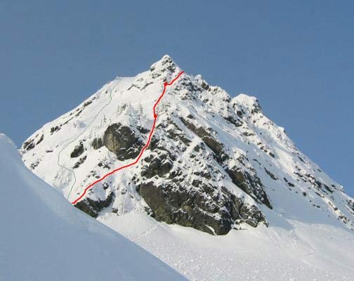
-
[TR] Chair Peak- Northeast Buttress 2/5/2004
SmilingWhiteKnuckles replied to skykilo's topic in Alpine Lakes
You are most welcome! Did you follow my beginning line up the main funnel for the face above or did you go to the right up through the rocks? The ice/snow in the first section was great! -
Considering the G. Skoog/G. Brill route on Gunsight next week. I understand there has been some rockfall on that route. Anybody have verification of this or know if the route has changed much because of it?