


Paul_K
-
Posts
110 -
Joined
-
Last visited
Content Type
Profiles
Forums
Events
Posts posted by Paul_K
-
-
One thing that has saved me from blisters is runners socks. They are made up of two thin layers which I wear under a thicker sock. I haven't had any problems since I started using them, even with heavy mountaineering boots.
-
Here is an automated weather station at Potato Hill, which is close to the Killen Creek trailhead. http://raws.wrh.noaa.gov/cgi-bin/roman/meso_base.cgi?stn=PTHW1
-
I usually camp at the Cutthroat Lake trailhead. It's about ten minutes down the road from the hairpin, and it is a couple of minutes off the road. No charge, no services, but it has a lot less of a mosquito population and is quiet.
-
Here is an alternate access to the Killian creek trailhead that tends to open up
Directions -
Leave Randle south on Forest Service Road 23.
After a long stretch there will be a Y intersection with FS 21 going left and road FS 23 going right. Take FS 21.
You will stay on FS 21 for a little over 4 ½ miles, and then you will reach another Y intersection, Here FS 21 goes left and FS 56 goes right. A problem is that I couldn’t see any marker for FS 56. However at the Y there is a sign pointing to the right that says “Cody Horse Camp 5 Mi”
Take FS 56.
Another check is shortly after you get on FS 56 you will pass the Adams Fork Campground.
Shortly after that there is another Y with FS 56 going left and FS 5601 going right. Stay left on FS 56.
In 4 ½ miles at a 90 degree angle to the right is FS 5603. It is marked on a small sign halfway in the bushes on the right of the road. Take FS 5603.
In about 5 miles you will reach a four way intersection. FS 5603 continues on and the cross road is FS 2329. FS 2329 is a rough dirt road. Turn right on FS 2329.
You will then drive on this road until you are stopped by snow. We passed Keenes Horse Camp and passed the turn off to Horseshoe lake and got stopped by snow just before the road crosses Killen Creek and the Killen campground. From here it is about a half a mile walk to the Killen Creek trail head. It will be on your left.
-
I've just gone through replacing my old mountaineering boots. I too have low volume narrow feet and after trying on quite a few boots I settled on the La Sportiva Nepal Evo GTX. I've had them out several times now and have been happy with them.
They do seem to lock down the heel better than the others I tried, and I haven't had any heel slip with them.
-
For what its worth - Here is a site linked to an automated weather station at Fish Lake.
Looks like there is still a lot of snow.
-
When I teach some one to climb I try and stress two things. First, I am showing them a safe way to climb, but for most everything they learn there is another safe way. For example, I tie in with a rewoven figure eight, but there are other safe ways to tie in.
Second, I stress situational awareness. If you are on flat ground at the base of a climb, you don't need a SERENE anchor - a sling looped around a stout boulder is just fine; because the worst that can happen is the belayer is dragged around a bit if the leader falls. If you are 800 feet up building an anchor with the hardest moves of the climb coming up, you do want a stout redundant anchor.
There are always safety trade offs. You can build SERENE anchors all the way up a climb and then end up rappelling in the dark.
-
From the forest service web site it looks like road approach to the Killian Creek trailhead is melted out if you are coming from the east. This approach usually melts out much quicker that the approach from the west. Here are directions to approach from the east -
Directions -
Leave Randle south on Forest Service Road 23.
After a long stretch there will be a Y intersection with FS 21 going left and road FS 23 going right. Take FS 21.
You will stay on FS 21 for a little over 4 ½ miles, and then you will reach another Y intersection, Here FS 21 goes left and FS 56 goes right. A problem is that I couldn’t see any marker for FS 56. However at the Y there is a sign pointing to the right that says “Cody Horse Camp 5 Mi”
Take FS 56.
Another check is shortly after you get on FS 56 you will pass the Adams Fork Campground.
Shortly after that there is another Y with FS 56 going left and FS 5601 going right. Stay left on FS 56.
In 4 ½ miles at a 90 degree angle to the right is FS 5603. It is marked on a small sign halfway in the bushes on the right of the road. Take FS 5603.
In about 5 miles you will reach a four way intersection. FS 5603 continues on and the cross road is FS 2329. FS 2329 is a rough dirt road. Turn right on FS 2329.
You will then drive on this road until you either are stopped by snow or reach the trailhead.
-
I used to use a liner and thick sock, but still had problems with blisters. Then I started using a runners sock as a liner and have not had a blister since.
A runners sock is a two layer sock. The only thing to be careful of is adding to much volume.
-
FWIW from the Wenatchee Forest web site -
"Fish Lake Road #4330 is open to passenger cars to Scatter Creek. There are eight washouts beyond Scatter Creek; high clearance 4X4’s have driven to the end of the road."
-
Here is a description of a different route to the Killian Creek trailhead that usually melts out much earlier than the standard route. Last year we got to about 1/2 a mile from the trailhead in early June. -
Directions -
Leave Randle south on Forest Service Road 23.
After a long stretch there will be a Y intersection with FS 21 going left and road FS 23 going right. Take FS 21.
You will stay on FS 21 for a little over 4 ½ miles, and then you will reach another Y intersection, Here FS 21 goes left and FS 56 goes right. A problem is that I couldn’t see any marker for FS 56. However at the Y there is a sign pointing to the right that says “Cody Horse Camp 5 Mi”
Take FS 56.
Another check is shortly after you get on FS 56 you will pass the Adams Fork Campground.
Shortly after that there is another Y with FS 56 going left and FS 5601 going right. Stay left on FS 56.
In 4 ½ miles at a 90 degree angle to the right is FS 5603. It is marked on a small sign halfway in the bushes on the right of the road. Take FS 5603.
In about 5 miles you will reach a four way intersection. FS 5603 continues on and the cross road is FS 2329. FS 2329 is a rough dirt road. Turn right on FS 2329.
You will then drive on this road until you are stopped by snow. We passed Keenes Horse Camp and passed the turn off to Horseshoe lake and got stopped by snow just before the road crosses Killen Creek and the Killen campground. From here it is about a half a mile walk to the Killen Creek trail head. It will be on your left.
-
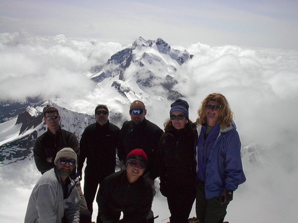
Mizukie in the red hat on the summit of Whitehorse. Very strong, very kind and invariably upbeat.
-
I've had a FF Helios jacket for a couple of seasons. For Cascade climing I've been very happy with it. It packs down small, yet provides a great deal of warmth. It has held up very well.
-
-
Here is the recent Candian forcast for Squamish.
-
-
White middle class suburban kids dressing like gangsta rappers.

-
I know I've seen some discussion of the Cold Cold World Chaos - does anybody have experience with carrying heavier loads - 50 lbs or so with this pack?
-
Here is a technique I've seen used that seems to work well. First set up the rappel and then butterfly both strands of the rope together starting at the ends.
Then put a single runner under the coiled rope and clip both ends of the runner to your harness. As you rappel the rope pulls smoothly off the stack.
Next time I have an easy sport rappel I'll experiment with it.
-
If you are looking at people hiking at the Grand Canyon you are probably looking at a high percentage of inexperienced people who are unaware of objective hazards.
Go up to the Big Four Ice Caves some sunny summer weekend and you will see lots of carnage from people who have no clue about the hazards of steep hard snow. One time I was up there and watched a mother and a couple of young kids in tennis shoes start off traversing a 25% hard snow slope. There route would have taken them above a long twenty foot deep moat filled with sharp rocks. If they had continued on I'm sure at least some of them would have slipped and fallen in. I talked her out of it.
-
The Cutthroat Lake trail head has some nice bivy spots and is a lot quieter than the Blue Lake trail head.
-
I can't count the number of times that when I mention I have a twin sister (I'm a guy) I'm asked if we are identical!
I usually tell them she is shorter than me.
-
I've just picked up a pair of the pants, and used them the first time two weeks ago on Das Toof. I was concerned that they would be to warm, but they worked fine. They really shed the snow well & kept me quite dry.
Cold Cold World Chaos Backpack
in The Yard Sale
Posted
Size large - 70 liters. In very good shape, used on two overnight trips. Great pack, it just didn't fit my body type. $160. kramlich.pf at comcast dot net