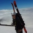
JuanBelay Posted August 24, 2009 Share Posted August 24, 2009 (edited) Trip: Sawhorse Tower (Approach Only) - SW Face Date: 8/24/2009 Trip Report: On Saturday August 22, 2009 I made an attempt on Sawhorse Tower in the Monte Cristo group of peaks in Washington's North Central Cascades. The climb was listed as a Mountaineers basic rock climb so that my partner could get rock credit, but the primary objective was to get a rock climb in and learn a little more about the Monte Cristo area. I was hoping that Sawhorse Tower may turn out to be a good alternative to some of the more often climbed Mountaineers basic rock climbs like The Tooth, Ingalls Peak, and South Early Winters Spire. I also wanted to get a better look at East Wilman's Spire, an objective that's been on my list for a while. As such, this was somewhat of an exploratory outing. In researching the climb, I checked Beckey's Cascade Alpine Guide Vol. 2 where Sawhorse Tower is listed as four pitches of fourth and low fifth. However the notes are spare and the approach notes did not make a lot of sense to me considering virtually none of the geographic features are listed in my mapping software or any of the other planning resources available. I also checked for trip reports on-line and found one from a pair who had done the climb a few years back, but had taken a bit harder line (http://cascadeclimbers.com/forum/ubbthreads.php?ubb=showflat&Number=51381). Since they had done something entirely different from both an approach and climb standpoint, it was good reference material, but left me with some questions. We decided to take the Beckey approach, and while the outing was a great alpine traverse, we did not make the summit. By the time we got to the rock, it was a little before 3 PM. We had decided to exit a different way than we had approached and expected some route finding challenges as a result. Since the days were getting shorter, we decided to bag the climb at the base and head out. However, I thought a trip report may be useful to provide a record of some details about the approach and some pictures of the climb. In the end, I think this would be a very worthy objective as a basic rock climb for a strong group of beginning climbers interested in a true alpine rock climb. It involves everything including mountain biking, route-finding, off-trail traverses, steep scrambling, glacier travel, and four pitches of alpine rock climbing – all in a very beautiful setting, and all with the historical point of interest of the Monte Cristo ghost town. Gear Notes: Ice Axe Crampons Harness, Rope, Rack for a route of class 4 and easy 5 Approach Notes: Getting There To get to the climb, drive to Barlow Pass on the Mt. Loop Highway (Seattle to Everret, Highway 2 to Lake Stevens, Lake Stevens to Granite Falls, and then 28 miles from Granite Falls on the mountain loop highway). Parking is available and plentiful. A trail Park Pass is required. From Olympia, the drive is 2.5 hours so from Seattle I would suspect a 1.5 hour drive. Approach The first step in the approach is getting to the Monte Cristo townsite from Barlow Pass. This four miles is best done on mountain bike as it's an old road. There are several washouts along the away and sections with river rocks, so a bike with full suspension is most comfortable. I would expect the average rider to cover the four miles into the Townsite in 45 minutes and the trip out in 25 minutes. This saves 2-3 hours of walking overall. Once at the townsite, a bike rack is provided to lock bikes up. From there, the approach is on trail. There are essentially three ways to approach Sawhorse Tower. Two options involve getting to Glacier Basin, the third option involves heading to Poodle Dog Pass and Twin Lakes. To get to Glacier Basin, follow the obvious signs from the Townsite. Ascend on steep trail for two miles and 1500 feet to Glacier Basin. Once in Glacier Basin, hike up the basin a short way and then begin an ascending traverse to climbers left. The traverse can be done via a snow filled gully which get you above cliffs. If moats prevent you from exiting snow at the top of the gully, a ramp exists to climber's left about 2/3 of the way up the gully. This ramp can be traversed to stubby evergreens. These evergreens can be scrambled (near vertical but easy) to get above the cliffs. This is a bit of a bushwhack, but it's fairly easy. Once above the cliffs, begin an ascending traverse of scree and then snow, and finally granite blocks to get to the toe of the Glacier. In early season, the glacier should be a simple walk up. However, later in the season, the glacier bulges in the center, is reasonably broken up, and consists of exposed blue ice. Crampons are recommended. Instead of ascending the glacier directly, one can ascend the toe of the glacier on the right hand side, and then get back on the rocks. Pleasent scrambling on blocky granite gets you almost above the bulge. A short ascent of snow gets you on the flat part of the glacier above the bulge and easy climbing to the obvious Wilman's Gap. At the top of the glacier, downclimb vertically 8 - 10 feet into the moat between the glacier and the rock of Wilman's Gap. Ascend a shallow gully on the left hand side of the gap for 30 feet (class 3). The rock here is mostly just consolidated mud, so hand and foot holds should not be considered reliable when getting to Wilman's Gap. In early season, this is probably easier going due to snow covering the gap. From the gap, descend 150 feet of very loose scree. Care should be taken here due to extreme rockfall hazard. Ascend the '76 Glacier to the base of the Tower (10 - 15 minute walk once on the glacier). Sawhorse Tower is the last tower on the ridge before Columbia Peak. It is wider at the base and taller than the towers to it's left. Allow 5 - 6 hours to get to the base of the route. As an alternative to approaching via Glacier Basin, an approach can be made via Poodle Dog Pass. While we did not come in this way we did exit this way. It's longer, but is mostly on trail. Based on our time out, I would expect the approach from this direction to take 4 - 6 hours. You could possibly save a little time compared to the Glacier Basin approach, but it's not quite as interesting. Some notes about the approach from this direction: At the point in the approach where the trail rounds a tree covered knob to descend to Twin Lakes, find a climbers trail to the left which ascends the SW ridge of Columbia Peak. Use this trail to ascend the ridge to where accessing the '76 Glacier is possible. Descend about 200 feet on the glacier and traverse/ascend to the base of Sawhorse Tower. Wilman's Glacier with Wilmans Gap on the far right Moat at Wilmans Gap Sawhorse Tower SW Face Sawhorse Tower and '76 Glacier Ascending Blocks Beside Wilmans Glacier Approach from Glacier Basin is up the snow gully on the left. If moats prevent exit, a ramp and then evergreens lead through the cliffs from about 2/3 of the way up the snow. Edited August 24, 2009 by JuanBelay Quote Link to comment Share on other sites More sharing options...


Recommended Posts
Join the conversation
You can post now and register later. If you have an account, sign in now to post with your account.