

mrice1225
-
Posts
37 -
Joined
-
Last visited
-
Days Won
5
Content Type
Profiles
Forums
Events
Posts posted by mrice1225
-
-
Guye Peak south gully had great alpine ice on Saturday. Most of the gully was hard snow and ice, and there were around 4-5 short mixed steps (~M3) which generally had solid ice above/on them, making for some super fun climbing, including a layback move on ice sticks with high feet on rock edges. A lot of the trees had tat on them already, some with rap rings. Knifeblade pins were useful.
-
 1
1
-
-
That looks sick, thanks for the pitch breakdown and pics.
-
You could do something like chair peak circumnavigation at Snoqualmie pass? People normally ski this, but I don't see why you couldn't snowshoe it.
-
Was waiting for this one! Thanks for posting. Congrats guys, epic trip report and pictures.
-
 1
1
-
-
Thanks for all the hard work you've put into the area. Haven't checked it out yet but I plan to. Seems stiffer than the cougar mountain/black ice crags... I'll definitely be top roping

-
Great trip report and great pictures - glad everything turned out the way it did. Hope you have a speedy recovery!
-
15 hours ago, bargainhunter said:
Thanks for the beta! With your trip report (and reading over ALL of the older ones on CC) I was able to climb it confidently solo on Friday 8/14/20. Winnies slide almost shut me down. The ice halfway up gave me serious pause. Bad runout into rocks. I had perfect conditions but easily see how one can epic on several of the sections. Crevasses, falls, bad weather (wind/white out on the sulphide summit plateau) and I sure as hell wouldn’t want to try to descend down the Chimneys in the dark or in rain. It would be easy to loose the trail over the talus patches on the way back to Lake Ann from the base of the Chimneys at night as well. Full value strenuous day.
Knowing about the glacial run off at the upper Curtis was great for hydration. There were snowmelt drips even on the summit pyramid, which is a lot bigger/longer that I thought.
Glad I took steel crampons (Grivel G12s) on my Scarpa Rebel carbons instead of aluminum crampons. Camp Corsa axe did the job but two Quarks would have been more secure on Winnies and Hell’s highway. If I had had a rope I might have rapped it. The boot track from previous parties made navigation a no brainer and relieved a lot of stress (thank you!) , but the track had faded when I descended in the afternoon. Wands or GPS breadcrumbs would be useful if it’s misty/low viz. Crevasses were visible and bridges were solid, but I would have turned back immediately if I felt sketched about the solidity of the lips/bridges. Also, the moats by the rocks can be treacherous.
I had been wanting to do this route for 30+ years. Definitely a satisfying mountaineering goal! Beckey described it as torturous. I’d call it extreme walking. Classic!
Glad you were able to get it done! Definitely extreme walking. I agree with the sentiment about the quarks, I used a sum'tec and quark to ascend winnies slide since it was very icy in the morning. A single tool would have been fine but I brought two in case the slide was pure ice like it was last year around this time, so might as well use them!
-
5 hours ago, mountainsloth said:
Bummer on the failed summit. So close. Why was your buddy sick? Sounds like the universe is fighting you hard on this peak. Keep trying and be more careful on the descent. 👃 🤕
Thanks for the encouragement, yeah it was close, he says he thinks it was a mix of dehydration (not peeing all day) and exertion. Will probably try it again, since the climb itself is so much fun over such varied terrain. The summit pyramid has a ton of really loose rock, but yes I should have been more careful knowing there was a party below. Luckily it wasn't too bad.
-
1
-
-
Trip: Mt Shuksan - Fisher Chimneys
Trip Date: 08/09/2020
Trip Report:
On Sunday my friend and I attempted a car to car climb of the Fisher Chimneys, so here's a quick conditions update. The road was gated at the Chain Lakes trail head, about 0.35 miles before the Lake Ann trail head, although I believe they are clearing it today so parking at Lake Ann should be open soon. This was my second time attempting the route - the first time all sorts of shit went wrong (rain, forgetting stuff in tents) and we bailed. This time the weather looked perfect and we were feeling good.
We left the car at around 2am, which may have been too early. We were tired and moving slow - more "sleep" might have been beneficial. The chimneys are completely snow free, although there is some snow at the entrances to the chimneys which currently poses no problem, although it could get weird as it melts out more. Route finding in the chimneys is pretty straightforward - if you don't see an obvious trail or mostly moss free rock, you're probably off route.
In the start of the chimneys:
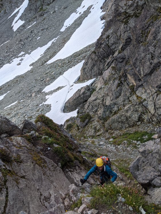
Winnie's Slide is still mostly covered in snow. There are two small ice patches on the left hand side, and a perfect staircase on the right hand side. Gaining the upper curtis is also still mostly snow, but is melting out quick and could become icy soon. The upper curtis itself has a few crevasses starting to open up, but we were able to easily step over them. Hell's highway had a nice boot pack going up as well.
On the upper curtis:
It was around noon, everything was going great, and we were halfway up the SE rib on the summit block when my partner got sick and started puking. We made the call to bail since we still had a long day ahead of us. Conveniently there is a rap station halfway up the SE rib which puts you back at the base of the summit pyramid. On the rappel I dislodged a rock, which launched straight at a party below me. I yelled rock and it ended up hitting some guy and giving him a bloody nose. I apologized and we began our descent.
The rappel station above Winnie's Slide looks impossible to get to right now due to the moat, but down climbing is no problem. There are also plenty of rappel stations in the chimneys if you're not comfortable down climbing. The slog back to the car was pretty miserable, and we finally got back at 8:30pm.
Gear Notes:
Glacier gear, small rack for the SE rib, second tool unnecessary for Winnie's slide
Approach Notes:
Might be moat problems soon to get into the chimneys -
Great write up and pics, the steep heather sections sound heinous! Pretty sure I would shit myself.
-
 1
1
-
-
Great approach beta, thanks for posting!
-
4 hours ago, Bronco said:
There's these new fangled "sun hoodies" that are advertised to keep people cool and are kind of a replacement for sunscreen. Always get the matching set with your tech bros, duh!
At cascade pass this weekend I saw a group of three all with matching sun hoodies, thought it was kind of weird. Must be the new cool thing.
-
Awesome pictures! Looks fun.
-
"Everything you see on the screen is real. Eleven men and women were killed or injured on these mountains during the months it took to film High Ice."
Uhhh what. This is great.
-
I use this site to get an idea for snow coverage:
https://www.fs.fed.us/r5/webmaps/SierraSnowDepth/
By default it shows California but you can just scroll up to Washington to the area you want. I've found it to be pretty accurate.
-
2
-
1
-
-
13 hours ago, JasonG said:
Nice! Looks like better wedder than I would have thought. I worked on my fence in the rain. Go figure.
Yeah we expected it to be kind of rainy/snowy with maybe whiteout conditions for at least part of the day, but we got lucky and the weather was great all day.
-
Nice, did this two Fridays ago, I thought the moat thing where you have to walk under the huge block of snow guarding the notch was interesting, and might get spicier as it melts out more.
-
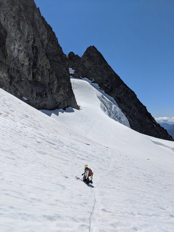
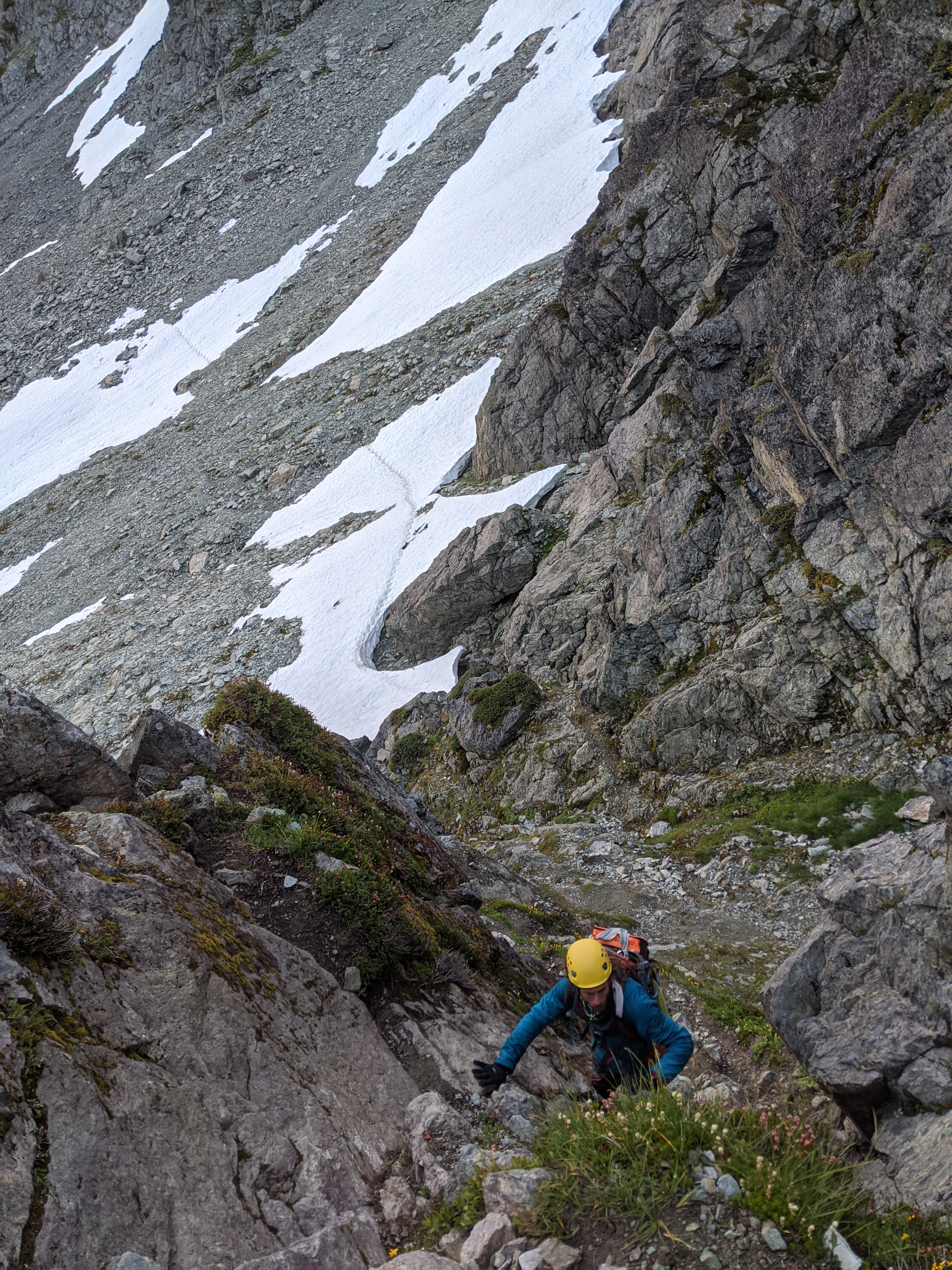
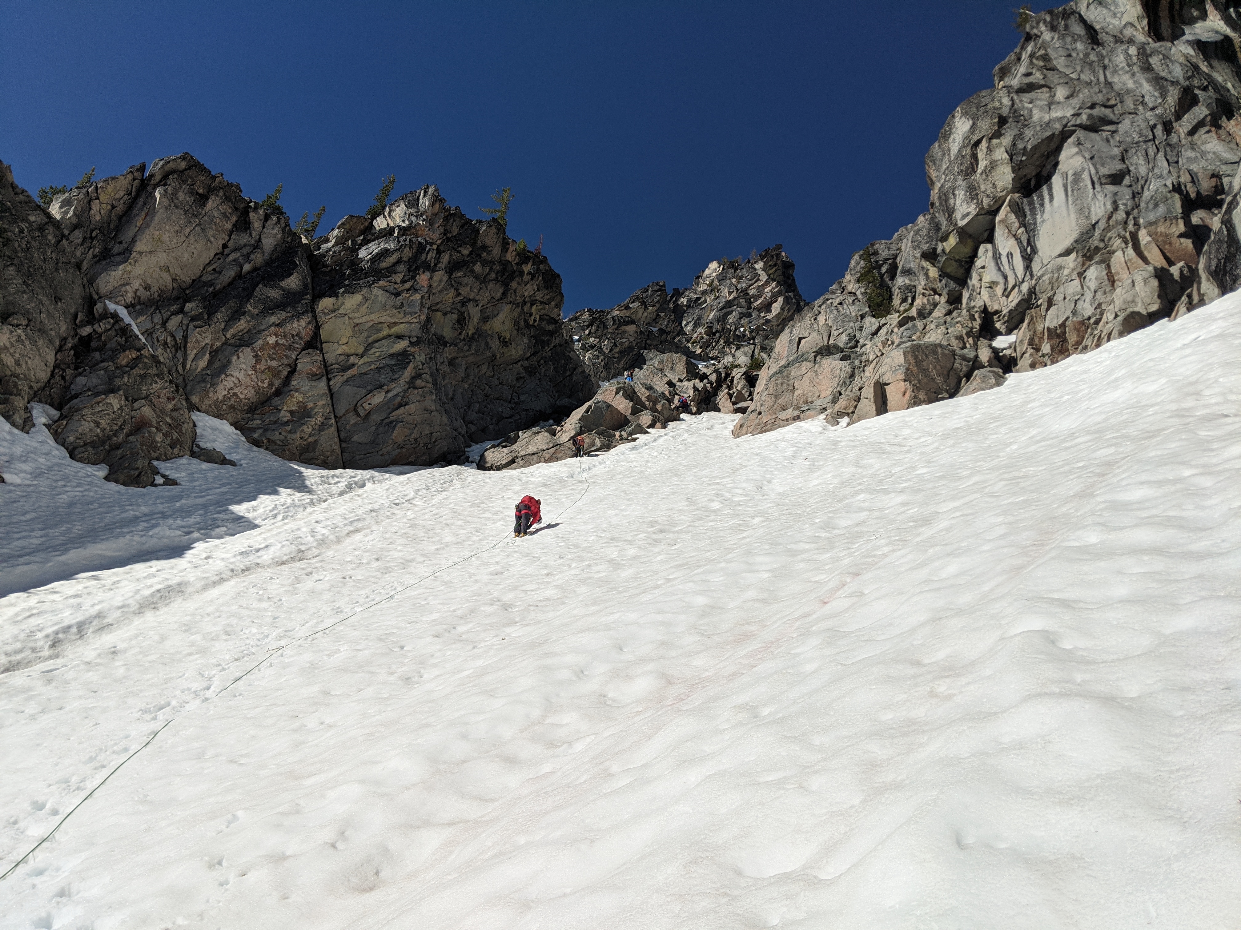
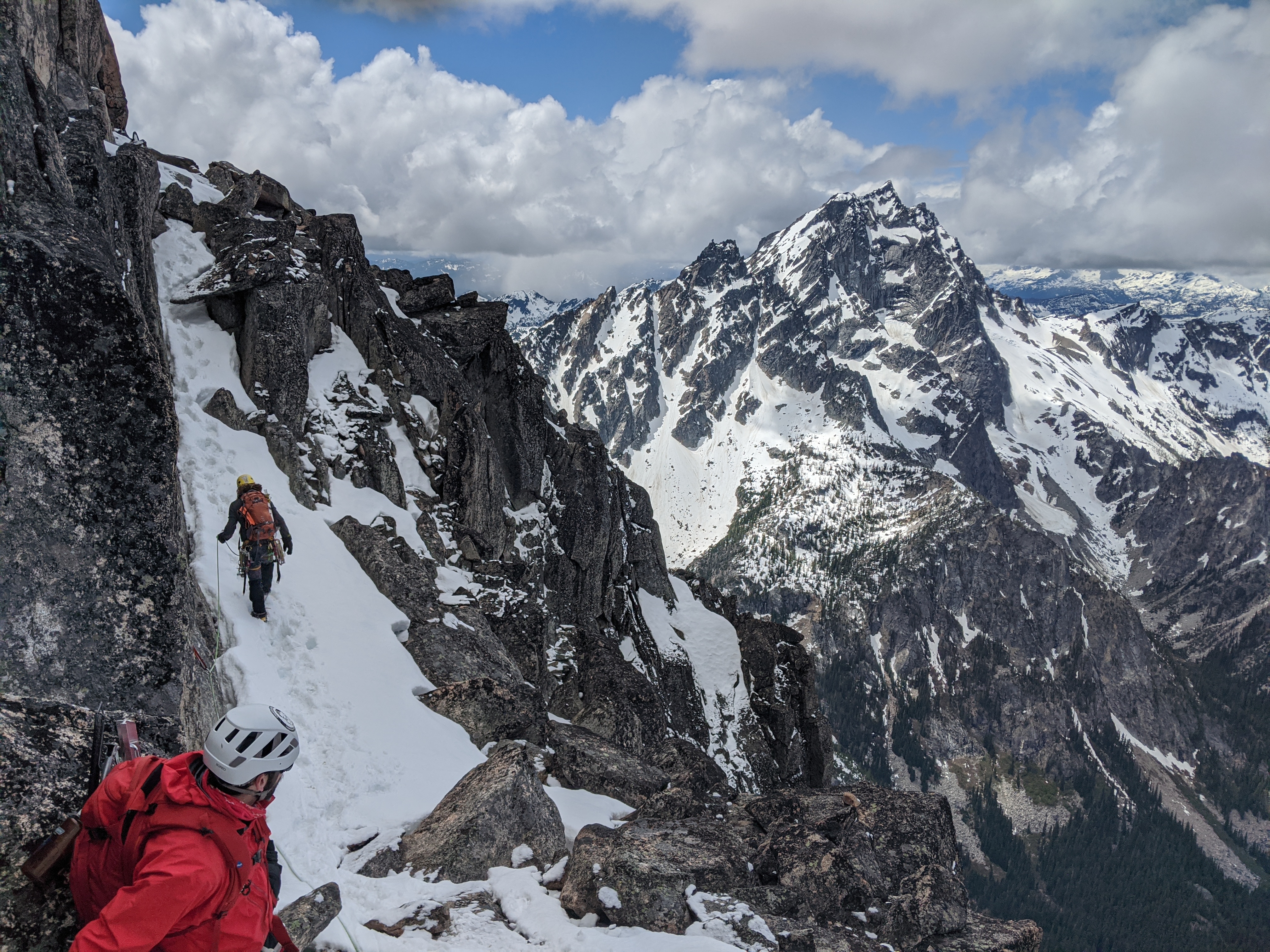
Trip: Colchuck Peak - North Buttress Couloir
Trip Date: 06/06/2020
Trip Report:
Yesterday myself and two others climbed the North Buttress Couloir on Colchuck peak. We started from the car around 3am, with the parking lot nearly full. After stopping by the lake to filter water around 5am, we got to the base of the couloir around 7am. As mentioned in other reports, the couloir was already in full sunlight.
We stayed high and right to enter the couloir, which seemed like the correct choice. Our plan was to simulclimb the entirety of the route. As we started to climb the couloir, we encountered two moats. The first one was passable with some great ice sticks and high steps, while the second had to be navigated around with some very awkward rock moves. This ended the difficulties in the couloir and the rest was just steep snow. We climbed the couloir in two pitches, the first covering most of the ground up until about 300 feet from the notch, and the second to reach the notch. There were plenty of options for protection in the rock, and the snow was decent for vertical pickets.
The start of the couloir; the moat is barely visible on the far left hand side. A party of two chose to bypass it with the rock step to the right.

Climbing in the couloir:
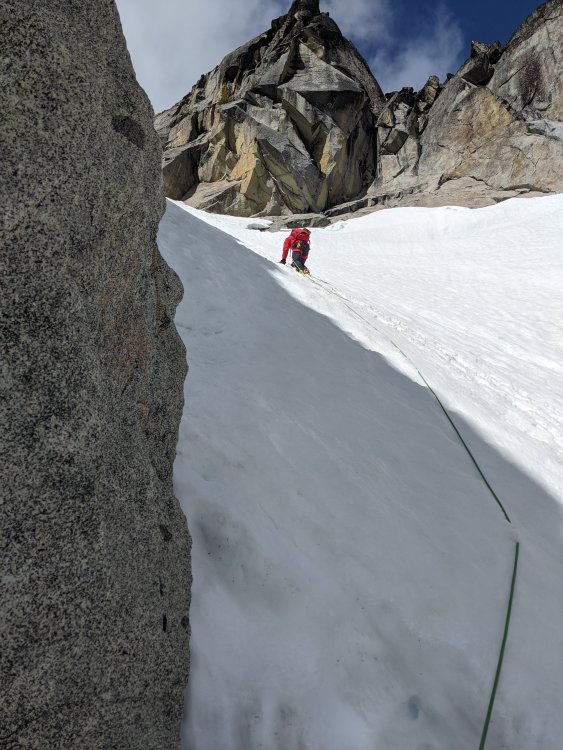
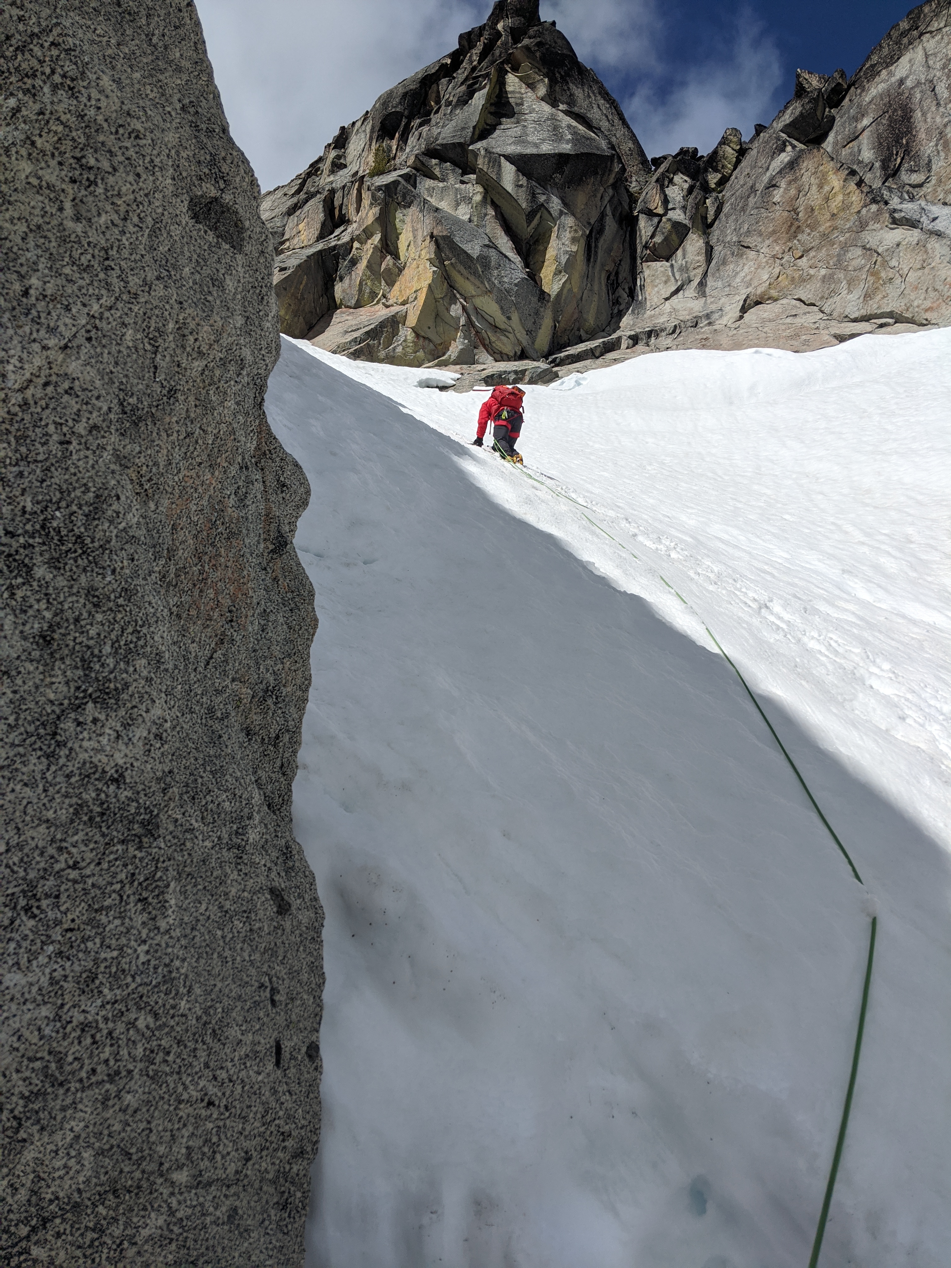
At the notch we led out towards the right about 150 feet, and then started moving upwards. There were a couple of thoughtful mixed moves, as well as an ice step to pull over. Overall the face seemed steeper and more exposed than the couloir. We headed straight for another notch below the true summit, reaching it in a single long simulclimbing pitch. At this point there was a party of two who were soloing who got stuck behind us, as the snow finger was relatively narrow. Once again, there were plenty of options for protection on the face in the exposed rock.
Once we reached the notch below the summit, we let the party of two pass us and then led out to the far left, then right up a chimney type feature. This spat us out below and to the west of the summit still. We had one more short pitch with a few interesting fifth class moves to reach the main summit area. We chose to keep our crampons on for all this climbing as there were still some snowy spots.
At the notch after the northwest face, climbing up and then to the right:

Traverse below the final wall to reach the summit area:

We reached the summit around 1:45pm. We ate some food and hung out for a while, then headed down the Colchuck glacier route. After some moderate snow downclimbing, we decided the glacier was in good enough shape to glissade down, even though some people were choosing to walk down. A kind of quick glissade (I'm slow) got us to the lake and our approach shoe stash at 5pm, and to the car by 6:45pm.
Overall this was a really fun climb, and it's still in decent shape. The moats will certainly become more problematic as time goes by but it seems like you can bypass them with the rock step. The cold temperatures helped keep the snow from getting too slushy in the sun.
Gear Notes:
3 pickets, 0.5-#2 C4s, rack of nuts, a few slings, one ice screw. We placed basically all the gear except the screw.
Approach Notes:
Stay far right once past the lake and follow snow bands up to the base of the couloir.-
2
-
1
-
-
This is awesome, plenty to dream about and research during the stay at home order. Thanks for putting this together!
-
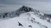
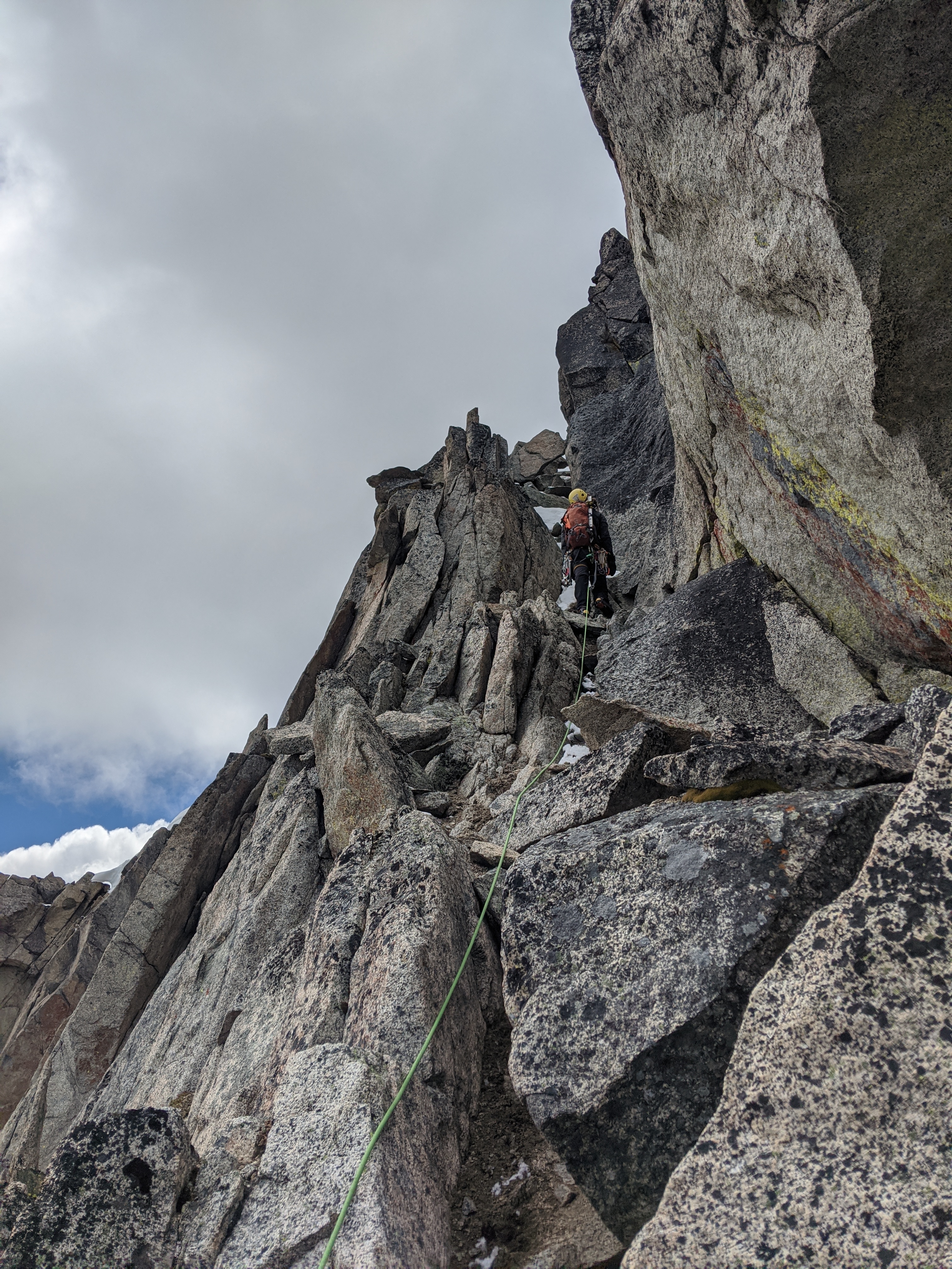
Trip: Guye Peak - South Gully
Trip Date: 03/08/2020
Trip Report:Parked at summit west and left the car around 7am, heading up the road towards the Sahale Ski club. We walked up the ski area (or whatever that place is) and headed towards the south side of Guye. We didn't traverse quite far enough east before starting to climb, but it worked out as we ended up meeting with the gully. At the first step a hundred feet or so up the gully we roped up, and then climbed the gully in three pitches including some simulclimbing. The gully is in excellent shape - most of the snow is hard and compact and there are great sticks to be found everywhere. The amount of snow right now hides most of the difficulties including the chock stone.
At the end of the gully we traversed to the right out of the gully onto a face, where we then climbed steep and sometimes unconsolidated snow trending up and left back into the very top of the gully. Another team took a left variation at the end of the gully, which apparently goes as well.
Got to the top of the south summit at noon and traversed the ridge towards the north summit, doing a single rope (60m) rappel from the tree on the middle summit and climbing back up steep snow to the north summit. The route down commonwealth basin is well defined and leads back to the highway underpass. Back at the car at 3pm.
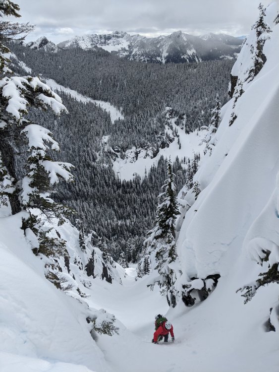
Gear Notes:
Small cams, nuts, knifeblade pitons, picket
Approach Notes:
Snowshoes -
Damn that looks like it hurt. Glad you're alright! Great write up, thanks for posting.
-
1
-
-
Sick. Makes me want to drive down and check out Mt Hood.
-
Great climb, interesting to see pics of it and the pass in the current low snow conditions. Thanks!
-
33 minutes ago, bedellympian said:
PLB?
Personal locator beacon. Glad he was able to mostly self rescue though.


UFO Sightings while climbing
in Spray
Posted
In the moment I swore I saw a UFO while bivying in the white mountains in NH during the presidential traverse. It looked like a bright star moving in a strange unpredictable pattern in the sky, definitely not a satellite. Looking back on it I attribute it to lack of sleep and extreme fatigue.