
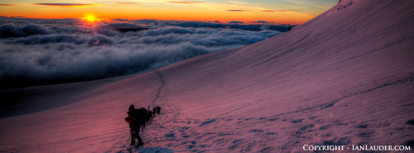

Ian Lauder
-
Posts
61 -
Joined
-
Last visited
-
Days Won
8
Content Type
Profiles
Forums
Events
Posts posted by Ian Lauder
-
-
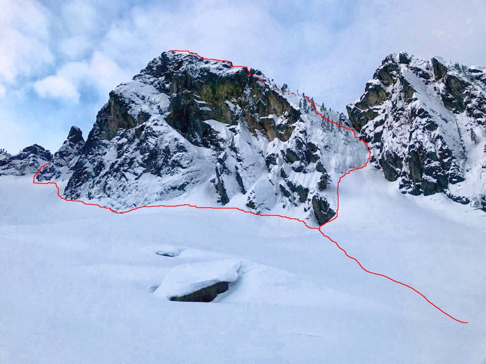
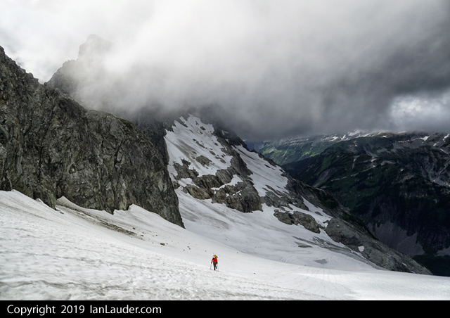
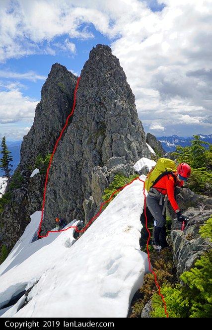
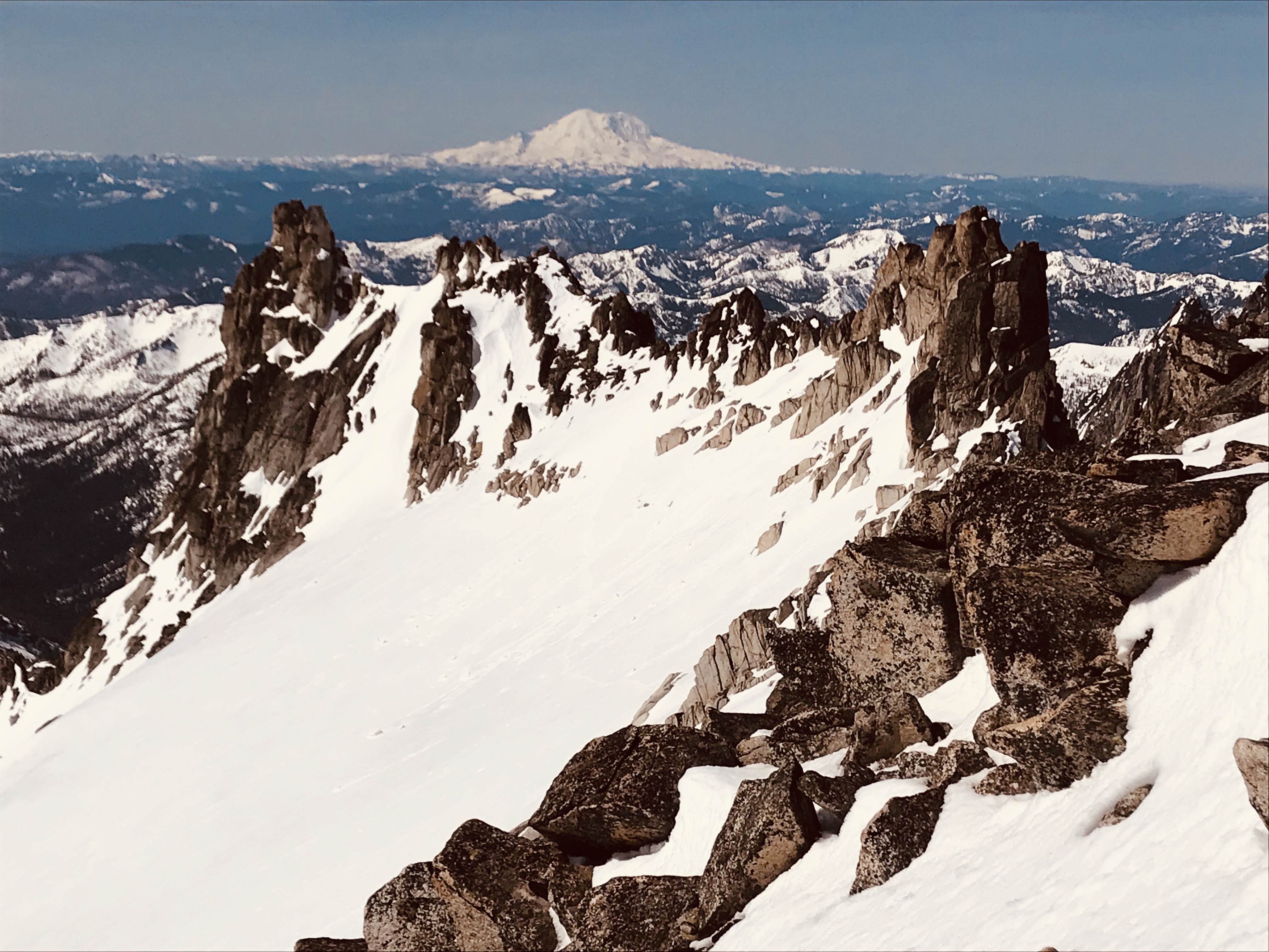
Trip: Mount Formidable - South Route
Trip Date: 07/05/2020
Trip Report:YouTube video (FYI - mistyped the date in the video splash screen - its July 4-6, not June)
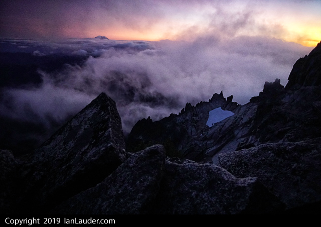
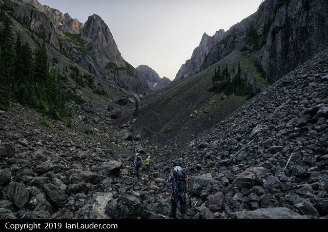
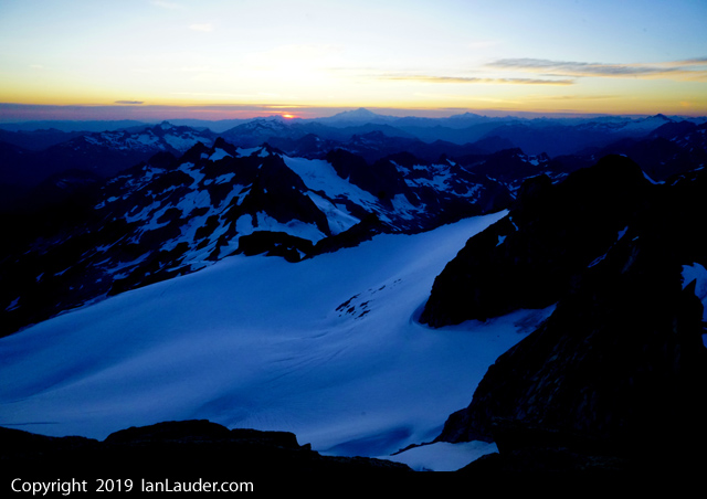
We had a Fri-Sun trip planned but switched to Sat-Mon due to the weather. Good call as one day either way would have been a no-go. We lucked out with the one day with sunny and calm weather for the summit day.
Overall it was about 26 miles and pushing 10,000ft gain for the whole thing car to car. About 7 hours to camp, 19 hours for the climb day and 6 hours hike out. The climb day broke down to about 2.5 hours from camp to the col looking at Formidable. 5 hours col to summit, 8 hours summit to col (extra time due to an additional handline, softer snow coming down and rappels for 5 people), 3.5 hours col to camp.
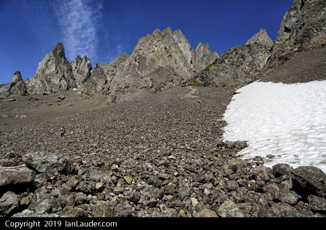
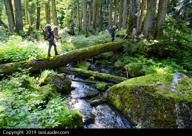
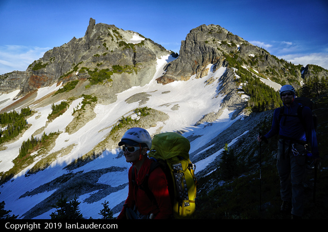
5 of us took off from the gate 2 miles back from the Cascade Pass trailhead adding an extra 4 miles and 1000ft gain to the trip starting around 8:30am.
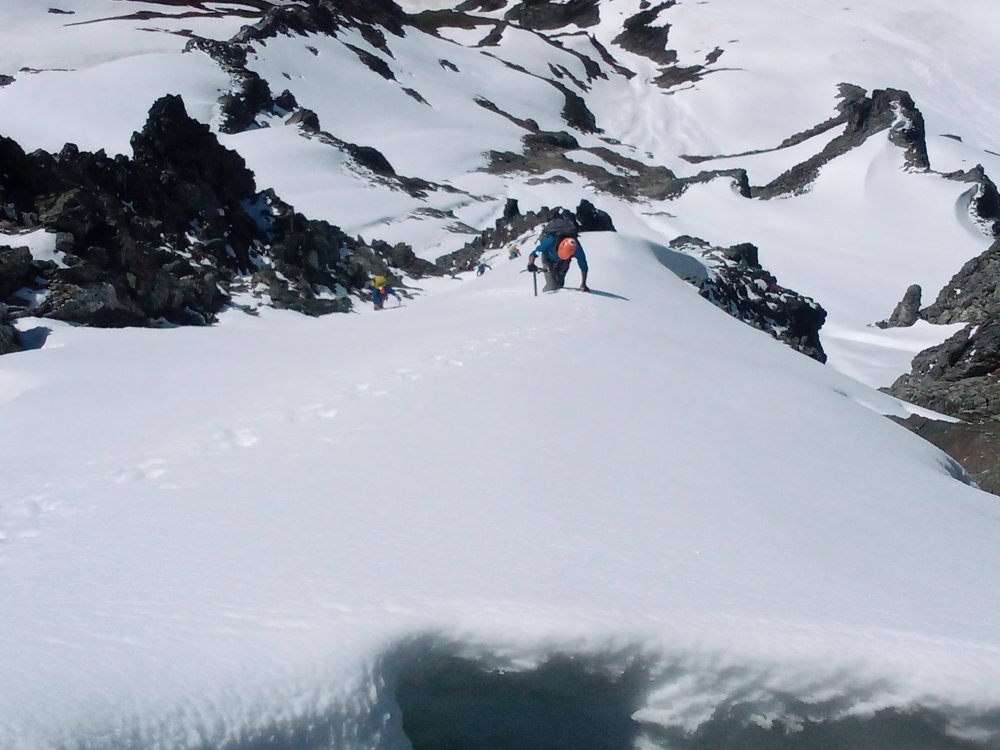
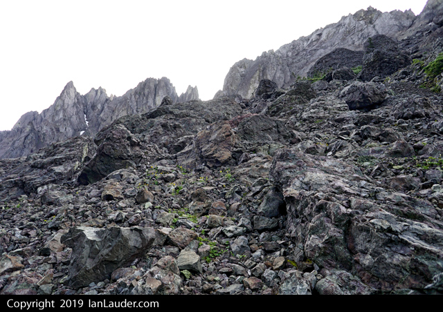
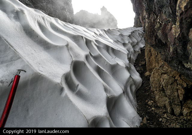
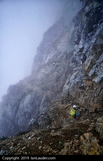
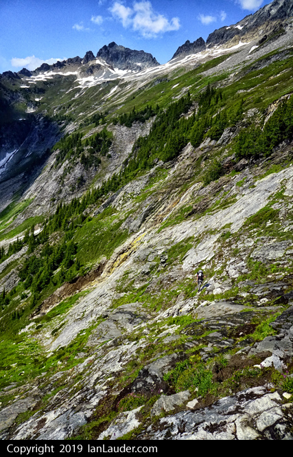
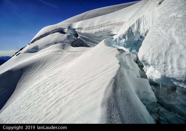
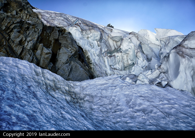
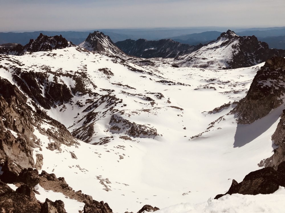
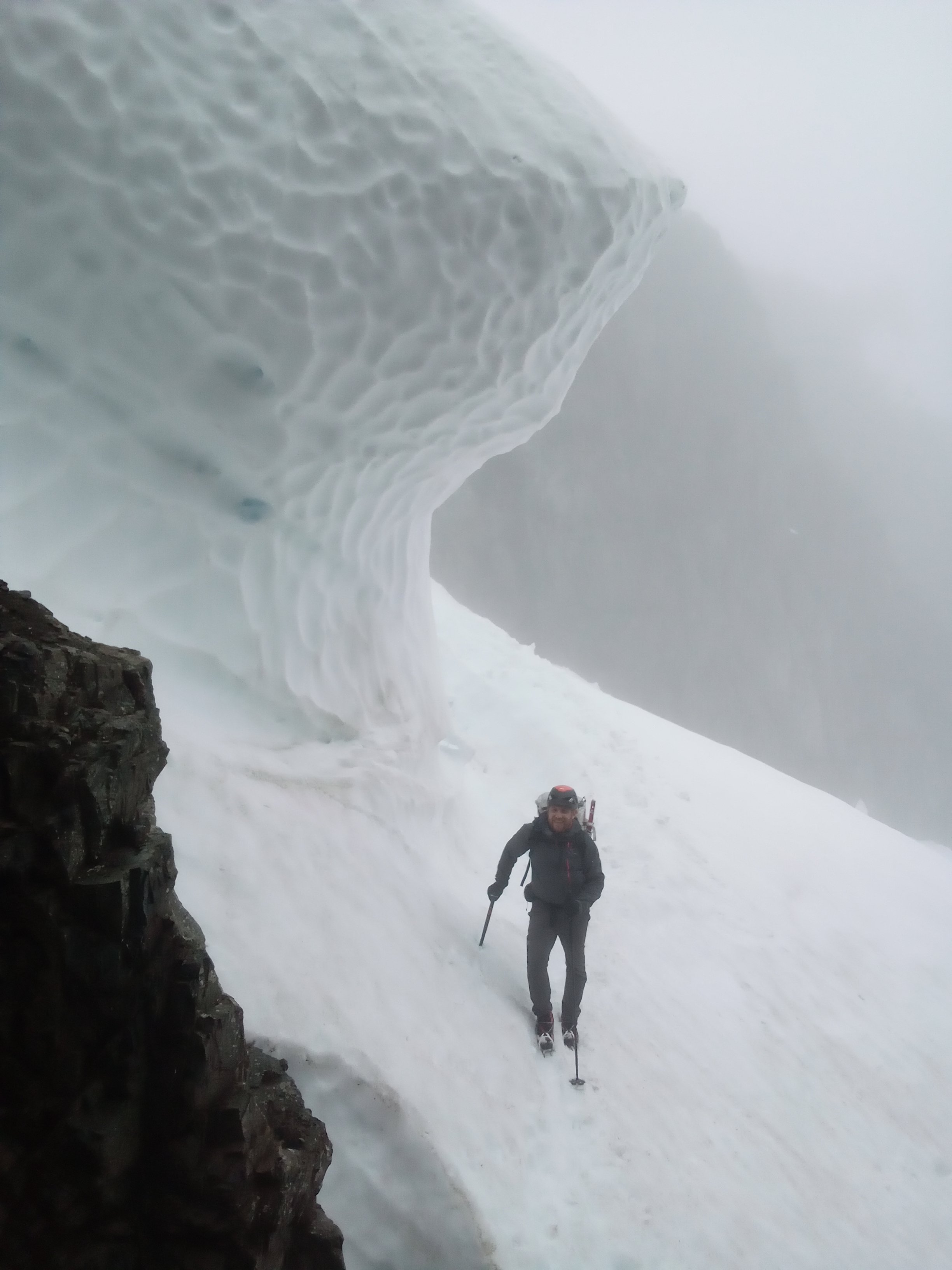
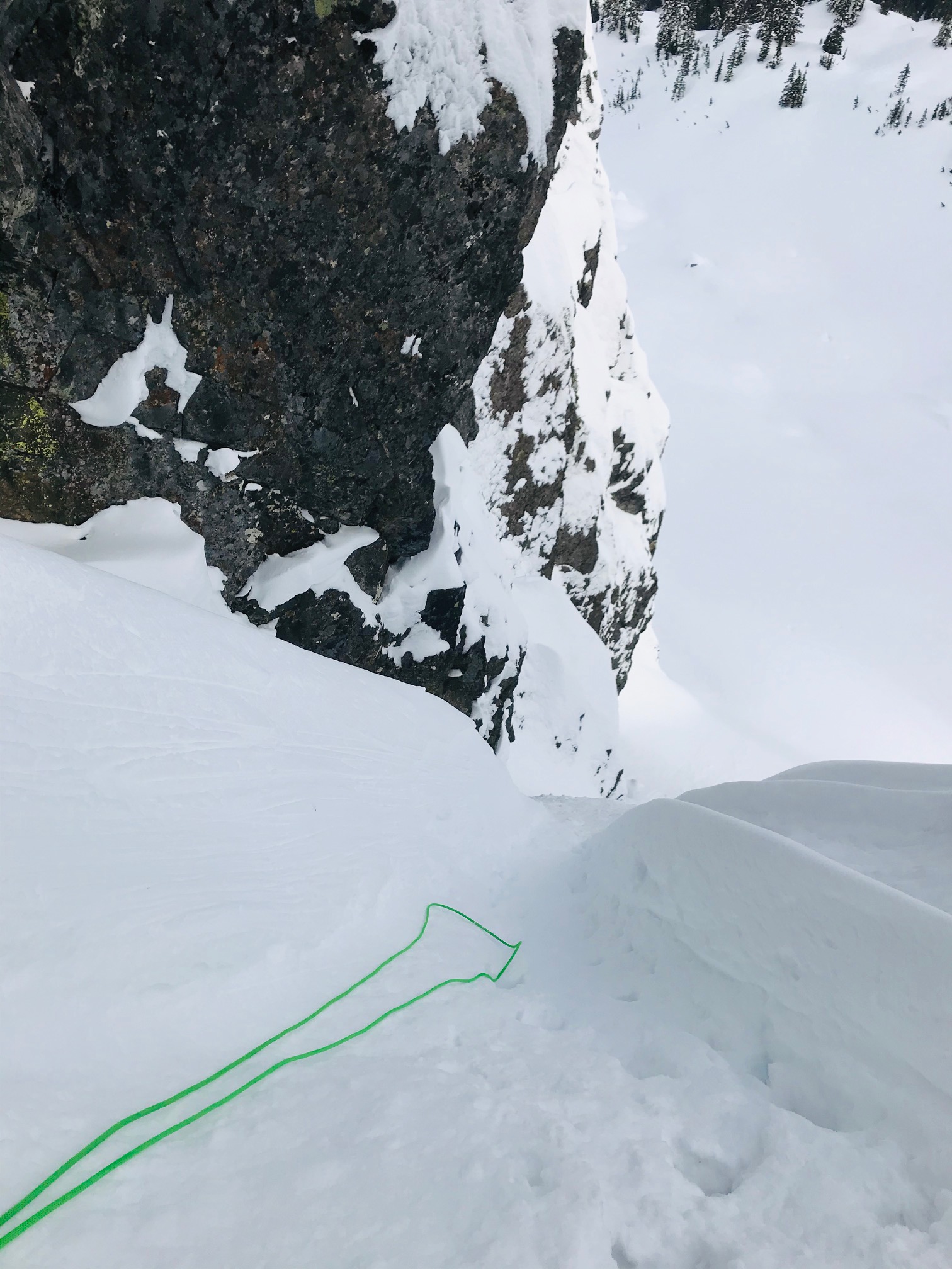
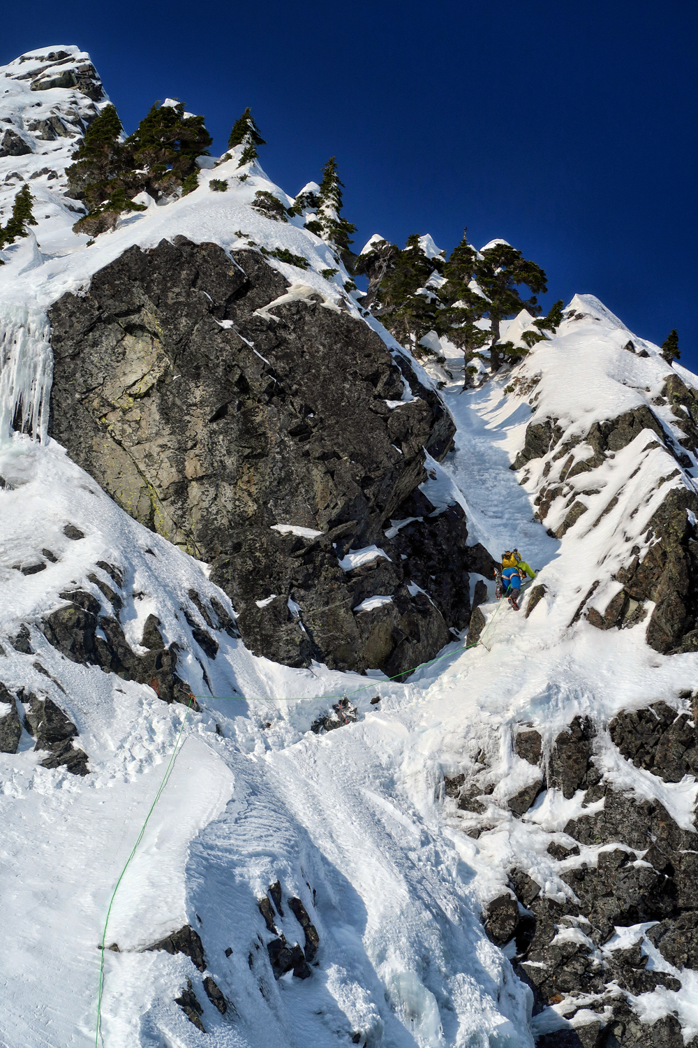
From Cascade Pass 99% of the rest of the trip was on snow with only an occasional bit of trail or rock islands to cross. Steep snow with bad runout in places along the way to Cache Glacier but not bad. There is a huge cornice forming across the entire width of Cache Col. That will not be pretty when it collapses. We had to hit it on the far right and traverse under the cornice to the rocks on the other side and a loose scree/rock scramble up to the top of the col.

From there its an easy snow walk to Kool-aid lake which is still under feet of snow. But the water is running at the stream there.
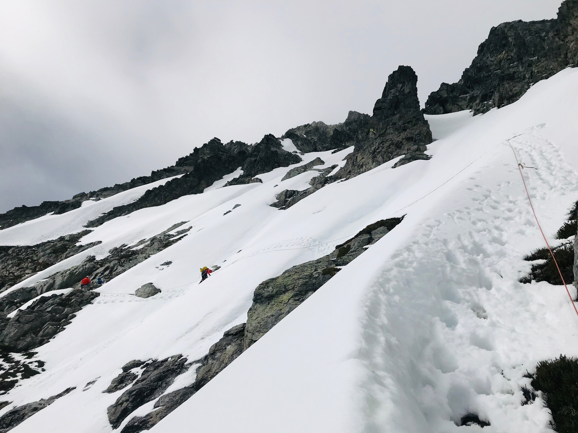
The traverse around to Red Ledges is also an easy snow walk the entire way.
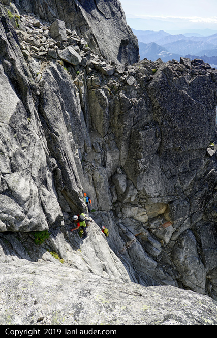
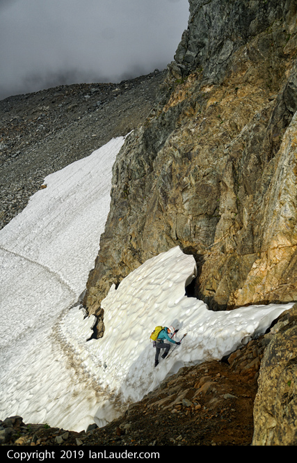
The Red Ledges were a bit tricky. Getting onto them is straightforward traversing on steep snow but the last bit is a runout over the moat. Around the corner out of sight was another steep now patch about 20ft across covering the ledge with runout into the chasm that had to be side traversed. Then a steep snow climb out of the ledges, again with runout into the chasm. Everyone soloed it okay but its 3 no-fall steep snow sections to get through the ledges.
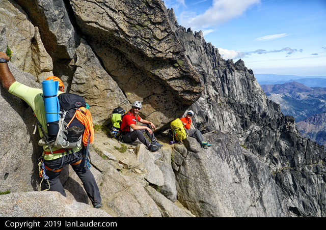
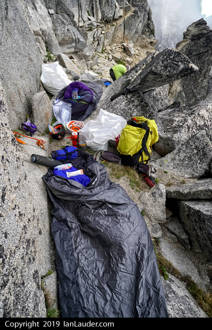
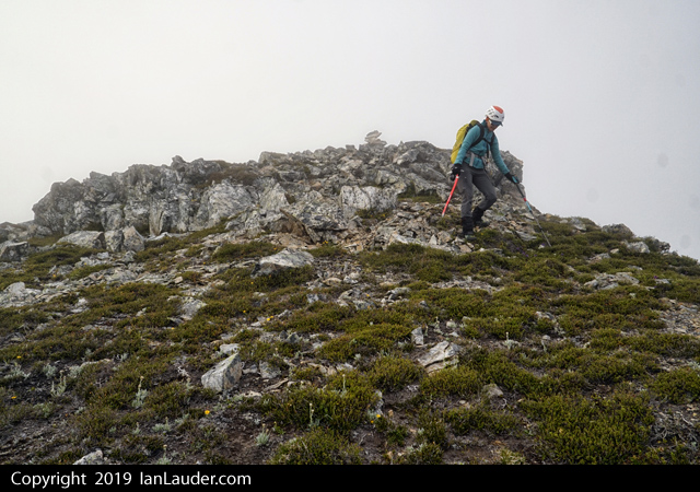
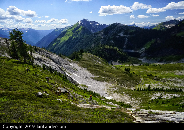
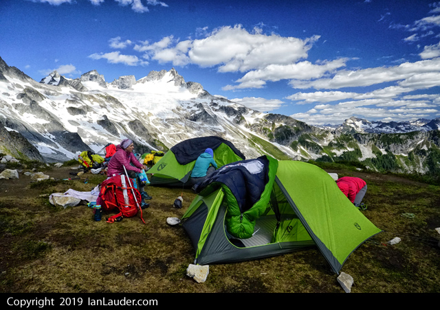
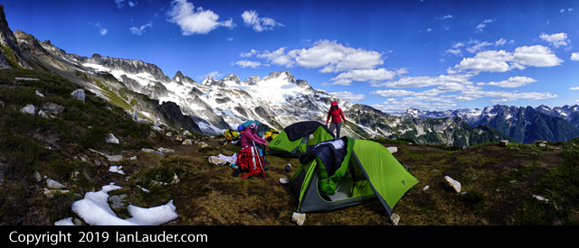
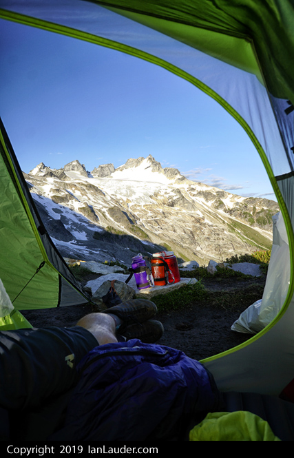
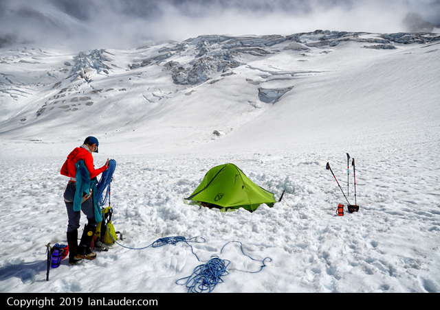
We setup camp just around the corner near Arts Knoll and turned in early.
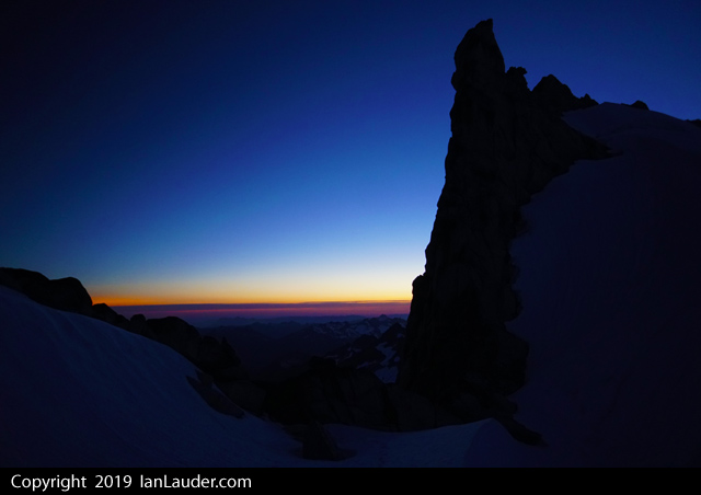
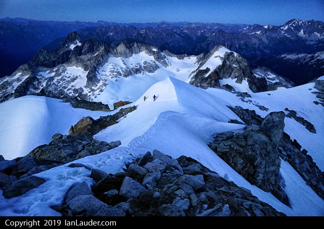
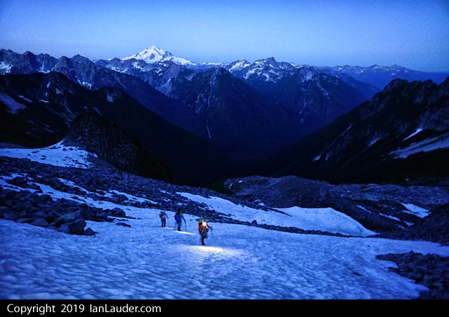
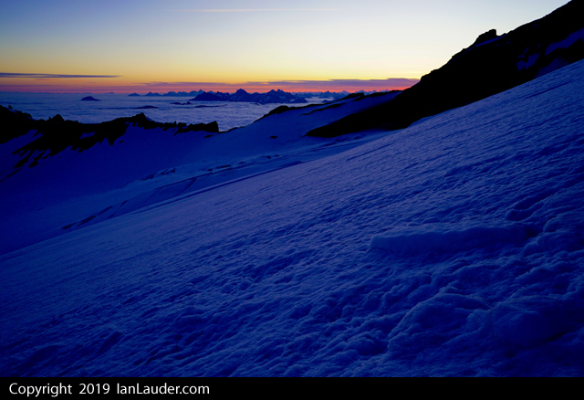
3:30am wakeup and walking around 4:45. We woke up to clear blue sky and calm weather.
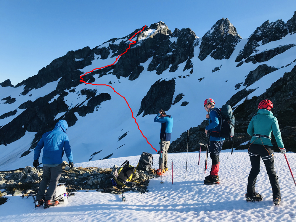
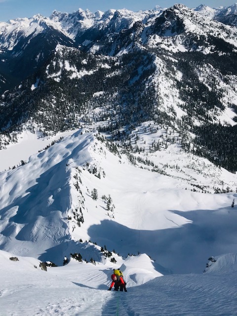
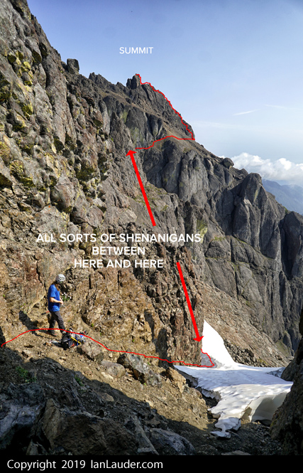
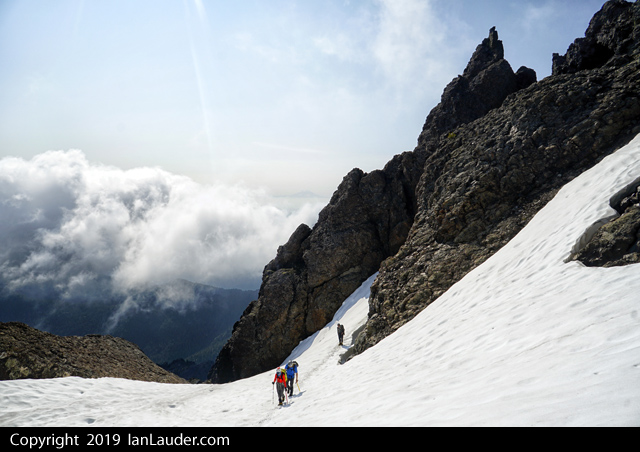
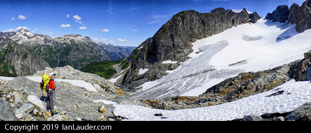
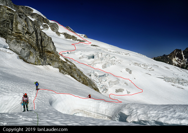
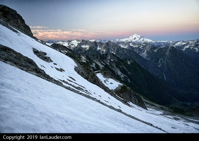
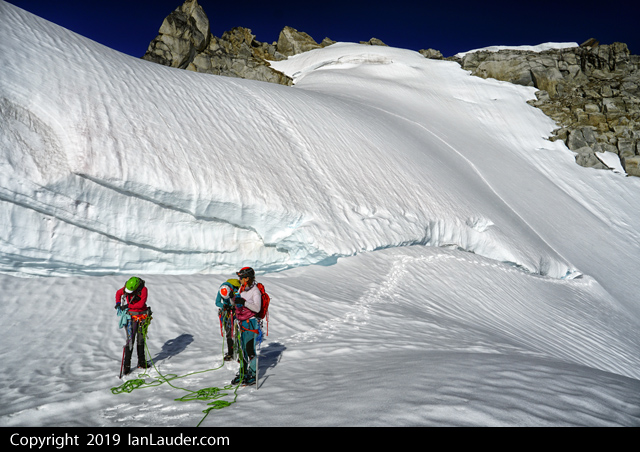
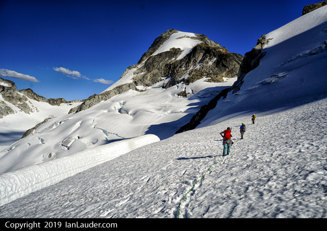
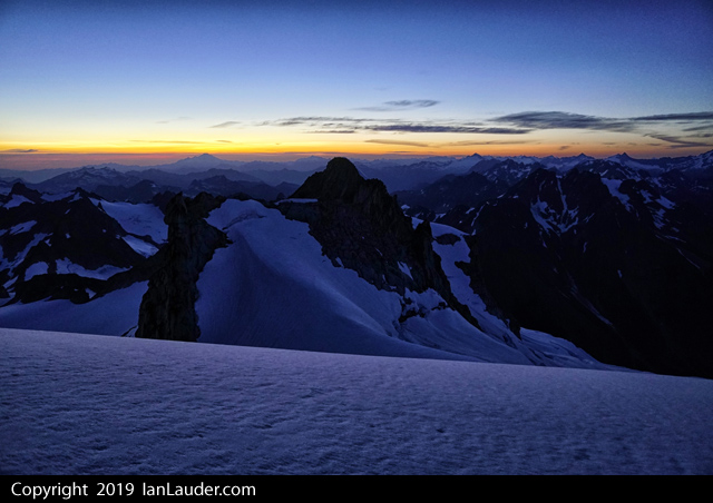
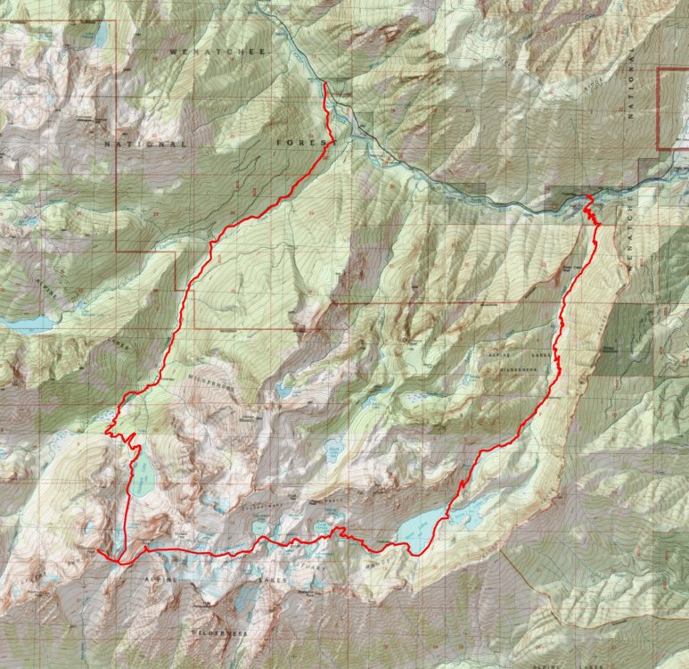
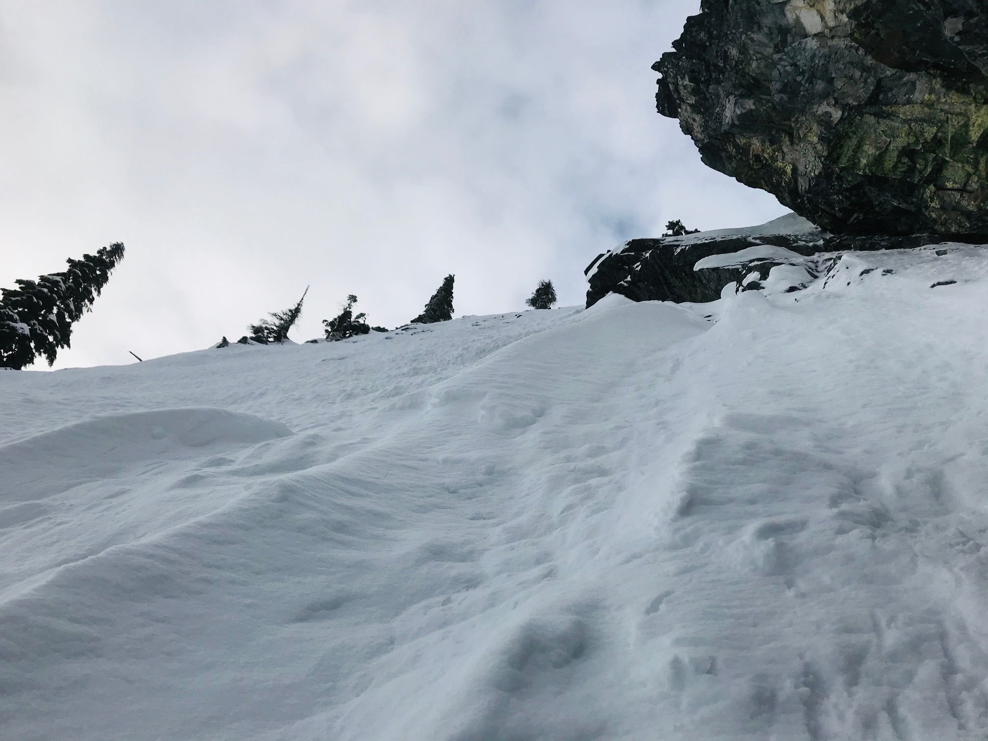
Made quick work of the Cascade Glacier, down Formidable/Spider col and across the basin to the final col in just over 2 hours.
The drop from there was on a steep snow finger that was easy to get down. From there a walk across and backup to the rock ledge where we found a couple different paths to scramble up the ledges to the next snowfield.
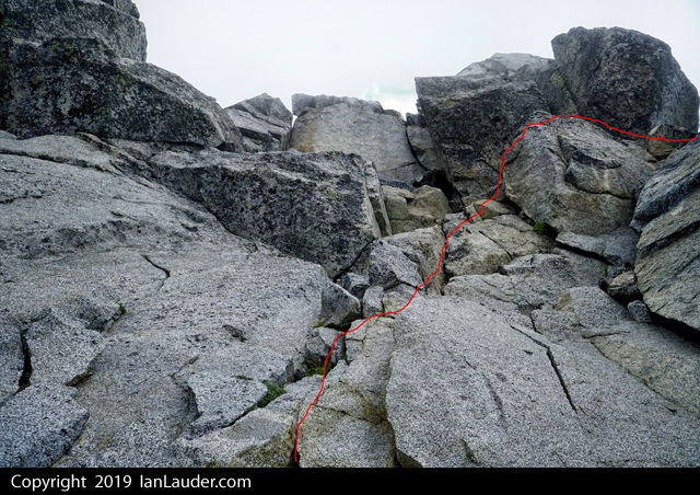
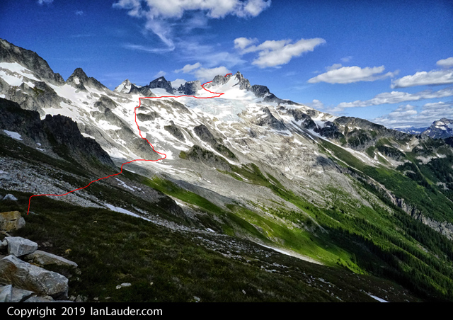
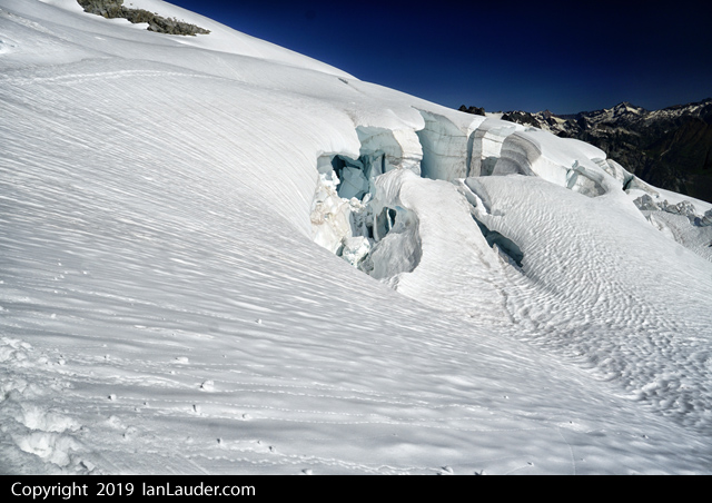
From there we went up to where the ledges scramble option starts but looking at our options figured there were too many snow patches on the ledges but it looked like snow went all the way up the chasm.
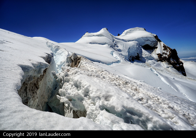
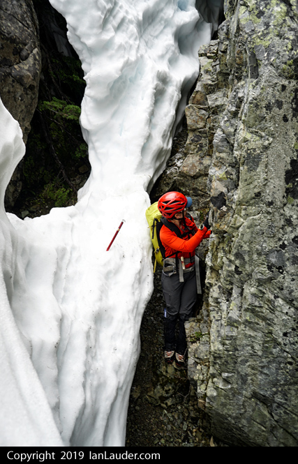
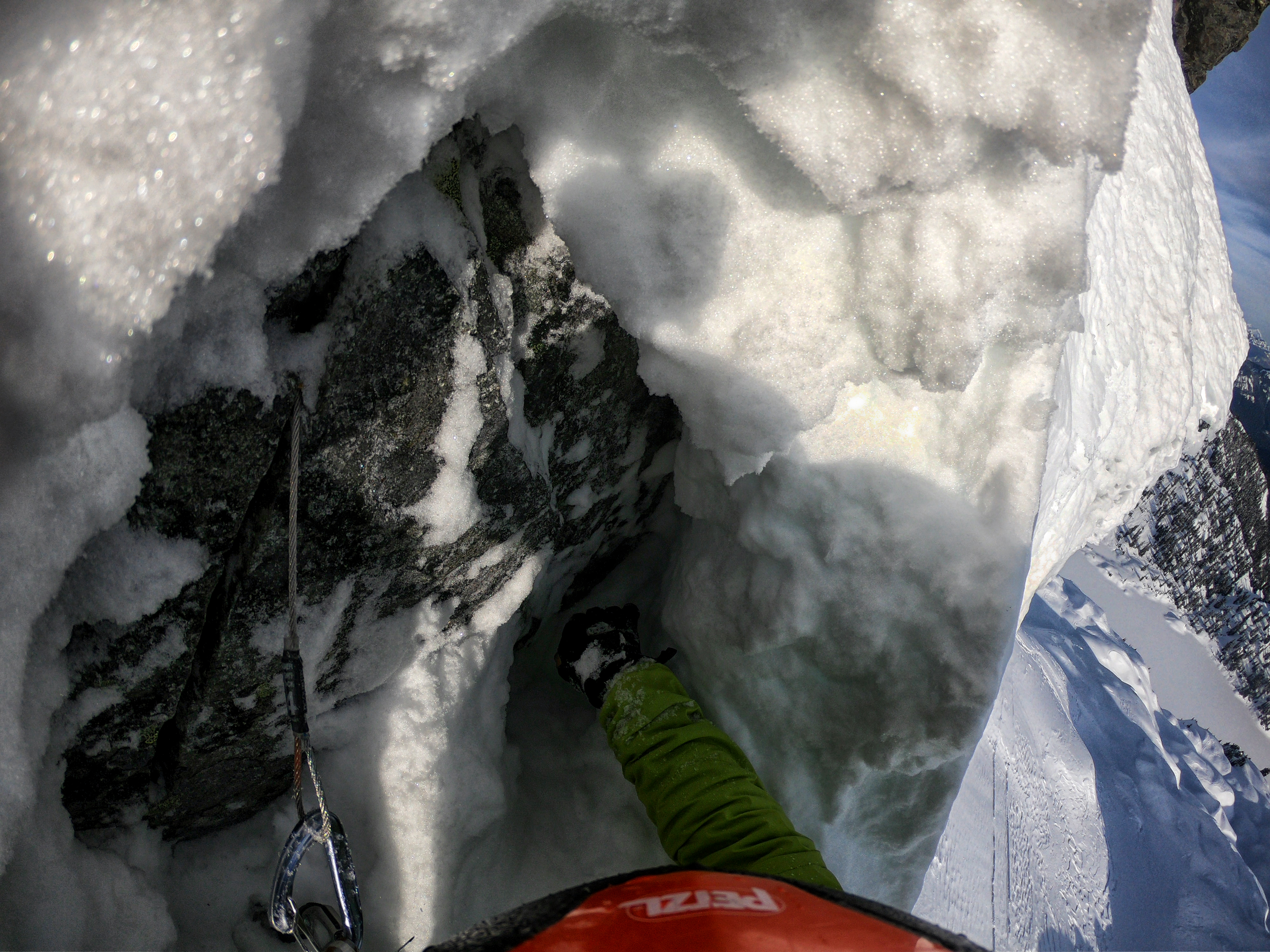
So we decided to go straight up the middle of the chasm hoping to intersect the 4th class step across the chasm. Halfway up we hit a moat starting to form but was still enough left we were able to get around it and all the way to where we could step onto the other side of the chasm. The ledges had a layer of snow and ice but was easy to get into and made it to the cairn.
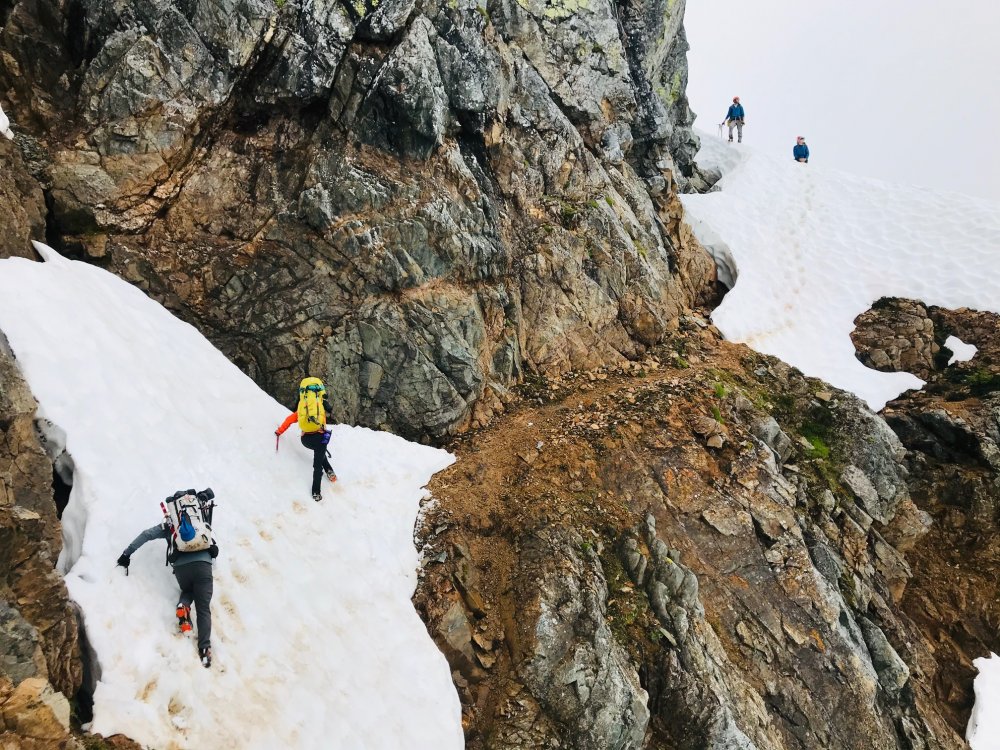
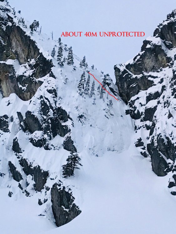
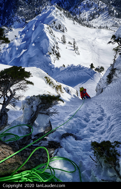
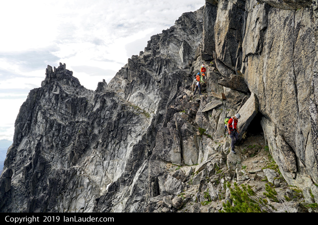
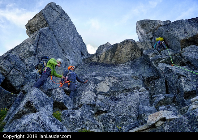
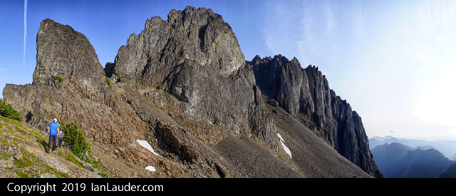
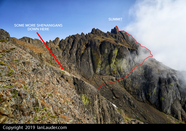
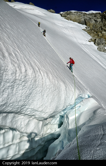
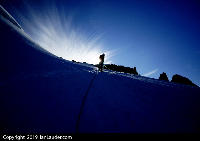
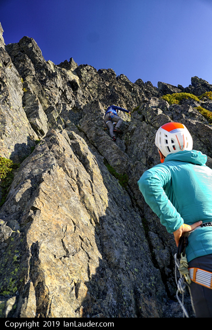
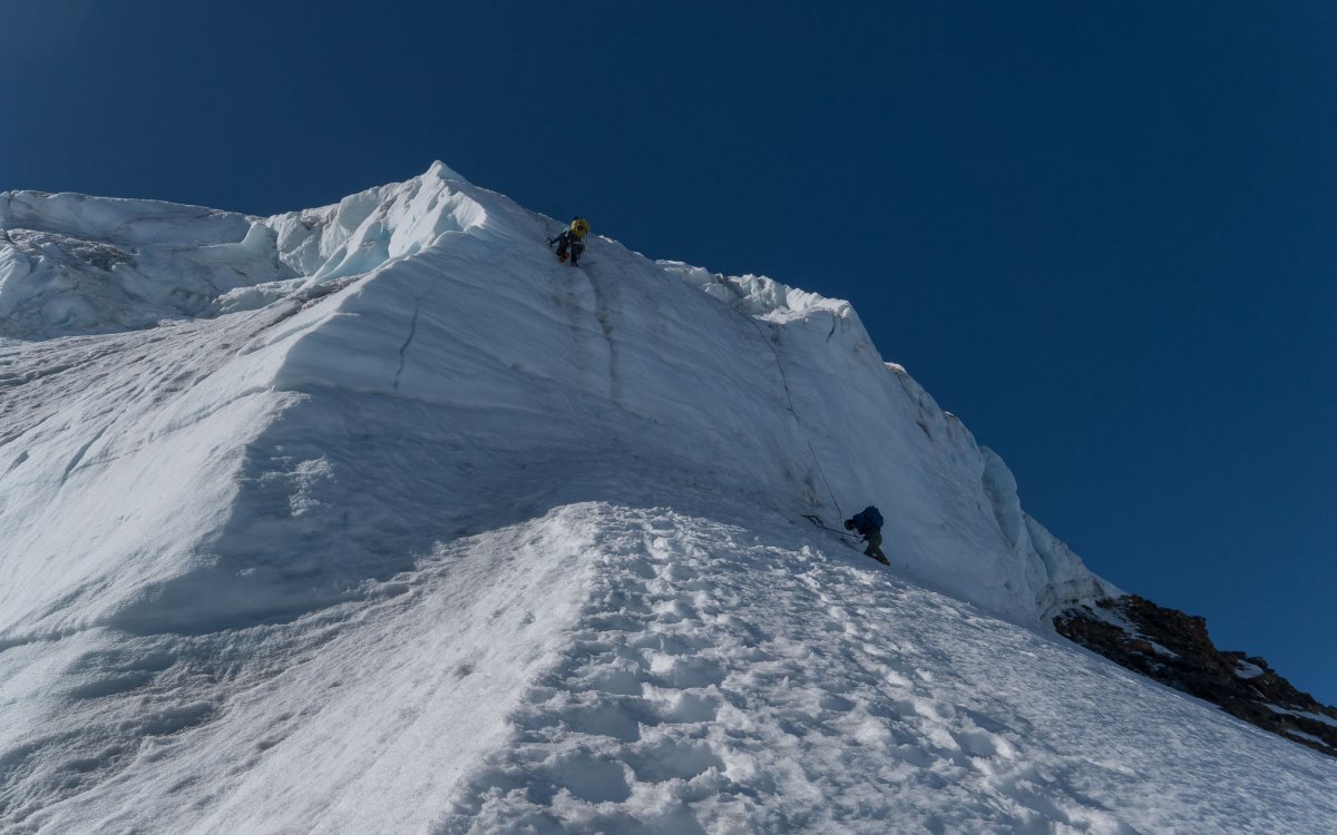
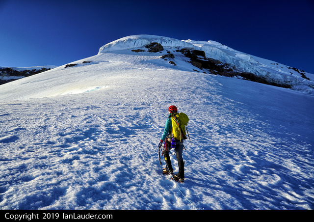
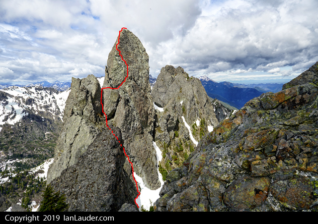
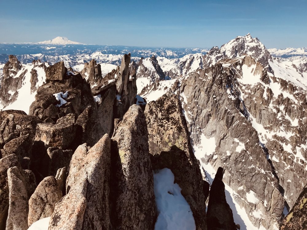
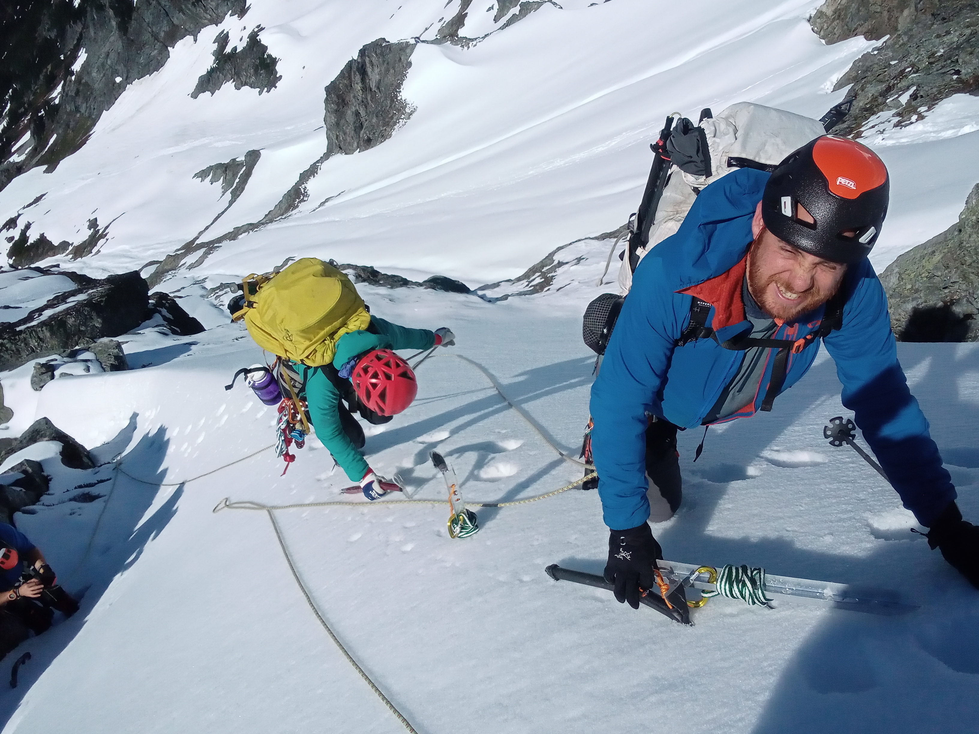
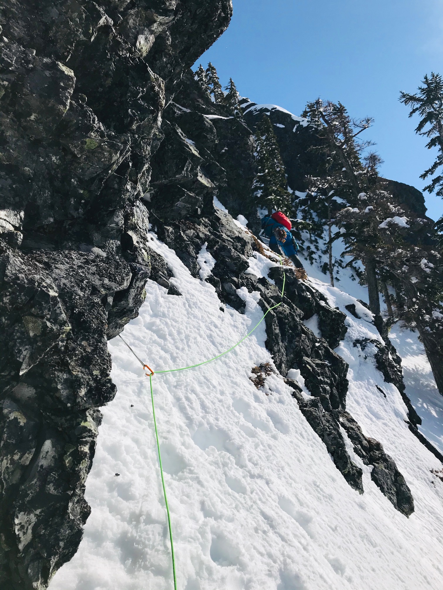
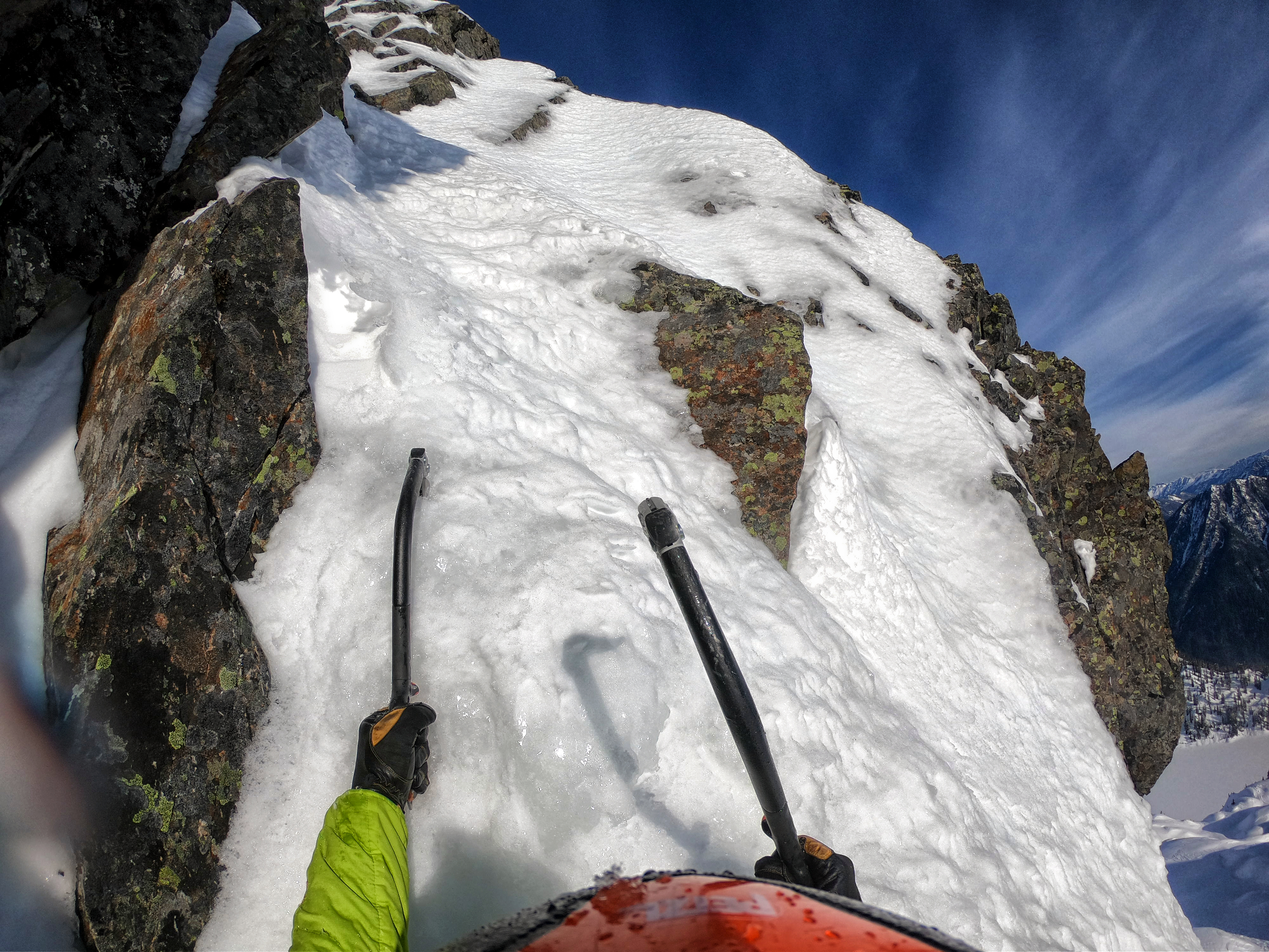
From there the next trick was getting across the face which was mostly steep snow. We started going up about 40ft before starting to traverse over.
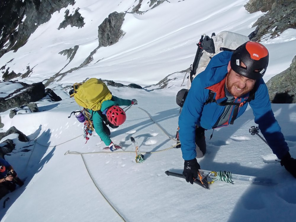
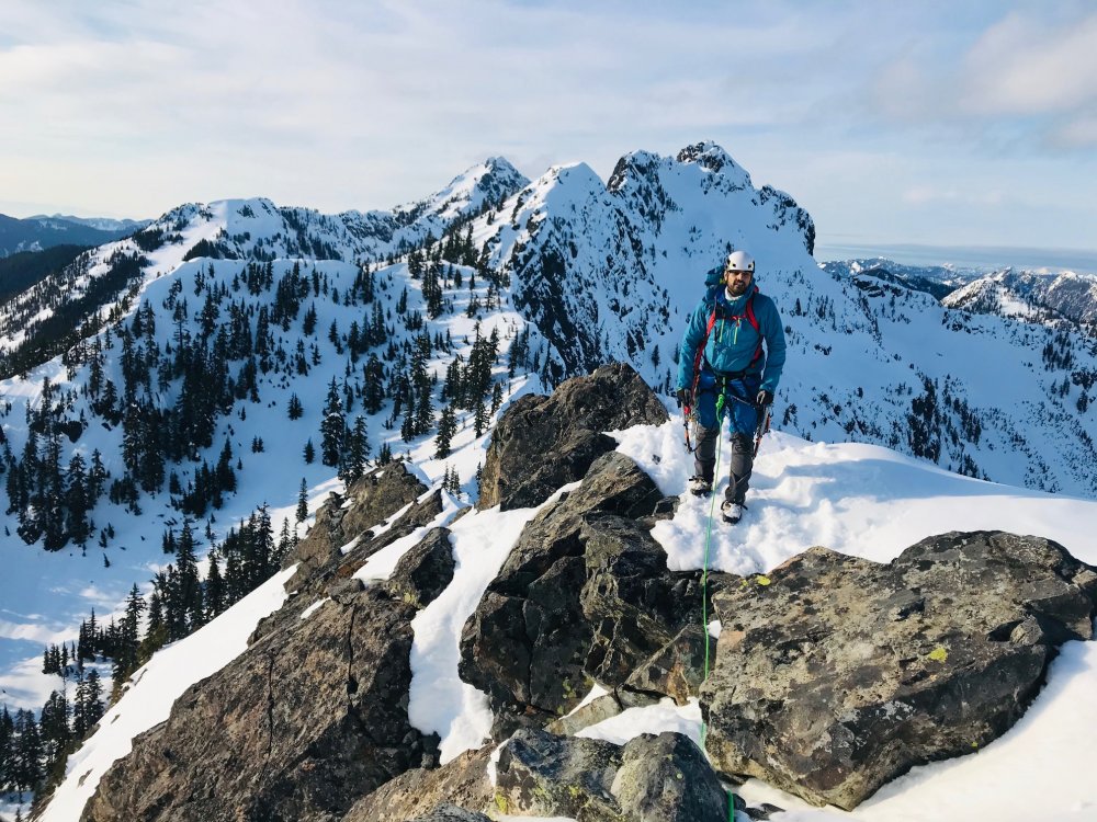
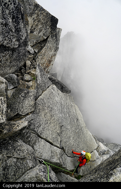
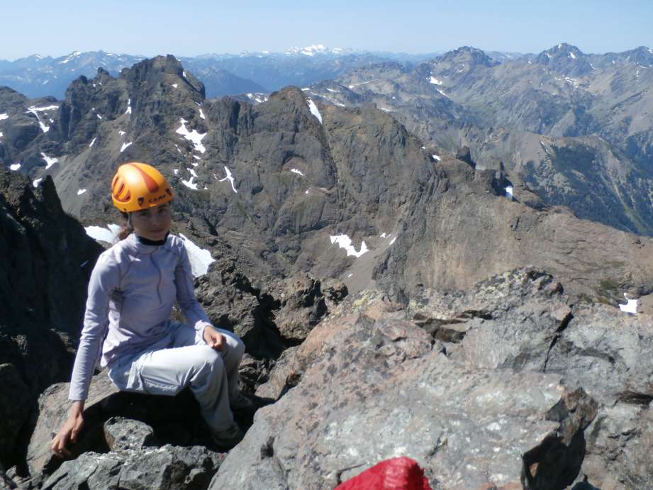
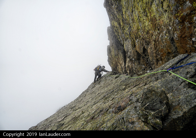
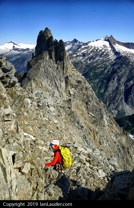
(Photo of Albert, Rodica and I by Tim)
One person was far enough out they soloed across to the rock island. The rest of us decided to run a handline so we got one anchored to rocks on both ends tying our twin 37m ropes together. Once across the first half we had a 2nd snow slope to get the rest of the way over so we repeated with a 2nd handline between two rock islands. The snow was firm enough on the way across we sped it up having more than one go across the handline at the same time. On the return trip with softer snow things slowed down when we only sent one person at a time across the handlines.
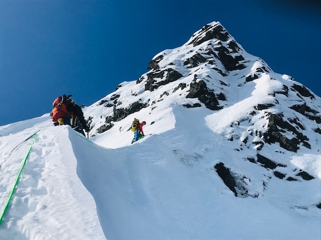
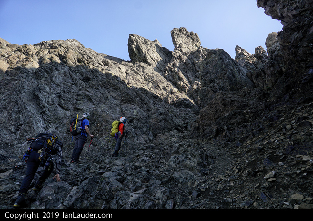
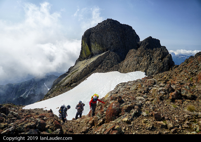
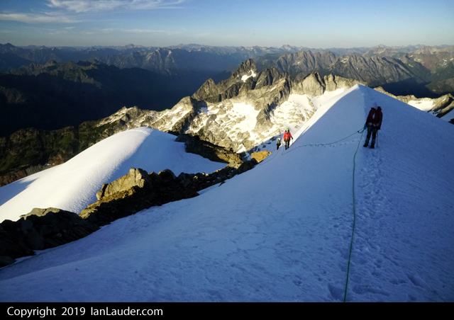
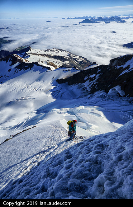
Once over we had the last 300ft most of which was another steep snow slope which was starting to soften up.
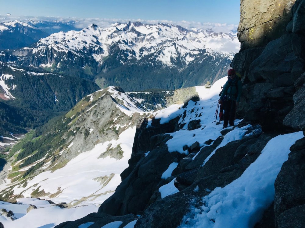
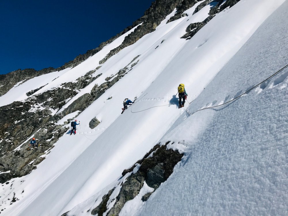
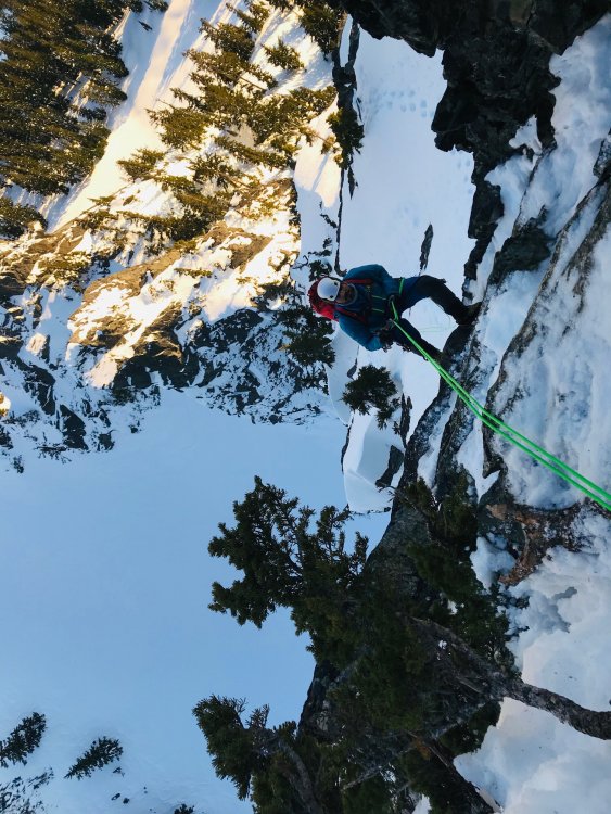
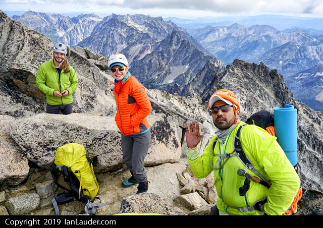
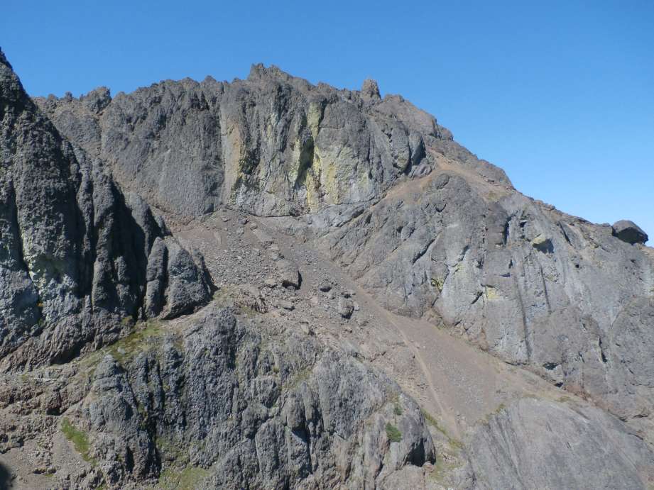
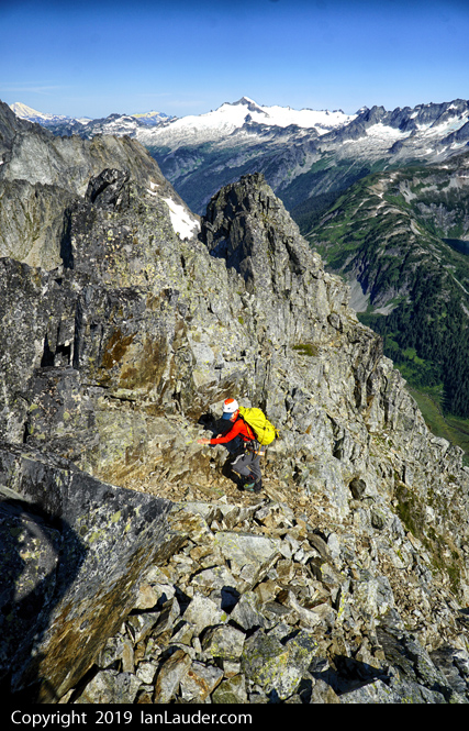
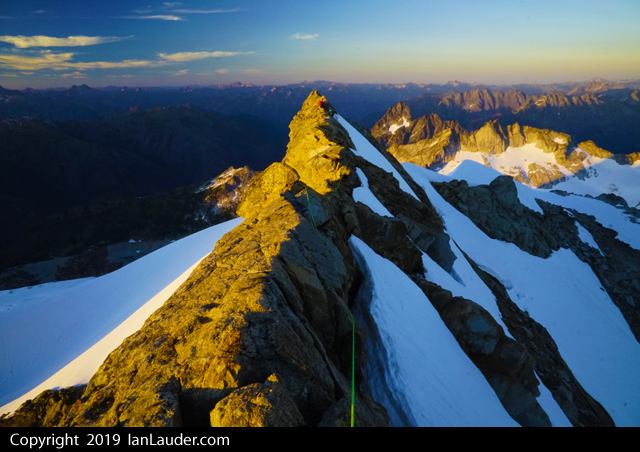
(Photo of Sean, myself, Rodica and Albert coming up the last 250ft snowfield from the base of the traverse to just below the summit block by Tim).
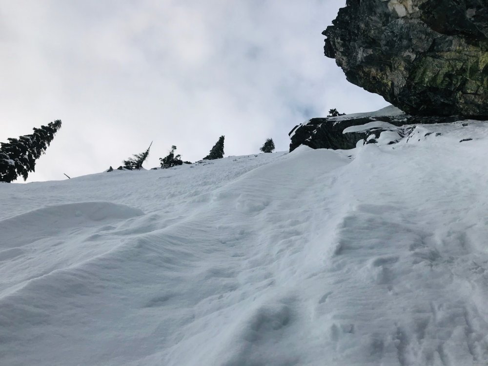
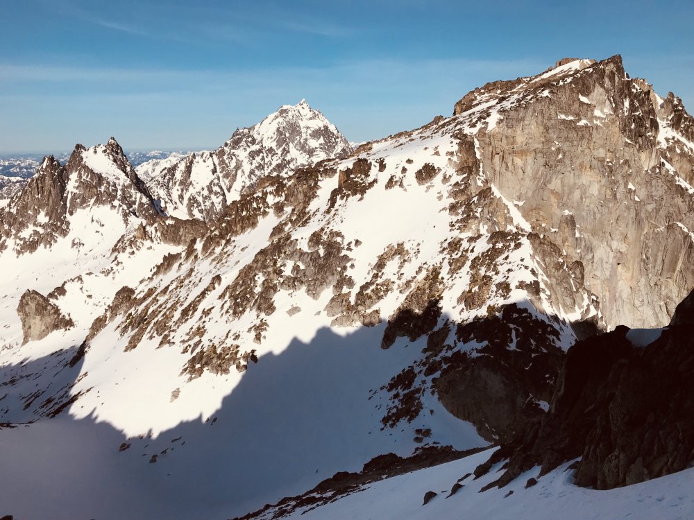
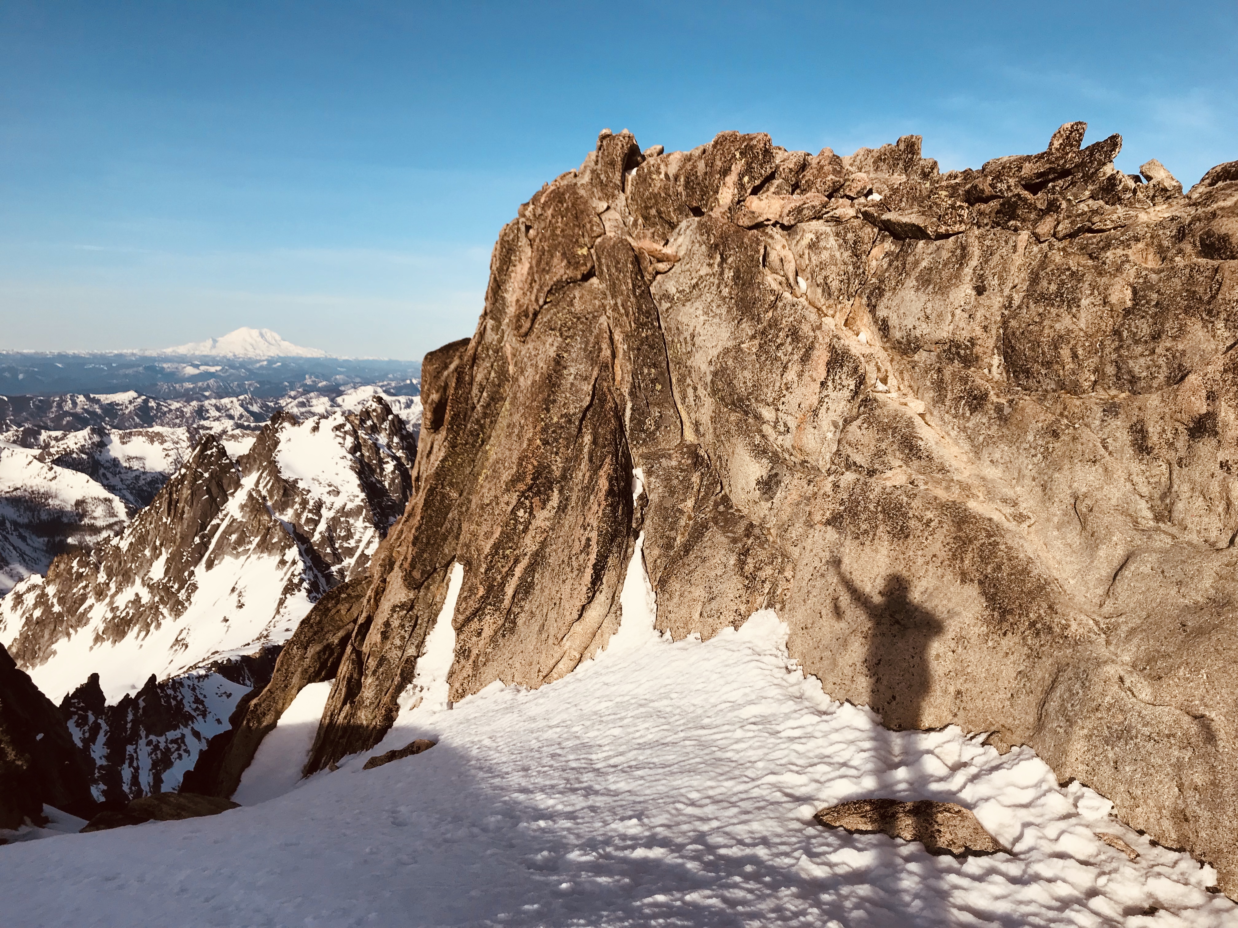
We were able to all solo up and then the last 50 feet or so to the summit block was mixed snow and loose rock.
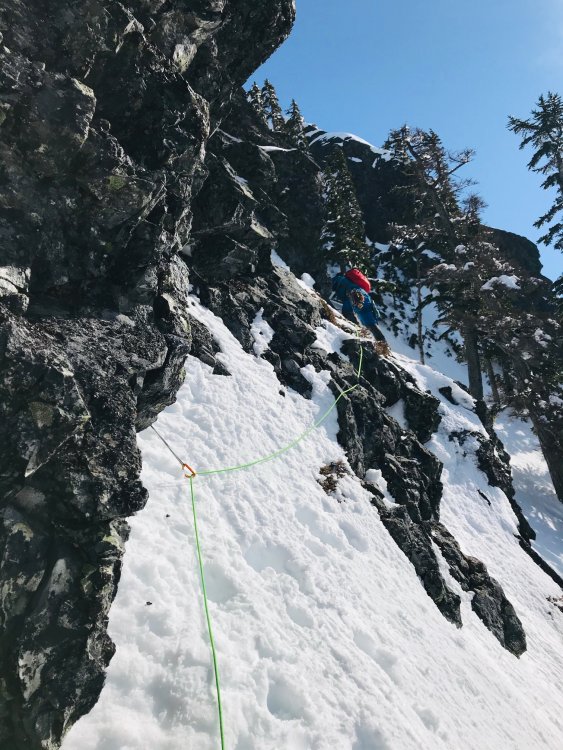
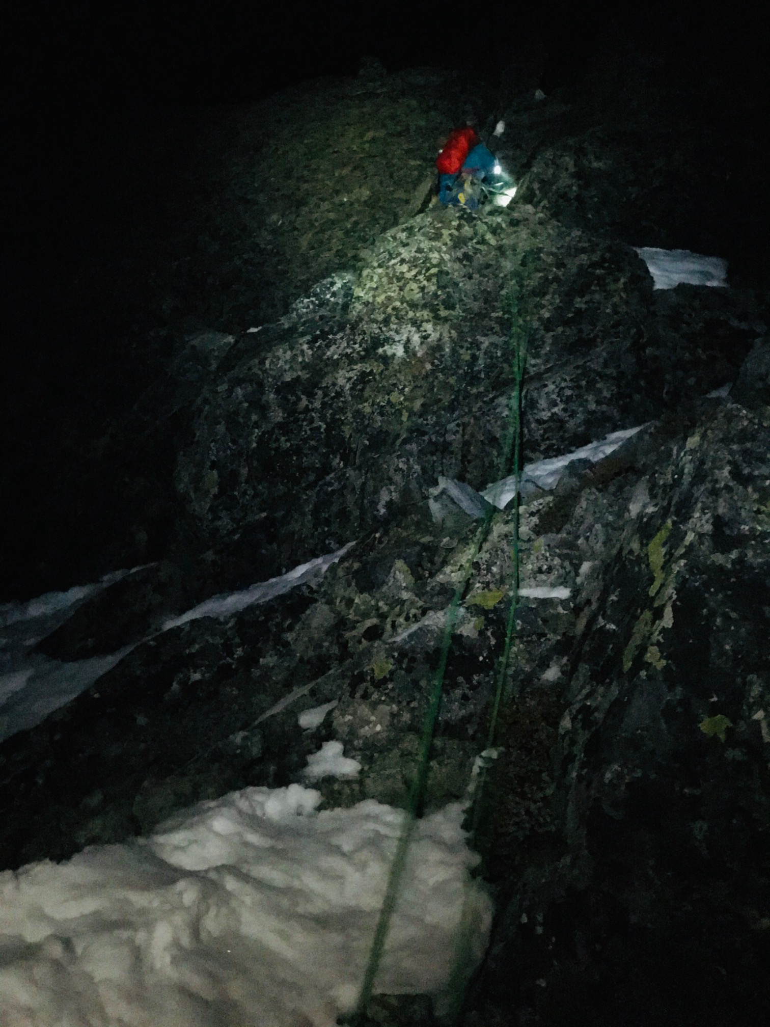
On the way down we scrambled the rocks about half way down till we found a horn that seemed like it would hold a handline and backed it up with a cam and dropped down the rope as a handline for everyone to prussic down to the start of the traverse. Last person cleaned the gear and downclimbed with a couple pickets left in to protect the last person down.
To get across the face we repeated the 2 handlines to the cairn at the top of the chasm. With the softer snow on the way back only one at a time went a cross each handline. That and dropping a line to prussic down part of the upper snowfield from the summit block and the rappel added a few extra hours to the trip down.

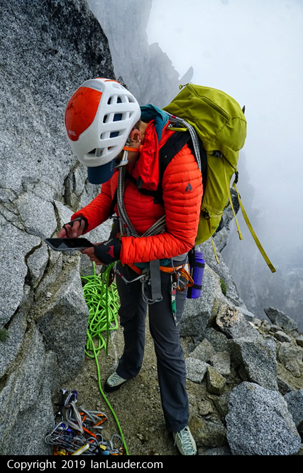
Here we couldn’t find any rappel slings from other videos we’ve seen. Maybe they were still buried under the snow. So we tied 3 cordelletes together and slung the giant block the cairn is sitting on as a backup to rappel slings put around 2 smaller boulders. We rappelled off the smaller boulders with the backup in place in case they moved. The last person down retrieved the cordelletes and just left a sling behind. So, if anyone ever sees that sling wondering if someone rapped off the small boulders – it was backed up for the first 4 people.

That rappel put us down past the moat forming in the middle. And had to jump across the side moat to get back onto the snow. From there a short face in downclimb and then back to the scramble down the ledges.
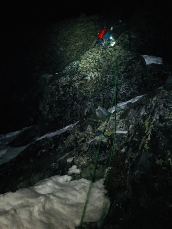
By the time we hit Formidable/Spider col the sun was going down and headlamps came out. One person had a headlamp bulb go out so we had to slow down on the descent of the glacier and back to camp which added the extra hour on the return to camp.
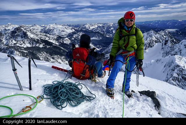
Great climb with a great group that worked well together figuring out some tricky options to protecting the climb in ways that are not normally done there that way.
Signing the summit register the last people to have signed it were almost a year ago last August.
Memorable Quotes Gathered by Sean:
"We're crazy" ~ Rodica"Is that the Spider/Formidable col?" ~ Albert, deliriously pointing toward a snow finger nowhere near our exit col"I have some cord that I found and don't know the history of so we should rap off it because i'm tired of thinking about it, I just want to get rid of it" ~ Tim"Guys, we should really be protecting this. Right???" ~ Rodica"I don't mind if we bail on this picket because it's Albert's anyway...." ~ Ian
"If I hike all night and go straight to work I probably still won't make it on time" ~ Sean
"I'd love to come up here in tennis shoes sometime" ~ Tim
"Would you consider this an intermediate climb?" ~ Albert
"These are all the cams left?" ~ Ian
"[ice axe falls down cliff]" ~ Ian
"[glove falls down cliff]" ~ Sean
[Blue Skies by Ella Fitzgerald comes on the radio when we're in a whiteout at camp] "I think the radio is taunting us" ~ Tim
"I'm already committed." ~ Sean, as everyone else decides to stop and rope up.Gear Notes:
Twin 37m ropes, light alpine rack (cams/nuts), 5 pickets, ice axes + 2nd tool
-
 1
1
-
 1
1
-
-
I did really enjoy it overall despite feeling really hung out there by the time I was halfway across the traverse with only small footholds in a thin crust. I was eyeing that dihedral but wasn't sure about it, and once I started across the traverse I didn't want to backtrack.
-
Trip: The Tooth - NE Slabs
Trip Date: 02/27/2020
Trip Report:I’d heard of the ice route on The Tooth over the years and had always wanted to do it.
Originally, we had a party of 4 which turned into a party of 2. In hindsight that was for the better in the end (see Pitch #2 below). Adding one person for a party of 3 or 2 teams of 2 would have added too many extra hours to the day. And everyone would have had to be okay with (see Pitch #2 below).
I put 40m in the pic but it may be more like 30m for the distance between the stubby tree and the BD spector.
After having done Chair Peak the week before we figured we would have similar snow conditions (lots of fresh new snow for most of the route with some buried ice). But knowing the slabs were 50-70 degrees were not sure how much would have held on those slopes.
We had some beta from Jim Nelsons book and some trip reports which were few and far between. Most talked about (see Pitch #2 below).
We had a good weather and avi window for about one day this week, so we decided to take a run at it mid-week.
3am alarm. Set off all the smoke alarms in the condo burning my breakfast sandwich (Nest app wouldn’t load fast enough to silence the alarms). It was a really good breakfast sandwich too, burnt cheese adds a nice flavor.
Pick up my climbing partner at 4am, and we’re hiking in from the Alpental trailhead by 5:10am.
Decided to stash poles and snowshoes at the base of the fan a couple hundred feet from the start. Turned out snow was good for a boot path up the fan and made a belay anchor with a horizontal deadman off to the left of the 1st pitch.
My partner led up the first pitch. I called out where to look for pro placements in the rocks from where I saw them in previous reports, he didn’t find any. Just pounded in a couple pickets on the way up. No ice to be found for screws. We ended the first pitch maybe 20ft below the “belay alcove” mentioned in other beta with a nice 3pt anchor in the rocks.

From there I started up Pitch #2 which I had read about could be runout without much in the way of pro. One trip report had mentioned 30ft of runout. If you ever read that beta just change 30ft to 30m.
Got a nice cam in right above the anchor. Instead of starting the traverse I decided to go straight up to where it would normally start and had to carve my way through a snow flute all the way up since it had the best footsteps I could find. Not much in the way of ice, and what little there was turned out to be kind of brittle. About 20ft up and off to the left of where the alcove should be dug out a rock and lucked out that it had a crack for small cam then a few feet away another nice place to slot in and set a BD Specter (basically a piton shaped like an ice axe pick).
Then it was time for the meat of Pitch #2. Looking across and up at a couple stubby trees I could make out a red webbing anchor and it looked like a bit of a break in the steepness on the way (which was still in the 50-60 degree range). So, I headed up and over one painstakingly slow step at a time. Keeping my weight over each tool pushed into snow and one foot as equally as possible gingerly kicked in each new boot step. Sometimes I got a good step kicked in sometimes it was just a toe. Never had solid tool placements. Any stick attempts just bounced off rock up high but was able to push the heads in and down into snow enough they would hold. An hour later let out a whoop when I got a sling around the first small snag about maybe a 3rd to a half rope pitch away. Then an easy section straight up to a big belay tree. And having monopoint crampons for the mixed sections (which wasn’t really necessary in the end) didn’t help with the traverse.
So, Pitch #2 was a long 30m traverse across a 50-60 degree sketchy slab with no pro at all till the spector about 20ft above the belay behind me. This is the crux of the climb and the snow/ice coverage is the determining factor if the climb is doable or not. And anyone leading it should be comfortable with a runout traverse. A follower still has to deal with an unprotected traverse but at least may have a bootpath to follow in.
After that mental ordeal Pitch #3 was more straight forward. Other beta says to go up to a tree on the ridge but the coverage on the slabs got too thin so I went right have popped over the ridge at a small notch in the rock that just needed a mixed move to get over.
Pitch #4 was some mixed moves across easy mixed snow and rock (you could make it easier by dropping even lower and walking down and then back up in a snow field). We stayed high then moved over to some big trees and up to a tree for the belay.
Pitch #5 was straight up back onto the ridge proper and to short rock block ~10ft high) that took some easy mixed moves. Once on top of that you can lower down into the notch to a belay tree.
Pitch #6 was the 15ft rock step in other beta. This took some easy mixed moves finding hooks in the rocks and snow/marginal ice) and back on the ridge proper to a giant block (it happened to have a cordallete around it). Lowered down this to another notch and setup a belay. This was a really short pitch due to rope drag through the snow.
Pitch #7 walked around the corner of this notch and you can see the summit block which is a full 70m pitch away of easy traversing and a few easy mixed moves.
By 4:30 pm we reached the summit (about 7.5 hrs for the pitched climbing).
After some much needed food we looked over the snow covered edge and realized we should rappel to what normally would be the 1st rap station going down the basic south route).
4 more raps later and in the dark (there were some rope management issues on the way down with a knot stuck in cracks between ice and snow and a saddle bag gone wrong). Next time I’m bringing the rope throw bag (which this time got left behind at the gear stash accidentally).
Rapping down the gully wasn’t going to work, its just a giant cornice right now and the anchors are buried). So we walked around to Pineapple Pass.
Pineapple Pass had a huge cornice and lip on it that was a bit of drop, not feeling like lowering down over the edge we rapped off a webbing sling that had been setup on a tree.
So 6 rappels later we’re back in the basin and walking back to our gear stash. Mostly the snow had firmed up so we stayed high on the basin wall and wrapped around the edge of The Tooth and only got into a short section of thigh deep postholing. After grabbing snowshoes and a quick break it was an easy out to the parking lot by 9pm.
16.5 hours car to car. About half for the climb and half for the entry/exit/rappels.
I’m giving this a 5 star just because it pushed my limits for runout sketchy slab climbing and was a cool overall alpine experience and I got more mixed climbing in on this route than I’ve done to date. But Pitch #2 sucks. Maybe you’ll get lucky and have some good ice for a solid connection to the face but still don’t expect you’ll get any pro placements in on that traverse. I would also give it a 1 star because I’ll never do it again because (see Pitch #2 above), then again I've said that about a few climbs I'd never do again that I've done again. Not without a good covering of ice on Pitch #2 though.
Gear Notes:
3 pickets (used all 3), 4 ice screws (pointless extra weight), cams .2 to #2 (used them all), nuts (tried to set one, didn't cooperate), Black Diamond Spector (my favorite placement of the day before Pitch #2).
Approach Notes:
Easy snowshoe trek following the uphill ski tracks in to the basin. Soft snow getting to the base of the fan where we stashed gear. -
Trip: Chair Peak - NE Buttress
Trip Date: 02/21/2020
Trip Report: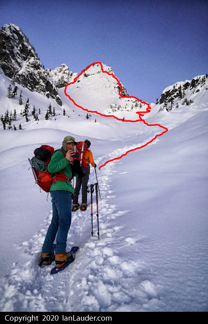
Fun winter climb of Chair Peak after a long spell of being weathered out and bad avi conditions. Had a good Thursday window. Looks like we were the first ones there in some time. No tracks or signs of any travel from the normal ski touring tracks in the basin below the base of the climb. So it was a slow slog up deep snow to the ridge right side of the base of the climb.
So the GoPro decided to snap a timelapse of stills on Pitch 1, but it still kind of works for the video. Wasn't my intention originally.
Got a 5:20am start at the trailhead, were roped up and climbing by 8:30am.
With the deep snow the gulley pitch was covered in snow but we could see a path to the first belay tree. Leading up got steeper than it looked from below, was able to get in a good nut before traversing over towards the gully. Was having to excavate a path across the slope as it was too loose to kick steps, had to dig out a full body path.

During that uncovered a bit of rock right above the more exposed drop before the gully. Dug down till I hit the rock and was trying to put in a nut that was pretty marginal, then tried to put in a piton but didn't have the right size. Lastly figured I could slot in a horizontal picket against the rock and that's when I uncovered the buried webbing slings. Clipped into those and continued excavating a path over and up to the gully.
Once there had some good sticks and got in a screw that felt okay. And it was an easy up to the belay tree with one more screw in along the way. The 2nd team behind me tried to put in a picket that just levered out and got a cam in the rocks.
From the tree belay Pitch 2 was a long slow slog through snow up to waist deep. The normal end of pitch 2 at the rock with the slings was buried so my partner ran out the full 70m rope and went to the top of the ridge and put in a horizontal picket anchor.
From there for Pitch 3 I traversed high along the wall and found a nice rusty piton halfway. The ice on the step was kind of rotten so only put in a couple marginal screws and continued up but stopped short of running out the 70m rope and stopped at 60m. Put in a horizontal deadman picket for the anchor.
Stopping short worked out as the 2nd team had a 60m rope and was able to get to the picket anchor and use it as we took off.
Pitch 4 was then just a straight up kicking a boot path in nice firm snow to the top.
There was enough snow up top we just went straight up the face to the summit and then downclimbed that part. From there we went down to the stand of trees but the rappel anchor was buried and couldn't find which tree it was on so we added a new one. Another party who followed up after us pitched in the rap ring.
This is the 2nd year in a row we got a rope stuck rapping this way though. The ropes run over a small notch in the rocks. Easy to get unstuck though. There was enough soft snow that first rappel could be downclimbed probably.
The 2nd rap station with the 3 piton anchor was well above the snow and we dropped down over the small cornice and finished off with a short face in downclimb after that.
It was about a 13hr day car to car with 2 teams of 2.Gear Notes:
3 pickets, 4 screws, 2 nuts, took a couple cams/light set of nuts didn't use them. Mostly placed horizontal picket anchors.
Approach Notes:
2+hrs to base, highway to Snow Lake, breaking trail from the basin to the base in deep snow. Using snowshoes.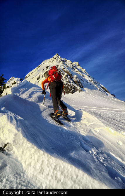
-
1
-
-
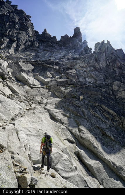
Trip: Mount Stuart - West Ridge
Trip Date: 08/17/2019
Trip Report:A successful climb of the West Ridge of Mount Stuart must start with a shout out to everyone we got beta from ahead of time from the route descriptions, hand drawn topo and photos that helped us navigate the maze of possibilities.
We packed fairly light (which still isn’t all that light doing a lot of exposed scrambling and a technical climb as a carryover) starting with packs between 25 and 30 pounds knowing we would be loading up an extra 4L of water each at Ingalls Lake.
Car camped at the trailhead on Thursday night and were on the trail just after 6am Fri morning.
We first tried to go around the right side of Ingalls Lake but appeared to be cliffed out right near the end. The choices were a chest deep wade around the corner or a slabby move that was a little to uncomfortable looking to start the morning out with. So, we back tracked and walked around the left side of the lake.
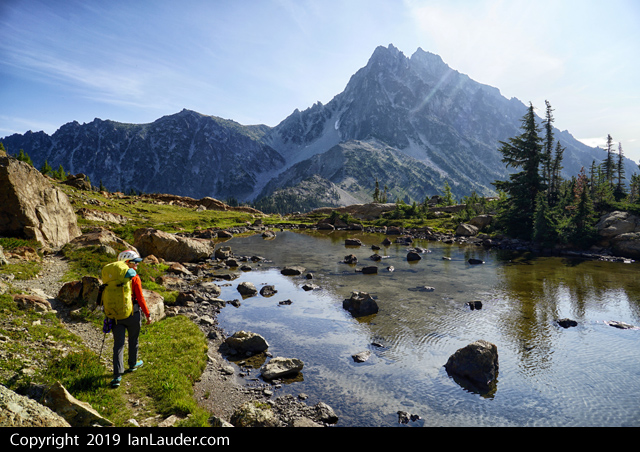
A quick trip to Ingalls Lake and we filled up all our water bladders and topped off all the bottles.
The weather was great, sunny with a nice chill and breeze. Gusting up to 20ish had us wondering about the wind on the route that was predicted to be in the 20s the next day with clouds and a slight chance of precip. We decided it was worth taking the chance and moved on to the base of the climb.
Navigating up the gullys was straight forward. Then we got to a choice of going up a low 5th chimney/gully or around to the left. 3 of us soloed up the chimney which only had one burly overhangy move. We dropped down a line for one person to belay them up that move.
From here looking over at Long John Tower looked pretty intimidating. We pulled out the photos with the hand drawn route options for the 5th class option or the 4th class option and neither looked appealing. We heard enough about the 5th class option being very awkward that we decided to scramble up the 4th class.
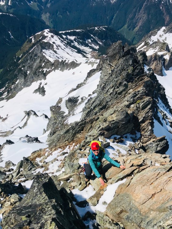
We picked out our route from a distance and headed that way. Fairly quickly after the 3rd class approach it gets your attention. We all headed up a long straight narrow gulley feature on the right, but we didn’t know if it would connect back over left at the top. Two of us about halfway up found what we figured was the “exposed airy traverse” and yea, its exposed and airy but the finger crack and foot holds were solid. From there we could see that the gulley the others were still in had a walk across to where we were. Kashan continued to the top and set an anchor and dropped a line to belay up Rodica the last half since it was getting very steep and exposed with some burly moves and high steps.
A short 3rd class scramble from there and we were over the hump and past Long John Tower looking across at the rest of the terrain we had to cross to get to the West Ridge Notch. It was about 3:30pm and we were about 9 hours into the trip. We figured we had plenty of time to continue on and find the bivvy sites closer to the West Ridge Notch.
We easily found the Dog move and got around the overhanging ledge and into the next gully. Eventually we were spending some time consulting the GPS tracks, printed beta and a hand drawn topo map trying to figure out which ledge, which sandy patch, which gully, which hash tag on the map was which. We had tracks that seemed to go up to a higher route and tracks dropping hundreds of feet and going around a buttress lower.
After a bit we then spotted a line of cairns that went straight across splitting the difference and decided to take that path. That route seemed to be not as travelled since we were on some fairly lichen covered rocks at times making our way from cairn to cairn and it was some very exposed 4th class scrambling in some sections but fairly easy with big holds and wide enough ledges. We wound up skipping the entire upper route and the features such as the Tunnel underfoot, the rock you climb through, the upper bivvy sites (which we wanted to hit) but it also meant we didn’t have to descent hundreds of feet down a crappy loose gulley then ascend the next crappy loose gulley. Once across we had a straight shot up to the West Ridge Notch. The whole section from LJT to the West Ridge Notch took about 3 hours.
Now it was 6:30pm and we needed to find the bivvy spots. Since were at the base of the climb little did we know if we scrambled up a little bit from the notch we would have found a site we probably could have squeezed all 4 of us on, but it would have been very windy and maybe a little too cozy.
We dropped back down the gully maybe 200ft and around the tower with the balanced rock, up just a little bit to the notch and found a line of bivvy sites right around 9000ft and hunkered down for the night with an awesome sunset.
Up the next morning at 6am to blue sky and not a lick of wind we lucked out on the weather forecast and we were back on our way to the Notch at 7am.
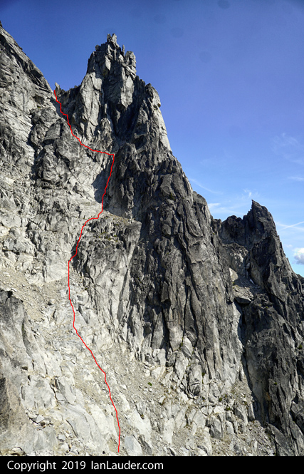
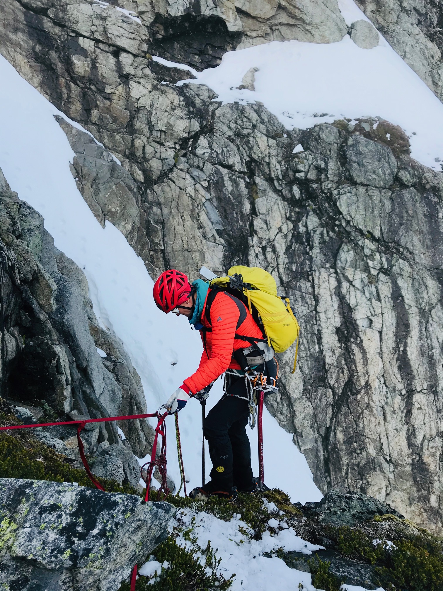
We started the climbing around 8am after scrambling up to the base of the first pitch and finding the spot where we needed to traverse out then back up around the spire at the base. Since there is a bit of a downclimb from there we setup belays at the top to reduce rope drag then scrambled down to the base of the 2nd pitch.
From the base of the 2nd pitch Rodica led off and went straight up the right-hand side which had a burly overhangy move at the top while Andy went up the left-hand side and everyone grouped up on the ledge. From there we had to look around for where to go next. It looked like there was some worn down surface on the right-hand side where it was a slabby move with a wide crack up against a wall. There is a nice pinch point for a sling and a bomber anchor to make the committing move up. And that turned out to be the spot that put us right at the next downclimb to another bivvy spot and belay for the next pitch.
From the base of the 3rd pitch we had a nice photo from beta we got from some friends that showed we needed to do a zig zag move going straight up, over a large block then right then up another section to the next belay ledge. This was some bad rope drag, so splitting this pitch into 2 would have been preferable which is what Andy and Khrum did.
From the base of the 4th pitch we had all grouped up and after consulting the beta decided the route was to go up little bit then traverse around the base of a large square spire (which I think is also the move referred to as the “belly flop”) which wasn’t hard, just a bit awkward. From there it was easy scrambling up and to the right around a corner to the crux section which has a fixed piton at the burly overhangy move, preceded by another burly pullup/mantle move onto a nice flat alcove where you can reach up and clip the piton. Its easy once past that move to a nice belay ledge. We stopped here as it was a good spot to haul up someone’s pack if they wanted to make the burly move at the piton easier.
From there the next pitch was just an easy scramble to the summit block where we ran into groups all coming up from every direction. All in all it took about 5 hours for the four of us to do the climb from the West Ridge Notch to the summit where we topped out around 1pm-ish.
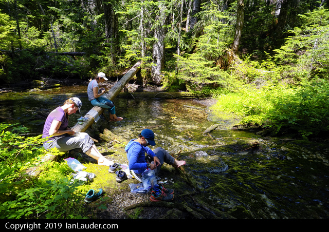
Then it came time for the long 6000ft descent (~4500ft down to the creek, another ~1300ft up to Longs Pass, then ~1500ft down to the trailhead). We took some time to soak our feet and refill some water in the creek. The 4L each we filled up at Ingalls Lake got us all the way down to the creek the next day without running short. 3L probably would have worked but we would have had to melt some snow field after the summit. And if it had been a really hot and sweaty 2-days 4L might not have been enough. We found 1 tiny remnant of snow on the route that was literally 2ft by 6inches and was probably already melted by the next day.
On the descent on the way to the Cascadian Couloir I could have sworn I was smelling a cigar or a pipe and figured maybe I was just kicking up some odd smells from the dirt. But sure enough, I look up and some guy in spectacles and a mustache wearing what looked like full length red pajamas that could have been out of a Dr. Seuss book walks by smoking a pipe on his way up the scramble route. Random.
This is a climb you really need to have some experience and comfort with exposed scrambling and be prepared with route beta and take your time to get your route right. It would be pretty easy to get off route just winging it and getting into terrain you might not be ready for. And we already know someone who spent 2-days off route on the West Ridge getting into 5.9 territory they weren’t prepared for.
Got back to the cars about 12hrs after having left the bivvy site. Turned out that was a great split for the 2-day carryover trip. About 12hrs each day using the 9000ft bivvy sites.
Gear Notes:
Light alpine rack (.3 to #2, nuts), 40m rope, 4L water each
Approach Notes:
Nothing new I could add to the normal approach beta other than there are no water sources after Ingalls Lake till the descent from the summit. -
10 minutes ago, JasonG said:
 Classic rival faction gossip
Nah, just expressing some concern that they would get back okay without knowing enough about them.
-
10 hours ago, Mihai Iancu said:
My daughter and I were the pair that you met on Sunday on your way down. All day in approach shoes, no ice axe or crampons, I had a 30 meter rando rope which we did not have to use.
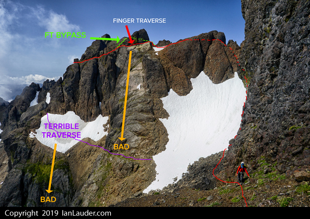
We left Olympia at 4:20 am, a little before 6 am we started up the road, we had bikes. At 7:15 started up the trail, at 9 am at the lake. We went up the North Chute, continuing with the Finger Traverse, on the summit at 1 pm, we spent an hour there.
On the way down we took the Terrible Traverse. We could easily avoid the snow just below it and then climbing up the little buttress on the left. We had to go on snow to the notch in the east-west ridge but by that time in the afternoon, with eastern exposure, it had softened enough for comfortable step kicking. Then down on the South Chute.
Back at the lake at 4:30 pm, down to the road at 6:05 pm, at the car at 7 pm and back home at 8:35 pm.
We didn't see anybody else the whole day which was a very good thing. I believe now that the road closure and the access "trail" are critical for that mountain, to keep people away. For much of the route, being there with teams above you, would be suicidal!

Damn, you two are fast then, we knew we were only going camp to camp that day so didn't rush. One of the guys with us remembered your daughter from the basic climbing course and didn't think you two would be fast enough to get back down before dark from what he remembered, that and another guy we passed hours ahead (the day before) going solo had turned back. Too bad we didn't talk longer and get names, my wife you passed by is Romanian - she's just been looking up some of you past climbing. Yea, you kicked our butts
") Interesting you didn't pass anyone else because 2 other guys headed up that way from the lake around 7:30 (maybe 1.5hrs ahead of you) we figured they were on their way up as well, perhaps they took a different route. Definitely a place I wouldn't want anyone above or below us in many places.
Interesting you didn't pass anyone else because 2 other guys headed up that way from the lake around 7:30 (maybe 1.5hrs ahead of you) we figured they were on their way up as well, perhaps they took a different route. Definitely a place I wouldn't want anyone above or below us in many places.
-
Trip: Mount Constance - South Chute & Finger Traverse & FT Bypass
Trip Date: 08/03/2019
Trip Report:SummitPost wasn't kidding saying Mt Constance is one of the most challenging peaks to climb in the Olympics. Its the peak seen from Seattle that has the biggest prominence on the horizon.
We did a "Leisurely" 3-day trip (24 miles & 9400ft gain) to climb Mount Constance in the Olympics. We figured it would be a 20+ hours of hiking and climbing and pushing bikes up the approach would only make the hot day hike in harder only to shave maybe an hour off the whole thing. In the end we were just fine having not brought bikes. Its a quick enough and easy hike out they really aren't needed. That said the rangers did warn us if we were taking bikes to hide them as people even 5 miles in will strip bikes of parts and just leave the locked frame behind.
After picking up our permit we did the 8 mile hike and 3rd class tree root scramble on Friday to get to Lake Constance in 5 1/2 hrs. Maybe a bit slower than usual but it was hot and humid so we took our time since we really weren't in a hurry. Great campsite right at the lakes edge and not a bug to be seen.
6am start on Saturday, returned to camp 6pm. 6.5 hours up and 5.5 hours return. Great to not feel rushed trying to pack it into 2-day or even car to car. This would be a 20+ hour day trying to do it in a day and with it mostly melted out its a huge amount of boulder, scree and loose rock scrambling which would probably added some hours vs if it had been more snow covered.
Did the Finger Traverse Bypass route on the way up which was some interesting navigation around a hidden ledge and chimney system around the backside of that block of rock. If you find two tiny rock bivy site rings near the start of the Finger Traverse you are pretty close to finding the drop down to a ledge that looks like it cliffs out, but if you work your way down a narrow 10ft chimney you almost have to wedge yourself into it drops onto another ledge that works its way around and spits you out on the other side of the Finger Traverse.
No running water on the route once we left the camp but were able to refill water bottles from snow patches along the way and wound up with plenty of water.
On the way back we soloed the first half of the Finger Traverse then broke out the rope to lead around the corner considering its a literal finger traverse with not much in the way of foot holds if you are short with a monster runout over a cliff. You can setup a belay about halfway across in a nice alcove with a boulder to sling. Then sling a horn on the way over, place a #1 cam, then around the tricky corner there is an easy to miss rusty piton as you angle back up to where you can setup a multi-point gear anchor.
A solo climber we passed planning on doing the route in a day on our way out was planning on soling across the Finger Traverse but wound up turning back once he saw how exposed it was. We also saw a pair on our way out around 8:30am still an hour from the lake who were carrying light day packs planning on doing the route in a day but they were hours behind where they should have been to get out of the technical terrain before dark.
If you like scree surfing coming down was a fun run down 3 long scree fields.
I wouldn't want to do this route in wet conditions. We had great weather and everything was dry.
I think this one set the bar for the most amount of scree, loose rock and boulder hopping we've ever done in a day. And a lot of twists and turns navigating a complex route. While it wasn't high on the technical scale its a beast stringing the whole thing together. Over 20hrs moving time between the climb and hikes in and out.

Gear Notes:
ice axe, crampons, light alpine rack (#1 and a couple smaller cams & a few nuts), 40m rope (the one that used to be 60m before a snaffulhound on Mt Cruiser chewed through it...)
Approach Notes:
boulders, scree, more scree, boulders, scree, little bit of snow patch, more scree.... don't under estimate the amount of scree, loose rock scrambling and boulder hopping once its melted out.-
1
-
2
-
-
No worries, nobody is drifting around the corners. Just don't need to drive the FJ at a crawl behind a minivan on the straightaways. I'm always going slow around corners with one foot on the brake. And that brings me to another pet peeve, while I do appreciate when someone pulls over its nice when they use the pullouts. I had multiple people this trip decide to "pull over" by just stopping in the road at a blind corner to wave me by. At least they weren't as bad as the time I had someone driving in the oncoming side around a blind corner because they were too scared of the edge. And there wasn't an edge.
-
A couple months later. Don't forget to always check that webbing all the way around. Just saw a report that someone almost rapped off one of those anchors on Cruiser before someone else checked it and both "new looking" pieces of webbing were almost chewed all the way through on the back side.
-
We must have just missed all that. We didn't notice anything going on at the trailhead and no emergency vehicles.
But we did hear a helicopter when we were at camp the night before, figured that wasn't a good sign. We were leaving the trailhead about 5:30pm on Sunday. -
That was my normal driving speed. Agonizingly slow and who wouldn't pull over. Most people get the hint after a couple minutes, not a couple miles. Everyone else is nice enough to pull over pretty quick, but sometimes you get that guy who says - F'u, you're behind me. Just a clarification, we didn't hurry up and wait at the trailhead. We left home later knowing what the weather forecast was going to be and timed it to start before 3 and get to camp in time to hopefully also climb something that day. Worked out as expected, people coming down Sahale Arm had turned back just a bit earlier in the rain.
-
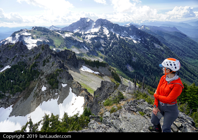
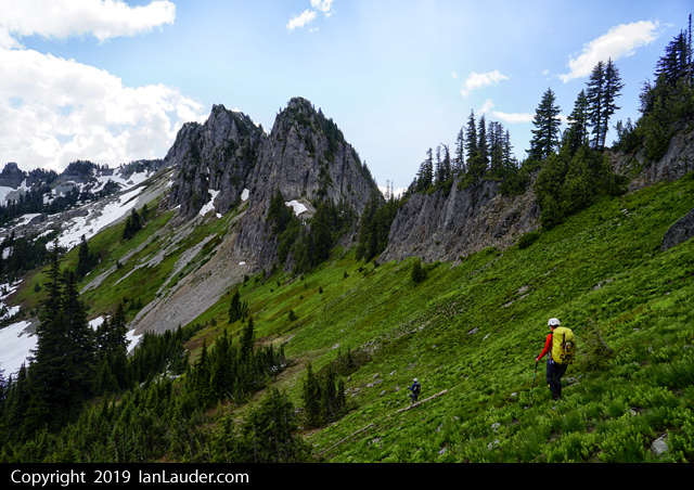
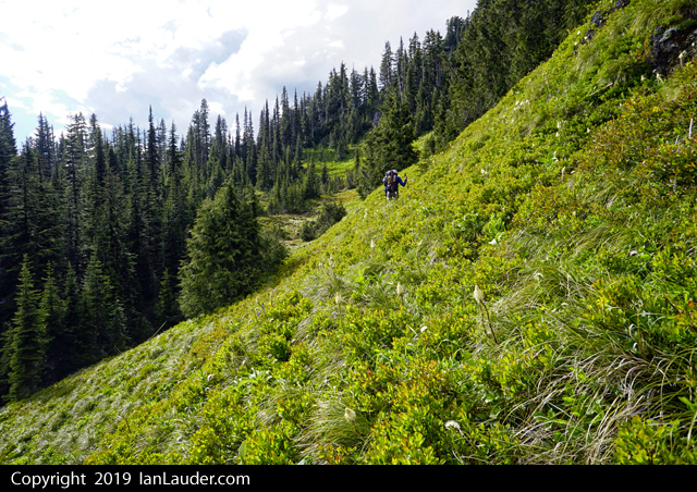
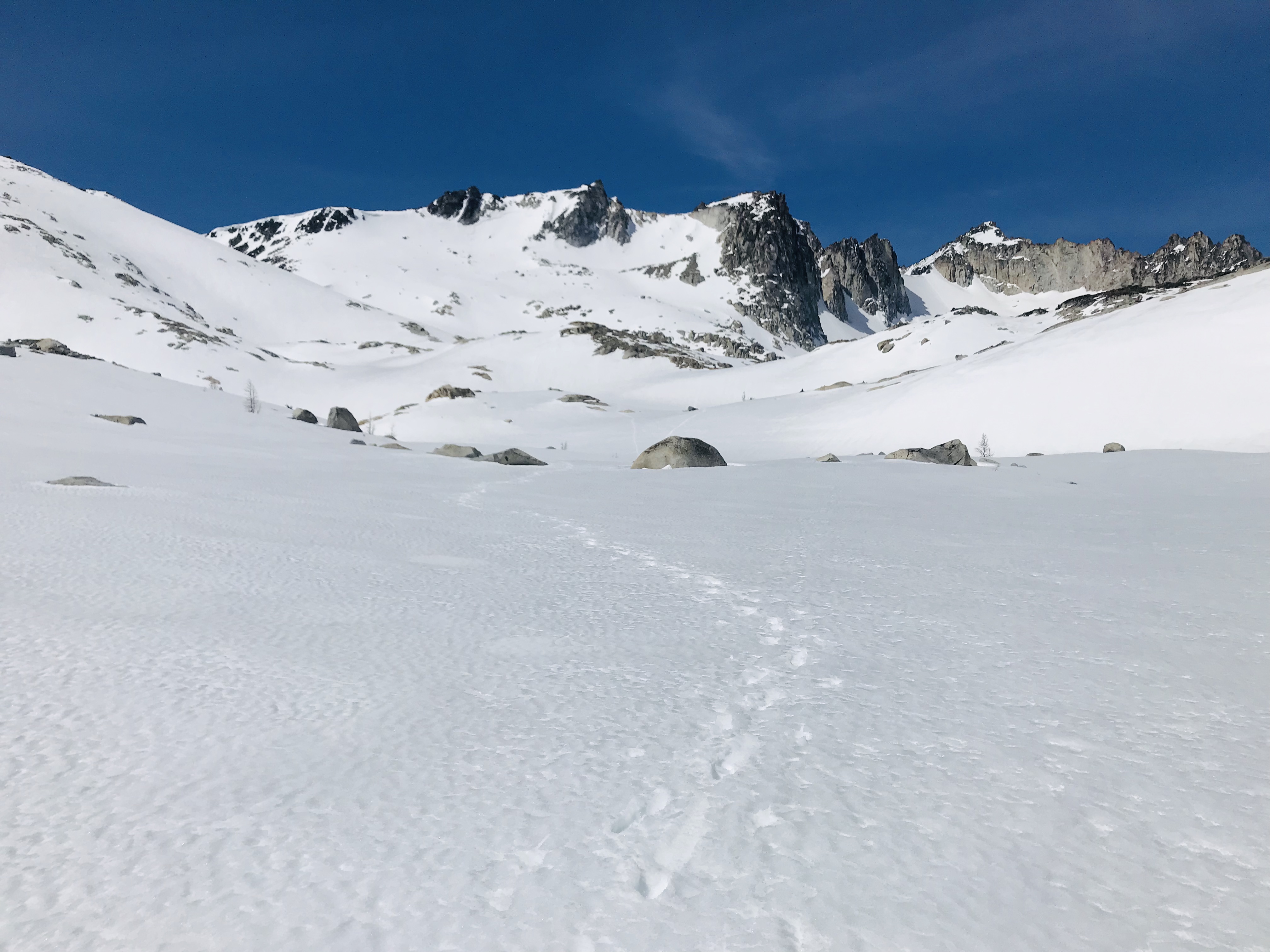
Trip: Magic Mountain (and Arts Knoll) - South Ridge
Trip Date: 07/28/2019
Trip Report: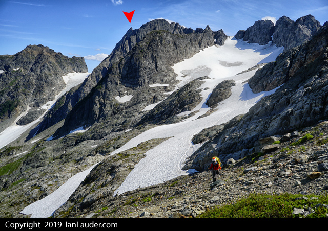
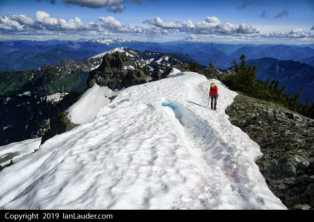
After a couple long haul weekends decided to take a rest weekend and do something easy on the other end of the Ptarmigan Traverse after having been out to Dome and Sinister last weekend. Decided on a scramble of Magic Mountain.
Gotta love the masses driving into Cascade Pass. At least most people would pull over pretty soon for us to pass on the way end except for a couple. First one was the red truck with some redneck hanging his cigarette out the window who after quite a few pullouts passed was doing it on purpose. Finally gave up and floored it around him on a straight stretch with a foot to spare on either side. Next few people pulled over right away which was nice, always give them a wave on the way by. Then came the minivan from Texas. First time in a decade driving mountain roads I've started using the flashers, waving my hand to point to them to pull over, driving on their bumper over and over and backing off to give them room to slow down and pull over. Took forever before they finally got the hint. I almost had to start honking. I'm still to Seattle polite too honk.
We had to start a few hours later than planned for the weather to clear so didn't get started till about 2:30. Cascade Pass was still socked in as we started but the clouds were being pushed out as we hiked in all the way. Took about 3:45 to get from trailhead to Kook-aid lake.
Topping out on the Cache Col met up with a pair from Portland who happened to be planning Magic Mountain the next day as well. So we told them when we would be there and would look for them. On the way down I noticed crampons on the ground next to them but figured they were theirs and they were still reorganizing their stuff from the glacier and didn't think anything of it. They had planned on camping there at the col. We continued on to Kool-Aid lake.
Weather had cleared quite a bit with nice views of Formidable. Magic was still in the clouds but Arts Knoll was in full view. Since it was only 7pm by the time we got camp setup decided to go hike up Arts Knoll. Easy traverse over and up the red ledges. By the time we got to the top in an hour the clouds had rolled back in and we wound up getting back to camp in a whiteout and in the dark by headlamps. Took about 2:30 round trip being a little tricky to get through the boulders with only 30ft of visibility.
A few other tents had shown up at the lake by then.
Next morning as we were getting ready a lady walks up with a crampon asking if we had dropped it at the col. Nope, not ours. Told her there was a pair of climbers up at the col and it could have been theirs. But we also checked with the other tent. On the off chance it was that Portland pair we met the day before I took the crampon from her and said I'd pack it out. Then left it at our tent as we headed up to Magic.
Fun little scramble. Up to the col, left the climbers trail halfway up to initial hike up from the col and got on the ridge as soon as possible and scrambled that all the way to the drop before the summit spire.
From there it was extremely loose rock but still not too difficult to pick our way through it. Down around to the right and up and over a giant quartz band. Then went straight across to the final gully up.
The runnout is over a cliff but it doesn't look too bad. Lots of loose rock but easy scrambling up to the summit block. Probably not a good first time scramble.
Once on the summit block spotted the Portland pair where we stashed some gear before dropping down into the loose stuff. Heard lots of rocks cutting loose as they were coming down so we discussed waiting till they got up to the summit block before we would head down, then decided to head down right away so we would pass them on the horizontal traverse down below out of each others way.
By the time we got down hadn't heard or seen them. They had turned back partway down the loose drop. Once we were coming down to the col finally spotted them passing our tent (and just feet away from that crampon sitting on a rock outside the tent).
Our original plan had been to climb Magic, Hurry-up and Arts Knoll but with the late start and Rodica not feeling that great (figuring it was probably that powdered milk we just starting trying out). Decided to skip Hurry-up and we would have just enough time to get to Cascadia Farms. Barring any slow drivers who wouldn't pull over.
Hung out for an hour for lunch and to break down camp. Had a group of 6 who had gotten turned back from Formidable in the storm the day before pass by.
On the way out at the base of Cache Glacier I thought I saw a big marmot sitting on the boot track where we put on crampons on the way in. Once it started moving it wasn't a marmot. It was a wolverine about 300 ft in front of us. It took off down the snow into the rocks. Once we got there and took some pics of the paw prints they were about as big as my hand.
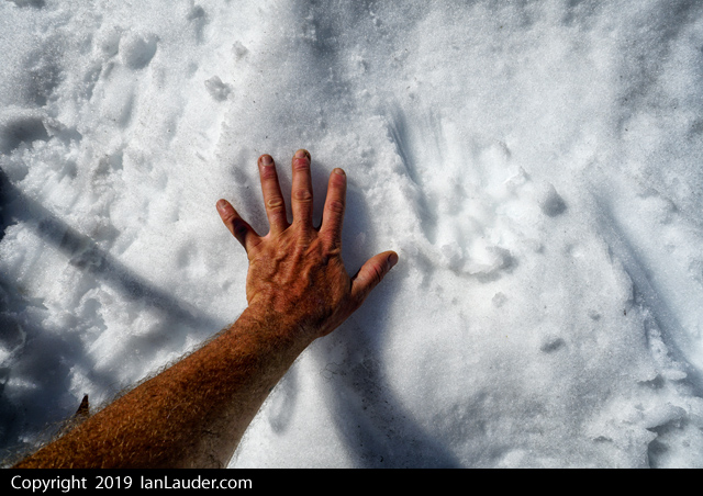
Our 2nd wolverine spotting this season in the area. That was pretty cool.
Cruised down to the trailhead and were out with just enough time to get to Cascadia Farms.
Standing in line there was a couple right behind us, we said we weren't in line, just waiting. Then they asked if we happened to have been up on Magic Mountain. Then we all recognized each other without the climbing gear. They asked if we happened across a crampon and they had heard someone had taken it from the col.
Well, yes. We didn't take the crampon from the col. But I do have it, its in the truck.
We also have a pole we picked up on the ridge to Magic. If anyone is missing one. With the markings its someone's who's name starts with "R".
Gear Notes:
Crampons, ice axe
Approach Notes:
Easy hike up and easy glacier crossing.-
1
-
-
HAHA, yea. We had a rope, it was just down at the base of the climb with a couple other people, so we just had wait awhile for them to get it and toss it over. Towards the end we figured out a possible way down without it involving going back up the gully about 15 feet, scrambling up and out of the gully then working over about 15 feet to a sloping ramp that spits you out on the rocks you can step onto the snow from. The person that brought the rope up managed to get up that way and over the gully. If we had really gotten stuck we probably would have figured that out at some point. Worst case we could have retraced the route but that would have taken a lot longer and the person I had with me I didn't want to put them through that.
-
Trip: Sinister Peak / Dome Peak - West Ridge
Trip Date: 07/21/2019
Trip Report:3ish day trip to climb Sinister and Dome.
Hiked in the first 6 miles on Fri night to 6 Mile Shelter.
Saturday hiked the 8 miles in just over 7 hours to Iswoot Ridge (thick wet bushwacking for a mile, hornets and a bit of off-route travel here and there).

21 hour day on Sunday. The route to Sinister is just about out and we weren't even sure it the glacier would be passable. So we considered it a bonus if we could get there. Had to do a much longer downclimb and side traverse around the bergschrund and over another lower crevasse just to get started from the Dome saddle. There were faint previous tracks that went down a shorter downclimb and over a snow bridge that has now collapsed (you can see that 2 pictures down).


Only had to backtrack from one path that was a dead end, then the final crevasse leading to Sinister had one small snowbridge left we could cross. Other than that the navigation was pretty straight forward even if it did involve some weaving around a number of large crevasses.
Burned most of our time getting there and only had an hour before our turn around time to climb. We figured if we could do a quick run up we could make it in time to get back for Dome.

After re-reading the route beta we had printed out that it was some 3rd class with a + move and then to easy 2nd class and no mention of gear or ropes we went up without rope and gear, which in hindsight wasn't a good idea. Turned out the people who had written that trip report had pitched it out and rappelled and one thought it was 4th class. Found that out after we got back. With approach shoes I thought the climbing wasn't bad, just 4th class exposure in a couple places. But everyone else had heavy boots which made those moves more thought provoking.
The first 3rd+ moves after getting up the gully turned back half our group and the other 2 of us up higher had to descend a 2nd parallel gully that had a 4th class move to get down into. Plus I had to poach rappel slings off a couple rap anchors to use as makeshift handlines to lower down a couple moves on longer slab to get people down a move on each of the gullies. So if anyone sees a couple free hanging pieces of webbing, that was us...
The gully that is snow filled that could be scrambled down early season was melted out to the point it cliffed out about 15 feet above a moat. So, we burned another couple hours getting a rope up to rappel down. The other half of our party walked back around to where we dropped the gear and was able to lead up about 20 feet next to the gully and tossed the rope over to us and we rapped back down. After doing some exploring where the right gully cliffed out and scrambling up climbers left and out of it and moving left about 10 feet its possible to get out of it without a rope, but would involve about 10 feet of kitty litter angled slab with questionable holds. We didn't have to resort to trying that as by then we had the rope to rap down with.
In hindsight double checking what we did we were on route but it was confusing and didn’t match up with the beta we had. Plus 2 different gps devices showed us in different places which added to the confusion. Finding 4 rappel stations and 4th class climbing when we were expecting 3rd class made us wonder if we were on a different route. We could have done a better job digging around for more beta on this one.
Busted back to Dome as fast as we could and barely had time to summit that just at sunset which was an awesome view. Spent the next 3 hours navigating back to camp in pitch dark. Halfway there 2 rechargable headlamps without spare batteries had died and we were navigating back with cell phones.

Late dinner at 1am. Slept in late on Monday and had a more relaxed day with a long hike out with dinner at Taco Bell in Arlington at midnight.
Good times. This one throws a lot at you. Might be one of our favorite trips so far - except for that getting cliffed out part.
We'll be back but for the North Face next time. We got the best and hardest parts of that route, good enough for the first try on this peak.
The concerning part turned out at the end of the trip. Back at the cars the next day ran into a guy who had the next morning summitted Dome right after us who had met a 20 something year old with little glacier experience and wearing tennis shoes with crampons and an ice axe doing the Ptarmigan Traverse who he saw following our boot tracks solo over to Sinister. And he had made it past the first bergschrund. No idea what the rest of his skills are or what he knew about Sinister. Gonna have to keep our eyes open for any reports on if he made it back and how far he got. If anyone hears about a kid soloing Sinister this weekend drop us a note how he faired.
Gear Notes:
40m rope, light rack, ice axe, crampons, stuff
Approach Notes:
Heavy wet brush on the way in, dry and fairly beaten down on the way out.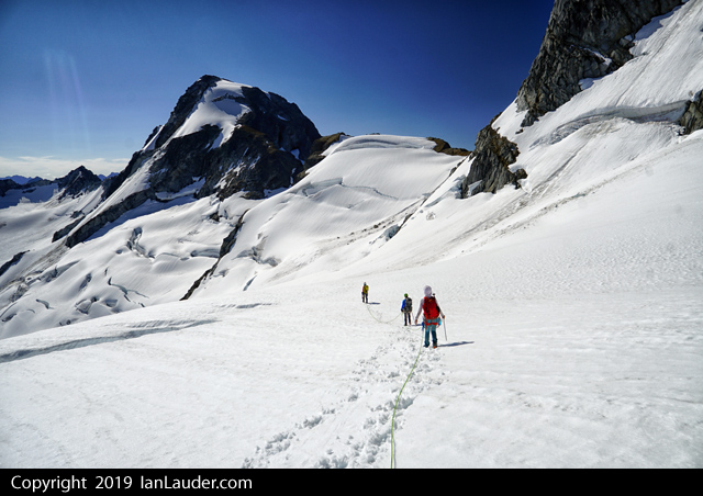


-
1
-
3
-
-
Trip: Tatoosh Range - Tatoosh Traverse
Trip Date: 06/30/2019
Trip Report:12 peaks with 2 rock climbs in 2 days. 25 hours moving time. About 18 miles and about 9000ft gain.
So, this isn’t one of those “fastest time” kind of trips, no trail running involved. Just 3 climbers with 25-30lb overnight packs and climbing gear.
With our 9-day Pickets Traverse plan weathered out we kicked around ideas for the weekend and decided to roll the dice on the slight thunderstorm forecasts around Rainier to do the full Tatoosh Traverse.
Picked up a camping permit at 7:30am on Sat at Longmire and were on the trail by 8:50 at the Snow Lake trailhead having left a vehicle back at Longmire.
4 hours in we tagged Stevens Peak after having done a long off trail traverse below Unicorn, some thick bushwhacking down into a snow filled basin that took us up to the saddle between Stevens and Boundary. Saw a fox right at the col as we popped up.
From there ran the ridge back to the saddle and on to Boundary peak, from Boundary we were at Unicorn by 5pm and climbed the 2nd 5.6 route. From there went up and over Foss. Thought we spotted a boot track in some snow on the way to Castle and went to follow it, but it was a fresh bear track. Got to the base of Castle by 8pm and setup camp. 4 down on day 1. So, we would have to hustle to get 8 on day 2.
Found running water at this point only in the basin on the way to Stevens, running off a wall on the backside coming off Unicorn and a convenient little stream right at the top of Castle near our camp. Rest of our water fills had come from stuffing water bottles with snow along the way.
Up at 6am and on our way to climb Castle before 7. Finished off Castle, packed up camp and had knocked off Pinnacle within 2 hours. 6 down 6 to go.
From Pinnacle headed over to Plumber then Denman and had those knocked off within an hour each. 8 down and 4 to go.
Up next was Lane Peak which was a little trickier. We wound up scrambling up the narrow gulley that we remembered having ice climbed up last winter right to a tree that had a rappel sling on it. The gulley seemed to be 4th class or 5.0, easy climbing but really exposed but good rock (as opposed to the rest of Lane). Then we found a scramble path down climbers left of that gulley for the way down. #9 down and 3 to go.
Had lunch and it was about 1pm at this point. Took longer to get over to Wahpenayo having to do a long traverse side hilling over heather and screen slopes then turning upwards about halfway to gain the ridge. On the other side it was a mix of snowfields and ridge running to get to the summit. #10 down and 2 to go.
Some more steep heather and grass slope travel to get to the climbers trail between Eagle and Chutla and some more bushwhacking through trees. Right about when the predicted thunder would be starting, we were hearing some thunder nearby and started getting a little rain. But still had sun and blue sky to our South and we knew the thunderstorms were predicted more over Rainier to the North.
At the trail we dropped packs and cruised up Chutla Peak crossing our fingers the thundercloud wouldn’t get worse. #11 down and 1 left.
Cruised back down to our packs and did the short traverse over to the saddle and dropped packs again. Had a quick discussion about how we felt about the thunder and decided to get in the trees and start heading up Eagle as we still has some blue sky and sun to one side. #12 of 12 down and by the time we were back at our packs the storm clouds had moved off and we were back to blue sky.
Long trail back to Longmire and back late evening before dark.
After picking up the car shuttle and back to Ashford found the only place open to eat anything was the Highlander where we got a big pizza that was a combination of a little overcooked and undercooked but was everything we needed.
Too tired to drive home we crashed in the cars in the parking lot across from Whittakers Bunkhouse. I must have been low on salt from sweating buckets for 2 days all I wanted for breakfast the next morning was a salty French dip and a bag of chips which I found at the bakery in Eatonville.
According to the beta we read after the fact a full Tatoosh Range traverse of all 12 peaks with overnight gear takes about 2.5 days and involves hiking in the night before the start and finishing at twilight the "3rd" day if you count hiking in early on Friday for a Sat/Sun traverse. So, we did it 2 days flat without an early hike in. We started at 8am after getting permits on Sat. Did the longer and harder initial approach to Stevens. And finished at 8pm the next day before dark. And we didn't cut corners on the technical climbing where some people only do the easy pitches or the scramble routes. So, way to go team Rodica and Philip. Beast Mode.
We just grabbed some gpx tracks we found somewhere and what we collectively remembered from having done most of the peaks individually or in small groups at one time or another in the past and winged it.
Gear Notes:
40m rope, light alpine rack, ice axe, crampons
Approach Notes:
Snow Lake trailhead, lower traverse under Unicorn to basin up to saddle between Stevens and Boundary. Then after Stevens and Boundary did the standard traverse hitting all 12 peaks. Plenty of snow and water sources available for water. No bugs out. Great conditions.-
1
-
3
-
-
4 hours ago, Thasiet said:
Would be me and my associate. We followed the same line you took up the cliff, summited at 1:00. We didn't learn about the snow bridge collapses ourselves until we were almost upon them on the way down

That's great to hear, we were hoping you guys made it without any issues or that we hadn't kicked any ice down on you. That's a great shot you got of Rodica.
-
43 minutes ago, JasonG said:
DUDE, CAN'T YOU LISTEN? The entire Coleman glacier is OUT!
Interesting that it is that close to being problematic this early in the year....
Yea that was pretty much his reaction. We went back and forth a couple times as he didn't think I understood the gravity of the situation.
-
Trip: Mount Baker - North Ridge
Trip Date: 06/15/2019
Trip Report:Climbed the North Ridge of Mount Baker on Saturday morning, awesome day.
Hiking in we met a climber we knew who said the snow bridge across the Coleman/Deming had collapsed the night before and parties were turning around. But they saw someone who had rapped into the crevasse and walked out, so we figured one way or another we had a way down.
Ran into some skiers on their way down who warned us very emphatically that the bridge was out. We were like, okay thanks. Then he repeated "its out, the bridge is OUT". Okay thanks, we got it.
Got to the snowfield and found a large group of about 6 who were bailing out because they heard the Coleman was out. Okay, on we went.
Got camp setup around the 6600ft football area and had the place to ourselves early afternoon.
Not much in the way of tracks we could see so we hiked about another 1000ft up to the base of the ridge to log a track and make a bootpath to follow the next morning. We did start to pickup some previous bootprints around the base of the ridge.
Started up around 3:30am on Saturday and got to the base of the climb around 7:30. Saw previous tracks that came up both the left and right sides of the ridge. Most went lower around the base so we took that path which worked out great.
As I was leading up the ice pitch saw a pair coming up behind us. First people we saw that day. A guide and his client we leapfrogged the rest of the route with. As I was belaying up my wife another pair of climbers were getting to the base of the climb, but we never saw them again. We also saw 3 climbers much further down the ridge but never saw them again either rest of the day.
Got to the summit around 10:30am. Steep in sections but there was a cruiser bootpath already there. We only had to kick back in part of the path traversing over toward the base of the climb that had melted out quite a bit.
On the way back down the Coleman, as expected, people had figured out the end run and the Coleman/Deming route was just fine.
Back at the trailhead ran into another group heading up for the North Ridge who had just left a car shuttle at the Easton trailhead to do a carryover because they heard the Coleman was out. Bummer they had to do that.
Gear Notes:
60m rope, 3 pickets, 6 screws.
Approach Notes:
While the snowbridge at the end run was in (where I was standing in the pic above) and is the way across it does look like it could collapse further. And rangers are saying its the worst conditions they have seen in 25 years. Just an FYI to check your route options before you go.-
1
-
1
-
-
15 minutes ago, JasonG said:
 !!!!!
!!!!!
I've had pretty good luck putting all stuff not in a tent in my pack liner (garbage bag) at night. The whole snaffle running around and biting hands during the day though.... Yowza.
Yea, from now on will do that. First time in 10 years had a rope chewed up. Were more concerned about salty stuff and goats. Didn't see any goats though.
-
Trip: Mount Cruiser - Southwest Corner
Trip Date: 05/26/2019
Trip Report:Note that the road was opened by the park service only for Memorial Day weekend and has otherwise been closed for construction. Check ahead of time with NPS about the road access to the trailhead.
Also, some beta such as on Summit Post says NWFS pass is needed. If you park at the trailhead you need an Olympic Park pass (can pay cash or credit card in the envelopes) if the booth is closed. Could also park on the road outside the park booth and walk in. NFWS pass may be needed at that point?
Weather was wonky everywhere this weekend. Olympics had a potential window for Sun/Mon so we changed our plans 4 times before deciding on a 2-day Cruiser trip.
Plan was to hike in Sun and camp at Gladys Divide (note a camping permit is needed for either Flapjack Lake or Gladys Divide, they are in the same zone). So we got permit by phone from the Hoodsport WIC on Friday.
(view from camp up the approach to Beta and the Needle)
5hrs from trailhead to Gladys Divide and pitched camp around 1pm. A couple guys came down from Beta right about then said the weather in all directions looked great. Originally there were slight chances of thunder starting around then. So since weather was shifting and Monday was looking potentially worse we geared up last minute and decided to make a run for the climb right then at 2pm figuring we would be coming back to camp around dark.
(3rd class scramble up Beta from the Needle)
Only took us 1:45 from camp to the base of the 4th class scramble up Cruiser.
(2nd rap anchor, there's a tree anchor as well a bit further left, a 60m rap will get you to the snow from the tree, we didn't use this one).
The 2 gullys were a mix of snow, rock and moats but were navigable.
(the "4th class move", just a step down)
There were a pair of minimalist climbers ahead of us. Picking out their footprints in the snow in a few places sped up our routefinding of the gullys. So, whoever you two were Thank You. First one with the "4th class move" was easy, finding the 2nd gully would take a bit of poking around if you didn't know where to look, we stayed high on the ridge where the snow topped out, then dropped down the ridge. From there it was a mix of rock scrambling, crossing the snow, and navigating moats to the base of the climb.
(navigate down the 1st gully, skirted the moats and then find the next long gully, which was a mix of snow, rock and moat navigation)From there another 2 hours for the first of us to climb the 4th class pitch, up the 3rd class through the cannon hole and then climb the standard route to the summit. That put us there around 6pm. Probably around 8:00 to 8:30 before we had all 4 people back down at the base of the climb and ready to head back.
(first view of Cuiser from the top of Beta before dropping down the 1st gully)Another 3 hours to get back to the camp at 11:30pm. With the sun going down we were going back up the 2nd gully in the dark then taking it much slower down the 3rd class scramble of Beta.
Did a double rope rap from the tree anchor on Beta which got us a bit down the snow slope. Snow conditions were easy enough to run down the entire slope to camp.
Around 19 hours actual moving time car-to-car for the climb with 4 people (with overnight packs).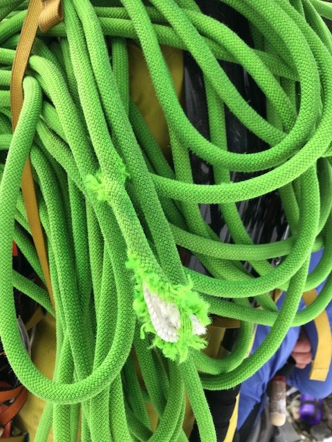
There is a mouse or snaffulhound at Gladys Divide sporting a new neon green nest. Woke up to a shredded rope the next morning.
One of the minimalist climbers we met also had a chunk taken out of his climbing glove from a snaffulhound that bit his hand at the top of the 4th class gully scramble rap station. I saw a couple of them running around the climbing route.Gear Notes:
ice axe, 60m rope, crampons (not really needed), light rack (.5, a couple microcams, #2 cam, a few slings, cordellete for belay anchor) - brought more pro but didn't use it.
Approach Notes:
5hrs trailhead to Gladys Divide, bit of snow starting below the divide, snow covered approach to base of Beta, Beta is snow free, mixed snow/rocks/moats in the gullys but navigable. 4th class scramble and route are snow free. 1:45min from Gladys Divide to base of 4th class pitch.-
 1
1
-
1
-
-
Trip: Colchuck - Colchuck Peak, DragonTail Peak, Enchantments
Trip Date: 05/04/2019
Trip Report:Decided to do a long 1-day solo trip of Colchuck Peak and Dragontail. Last minute decision to exit through the Enchantments.
22 miles, 8000ft gain, 21 hours.
Started at 10:30pm on Friday, timed it to get across the slopes to Dragontail before they got much sun. Temps through the night were in the 30s.
5 hours from Bridge Creek to the far end of Colchuck Lake, pretty good snow conditions, minimal postholing with boots.
Colchuck glacier was in great shape, easy walk up to the col. Colchuck is melted out more than I've seen before this early. Mix of snow and rock.
Gully from the col to Dragontail was in great shape, climbed the rocks to exit to the ridge. Started across towards Dragontail peak around 9:30am. Summit of Dragontail by 10:30am. 12 hours on the dot. Being that early figured I had all day to go through the Enchantments instead of Aasgard Pass.
Glissaded down the slope from the base of Dragontail into the Enchantments. Snow was firm and fine for hiking all the way across in boots. 14 hours in was almost to the exit down to Snow Lake.
Took 6 hours to finish the exit out to the Snow Lake trailhead. Posthole hell. Figured that would be a popular enough route there would be some kind of bootpath kicked in to follow out. Nope. Only saw 3 people camped at Colchuck Lake on my way in, didn't see anyone else till coming across a couple pair of skiers on their way up from Snow Lake.And a big thank you to the awesome couple from Canada who I hitched a ride from for the 3.5 mile ride back to my truck at the end of the day as the sun was setting, I was nodding off and I lost the last bit of cell service.


Gear Notes:
ice axe, ice tool, crampons
Approach Notes:
Gate closed, started at Bridge Creek Campground. Road is snow free till trailhead, mixed snow and trail till branch to Colchuck lake then snow. Was fine with boots, minimal postholing.-
 1
1
-
-
I climbed it yesterday (4/30). Chockstone is easily walked around. About halfway up the upper part of the gulley is a short rocky/icy step, then a fair amount of mixed snow/ice/rock. But there was enough coverage all the rocks were staying in place. There was a fresh covering of snow from the day before.
See video -
Dad was in training for an unnamed peak in Pakistan. Good people. We do wish them well.
As for getting down the DC route in the afternoon. Yea, we were crossing our fingers on the rock fall areas. Just posted a video with bits and pieces of the route. At about 3:40 you can see what the worst rock fall area looks like in the afternoon, it all looked pretty fresh.
Kautz route video


[TR] Mount Formidable - South Route 07/05/2020
in North Cascades
Posted
Thanks, after a few months of lockdown and easy outings it felt good to get out and get this one. None of us had done the route before but we figured the snow coverage made some parts of getting there and some parts of the route easier but also made other parts that would be the easy parts the hardest parts.