


Hoosierdaddy
-
Posts
23 -
Joined
-
Last visited
Content Type
Profiles
Forums
Events
Posts posted by Hoosierdaddy
-
-
No Jim it is not I was born in Iowa.
Darn did I spell that right

WHEN were you born? How old are you there, Junior, because you punctuate and spell like you're still in junior high school.
-
Reportedly the warmest on the planet:
These look like they'd keep you warm on ANY planet!
-
Not using this stuff at all and I need the $$ to buy a Cuben fiber tarp. Prices are firm. Shipping is extra, or I live in Poulsbo if you want to pick up. I take PayPal. Contact by PM or e-mail at: hoosierdaddy810 at hotmail dot com.
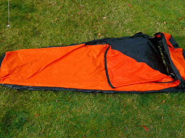
•MLD bivy. Black Sil-nylon bottom, orange Epic top. (Happy Halloween!) Used once in a snow cave. Excellent condition. No bug netting, right hand half-length zip. 10.2 ounces on my scale. This is a $225 bivy and is perfect! $150
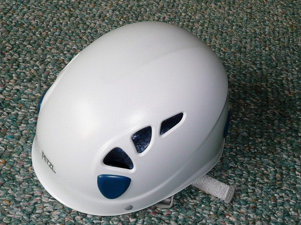
•Petzl Elios helmet. Size 2 (53-61cm. – 20.9-24 in.) Used once. No rock has ever touched it. $35
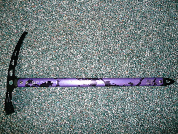
•Omega Pacific Evolution Ice Axe. 60cm. Girly PURPLE! Used twice for training only. $35
-
BTW...the wide-mouth Nalgene Canteen is THE way to go when using a bandana to filter. (Light weight too!) It's pretty damned hard to fill a narrow-mouthed platy when scooping water up.
-
Banos,
You'll do just fine with tablets in the Baileys. I almost exclusively use Micropur tablets.
http://www.katadyn.us/brands-products/katadyn/micropur-purification-tablets.html
Those and a bandana to filter out the floaties.
-
Although I can’t give you info on Bear Pass over to Olympus, I did do the Bailey Range in ’05, avoiding Cream Lake like the plague. Here is the WTA trip report (Including photo links) which describes the method to avoid Cream Lake on day #4:
http://www.wta.org/go-hiking/trip-reports/tripreport-2005071620
The specific route had previously been described to me by another CC member:
“The trick is to cross over the ridge before it makes a big left turn:
From the catwalk you walk below the main SE trending ridgeline. Go past 11-Bull Basin, and the trail eventually takes a sharp left at the corner, to the east. This is the major ridge at peak #5988. There is a minor ridge (WSW trending) just before that corner. You are on a well worn path in a large talus field when you see that minor ridge. The minor ridge line has trees along its spine, except for a gap near the top. On the topo, the top of this ridge gets to a large flat area. Your destination will be there, at peak #5796 on the older USGS map.
Now here's the part where many people have a hard time. Leave the well worn path that seems to continue forever and instead aim for that gap up in the tree line at the top of the minor ridge. Work your way up the steep but grassy cirque bowl to the obvious treeless gap. From there a game trail gets you the last 100-150' to the top (flat area, good camping, there's generally snow and water in a depression up there), then cross the major ridge to the east and look below to Stephen lake (big lake NW of Stephen Pk), or preferably tarns above the lake, warmer for swimming. Scramble down the loose talus from here and cross N, just above of Stephen Lake. Then climb up a gully system to NE of Stephen Pk.. (easy scramble to summit if so inclined), continue around the E shoulder of Stephen Pk, staying at about the same altitude if you can. Cross a couple of snow and rock fields as you head south, until you reach the ridge on the south side of Stephen Pk. From there simply walk along the ridge line game trail until you can find “easy” descent into Ferry basin in about a mile when the game trail ends at a cliff face.
Another way is to ascend Carrie and then traverse the ridgeline all the way to the flat area mentioned above. I've never done it all, but did come back from the flat area to Ruth Pk (along the ridgeline) once. Viewed from Carrie summit, the traverse from Carrie to Ruth looked easy.”
You can contact me at "hoosierdaddy810 at hotmail dot com" if I can help with any more info.
-
This summer, several of us are going to attempt to find a certain waterfall in the Olympics. We expect to have to use rope in a few places; mainly for jumaring, rappelling and hauling, so I’m thinking that I need to look for static rope instead of dynamic. So, first question...is static rope appropriate for that purpose?
Next, weight is a HUGE issue with me, but so is safety. I was wondering if someone could recommend a specific rope brand that is very lightweight while quite strong, the most probable usable length, dry vs. non-dry ropes, diameter to weight ratio, sheath construction and what general properties I should be looking for when I buy it.
-
This is an interesting thread.
It seems obvious, however, that Hoosierdaddy's proposed project of "bushwacking up the Queets Vally," while an extremely laudable, but perhaps also an inadvisable idea, is entirely unrelated to Mr. Blackhawk's question.
Not at all...I'm simply looking for additional information like Blackhawk is, on that shortcut between Skyline & Queets basin so that I don't have to bushwack. As for an "inadvisable idea", who are you to judge?
-
I, also would appreciate any info that exists on that route. I've scoped it out on Google Earth, but I'd love first hand information!
Several of us are in the early stages of planning for an 11-day trip into the Queets in the summer.
The thought of bushwhacking up the Queets valley for several days straight doesn't sound quite as appealing as only a 5 hour bushwhack.
-
-
Some people just did it on Monday the 27th and posted this trip report over at nwhikers.
-
Good route info and waypoints are in Olympic Mountains, A Climbing Guide
-
I think this may be problematic. Expecting both people to stay on their backs in order to stay inside the hoods throughout the night isn't realistic. There has to be some movement allowed if you expect them to spoon. Maybe a detachable down-filled hood?- integrated permanent down-filled hoods. These will be slightly lower volume hoods than we put on mummies since the shoulder girth of this bag is pretty slim.
Now this I like! Great idea!- Permanent collar with yoke. The collar is specially contoured to fill the space between the shoulders of the occupants. This reduces heat loss through the large opening at the top of the bag.With some tweaking and if the price is right, yeah I would probably buy it.
-
Rope is gone. Harness still available.
-
My adult son is wanting to sell what remains of his climbing stuff. He tried the sport, but didn't like it after all. The equipment has been used only once and is good shape. PM me if interested.
1. Sterling 10.2 MM, 50 Meter Dynamic Rope $60
2. Petzel "Clyde" Harness size XL $40

-
Looking for a GOOD quality, down, winter bag rated to at least minus 5. (Preferably lower cause I'm a winter weenie!) Anyone have one they are just dying to part with?
-
This is the W.T.A. link to my report.
Enjoy everyone!
http://www.wta.org/~wta/cgi-bin/wtaweb.pl?7+df+2005071620+time+trails+
-
Actually I'm in the process of writing my trip report as we speak. It's kinda long and I'm not sure it's appropriate for a non-climbing report to be posted here, so I'll probably post it on the W.T.A. site in a few days when completed.
But, to quickly answer your questions....
The route between Mt. Carrie and 11-Bull Basin traverses four dirt/scree gullies with very loose, narrow and trecherous footing in most places. It's only about 2 miles but took us 4 hours due to having to concentrate on CAREFULLY placing each footstep so as not to fall to your death down the slope!
YES!!! Crampons and ice axe were both needed in several locations. Basically about any snow (that wasn't level) we ran across from the south side of Mt. Pulitzer all the way south to Bear Pass was rock hard and very icy! We were damn glad to have the crampons and axes even though they were dead weight before and after those sections.
The only snow in the Elwha snowfinger was found to be at the snowdome which required a steep dirt scramble up the north side of the gully, pick your way gingerly across the crevassed top, (staying to the north side cause the ice was thicker underneath you) and then slide back down the dirt to the gully on the far side.
And, oh yeah....The Catwalk. There are several <possible> routes across it with only one being the correct one. If you find your ass hanging over empty space with the valley thousands of feet under you, you are probably on the wrong route! We found that following all the goat hair that is stuck on the bushes was the correct route! (Really!)
Hmmmm....what else. No water between Boston Charlie's Camp and 11-Bull Basin, and no water from just south of Mt. Pulitzer and Dodwell-Rixon Pass. The skeeters will surely carry you away and butcher you if it weren't for the weight of your pack to hold you down, so bring plenty of Deet! The wildflower show is outrageous right now. It was hotter than hell during the day and we ran out of sunscreen. (Once during a break near Bear Pass my little el-cheapo thermometer read 104 degrees and at that instant my Bic lighter burst in my pack!!!)
Ask more specific questions if you have them, I'll try to answer.
HD
-
I just returned two days ago from doing the whole Bailey Range north to south, and can't imagine anyone doing it over just two nights!
 Once crossing The Catwalk, the route turns to shit that traverses multiple loose dirt & scree gullies with enough room for at least half of your foot width above a 2000' vertical drop for about the next 5 miles or so before it simmers down to just semi-crappy at 11-Bull Basin.
 No kidding, a 5 - 7 mile day on the Baileys is about all anyone would want to do and I usually pride myself on being an U.L. hiker that could "normally" do a 18 - 22 mile day on trails. We had one very intense (and HOT!) day that went ~9 miles from Mt. Pulitzer, down the (snowless) Elwha snowfinger and ended up at Happy Hollow Shelter on the Elwha trail at 10:30PM. I thought I was gonna die!
Good luck and please remember me in your will!

-
Clintoris: I'm doin' the Baileys from the North to include the Skyline Trail beginning on July 17th. When are you going & what route/direction?
-
Here's some very disturbing beta I found on the Mountaineer's website as posted by Kirkalm:
-
Noob to the boards here. This summer I'll be southbound on the Baileys and want to get over to the Skyline trail without descending the Elwha snowfinger to Low Divide then go all the way back up again. Does anyone know a doable Class 3 or lower route?

[TR] Camp Muir White Out
in Mount Rainier NP
Posted
Josh, why are you bringing this up again after 13 pages of "interesting replies" over at NW Hikers?
http://www.nwhikers.net/forums/viewtopic.php?t=7974581&postdays=0&postorder=asc&start=0