


gslater
-
Posts
326 -
Joined
-
Last visited
Content Type
Profiles
Forums
Events
Posts posted by gslater
-
-
This may not be where this question belongs but here goes/I am looking for advice on the purchase of a new bivy? any comments...
There's a very recent thread in the Gear Critic forum about that very subject.
-
What authority does a ski area have to say one can't descend into "their" terrain? Does the legal situation which allows the ski area to operate on Forest Service land also require the purchase of a lift ticket to be within that boundary, or is it left to the discretion of the ski area?
-
A little bit of Googling found a site that listed 3 new packs for spring/summer of 07. They're the Flash, the Quantum, and the RPM. Also shows a significantly updated version of the Sphynx.
-
Was doing a little pack shopping today, and was told by a young know-it-all employee at one shop that BD is adding 5 or so packs to their lineup in the "next few weeks". Knowledgeable people at other shops claimed to not have heard this? Anyone out there know anything about this?
-
Been climbing in the sierra Nevada sence I was 10 and am fully prepared.
If your experience is in the Sierras, I think you'll be astounded by just how crappy the "rock" is in the 3 Sisters. You could make yourself more prepared by practicing hiking up loose gravel piles in your area.

-
As usual, the Japanese are years ahead of the west...check out this guy who spent 24 days hibernating after getting lost in the mountains.
The best snow survival skill is to keep a worthy ex-Minnesotan around so that he can dig your snow cave for you. Everyone knows that...

-
I'd climb with Phurba. That dude is a badass.
-
Abdicate your responsibility for planning, skill, fitness, decision-making, routefinding, looking after each other, etc and what have you got left?
Would probably be cheaper just to hire someone to whip you while you spend a couple of months nearly non-stop on a Stairmaster.
-
If things continue to go the way they are, and the standard routes keep getting more and more commercial traffic with people that have no clue what's going on, it's only a matter of time until some disaster way worse than 1996 (or this year) happens.
It's easy to envision a scenario with a couple of dozen people taking a big ride when their "fixed" line becomes not-so-fixed in response to someone falling. Everyone is so casual and out of it that I'm sure they'd all just get popped off the mountain.
-
NEVERnevernever........EVEReverever.........RESTrestrestrest....
LOL. My wife is sick of me walking around the house repeating that over and over. Was sorta glad to see Frenchie lose some flesh; he was kind of an ass.
-
I have an old casio pathfinder. I have had it, used and abused it for 7 years now. changed battery 4 times and it is very accurate. very happy with this watch. At the time I paid 150 range.
I also have an old Casio Pathfinder. Was on sale at OMC for $99 perhaps 8 or 9 years ago. Should have bought more at the time for gifts or whatever for climbing friends. I've taken it everywhere, and its performance has been flawless. I think I've replaced the battery twice. It seemed like a really big watch at the time, but compared to modern altimeter watches, it's not so big. Its biggest drawback is the fact that it's from the time before electro-luminescent watch faces, so it's got a weak-ass little bulb for a light. Damn near impossible to read at night, so I always have to shine my headlamp at it. Pain in the ass.
This poor night readability inspired me to go looking recently for an updated altimeter watch. Suuntos are everywhere, and they're generally pretty fine products, but the alarm volume is so ridiculously low for a "climbing" watch that I can't even believe it. So low, in fact, that it caused me to rule out all Suunto products. And I tried 'em all. Spent a bunch of time at various stores setting and testing alarms on all the Suunto models I could find. The alarms all sucked.
The Highgear products seem pretty good for the money, with big, legible displays, and substantially better alarm volume.
The Origo watches (available at REI) are also a good value, and similar in style/functionality to the Highgear products. I believe I found somewhere that Origo is a brand that is part of the larger Silva brand.
Looked into what Casio has to offer these days, since I had such good luck with my last one. They're a bit harder to find. Surprisingly, Sears is one of the main places that carries them. A bit large (like the Suuntos), but lots of nice functionality. Good alarm(s). Nice backlit display. Solar-powered versions. Automatic atomic timesetting, and so on. Found one particular model that met what I was looking for. Was wandering through Costco, and checked the watch case. Lo and behold, that model was on display and available, so I bought it. $169, versus an MSRP that's something insane like $300. They're still available at the Costco in lovely Tigard, OR, and perhaps at other places.
-
When will the pictures from James' camera be made available for all to see?
I saw a news report today that his family has decided not to release them to the public.
-
Coming down from Camp Muir in a whiteout is a classic place where a compass is useful.
As is coming down the south side of Hood. 180 mag, if I recall correctly...
jfmctlaw - In a whiteout you can't exactly use a map and compass to figure out where you are, but you can certainly use the compass to ensure you're headed in a certain direction. You could also use the GPS to figure out where you are and which direction to head to the next target, and use the compass for actual en-route navigation.
-
Thanks everyone.
We got a flurry of angry emails the other day ago from some guy who was unhappy that a few of his posts disappeared. He wanted to know who the CEO, President, Senior manager, Customer Service Representative where. I told him due to our recent SEC filing for IPO that I couldn't immediately reveal that information.
Must have been the same jackass who was complaining about his lack of 1st amendment rights here on CC.com. I told him he had no rights here, and to just suck it up.
-
don't MLU's only work on Mt. Hood? I have never hear of them being use any place else.
Yup, Hood only. That's what the 'M' stands for. "Mt. Hood", not "mountain".
As for the PLB, I think it's borderline criminal that the $600 unit shown above doesn't include an internal GPS receiver. It'll only send out GPS coords if you have a separate GPS that can talk to it.
-
Does anyone know how much experience any of the three guys had specifically on Hood?
I believe it was in Jerry Cooke's ("fuggedaboudit's") posted inquiries on this web site back in November that he said none of them had ever been on Hood.
-
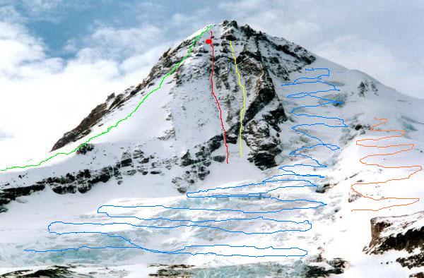
So Mr D, where is Cooper Spur and the "gullies" in the pic we keep hearing about (for those of us who are not that familiar with Hood and these routes). Thanks
Grabbed these pics from other posts in recent days, and used MS Paint for a couple of VERY quick & dirty edits. I hope the original pic owners won't object to my use of their products.
Green line is Cooper Spur. Red line is left NF gully. Yellow line is right NF gully. Broad blue squiqqle area is the Eliot Glacier. Orangeish squiggle is the Snowdome.

-
1. Is there an online resource anyone knows of that shows the topography, with parts labeled?
2. Would Tie-In-Rock be THE highest point of the 'summit' where the elevation measurement is taken, and where most climbers who wanted to say they had been to the very top would want to reach? The media keeps saying that the caves were just below the summit, yet the helo pics show what looks like a very wide ridge that you could walk across for awhile. Tie-In-Rock is not like that. It's a pointed rock.
3. Are the huge ragged rocks where it showed the airlift taking place the pearly gates? Or are those big nasty rocks part of the hogback? There appear to be more than two, and its been said that they tried to decend a path between them and couldn't find it due to conditions. I don't know which two are the 'gates' and haven't seen all of them shot in one photo with a camera that's wide enough. That must be the south side cause all the postcard pics show the n. side.
4. I don't know that I buy the sheriffs account of what happened, that the 3 spent the first night together in a cave, especially after hearing the interview with the first rescuer to reach Kelly. I've heard for a week now that the south side is so much easier to climb than the north side. Could wind conditions and visibility on the south be SO much worse than the north, that whatever the reason was that the two climbers felt they HAD to get off that mountain immediately would cause them to backtrack and go down a very difficult descent? Is that consistent with typical of Pacific storms, that the wind encircles around from the west to the south, rather than the north? And if they tried to go back down the same path they came up, where are the foot tracks?
5. I've read how many people 'set out' to climb Mt. Hood every year, but that doesn't mean they go to the top. I've seen pictures of people in t-shirts and shorts climbing Mt. Hood and standing next to glaciers at the top. Some pics had MINIMAL snow at Elliot, surrounded by dry rock. What months are best to go to get a happy medium between some snow, but no where near what there is now? Can you EVER hike/rock climb to the very top without climbing 'gear' or hanging from anything? Is it considered so dangerous and narrow, such that if you fall to one side, you're gonna keep falling awhile and potentially get hurt? I'd never want to get hurt up there under any circumstances. I'd want to go to the top, but how high should I go and when should I do it? How many hours up and down if you camp or stay as close up as possible to cut down time the next day? Where's the closest to the top they'll let you camp out at night if you took sleeping bags so that you didn't have to do both directions in one day? or is that possible?
6. I heard a rescuer say today that you could last through several days in a 32 degree snow cave when it was -30 outside. I had assumed that the severe cold is what made them take desperate measures to save their lives. Even with a food shortage and a severe arm injury, what would then cause you to not just stay put for longer?
7. Are anchors used to go either up OR down? What do we know as fact, based on a Y shaped anchor pointing downward? I googled pics on anchors and found nothing like that. I can't envision them using that for anything. They said it was to hold them to the side of the mountain during a storm. Really? In a Y shape pointing down? These weren't window washers. Would they have used other ropes to tie to the anchor to lower themselves down a level, then leave the anchor there? What do they then do for ropes if needed again? The pic looks very steep unless the cam was pointed straight down at the ground. I wish we could get some pics of that thing in relation to the side of the mountain. Every bit if info just opens a can of questions for me. This is like a mystery and I feel like a detective. This isn't suppose to be like the Jon Benet case.
8. The sheriff said that aluminum anchors were dug into snow. Bad choice of words perhaps, but snow won't hold any weight. Did he mean rock beneath snow? What's a good web page for 'anchors 101' cause right now I don't even know how people get those hooks into rock, and I certainly can't see doing it in a blizzard conditions.
Hell, I've got nothing else to do, and I'm a pretty fast typist, so I'll take a shot at some of these. Hope it helps, and hope I don't screw it up due to it being late and me being tired. This being CC.com, I'm sure someone will let us know if I slip up.
1) I don't know of a good resource off the top of my head. It can be difficult to compare pictures of glaciers if you don't already know them, because they look very different at different times of the year, with different amounts of snow on them.
2) Tie-In Rock is not the summit of the mountain. It is a point pretty high up on the Cooper Spur ridge (about 8800' elevation) that is the traditional point where Cooper Spur transitions from a "hike" to a "climb". It is where the Spur gets much steeper, and beyond that point, it's climbers-only. Very hard to identify distinctly when covered with snow, as things are now. The ridge that had all the people you saw from the helo is a ridge that extends from the very summit toward the SE. Off the back (non-sunny) side of that ridge is the top of Cooper Spur.
3) The "Pearly Gates" are a couple of hundred feet below the actual summit. There's a fairly narrow (20'?) slot between the rocks that is the standard path up to the top from the south side route, but there are some alternate routes between the rocks, depending upon snow conditions. If you've been to the top of Hood before, it's pretty easy to find the correct route down through these. In bad visibility, and never having been there before, it would be hard. There was a very experienced group of Hood climbers that spent some quality time in a summit snow cave a few years ago, largely because they couldn't find the correct route down in bad conditions.
4) The strongest weather systems that hit the NW are those that come ripping basically straight onshore, west to east. This puts the standard south side route right in the teeth of those winds. The Cooper Spur side is normally, I suppose, sort of out of the worst of the wind. But that side is also therefore heavily at risk for avalanche danger because it's where lots of blown snow gets deposited. This blown snow could easily cover any tracks. In minutes.
5) The "normal" climbing season is late spring and early summer. Weather is better, and the snow is consolidated. A climb up Hood can vary between a seemingly very casual hike and, obviously, a brutally harsh, serious undertaking. Lots of people climb it every year with essentially no equipment. Not my way to do it, but some do. Even the easiest route has some moderately steep terrain, and all is well as long as you don't fall. Conditions can be really nice below, but icy above, and vice versa. One of the reasons people climb the mountain in varied seasons is to get experience with a wide array of conditions. You can camp out pretty much anywhere along the route (outside the ski areas), including the top if you're so inclined. Spending a night on top is not a rare thing for people to do in good weather.
6) A snow cave can be pretty cozy and toasty, albeit humid. If you've got protection from the moisture and coldish temps, you can live in one for a very long time, as long as you've got food and water. Especially water. Gotta have a way to get water. If it's pretty warm inside, you could theoretically drink dripping snow melt, but that's not enough. Best would be having a stove (and pot) to melt snow to drink, but obviously, you're then limited by stove fuel quantities. Any "desperate measures" (leaving a snow cave) taken by these guys is probably related to not having a way to get water, or related to realizing the onset of hypothermia, and knowing that they have to do something.
7) Anchors are indeed for going both up and down. "Going up" can suddenly turn into a "going down" if someone falls, and anchors are designed to hold one or more people if they fall. That 'Y' shape is pretty common for a snow anchor. I don't know if the alleged 'Y' that has been shown in pics is really their anchor, or something else, as Iain indicated. I'd probably trust Iain on this one. Anchors do often look sorta 'Y'ish because there are two pieces or equipment buried in the snow, and then there is rope or slings or something attached to the two pieces of equipment, and then they come together into a common attachment point on the downhill side. So really, it's typically more of a 'V' than a 'Y', but a 'Y' could work as well. If they want to lower themselves down the mountain (rappel), they run their rope through that common anchor attachment point so that it hangs from the center of the rope, hang off both strands of rope to descend, and then once reaching the end of the ropes, untie from it and pull on one end of the rope to bring it down to them. The anchor stuff up above, unfortunately, will have to stay there. If they want to repeat this lowering process, they'd have to build another anchor. Obviously, doing this over and over requires a lot of gear, and nobody carries that many pickets with them. There are other ways to build anchors in snow that don't require so much equipment, but the pickets thing is arguably easiest.
8) The anchors they would have probably built didn't have anything to do with rock. They were most likely snow anchors, probably built with what we call "pickets". These are typically about 2 feet long, made of aluminum, and with a 'T' cross section. You attach a strong sling to each one, bury them in the snow a little ways apart from each other, and then stomp down the snow over them. The snow ideally then gets kind of hard, and gets stronger than you'd ever believe. The slings extending from the pickets come to a common point, which is the main anchor point. In strong winds, I'd definitely create an anchor like this if I were going to be spending any time in one place standing up, such as working on a cave. That sort of anchor could also be used for lowering people down the slope, so any anchors they find up there could mean a couple of different things.
Maybe all this belongs in the Newbies forum, but it was asked here. OK, time for bed...
-
And although I COMPLETELY understand this is a good time of year for this ascent, why are we hearing from crews at Hood River that this climb is normally made during May-July season and rarely at winter? Is this another misnomer caused by more speculation?
The Cooper Spur route is "usually" done as part of the "normal" May-July season. The north face routes are not. They're usually late fall or early winter. I think it's just the usual confusion over route names and so on.
-
Bill O'Reilly stated on his Fox show that he thinks climbers should be banned from climbing or going up on mountains when weather is or could be bad.
It's not just that worthless piece o' crap O'Reilly. There was an online poll on kgw.com (Portland TV station) today asking essentially the same question. I'm disappointed to report that at the time I checked, 73% of the poll participants agreed with O'Reilly. F'ing pathetic.
I worry that people with influence and control over access will see these numbers and feel the need to act accordingly.
-
A good resource for those wanting more all-around information on Mt. Hood, including a lot of historical information and also information on past incidents and rescues, is a book by Jack Grauer called Mount Hood: A Complete History. ISBN number is 0-930584-09-0. Unless you're in Portland, it's probably not available in your local bookstore, but you can probably find it at powells.com.
-
My wife was asking me yesterday about why someone wouldn't take an avy beacon along instead of an MLU. Had to think about the pros & cons of that one a bit. I can see a well-equipped team perhaps taking along one avy beacon on a climb, even if you don't expect avy conditions, and leaving it turned off. If you did end up having to ride out nasty weather and wait for the cavalry to come, telling them roughly where you are and then turning on the beacon could definitely be helpful to searchers. I don't think I'd want to necessarily leave it on full time however, wandering all over the mountain, in case someone else in the area actually needed to do a search.
-
gslater-
The first cave was to skier's left of the spur proper, heading towards the left gully. The second cave, were the climber was found, was about the same elevation but more east, on the spur, by a large rock. It was big enough for several people. The tracks leading to this cave meander over to the cliffs of n-c headwall/spider, then a hard traverse back over to cooper spur again. There do not appear to be any further tracks below these locations.
Thanks. That makes more sense now. I never heard any real statement about where the 2nd cave was. Heard the sheriff mention setting up a 5:1 system for the recovery, and couldn't figure out why that was necessary if the 2nd cave was on the south side close to the helo zone. Just goes to show what happens when I assume too much...
-
No freedom of speech here.
No amendments to the Constitution held here.
Yup, you're right. Suck it up.
Ice on Sahalie Falls (Mount Hood area)?
in Oregon Cascades
Posted
Probably pretty rare. I've snowshoed in that area a number of times, and have never really seen any ice there.