-
Posts
4 -
Joined
-
Last visited
Recent Profile Visitors
The recent visitors block is disabled and is not being shown to other users.
DFMedia's Achievements
-
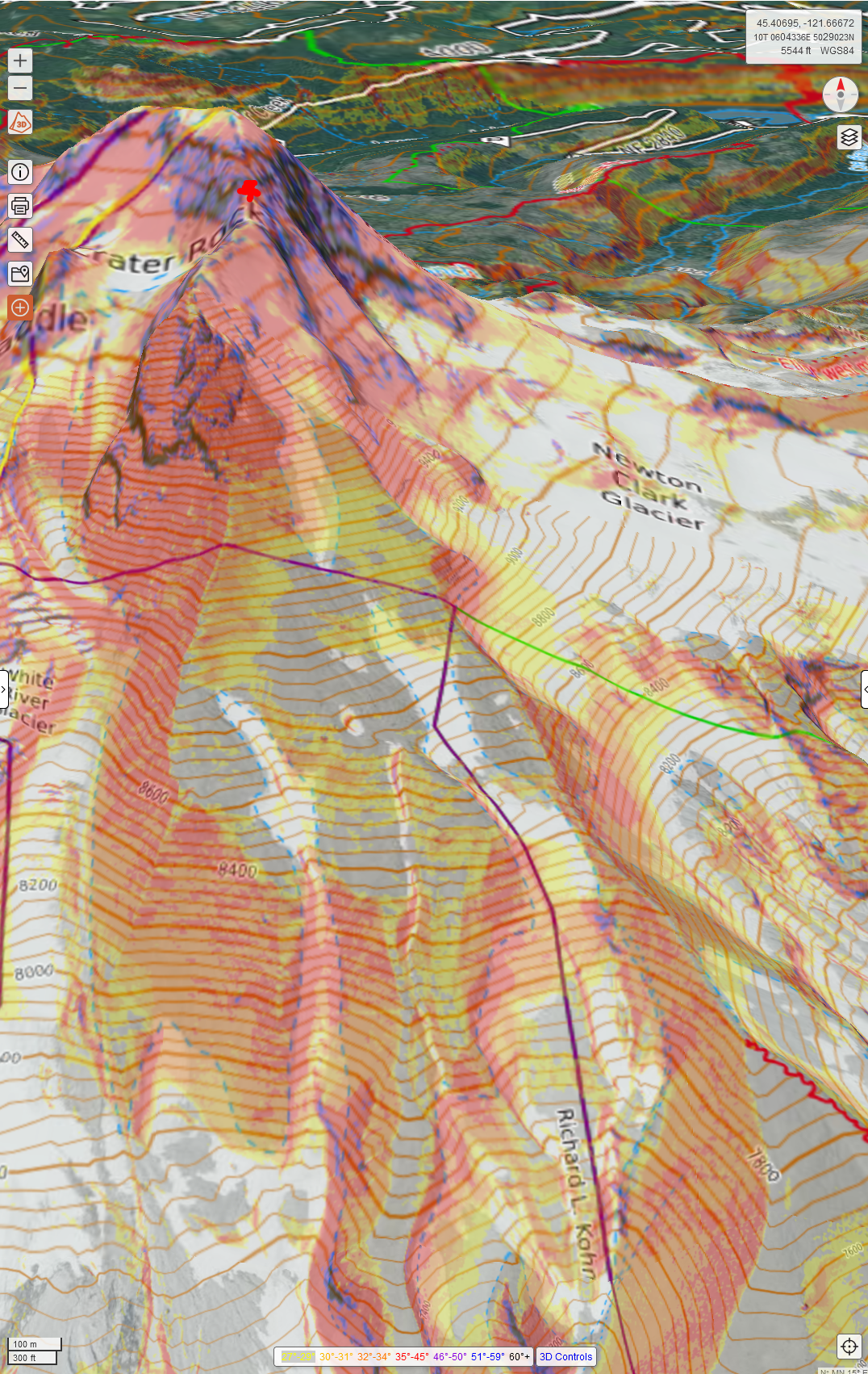
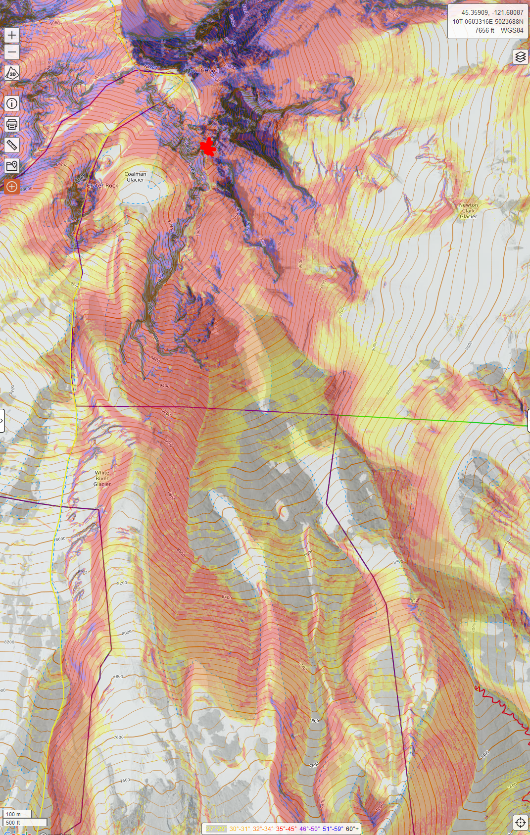
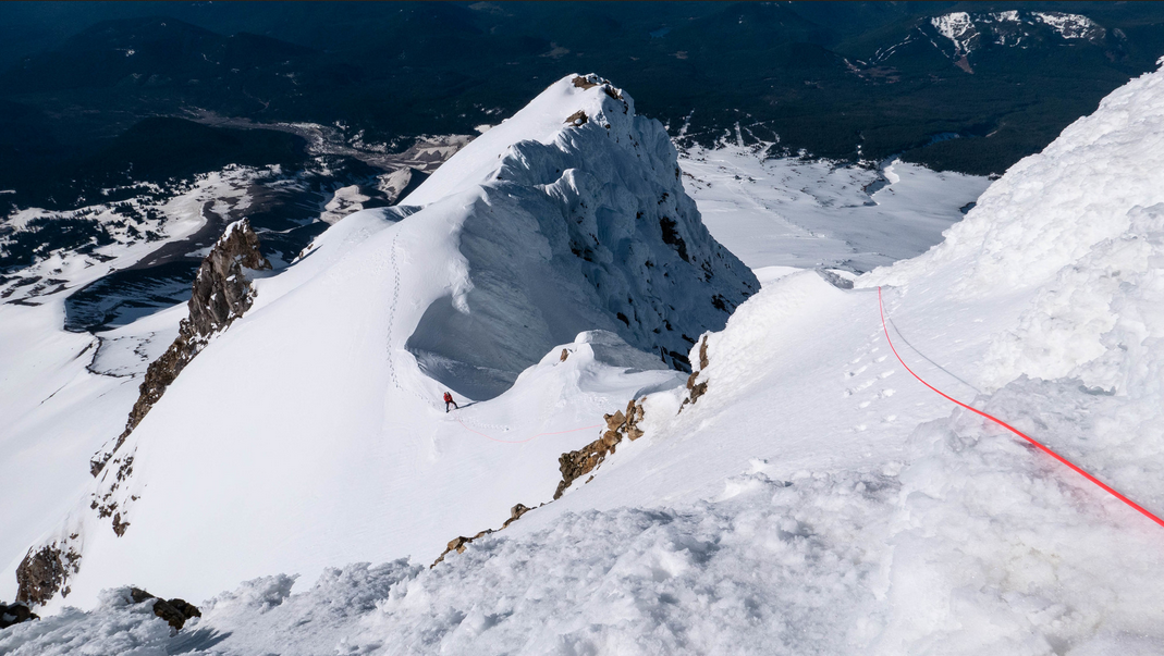
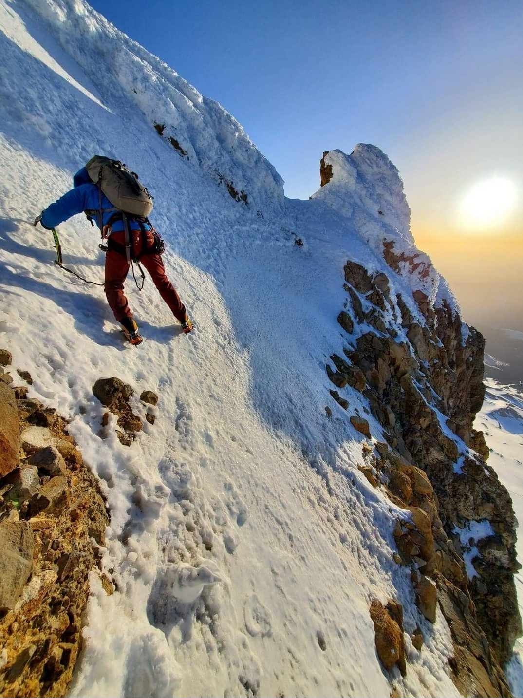
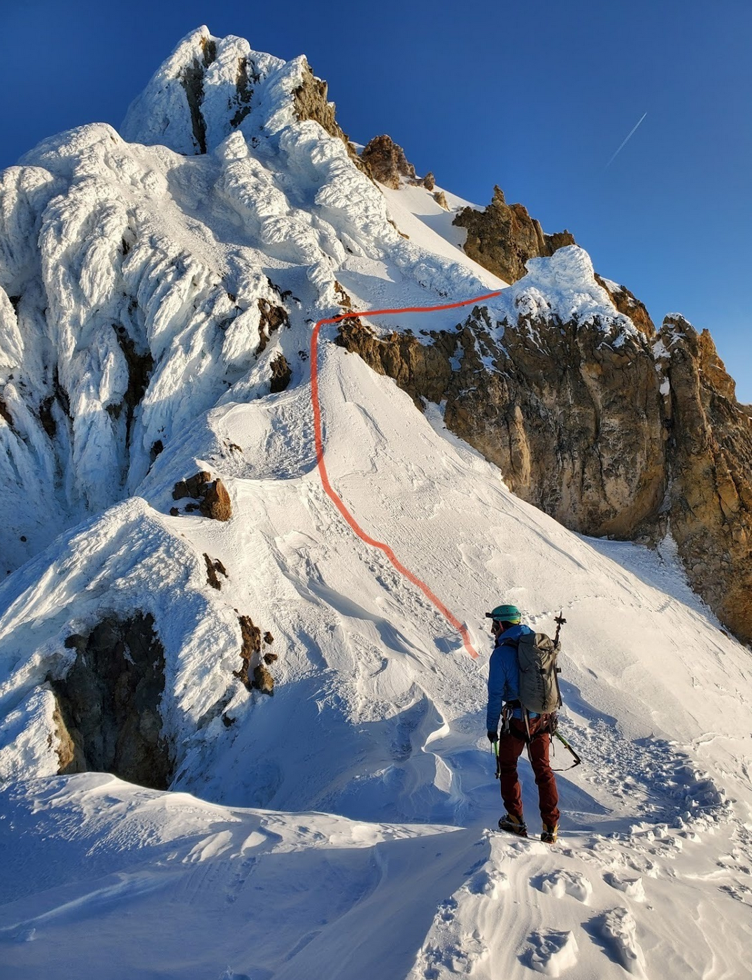
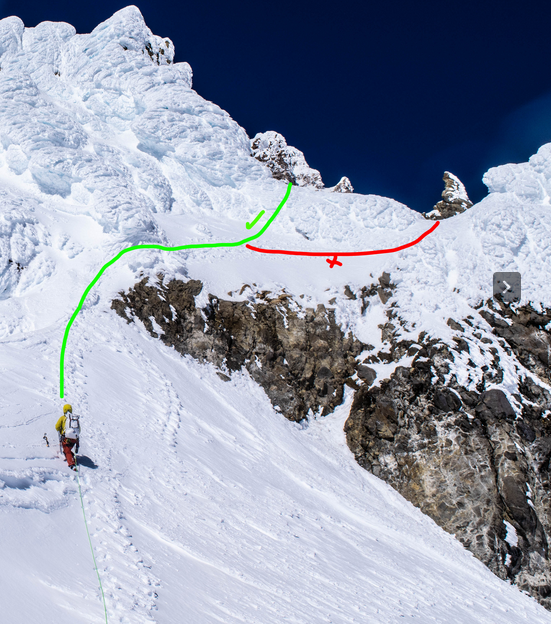
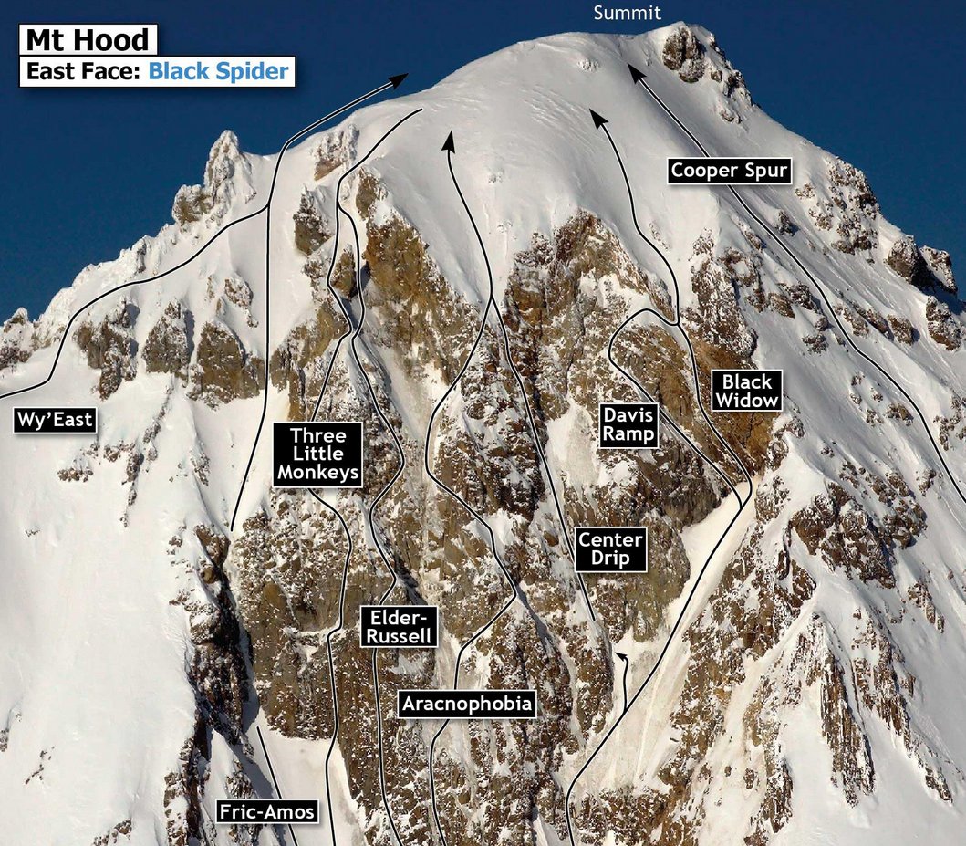
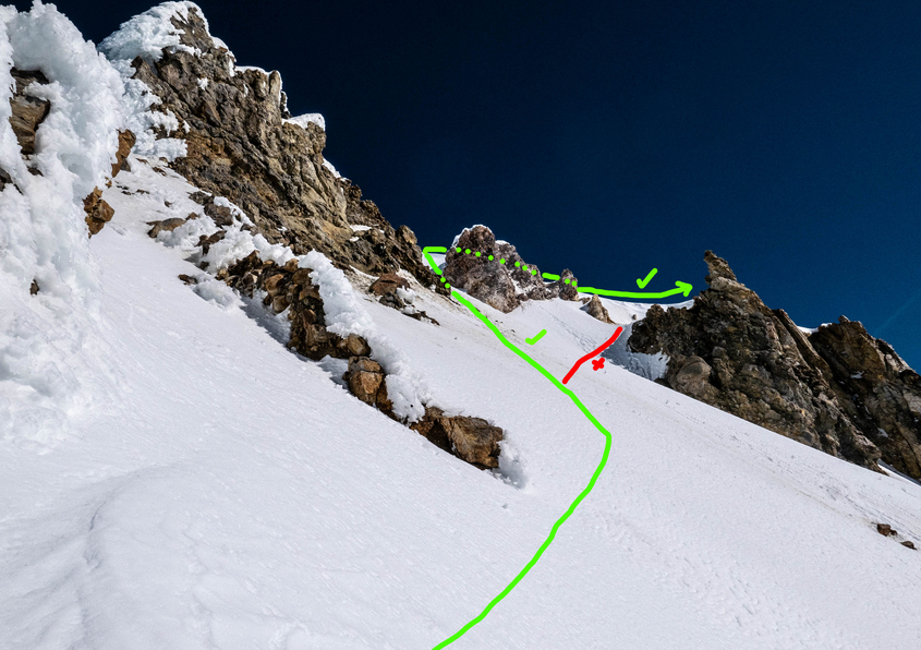
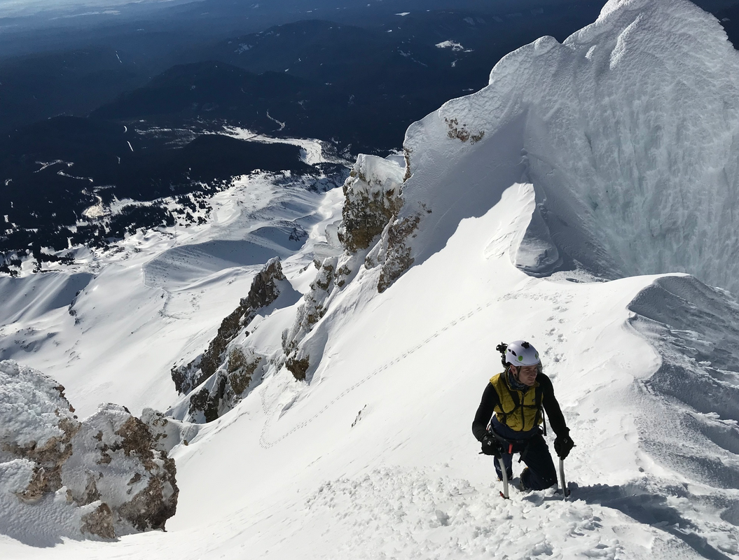
Thanks for all of the information it has been really helpful! After a lot of research, I think that the timing of a summit and downclimb via a route as technical as the Wy'East with skiing the Newton Clark headwall is going to be too tight to have a good margin for safety. If I had experience climbing the Wy'East route, and knew exactly how long the climb and downclimb would take it might be a different story. However, I don't want to rush the climb (and downclimb) of a route as exposed as Wy'East, nor do I want to ski the Newton Clark headwall when there is high risk of causing a wet slab avalanche. Especially when (depending on the year) there is some crevasse hazards on the Newton Clark headwall. At the end of the day, for me, its better to plan these two objectives on separate days to ensure that risk is kept within a manageable zone. @bedellympian you are correct, the fact that the Newton Clark headwall is one of the 50 classic ski descents did factor in to my decision. I had the opportunity last year ski a different 50 line (summit Young's Peak in Rogers Pass, BC and ski down the Seven Steps to Paradise). It was the best back country run I've ever skied, and figured it would be great to see if another 50 line is as good. @Fairweather Thanks for the suggestion re the Cooper Spur, I will look into that line a bit more for sure! Since I have spent a considerable amount of time researching the Wy'East route, and because everyone on this board has been so helpful, I figured it would be a good idea to consolidate some of my research here to show how serious the route is and to assist anyone else trying to climb this route. I will state that a summit via the Wy'East route is a pretty serious objective with a fair amount of exposure. The below research is meant to assist people with understanding the seriousness of the route, and to help them understand what they would be getting themselves in to if they do attempt it. I make no warranties or representations about the accuracy of the information. Any potential climbers need to also conduct their own research and make an informed decision on whether or not to take on the risk, and whether or not they have the skills necessary to climb it. Getting to the first Crux: The first resource should be the Mt Hood Climber's Guide by Bill Mullee. It gives a great overview of the route with some general descriptions. Although I found the descriptions and photos to be lacking in detail, it definately gave me a good starting place to do research. The guidebook suggests leaving from Timerbline and crossing the White River glacier at 7100'. If leaving from Meadows Caltopo maps show a few paths that appear reasonable. I have highlighted the first crux on the map with a red star. (Map from CalTopo with Google Satellite baselayer, the map builder overlay, with countours and slope angle shading. I've attached the top down map as well. same parameters as the map above, just with 3d turned off. When climbing to ski the Newton Clark Headwall, Cody Townsend and Michelle Parker chose to start at Meadows: When climbing the Wy'East route and skiing from the summit (including the Newton Clark headwall - absolutely crazy), Michael Wirth also left from Meadows: There are some really good photos on MountainProject.com of some of the aspects below the first crux. Photos and information here: https://www.mountainproject.com/route/106202622/wyeast Chris Comair has a blog post on climbing the devil's kitchen headwall and Wy'East. I found the photos and information concerning the Wy'East route to be quite helpful. it can be found here: https://gethighonaltitude.com/2020/05/15/mt-hood-flying-buttress-wyeast/ There is one particular photo I found in Chris' blog post that shows the terrain before the first crux well (photo appears to have been taken from the first crux looking down): (Photo by Chris Comair from his blog referenced above) The First Crux: In terms of the first crux (the traverse) I found a few good pieces of information and some photos. There were two photos posted by Scott Branscum on the MountainProject.com link referenced above: (Photos by Scott Branscum uploaded to MountainProject.com link referenced above) It is worth noting that the Mount Hood Climber's guide by Bill Mullee states that it is usually best to stay low on this traverse (which appears to be the route advocated for in Scott's photos). In his Blog post, Chris Comair suggests a different route over the first crux than the route suggested by Scott in his photos. Chris is climbing the route at a different time of year than Scott, but his logic behind the route choice (while not stated explicitly) appears to be to minimize the size of the fall if one occurs by climbing above a smaller cliff. Chris advocates for this route: (Photo by Chris Comair in his blog post referenced above) The Rising Traverse: Once above the first crux, there is a rising traverse to the summit. According to the Mt. Hood Climber's Guide by Bill Mullee, there are some gullies to the climber's left (above you)but these are dead end ice chutes so don't be lured upwards too soon. A general map of the traverse can be found below (Note how exposed this is, an avalanche or uncaught fall on this portion of the route doesn't seem survivable) (Photo from Mt Hood Climber's Guide written by Bill Mullee) I have scoured youtube to try to find different perspectives of climbing the route to try to get an idea of what protection people are using for this rising traverse. At least one video showed roping up and using pickets for the rising traverse: The Chimney: After the traverse is done and you've reached the chimney, Chris's blog suggests going straight up instead of continuing to traverse: (Photo by Chris Comair from his blog post referenced above) It seems like once you reach the chimney, keeping a bit climber's left, its straight climb to the east summit ridge: (Photo by Bob Pool posted to MountainProject.com at the link referenced above) Here's a video showing the top portion of the route: another video showing the top portion of the route: Other helpful links: - https://www.summitpost.org/wy-east/157708 - https://mazamas.org/activity/70/ If I've missed something feel free to add it. Again, information is provided to show how serious the route is and each person needs to conduct their own research to decide if they are capable of climbing it. I make no claims about the accuracy of the information either, I have merely compiled what I found into one place. Climb at your own risk.
-
Thanks for the Information! @Fairweather I was never planning to ski the route, nor claim I had. It has been done, but by those significantly more daring than I? My question regarding the ski was more aimed towards would it be better to accomplish my objectives in one session or two? I have 2 objectives, (1) summit and (2) ski the Newton Clark headwall. Would it be more reasonable to complete both objectives in the same session (by climbing Wy'East, down climbing the same route back down to the Newton Clark headwall and skiing from there); or is the down climb of the Wy'East route sketchy enough that I should consider coming down old Chute and then climbing and skiing the Newton Clark headwall on a different day?
-
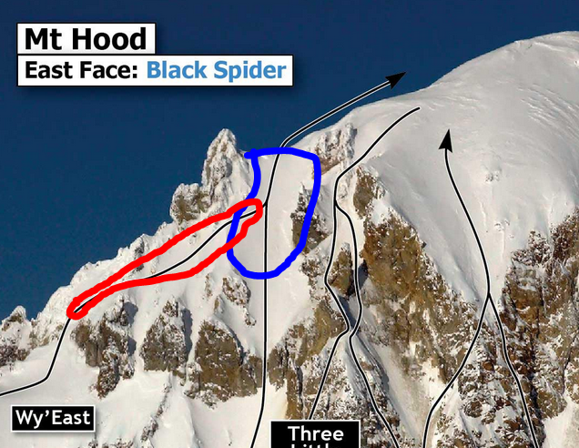
Thanks for the information guys, its very helpful! I was initially planning to climb this early May, but it seems like this route may be safer with more snow, so would mid to late April be a better idea? Seems like a balancing act between having enough snow to make self arrest and climbing easy, but not so much that there is a risk of avalanches (avalanche seems like death). Is this a common enough route that there will already be tracks by then? Is it common enough that there will be people climbing above? Also, it seems like very few people down climb this route, and instead choose to down climb old chute. Is there any particular reason that down climbing Wy'East is not recommended (other than the obvious exposure)? If you were in my position would you down climb Wy'East to ski, or would you plan two separate days (one to summit, one to ski the Newton Clark headwall)? @Fairweather When you are referring to the chimney, are you referring to that steep section right before the ridge (marked in the annotated map below in blue)? When you belayed it, did you just use pickets as protection? (Photo from Mt Hood Climber's Guide written by Bill Mullee) Regarding the rising traverse (assuming you mean the bit marked in red above), from my research it doesn't appear that anybody really uses protection here. It seems as though there would be a reasonable amount of time to self arrest if you did slip. Is my understanding correct? Thanks again for the information, it is much appreciated!
-
Hi Everyone! I'm new to the board, and this is my first post, so please move it if I have put it in the incorrect place. I did a search, and couldn't find the information I was looking for, so figured it was best to ask. I've been ski touring since 2017, and have a fair amount of experience in the Canadian Rockies, but very little experience in the Cascades. I live in Canada now, but did live around Government Camp for a time. I did try to summit Mt. Hood via the south side route in 2017, but our group had to turn back just below hogsback due to inclement weather. While I am far from an expert, I have a lot more experience now, as well better gear, and figured that I would like to try again sometime this spring. The main goal would be to summit, and then ideally ski down the Newton Clark headwall. I remember the south side route being extremely busy, and I really don't like having people climbing above me. As a result, I think the Wy'East route is probably the best route to take (although open to suggestions if there is a better one that meets the objectives). I have been gathering beta on the Wy'East route, and it seems a lot safer to leave from Meadows as opposed to Timberline. While it does add some additional elevation, it seems as though it eliminates travel over the White River Glacier and would therefore be a safer route. Is my understanding correct? Is there any reason to leave from Timberline instead? Additionally, according to my research the crux of the Wy'East route is an exposed traverse. My current thought would be to leave skis below this aspect, so that we don't have to haul them up to the summit. Further, I've done some searching, and I can't find any information on protecting this portion of the climb (up or down). It seems like most people just free solo this aspect relying on their ice tools and crampons. It depends on the conditions I guess, but it seems to me that it would probably be a good idea to use some form of protection since there does not appear to be much time to self arrest before falling off the cliff if one does slip. So I guess my questions would be would one recommend lead climbing this section with a belayer below the cliffs? If so, what protection would you recommend using on the way up? Is there enough snow to use pickets? How about ice screws (or would they even hold in the rime?) Are cams an option (or is the rock even stable enough to support them?) Anything I'm missing? On the way down, would it be recommended to belay down? If so, would we need to build a snow anchor or bollard, or is there a bolt or some other protection that is already there? Sorry for the long winded post with a lot of questions, but I think its better to have as much information as possible in order to make informed decisions. Perhaps I'm overthinking it. Thanks to anyone in advance that provides any information!

