


markh
-
Posts
7 -
Joined
-
Last visited
-
Days Won
2
markh's Achievements
")


-
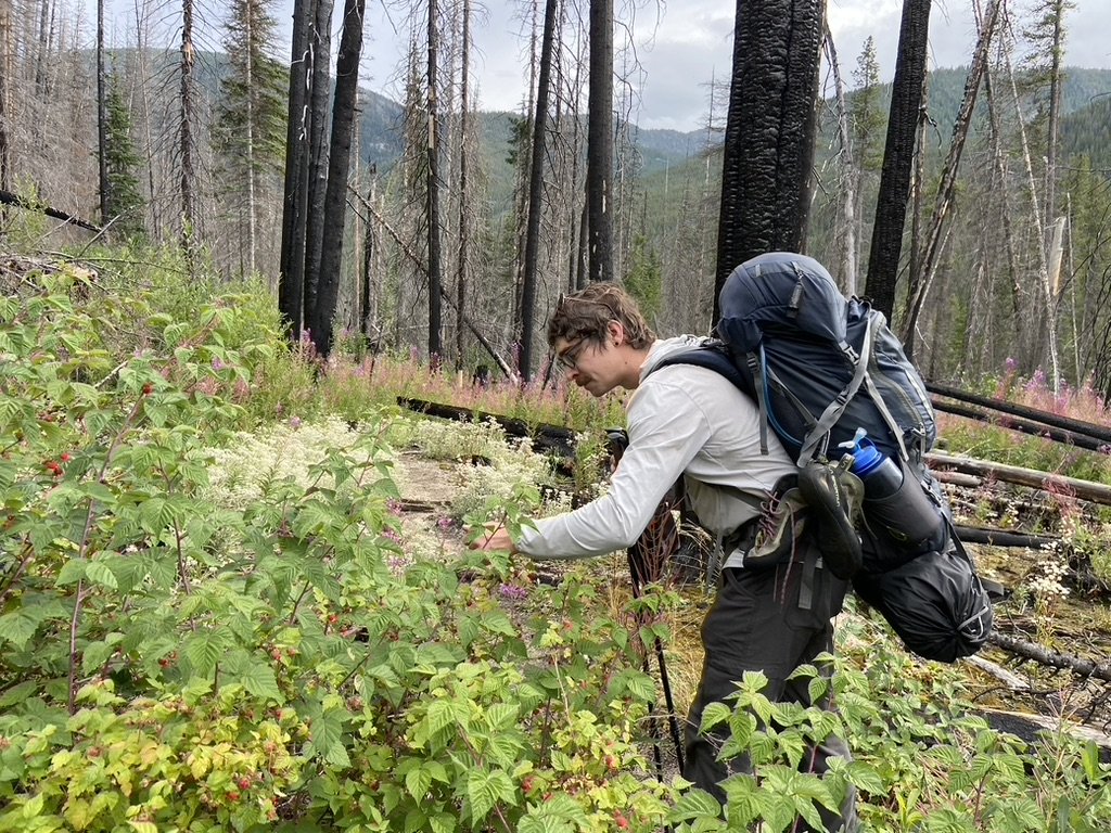
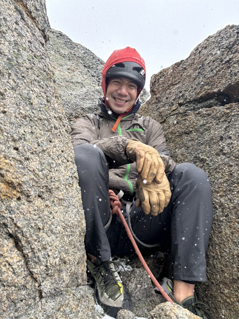
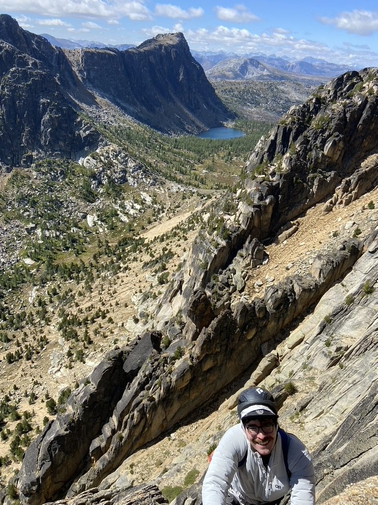
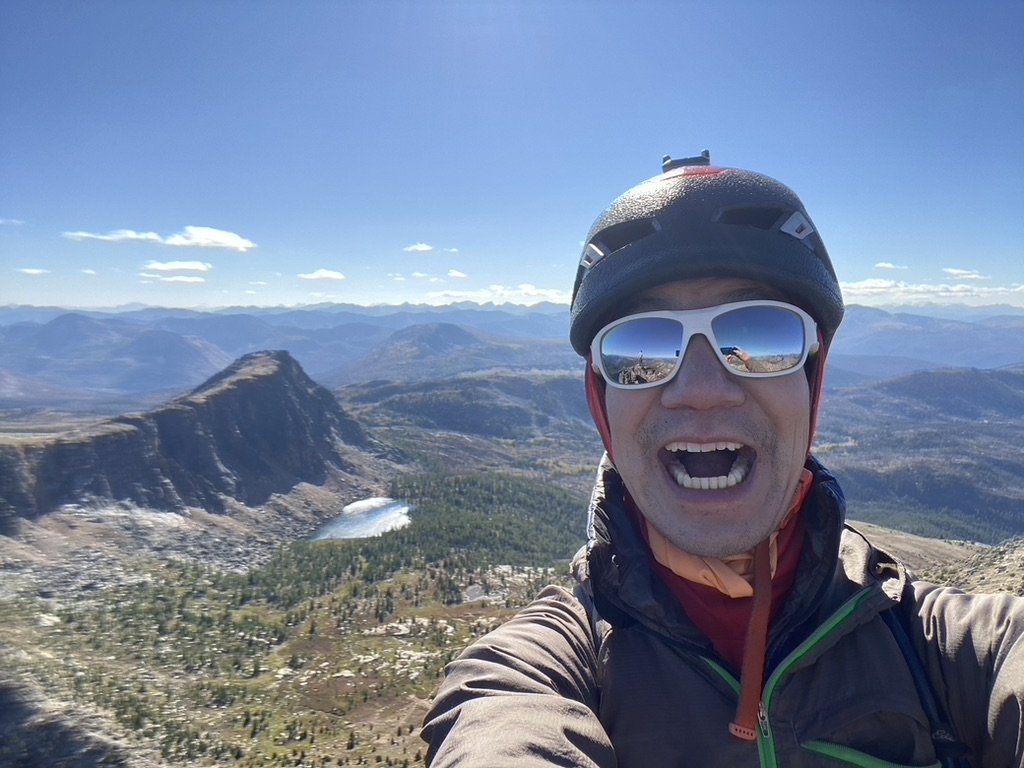
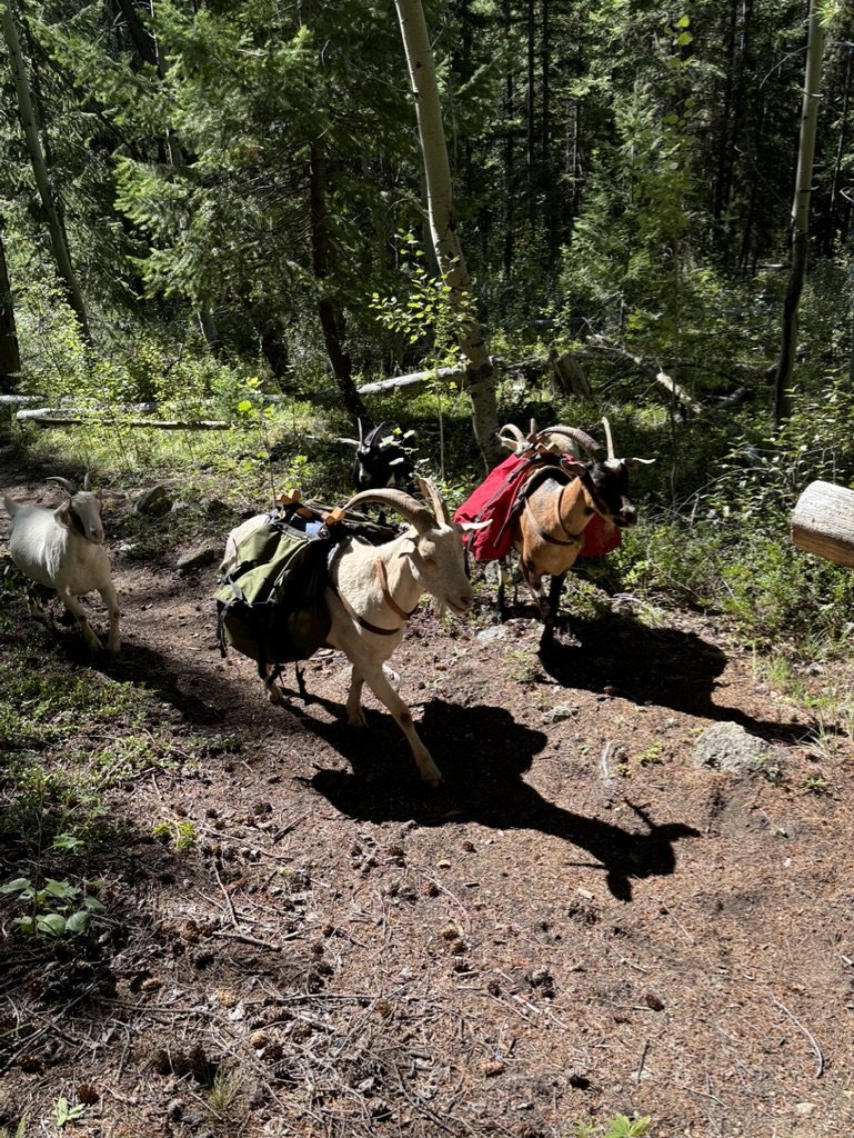
It seemed like fate. The guy seated next to me at my WFR class casually mentioned that his goal for the summer was also to climb Cathedral Peak. Ever since a failed attempt on Goode, I'd been wanting to climb something big with a long approach, and Cathedral had been at the top of the list for a while. I like the planning required for alpine climbing. Is this a backpacking trip or a climbing trip? Yes. Do I need approach shoes or would they be too heavy? Yes. Jacob and I decided on a 4 day trip. We left Seattle for Thirtymile Trailhead on Monday morning and hit the Chewuch Trail by 11:00 AM. The first 8 miles until the intersection with the Tungsten Trail are quite exposed from the various wildfires that have ripped through the gorge over the years. It's a busy horse trail, so it was in good shape with only a couple of blowdowns and very gradual, almost unnoticeable elevation gain. Also, perfectly ripe raspberries that the bears hadn't gotten to yet: We found a small campsite after 15 miles and slept soundly for the night. The next morning, we banged out the last 5 miles to Upper Cathedral Lake and thought we'd snag Pilgrimage to Mecca in the afternoon. A late summer snowstorm doused that plan. It blew in quickly right as we were roping up at the base, so at least we didn't epic and were able to get back to the tent, where we spent the rest of the day staring at the ceiling trying to stay warm. The next morning, we asked the inReach for a forecast. It said partly cloudy and high 40s with gusts up to 15 mph. At least with no more precipitation in the forecast, we decided to make a go for it and were climbing by 8:30. The forecast turned out to be exactly correct. I wasn't exactly freezing, but the wind was sucking the life blood out of my fingers and toes. When I arrived at the first belay, Jacob awarded me official Trad Dad status for wearing wool socks under my climbing shoes. By mid morning, the sun had come out and the wind had died down. In the chockstone chimney on pitch 2, I ripped off a toaster sized flake which luckily missed both Jacob and the rope. For a remote alpine route, the SE Buttress is surprisingly clean with only a few No Touchy blocks. Still, we doubled down on being careful and finished the route in good style in just under 7 hours. After we got down, we packed up camp and made it 5 miles to the horse camp near Apex Pass before resting for the night. The next morning, we finished the loop on the Tungsten Trail. The Tungsten Trail is slightly rockier and steeper in sections than the Chewuch Trail, but I think hiking in either direction would be fine. Water is plentiful along both trails, although stopping to filter water every few miles gives your body more time to express its resentment toward you. On our way out, we met some goatpackers who were training their herd to carry their stuff for them. We felt like such suckers for not thinking of this obvious life hack. This trip was an amazing experience. I liked that it required a ton of different skills to pull off successfully: trip planning, backpacking, climbing, risk management. And serendipity! Finding the right partner at the right time to achieve a shared goal.
-
When we woke up around dawn the next day, the water level didn’t seem dramatically different. Our feet were not doing well, and we had already mentally bailed, so we decided not to press our luck. On our way out, we ran into two separate parties headed toward Goode, and showed them video of the crossings. I hope they had better luck/skill!
-
Trip: Goode - NE Buttress Trip Date: 07/02/2021 Trip Report: Ever since hiking over Park Creek Pass and seeing the true glory of the park, I've wanted to return and climb Goode. Albert and I hadn't seen each other since before the pandemic, and were stoked to get out on an adventure. On Monday, things weren't looking good. Seattle recorded its hottest day ever, and the temperature at the bivy was forecast to be 100 degrees Fahrenheit. By Thursday, however, the heat dome had dissipated, and an attempt seemed feasible. Our original 3-day plan was complicated by the washout of the North Fork Bridge. Instead of descending to the Park Creek Trail and returning to the Bridge Creek Trailhead via the PCT on day 3, we'd have to hike to High Bridge, take the bus to Stehekin, and hike back 17 miles via McAlester Pass on day 4. An hour-long line at Marblemount welcomed us on Friday morning, but we were able to get a cross-country permit no problem. The ranger told us that the bridge had just been repaired, so we reverted to our original 3-day plan. We left Bridge Creek at 9:30. We reached the turnoff for the North Fork trail at 1:30, and got a visual of the new bridge from atop the cliff. We optimistically believed that we'd be able to make the bivy by sunset, summit on Saturday, and return via the bridge on Sunday. Fording Grizzly Creek presented the first challenge. The creek crossed the trail at a point where the water seemed quite swift and deep. Luckily, the creek was broken up by islands of trees about a hundred feet downstream, and we were able to pick our way across knee-deep sections. Faffing about always takes longer than it seems. It took more than an hour to cross the creek, dry off, and get going again. We reached the North Fork crossing at 5:30. We were hoping that there might be logs conveniently laid across the creek, but the creek was raging everywhere up and downstream of the crossing. There appeared to be sections where we could definitely make it halfway across, but we were unwilling to traverse rapids of unknown depth beyond that. We debated putting on our harnesses and using rope tension to "rappel" across, as suggested in Blake's guide book, but neither of us had ever tried this technique. We were losing time and were exhausted. Even if we made it across, we and all of our gear would get wet, and we'd still have to climb 2000' to the bivy. We decided to hike another 1.5 miles upstream to the crossing described by Beckey. When we got there at 7:00, we found that the snow bridges had already melted out, and the creek was equally high there. We made the decision to bail. We bivied on an island of rock in the middle of the creek, gorged ourselves on our extra food, and limped back the next day. The next time I attempt Goode, I'll not underestimate the difficulty of the hiking, and will probably take an extra day for both the approach and the descent. Despite not even reaching the base of the climb, it was still an unforgettable experience. Gear Notes: Backpacking gear for 4 days. 60m half/twin rope. 5 cams 0.4"-2", nuts. Approach shoes for scrambling, trail runners for hiking. Approach Notes: Two high, swift water crossings (Grizzly Creek and North Fork). The Bridge Creek bridge has been repaired.
-
Found a BD cam on the penultimate gully pitch of the SW Rib of SEWS. Not stuck and recently placed, probably just missed by your follower. Describe it, and I’ll do my best to get it back to you.
-
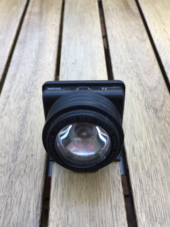
Found Petzl E03 250 headlamp with newish Duracell AA batteries on the approach to Dreamer between the creek crossing and brushy tunnel. Let me know if it’s yours, and how the hike out was in the dark.
-
Looks to have been dropped fairly recently. Describe brand and color and I'll try to get it back to you.
-
Found a spiral bound copy of Dilley's Selected Climbs of Frenchman Coulee left on the ground at Fat Man/Skinny Man Wall on Sunday 10/11. Let me know if I can return it to you.


