


andyrew
-
Posts
19 -
Joined
-
Last visited
Content Type
Profiles
Forums
Events
Posts posted by andyrew
-
-
Found a 'flip camera' (one of those guys with a USB plug built into it) on the Whitman Glacier yesterday. Anyone missing one?
-
Also try the fifth season in Mount Shasta, CA.
-
The ice is up the power plant road on CA-120 west of town. I haven't climbed it. March might be a little late? See http://www.summitpost.org/chouinard-falls-lee-vining-canyon/157618 and http://www.thebackcountry.net/bb/viewtopic.php?t=1799 . The backcountry.net forums are a good place for general sierra conditions, although tend to mainly be skiing TRs.
If you are passing through Lee Vining, you must stop at the Mo Mart (mobile gas station about 1/2 mile west on 120 from town). Possibly the best food in the Eastern Sierra. There is decent, free camping on BLM land around Mono Lake. Head towards the airport, then work your way south east on roads.
There is awesome, awesome, awesome skiing above Lee Vining canyon. Coke Chute and others coming off the Dana plateau are very accessible in the winter. Kidney and Solstice Couloirs on Mount Dana proper are bigger days. If your travels take your further south, you should also check out the skiing above the Buttermilks (Bishop area). You could spend a week skiing awesome terrain there. East face of Basin mountain, the Wahoo Gulleys on Mt Emerson, North Couloir of Mount Thompson.
Enjoy! The eastern sierra is one of my favorite places on this planet.
-
Thanks for the report, I've been wondering how conditions were up there. How did the snow look for skiing on the Ingraham? Sastrugified? Water ice? Lots of thinly-bridged maneaters?
-
I keep hearing great things about Luna, how do you get to the peak from the south (Goodell creek)?
Short answer is that you don't. Crossing Picket Pass and climbing out the headwaters of MacMillan creek up Outrigger is the crux of a Picket traverse. Take a look at http://www.mountainwerks.org/cma/2004/pickets/index.html to see exactly that that might entail, or just look at a map. Looks unlikely, because it is.
Far easier to 1) approach Luna via Big Beaver/Access Creek or 2) Whatcom Pass/Challenger Glacier/Luna cirque/Luna Col, and these are still not easy options! I did 1) this summer and found it to be the most taxing approach I've done, anywhere, and I've climbed a bit in the Sierra and Andes besides a lot of the usual suspects in the Cascades. I would recommend the #2 as a much more reasonable itinerary, and it's still a burly-ass traverse. But at least with easier bailing options. Just don't try to escape via Luna Creek.
Have you looked into the Ptarmigan traverse? Just as scenic as the Pickets and much friendlier traveling. You could easily spend 10 days back there, between the traverse and all the peaks you could bag. The car shuttle issue is much more acute, though.
So the Northern Pickets offer the best scenic views? Can I see Mt Baker, Rainier, or the Olympics from here?
The main attraction view-wise of the N pickets is the view onto the N faces of the south pickets, which are freakin' gnarly looking. But you also have view of other N cascade mastiffs--eldorado, Kangaroo Ridge, Snowfield, et al, and MacMillan creek really does look like it might have dinosaurs living in it still.
-
I ski zzeros in my barons just fine, and do not notice any weirdness about the width of the toe. Main issue was setting the toe height correctly. It helps to put the boot into ski mode, pop it into the binding, then wrench it backwards (like you were skiing in the backseat) towards the the tail of the ski. This lifts the toe of the boot higher into the toe of the binding, then adjust the toe height with the piece of paper method described below:
See http://www.tetongravity.com/forums/showthread.php?t=143730&highlight=marker+height
-
No shuttle bus, and seriously, the 10 miles between Goddell creek and the Ross lake trail should be the very least of your concerns. If you don't want to whore yourself out on the road to hitch, you can walk a mile or so to the visitor center and try shoulder tapping someone who looks friendly for a ride, or lock a bike up somewhere and ride back to your car.
The route you propose is ambitious for a first trip to the range. Technically, there are certainly harder peaks/routes in the sierra and elsewhere, but it's hard to imagine anything with a greater commitment level, and greater constant navigation/routefinding difficulties than a Picket traverse. I would look carefully at my route to see what my escape options are in case I ended up biting of more than I could chew, because there are sections that you will probably not want to have to reverse.
Anyway, good luck. It's an awesome section of mountains, sublime and utterly humbling.
-
This seems nutty, but it is very tempting to bring skate skis and see how far they'd get me up and down glacier...
-
I've skied both the Fuhrer Finger and the Emmons. I far prefer the Finger--better fall line, earlier access, no dry trail to hike, and (at least in my sample size of 2) fewer crevasse shenanigans. The best skiing on the Emmons route is on the Inter Glacier. The rest is traverse-y and mellow, interspersed with gaping crevasses.
I'd wait until spring/summer corn season, and not ski it during the first big warm up (14k freezing levels). The Finger can have just absolutely ripper corn in it if you time it right. If you wait too long it gets peppered with rocks and water ice. Mid to late May and certainly no later than late June should be just about right. The Emmons stays skiable until mid July most years.
-
I hiked the rim road Thanksgiving weekend 2008. The snow very spotty and didn't seem worth bring skis, and aside from a couple shady spots, I didn't regret that decision.
The circumnav is beautiful in winter, and definitely worth doing. There are only a few spots aside from Caldera rim down to the lake (which is indeed illegal) that would have much in the way of turns. In the spring, before the rim road opens, the better access to Mt Scott may be from the east, outside the park boundary. Amar Andalkar's website has good, detailed info about the areas of the park that have the most notable ski runs: http://skimountaineer.com/CascadeSki/CascadeSki.php?name=CraterLake
As for avy danger, there are really only two places and the recommended reroutes are published here. Of the two, the Dutton cliffs did indeed seem worthy of respect. Besides snow avalanches, there was rock and icefall on the road when we (quickly) hiked past.
I would love to go back in the spring right before the road is plowed and beast it out in a day on some nordic gear. Probably need to train a bit for that one, though...
-
I knew Luke. He was a great guy who truly loved the outdoors. His avatar here was ___________. It looks like the bandwidth quota on his pics has been exceeded--does anyone know how to fix that? It'd be great if his TRs remained readable.
-
Source lake drainage is not a good place to be if you are new to the backcountry, and I would venture, a poor place to camp in nearly any snow condition. The head of the valley has probably 270 degrees of avalanche exposure. That's why the trees all look like they've been wrecked by avis down there! Same goes for the Bagley lakes basin--you can cross below some big slopes, and you don't even have the benefit of trees to show where the avalanche chutes are.
Heather ridge to skyline lake via the road is a route that is safe in nearly every condition as long as you don't stray too far east or west. Reflection Lake or Snow Lake via the Paradise road would be pretty safe, too. Around artist point, the Blueberry cat track towards Huntoon point is a safer route, too.
-
The snow in the Andes is unbelievable unconsolidated. Even the best snow in the Andes would be considered complete sugar in the Cascades. I can't imagine rapping off a snow bollard in the Andes. Pickets work in the Andes but only in neve...
The Cordilleras Blanca and Huayhuash have some of the most stable weather of any of the great ranges. After the Andean winter (February-May), the Peruvian Andes get weeks of sun. I'm no snow scientist, but I have climbed a bit in the Cordillera Blanca, and let me tell you, when the tropical sun is beating on the snow, it sure looks like it goes through melt-freeze metamorphism in a hurry. Ever been to the Sierra Nevada in the spring? Imagine the same strength of sun, but at 10 degrees latitude rather than 35.
I can't comment on the snow flutings, though. Those do look terrifying.
-
Intersting peak name, is it a rocky member of the Leporidae family (stone rabbit), or a toking monk (stoner abbit)?
Hah, that would be a stoner abbot, I think.
-
Hi guys! It's Andrew from Camp Wino. We stayed to climbers' right of the black ice and managed to stay on the snow all the way. We climbed straight up some loose 3rd class, that led to a right-trending ramp, which sounds like the one you described--loose and a little unpleasant. The rest of the climb was really fun though! Except for the descent from the S ridge into the scree bowl above the lake. That sucked big time, in my opinion. Like 35 degree dirt over slabs. Yuck.
Thanks for the fuel! It made breakfast considerably more edible Sunday morning.
-
Does anyone think that putting up a sign in the LTW parking lot indicating situation and funds needed would be useful? If the methheads wouldn't steal the stamps, we could even maybe get a weatherproof box (like the ones that contain real estate flyers) and put a pile of stamped evelopes addressed to the WCCC. I would be willing to do the legwork on this if people think it's worthwhile.
Ton of people out there on Saturday enjoying the beautiful weather and climbing. Index is so steep, clean, burly and excellent!
-
I just did it on foot last weekend. Beautiful weather and I didn't see another person for two days. I can't imagine how different the road must be in the summer with hordes of people driving it. Variable coverage--almost enough snow in places to warrant bringing lightweight x-c gear (that would have been shredded by exposed pavement and rocks in many places no doubt). But also many long bare stretches.
There's also a Crater Lake Nordic Association with a website that has some info on alternate routes for avalanche reroutes. There are a couple of places where the road is exposed (to both avalanche as well as rock and icefall it appeared) that would warrant caution in almost any winter condition. Search turns-all-year for Crater Lake and you'll get a bunch of TR's that give you a good idea of what the spring conditions are like.
Amar's guide is spot-on as far as the good turns in the area. Mt. Scott looked like it would be a lot fun. The only thing I would add is that it'd be worth plotting the route on software that gives elevation profiles to see which direction gives you the most downhill milage. I'm not certain if the standard direction (clockwise, which is often preferred because you net a 700 ft loss by ending at park hq rather than on the rim) would actually be the fastest route on skis due to the elevation profile and several long, gradual climbs I recall making. In the spring with consolidated snow conditions and more daylight it would be a lot of fun to wail the thing out in a day, I think.
-
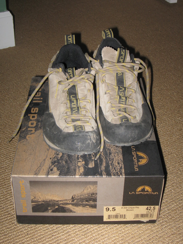
I bought these puppies about a year ago, and they are too small, which is good for climbing, but painful for walking. Only worn them 5 or 6 times.
$40$30, located in Seattle.

Howitzer Avalanche Control on Mount Snoqualmie
in Access Issues
Posted
I'm reposting this from turns-all-year since I don't see it posted here anywhere. I have no relation to Gib or the Alpental Pro patrol, so you'll have to direct questions to them.
Original thread reproduced below: