markseker
-
Posts
37 -
Joined
-
Last visited
-
Days Won
1
Content Type
Profiles
Forums
Events
Everything posted by markseker
-
fine report & photos! what was reason for not tracking back on the JPG route? The knife-edge more dicey in reverse?
-
DonnV - Nice summit and photos, thanks for the current beta! Interested in what gear and ropes were needed for your team of ? folks. If included in your TR, then nevermind. We have team of three and are thinking of two 30m x 8mm, packing one only for use on rap off summit.
-
excellent photo, thanks. Did you see any climbers on the JP Glacier route or hear of successful summiters on same?
-
Our team of Jeff first-timers is planning to climb this weekend via one of the popular routes such as Jeff pk glacier, whitewater or even the sw slope. We don't see any recent TR's here. Anyone have route condition information less than two weeks old?
-
we attempted the popular route on deception last september and found it to be almost snow free and a scary dangerous pile of scree. turned back well below summit, determining it to be a winter route.
-
does anyone know if it's possible to traverse to yocum ridge (approx 8200') from timberline without ascending to illumination saddle? i.e. going above mississippi head but below illumination rock? -m
-
I'm part of a group targeting the Cathedral Ridge route over Easter weekend, Apr 18-21. Will try for the Top Spur trailhead if we can get close by car, ascend Timberline Trail 600 to McNeil Pt, then cross to Cathedral. Expedition style, so we'll have gear for 2-3 nights out and no hurry. Descend plan is same route. Anyone have current route beta or tips to share?
-
Social and mountain climbers - I just learned from a reliable source that - for the first time in years - the Mazama Basic Climbing School still has 60-80 open slots in the class of 2003. Last year, 300 applicants tried for 250 seats; this year it's undersubscribed. this is a beginner's school, no climbing experience needed. emphasis on safe and comprehensive climb prep. I took this intensive 6-week course 5 years ago after moving to the NW, and found it to be very good for learning the basic skills, gear requirements, and fitness to climb cascade volcanoes. yes, the class includes columbia gorge training hikes, so you get in shape (think spring training for attaining beach weight) as a bonus. Expect to meet a pile of fit outdoorsy yet diverse folks both as classmates and instructors. The class begins March 31 and means committing $295, 6 consecutive Monday lectures and 6 weekend days of field sessions/training hikes. Details and application at http://www.mazamas.org/education/bcep_info.php
-
Q: How to predict or observe wind shear lines?
markseker replied to markseker's topic in Climber's Board
thanks for the reply, skiphotomatt. most helpful. -
PROBLEM: Surface wind speed affects safety and certainly comfort and can dramatically change as a function of altitude (and many other factors). It would sure be cool to be able to predict (via published forecasts) or at least observe (via direct visual clues on a clear day) where lines of changing wind shear are likely to occur. CASE IN POINT: I witnessed a dramatic and persistent wind shear yesterday on Mt Hood at 7000'. My partner and i hiked directly uphill from Timberline Lodge 6000' to 9000', turned and snoboarded back down. 4.5 hour round trip starting at 10am. after an hour of steady 20 knot easterly wind, nobody was smiling amid this spindrifty 22 degree air. skiers, lift riders and climbers all wanted a change. the climbers got it, right at slicox hut, above which was CALM DEAD AIR to at least 9000' (and much higher, it appeared). This shear line remained all day, as we shredded down thru it on our descent to the lot. On our ascent, after nearly turning around and heading down, we were glad we didn't and the payoff was a glorious single-layer clothes all-sunny day. QUESTION: Does anyone know a way to predict this? Especially, how to predict it from below, inside the windy layer. Once above it, we could see the wind affects and dissappearing clouds as we looked down. But it's UP we wanted to know most about.
-
no rappels were done. we walked unroped down the standard south side "dog" route
-
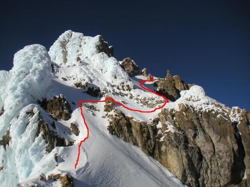
Climb Note: Mt Hood Wy'East 2003-Feb-14 Climb Date: 14-Feb-03, Valentine's day Team: Monty Smith (L), Tim Scott (AL), Francis Chockalingam, Mark Seker Notes Date: 19-Feb-03 Revision: 1.2 Notes Author: Mark Seker (primary), with edits by Tim Scott and Monty Smith Reference: URL for photos http://members19.clubphoto.com/monty672735/1148318/ Climb Summary: from the timberline lodge trailhead, our team of 4 ascended to summit on the exploratory (for us) Wy'east route, descending the dog route. Weather held out free of precipitation, cloudless above and virtually wind free over entire route. 8:55 hours to summit, 0:42 hours on summit performing various antics; 2:17 hours to return to trailhead, except for Tim, whose hi-tech glissade device saved him 25 mins on the descent. Route finding above 9770' was our primary challenge, and this final section took us more than 4 hours to complete. Winter daytime climb conditions allowed headlamp-free travel, except the final hour of descent, which was lit by moonlight (one of the two fully exposed moons the team saw this day). Conditions - Expected: Significant new snow had not fallen anywhere on the route for at least 4-5 days, weather being generally clear thru the region. New fronts were threatening, including a weak precip-producing cloud layer on climb day, but we expected a window long enough for our climb before the major change expected the day after (Saturday) this climb. Snow level dropping from 6000' to 4500' today. Conditions - Actual: Clouds in Portland and rain in Sandy on climb day were perilous, but the cloud deck was thin at Timberline trailhead, where a dusting of snow had fallen during the night. Starting weather was inside the top of a cloud layer, 29 degrees and light wind. Temperature was steady all day, seeming hot during windless sunny ascent (often in single layer clothing) although frozen water in jugs indicated air was below 30 degrees. Snow conditions were good the entire route allowing secure travel with crampons and ice ax; this means we could kick steps in consolidated but not icy snow almost the entire route. In addition, no ice screws were used, as a single picket per line could be made secure for the running belay used. Some exceptions were noted for a few rock steps above 9800', occasional holes or hollow spots, and random sun-glazed ice (mostly on the down route between crater rock and palmer lift) Above 10,000' we all used an ice tool with our ice ax, although no hard ice was encountered. Gear: We each had the Mt Hood dog route gear, but added for each: 1 picket, 1 ice tool, avy beacon, pulley/biners for crevasse rescue. Additional team gear carried: 3 biv bags, 6 ice screws, MLU, 2 cell phones, 2 cameras, 2 shovels, 3 thermal pads, and one 50M 10.5 dry rope. Gear we wished we had: 3-4 more pickets would have reduced the number of lead changes required, and saved some time. Camera tripod for summit team photo. More props for summit antics, as the summit wind did not cooperate enough to even fly the kite! No wind on summit, what a bummer. Detailed Travel Log: ============================= Time / Altitude / What was happening ============================= 07:21 alt 5995 depart timberline lot; to silcox hut (break); exited cloud layer before silcox, and remained in bright sun until sunset; angled up to right to knob on w edge of wht river valley 09:02 alt 8295 arrive at knob on wht river cross into wht river glacier valley; harnessed and roped from here to summit; order: Monty, Francis, Mark, Tim using entire 50m rope with 3-4 kiwi coils on ends. Prusiks installed to cross wht river glacier. This exit point over ridge between palmer and wht glaciers was perfect, providing an easy ramp "down" to wht river glacier and almost no elevation loss. After crossing glacier above some obvious snow-covered crevasses we chose to head up the fall line of the lateral moraine to wy'east ridge versus taking the topo line traverse. Estimate 35 degree slope at steepest point. 10:00 (alt 8500?) exit wht river glacier valley, approx 1 hour after entering. 11:59 alt 9770 top of wyeast ridge, where it hit steele cliffs rocks; place first pro below rocks; removed prusiks. Now the route-finding fun began, having to repeatedly decide to ascend up or traverse right below rock outcrops. All but a few hundred feet of the top 1500' needed picket pro, and we had to switch leads 3 times to move safely with running belay and at least one picket. Occasional hazard of balling up crampons, hidden holes (Monty went to waist once) and tricky moves around a few rocks. Route finding was helped in several places by footprints of prior team on route still visible from another day. Slope averaged 35-50 degrees, and we often were on a high-angle traverse, effectively winding around to the north to avoid the rocks above and not ascending the fall line. 13:46 alt 10360 stop using pro on "bomber snow" slope just below ridge; arrive at ridge top to see over steele cliffs into crater for first time; team gathered together for final time before summit, trading food and smiles. 14:02 alt 10555 start pro again; ref Monty's "redlined" photo to see route chosen. Lead was switched once from here to summit, so Tim topped out first. This was the coolest part of the trip. 6 pitches of snow on steep, exposed slopes. Some tough foot placement situations and a traverse on a steep section before the final turn up to the summit. Very cool. Steepest slope estimated near 60 degrees. 16:16 alt 11250 summit; no wind, CAVU conditions in all directions. Lower cloud deck below 6500' now gone. Ate lunch, emptied natural bladders, performed antics pictures; one party of 2 had taken dog route that day many hours ahead of us, otherwise we were the only climb party this day. 16:54 alt 11250 depart summit for dog route down; no rope, harness, ice tools used in descent. Crampons needed until palmer lift due to icy patches; Mark and Francis chose to alternate glissade and falling on asses on hard spots from 10,000 to 8500', which caused profanity. Watched moonrise (ref photos) over steele cliffs, as we alternated glissading and walking down. Did not encounter any other people, including skiers/boarders over entire route today. 19:11 alt 5960 arrive at car, drink beer the end //