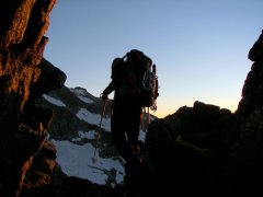
jordansahls Posted August 3, 2011 Share Posted August 3, 2011 (edited) Trip: Adams - Adams Glacier Date: 7/30/2011 Trip Report: After tasting success on Rainier via the Kautz the previous weekend, Brian and I decided to try and keep the streak rolling by knocking off yet another Volcano. Neither of us had attempted to climb Adams so the choice was easy. The route was good, but a lot more involved than I anticipated. It was a much more "interesting" climb than the Kautz. We had a combination of unconsolidated snow, ice, and neve. Also, the barren nature of the terrain and the general lack of people give the mountain a bit more of an ominous and remote feel, pretty cool. Anyway, here are pictures. Approaching the mountain: Home sweet home: Acting like fools (I have wicked air guitar skills): Climbing early in the morning (Rainier in the background): Higher on the route: Summit plateau: Brian on top posing like a gangster. What the image doesn't capture are the 40mph winds sucking the snot from our nostrils. Strolling: Route after the descent: Gear Notes: Brought all the basic glacier gear and a picket and a few screws. We could have used both the screws and the picket but we opted to leave them in our packs for the whole climb. Approach Notes: Back roads into the north side are a disaster. Ended up taking the Divide creek trail. Edited August 13, 2011 by jordansahls Quote Link to comment Share on other sites More sharing options...
Masaru Posted August 4, 2011 Share Posted August 4, 2011 Hi. Nice trip report with great pictures! I'm finally tackling Adams Glacier this weekend and would appreciate 411 on road condition to the trailhead. What made you guys decide to take Divide Creek instead of Killen Creek TH? Thanks! Quote Link to comment Share on other sites More sharing options...
jordansahls Posted August 4, 2011 Author Share Posted August 4, 2011 We found the roads to be poorly marked. We had to turn around a few times due to confusion. We drove from Seattle to Randal and took forest service road 23 to the Killen creek trailhead. What I failed to look up was the fact that there is another way to get to the Killen creek trailhead, our way was blocked by snow and would have required an additional 6 or so miles round trip. We almost gave up when we ran into a skier who informed us about the Divide creek trail, which was a short jaunt up the road. Divide creek starts a little bit higher, and is a shorter approach. However it is under snow and took a little bit of careful navigation. All in all we found it to be extremely manageable and fairly pleasant. Quote Link to comment Share on other sites More sharing options...
Masaru Posted August 4, 2011 Share Posted August 4, 2011 Thanks so much for that information. I will make sure to ask about this at the ranger station when I get into the town and try to track the mileage from there to the trailhead. Did you guys descend on North Ridge route and then pick up the camp? Quote Link to comment Share on other sites More sharing options...
jordansahls Posted August 4, 2011 Author Share Posted August 4, 2011 Yep, we came down the north ridge. The top 1/3rd is/was covered in snow so it made for easy plunge stepping. Quote Link to comment Share on other sites More sharing options...
Masaru Posted August 8, 2011 Share Posted August 8, 2011 (edited) Just came back from Adams Glacier climb I did this passed weekend. The route required some snaking around and the exit to the right side of the glacier to reach summit plateau. Was that your experience as well? Descending the North Ridge was more difficult than I thought. Managing all kinds of loose scree on mid to lower part of the ridge was absolute nightmare. I can see why climbing North Ridge is not so popular... I took road 21 and then followed the sign after driving 19 miles on 23 from Randle. Mosquitoes were vicious at the trailhead. Edited August 8, 2011 by Masaru Quote Link to comment Share on other sites More sharing options...
jordansahls Posted August 8, 2011 Author Share Posted August 8, 2011 (edited) That sounds about right. We stuck to the right side of the glacier in general. We avoided some large snaking by making a few sketchy crossings over questionable bridges spanning a few large crevasses (they may have been gone when you were up there, or at least unpassable). Seems you drove the right way to the trailhead, we did not, but I will say the divide creek trail worked out well. Congrats, It's a fun climb. As far as the North ridge, I didn't find it to be all that bad, but I have done some really aweful descents so my compass for such things may be a little "off center". Edited August 9, 2011 by jordansahls Quote Link to comment Share on other sites More sharing options...
sobo Posted August 10, 2011 Share Posted August 10, 2011 Did you find my pair of Serengeti Drivers at the camp? Quote Link to comment Share on other sites More sharing options...
jordansahls Posted August 11, 2011 Author Share Posted August 11, 2011 (edited) Sorry, no such luck. The way that volcanic mush moves they were probably swallowed. Edited August 12, 2011 by jordansahls Quote Link to comment Share on other sites More sharing options...
sobo Posted August 12, 2011 Share Posted August 12, 2011 Before leaving the trailhead, my partner realized he had forgotten his glacier glasses, so I loaned him my Drivers (the only other pair of sunglasses I had in my rig). He fashioned some ghetto side shields out of pieces of a McDonald's drink cup that was rolling around under the seats and some duct tape. After our successful summit via the North Lyman Glacier, he placed my sunlasses atop a large block of rock while we broke camp. It wasn't until we were back at my rig that he remembered he had left them there. This was about 1995 or '96, so I was just curious if you might have seen them recently... Quote Link to comment Share on other sites More sharing options...
jeremyl Posted August 16, 2011 Share Posted August 16, 2011 Any more info? (More recent info?) Might head up. Ranger said road to TH is now open. How obvious is the trail? Is there any running water at camp? Haven't been on that side before so any info is welcome! Quote Link to comment Share on other sites More sharing options...
jordansahls Posted August 16, 2011 Author Share Posted August 16, 2011 I'm not sure about more recent info but my guess is that the road is open all the way to the Divide creek trailhead, there wasn't much snow on the road, just a few banks large enough to hinder passage (also, Killen creek trailhead is also open, has been for a few weeks). As far as water is concerned you shouldn't have a problem finding potable streams. My partner and I didn't bring a stove and instead just brought a water filter and we had absolutely no problem finding many running sources of water. I'm guessing that the Divide creek trail is still mostly under snow, or at least the last 1/2. It's a straight forward hike. Bring a map and compass and you won't have any issues. Quote Link to comment Share on other sites More sharing options...
jeremyl Posted August 17, 2011 Share Posted August 17, 2011 Thanks. Will be trackin on GPS too. Ranger Stn. said Killian TR is all snow. Is Divide Cr trail a better way in? Just going off Selected Climbs which says to use Killian (and dont get lost). Good on the water. Hopefully things are still closed up & stay quiet. Its been warm. But people went up last week apparently. Would love GPS tracks. Heading up in the morning from Ptown. Quote Link to comment Share on other sites More sharing options...
jordansahls Posted August 17, 2011 Author Share Posted August 17, 2011 I have never done the Killen creek trail, so I can't comment on it. The Divide creek trail is shorter and starts slightly higher (it was something like 3 miles to the alpine, and another mile, give or take, to camp). My partner and I found it very strait forward and direct. Honestly, either trail will work fine and I doubt that the differences are major enough to really make one better than the other. Quote Link to comment Share on other sites More sharing options...
leora Posted September 21, 2011 Share Posted September 21, 2011 Sorry that I didn't get this up, earlier - I wrote up a trip report, and it vanished into Cascade Climbers' heaven before it got posted. . . My partner and I climbed it on Labor Day weekend - roads were all clear, at that time, and some of the questionable bridges over crevasses were no doubt gone. We took quite a bit of time to negotiate all of the crevasses. On the North Ridge descent, one has to know about some 3 specific places to cross over the ridge, the first from the right to the left side, the second from the left to the right side, and the third from the right to the left, when you hook up with the sidewalk-like trail for the last 1000 or so feet. If you know those places (I saw a little orange flag at the 2nd place, this time), then it tends not to be so bad. Our route up followed the green in the picture, below. We couldn't tell that we wouldn't be able to get over the one huge crevasse until we were almost on top of it. We backtracked a bit to another crevasse, where we thought that we could walk inside of it, and potentially find a way out. The blue line in the photo was that backtrack, with the dots being the place where we were inside of the crevasse. If I've pointed to the correct picture, there should also be a red line where another team (friends of ours) made an attempt, but weren't able to get over a crevasse - I'm guessing at which one it was. Their ascent was a much more icy ascent than ours. Ours started out as ice, and then became mostly snow. So, the route picture: And here is a photo of me while we were inside what did turn out to be our last crevasse, at the beginning of the blue dots: And then one more looking back after we did succeed in finding a path through the crevasse, right under that anvil-looking thing which reminds me of that tram over at OHSU. . .: Oh, and I'd like to include the following because it showed the layers of snow: I was in shock that we were doing this climb at the beginning of September, with what seemed like mid or late July conditions. The field ranger whom we ran into was worried about us because the snow on the right cliffs hadn't fallen off, yet, and it was a warm weekend. Fortunately, none fell off while we were on the route. And I loved it when he tried to assess our abilities to climb it - "have you climbed anything similar to this, before?" Indeed - this very route, which I absolutely love. . . leora Quote Link to comment Share on other sites More sharing options...


Recommended Posts
Join the conversation
You can post now and register later. If you have an account, sign in now to post with your account.