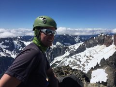
n9643750 Posted July 16, 2016 Share Posted July 16, 2016 (edited) Trip: Mount Buckner - SW Slope Date: 7/16/2016 Trip Report: Tobias and I climbed MT Buckner over three days from Sahale arm We hiked up to the Sahale glacier on Wednesday and set up camp in the late afternoon. The weather was great and we found the snow to be pretty soft when we arrived at Sahale glacier camp. We spent the remainder of the day lounging, drinking whiskey and playing name that peak The next morning we started off towards horseshoe basin around 5:45 AM. The snow had firmed up completely and we were able to move fairly quickly down moderately steep snow to around 7200 ft where we gained a rock rib coming off of Sahale peak. The rib was easy to descend and we followed it down to 6600 or so where we located a steep snow finger dropping into horseshoe basin. The snow was still quite firm and we backed down 50 feet or so before traversing into the basin. We were then able to follow snow all the way around horseshoe basin to the base of Buckner, traversing around 6600 ft. (the snow finger is at the lower left end of the ridge coming off of Sahale) When we arrived at the base of Buckner, we found the snow on the SW slope was still firm, and we were able to climb nearly 1000 ft on front points with two axes. It was quite secure and really fun, but my legs were blasted afterwards! We arrived on the summit around 12:30. It was a beautiful sunny day, but clouds were building in the west, and we felt that we should abandon our original plan to summit horseshoe peak as well and just head back to camp. Goode, Storm King, Black peak summit shot! Eldorado, Forbidden, Boston Glacier Boston, Sahale, Horseshoe A party coming up the North Face On the way back we found the snow still a bit firm for good plunge stepping. We were able to descend a rock rib skiers left of the snow field and with a short bit of traversing and down climbing snow to the right, we gained another one that eventually deposited us on snow a few hundred feet above the base of the mountain. By then the snow had softened and the slope eased enough to make plunge stepping very comfortable. We descended into the traverse and headed back across horseshoe basin. Back at the snow finger, we thought we'd take a look around the base of the rock rib, as we had heard there was a ledge route that might go. We easily located a diagonal ledgey ramp and started up. Upon reaching an alcove full of old mining equipment we broke out the rope for the first time that day to get past one very exposed fourth class move on mossy rocks with deadly exposure. This got us to a notch in the ridge from where I could see our route from earlier in the day. Getting to it required climbing up grassy and heathery benches, but nothing too bad and eventually we were scrambling rock again. The snow field at 7200 was very soft when we got there and we were able to kick big bucket steps in it. We got back to camp around 7:45 just as a cold cloud enveloped the area and reduced visibility to nothing. No speed records, but a great day in the mountains. The next day we headed down Sahale arm and out to get burgers in marblemount. Gear Notes: Brought an axe and tool apiece, and a rope and pickets for running belays. We also had three pieces of rock pro for horseshoe. Could have gone without the rope, and never got the pickets out, but we were happy to have the second tool, as it made climbing the steep hard snow more fun. Approach Notes: Snow free to Sahale Glacier camp. Edited July 16, 2016 by n9643750 Quote Link to comment Share on other sites More sharing options...
n9643750 Posted July 17, 2016 Author Share Posted July 17, 2016 can anyone tell me why the photos in this TR appear rotated when viewed on my phone? It seems like I can format them to be oriented properly to be viewed on the phone or the computer, but not both. Quote Link to comment Share on other sites More sharing options...
olyclimber Posted July 18, 2016 Share Posted July 18, 2016 it looks fixed to me now! I was looking at the TR earlier and they were f'd up then, but it is fixed now. Thanks and great TR! Already helped out one person I know with the conditions report! What is the story with the miner's booty there? Quote Link to comment Share on other sites More sharing options...
Tom_Sjolseth Posted July 18, 2016 Share Posted July 18, 2016 The Black Warrior Mine is located in upper Horseshoe Basin. You can still see the steel rails for the mine cars and some mining artifacts. Giant steel cables that used to hold the ski-lift style tram cars can be found linking the upper and lower basins. See here. Quote Link to comment Share on other sites More sharing options...
KaskadskyjKozak Posted July 18, 2016 Share Posted July 18, 2016 The Black Warrior Mine is located in upper Horseshoe Basin. You can still see the steel rails for the mine cars and some mining artifacts. Giant steel cables that used to hold the ski-lift style tram cars can be found linking the upper and lower basins. See here. I ran into the rails leading out to the cliff when I climbed Horseshoe a couple of years ago. Very cool. The entrance to the mine is buried under rocks now though. Cool link to the story, Tom! Quote Link to comment Share on other sites More sharing options...
n9643750 Posted July 18, 2016 Author Share Posted July 18, 2016 Thanks for the link Tom, That was an interesting read. We spotted some of the old rails and cables and possibly the rock-covered entrance to the old mine in the middle of the basin. The equipment in the photo above appeared to be just a gear cache of sorts, tucked into an alcove at the end of the rock rib coming off of Sahale. Quote Link to comment Share on other sites More sharing options...
n9643750 Posted July 18, 2016 Author Share Posted July 18, 2016 it looks fixed to me now! I was looking at the TR earlier and they were f'd up then, but it is fixed now. Thanks and great TR! Already helped out one person I know with the conditions report! What is the story with the miner's booty there? weird.... still looks good on the computer and messed up on my phone. Thanks for the feedback! Quote Link to comment Share on other sites More sharing options...


Recommended Posts
Join the conversation
You can post now and register later. If you have an account, sign in now to post with your account.