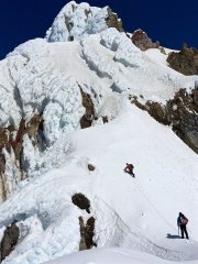
Ptown_Climber1 Posted July 4, 2016 Share Posted July 4, 2016 Trip: Mt. Hood - Sunshine Route Date: 7/3/2016 Trip Report: I got out and climbed Sunshine Route today, squeezing in one last Hood climb before summer really takes its toll on the old volcano in our backyard. Two friends and I (one in the role of driver/sherpa) set out from Cloud Cap yesterday afternoon, with the intent of finding a good bivy site at the base of snow dome....mission accomplished at 8,100 feet. It's hard to imagine a more picturesque and peaceful spot to set up camp. Thank goodness for the rock walls already in place, for the winds out of the west were a howling companion all through the night and into summit day. Waking at 3, we wrestled out of our cocoons and began to prepare for what lay ahead. After some fumbling around in the dark and a little god awful oatmeal, we geared up and set out around 4:30. The first hour or so trudging up snow dome was largely uneventful, but the views north of Adams, Rainier, and St, Helens never disappointed. The sunrise was a sight to behold....Leaning into the 30+ mph winds, we eventually arrived at the crux of our climb. Looking up at Anderson and Horseshoe Rocks the day before I was struck by the breadth of the bergshrunds beneath each. As we approached Anderson, I saw a boot path angling up the edge of a snow bridge and on up along the rocks. On this day anyways, the snow was pretty soft, but I followed the tracks. Within only a couple steps in, my ice axe and arm dropped into a chasm. Down climb time. So we then dropped below and to the left, and found a more direct line onto the rotten rocky outcropping. This was steeper than I envisioned, and onboard a cornucopia of crumbly rock, gravel and thin ice...the bergshrund's maw awaited below.....protecting it seemed impossible, so my partner and I pushed through as fast as we could, myself trying hard not to dislodge any of the multitude of rotten, sulphur stained soccer balls onto my partner's head below. After a harrowing little bit there, we pushed on towards Horseshoe Rock. In my mind the specter of a downclimb back through that on this quickly warming morning was not an option. So I really hoped that a snowbridge might emerge upon closer look, that I had not seen from below. To our good fortune, there was...although I can't say for how much longer. That thing is getting thin and saggy. We belayed each other across, but really hoped beyond hope it held, at least for two sorry ass climbers trying to squeeze in a little more adventure before the big 4th of July holiday! And fortunately it did... From there, it was a steep 50 degree stair-step towards Cathedral Ridge and its 'gale winds'...but lest we rest easy we were in for more surprises. Oh yes, I hadn't recalled there being crevasses along the side of Horseshoe, but indeed there's something lurking underneath - a moat perhaps?....anyhow,I plunged knee deep into something....the darkness below I was unwilling to look at for very long. We did top out though on Cathedral, and while the winds were fierce, we made our way up Queens Chair and to a rather adrenaline charged cross of the summit ridge. We had the top to ourselves today at approximately 9AM. A few folks were coming up Mazama Chute....one carrying an American Flag of all things, but when you climb Hood on 4th of July weekend I guess nothing is unexpected. The snow conditions on the southwest side of the mountain were much better....firm and solid, unlike the mushy stuff already presenting itself on the upper Sunshine. Rockfall and icefall were nonexistent. I really don't know that I'd recommend Sunshine anymore this season, unless you get up there on subfreezing day, because those bridges are getting awfully thin. Global warming has done a number on the Eliot Glacier in general I'd say, but that's a topic for another board I'm sure. Quote Link to comment Share on other sites More sharing options...
foxStick Posted July 7, 2016 Share Posted July 7, 2016 Nice work, when you say you think the route is almost done, were you talking about the standard route up or did you go with the later season variation like in the picture below? http://glenn.widener.us/climbs/2011/sunshine_690/route.jpg Quote Link to comment Share on other sites More sharing options...
Ptown_Climber1 Posted July 7, 2016 Author Share Posted July 7, 2016 (edited) Well, I assume you mean the right line in your pic as the later season variation? What I saw on the left line was pretty sketchy, in my opinion....if you traverse over to the right, I can't say, other than the exposure increased, and it did seem like there were more cracks to navigate getting over there. Edited July 7, 2016 by Ptown_Climber1 Quote Link to comment Share on other sites More sharing options...


Recommended Posts
Join the conversation
You can post now and register later. If you have an account, sign in now to post with your account.