Ptown_Climber1 Posted May 30, 2013 Share Posted May 30, 2013 (edited) Trip: Mt. Whitney - Mountaineers Route Date: 5/26/2013 Trip Report: Well, we finally knocked off the Mountaineers Route on Whitney –something I’d desired for years. But living in Portland, there just never seemed the right time to make it happen. It’s not exactly the easiest place to get to either. But I figured that any route that can claim its first ascendant to be none other than John Muir himself, must be worth the trouble….and it was. We flew out of Portland EARLY Friday morning to Reno, NV. My cousin Buck picked us up and headed south down the eastern edge of the Sierras. The weather was warm and dry; a nice contrast from the cool rain inundating the northwest these days. Highway 395 cuts a lonely path through a mix of high desert plateau, alfalfa fields, and even volcanic calderas, all the while stopping here and there in cities that bleed historical small town charm: Big Pine, Independence, Lee Vining, Bishop, and ultimately Lone Pine. It is there that, after hours of driving and anticipation, we stop to pick up our permits. The visitors center there is newish and impressive- the staff friendly and helpful, surely a good omen. After picking up our permits, we head up Whitney Portal Road to our destination. The parking lot is pretty full; it is Memorial Day weekend, after all. But most of these people are headed up the mule, err, main trail. After packing up our 50-60 pound packs we take a quick snapshot and are off. We share the main Whitney trail for about a mile or so before branching off at the junction with North Lone Pine Creek. The main trail turns left…we head right, and the climbing begins. The elevation gain is abrupt. The trail snakes its way through shady pine forest before peaking out into granite-cluttered hillsides, staying close to the creek, while edging closer and closer to the famed Ebersbacher Ledges. Accessing the ledges wasn’t too difficult; I’d spent way too much time studying this route on more climbing sites than I care to count. Once we hit the lone pine at the familiar spot it became pretty intuitive. Some exposure, but nothing too crazy. We did however initially start out a little low on our traverse back towards Lower Boy Scout Lake…..a friendly German day- hiker yelled at us from below, “You’re TOO low! Too low!” We adjusted and bushwhacked our way higher. This recalculating of route became a frequent routine… After a seemingly endless trudge through granite ensconced trail steps, we cross the North Fork Creek again, in a calmer state. The lake loomed before us, cradled by the upper slopes of rugged Mt. Whitney, in view for the first time. We set up camp, eat some tasty ravioli courtesy of Buck and his favorite Oakland Italian joint, and even enjoy some fresh bread and cabernet….we be living the high life here in the high Sierra! And for dessert….a few snorts of Centenario Anejo tequila…. The next morning, after coffee and mediocre egg breakfast, we begin what becomes a common routine for us….packing up camp, and moving on. Today it’s up…but how high? That is the question. We were undecided on camping either at Upper Boy Scout Lake or Iceberg (12,400 feet). Our packs were heavy, so the idea of camping lower at Upper Boy Scout was enticing. In the end though we decided that the advantages of reaching Iceberg Lake were many; primarily because of the prime position it would put us in on summit day, being a mere 2,000 feet from the summit. We slowly leave the pine trees behind, and are greeted by the sound of rushing water cascading its way down the granite domes separating the lakes. Our only problem was navigating our way to Iceberg proper. The ‘trail’ is mostly clear, until the end. The rock cairns are fewer and farther between, and before we know it, we’re climbing up 3rd class boulder walls in trying to mount ourselves on the lake’s basin. Ultimately we do it the hard way, and there in front of us, on this late Saturday afternoon is Iceberg Lake- the final outpost before the true climb begins. At Iceberg we enjoy meeting and talking with some of the other climbers around. One in particular, an Irish guy from San Francisco, is leading a small group up the East Face. As he’s pointing out his route to us, described as one of the top 10 climbs in America, I start feeling a bit humbled. If that dude is climbing THAT, then we ought to be able to handle the cute little mountaineers route, right? I am curious how his climb went; I know the next day he intended to climb Mt. Russell and the Fish Hook Arete or some other…perhaps if he is reading this, he can chime in. We awaken at the relatively late hour of 6 in the morning. Typically I like to get more of an alpine start, but we’re not in the Cascades; the rock isn’t that rotten volcanic rubble….plus the snow is going to be firm either way going up, and I sure don’t want a piece of the climb above the notch in the dark. After some tea/coffee and oatmeal, we make our way towards the mountaineers gully. I am thrilled to finally slap on some crampons and hear that familiar metallic creak of steel on firm ice and snow….the ice axe at my side, we soon find our rhythm. There’s a guided group on the mountain this day….the clients are from New York and Florida….two of them are in blue jeans, and looking miserable. For the life of me I don’t know why they are there. Not sure what the guide service was thinking on that one…dollar signs I guess. One thing I do know is that I don’t want to be below them in that narrow rock and snow gully. Eventually we top out of the gully and reach the famed ‘notch’ at 14,100 feet. Here is where they say the ‘technical climbing’ begins. I don’t know…we take a look at it and the exposure doesn’t seem too bad, and the climb looks pretty straightforward. I guess it’s all a matter of perspective. My rock-loving chums were pretty comfortable with it. I was in plastic boots more appropriate for our snow-clad volcanoes to the north, and they weren’t the best for climbing rock ledges. In the end though we all reached the summit in our own way, and were met by calm winds, blue skies, and a view that only mountaineers can know. A small throng of hikers that had come up the trail route meandered about the stone summit hut at the top….we make our way there, make some small talk, give some high fives, and take some pictures. In my mind I can’t really relax until I get back down, but I force myself to take a break, and enjoy this special place we’d worked so hard to get to. One woman looks at us and says to me, “Wow, it looks like you guys worked a lot harder to get here than we did.” Probably so, probably so, I think to myself. I look to the north and to the south….the mighty Sierras’ jagged peaks scratch at the sky for as far as one can see. It’s been three days since I stood upon Whitney’s summit, but I’m still smiling…. In climbing it I left a part of myself on that mountain, but I think we all took home some memories that will last a lifetime. Thanks, Dean, Rich, and Buck, for being great climbing partners...let's do it again soon! Edited May 30, 2013 by Ptown_Climber1 Quote Link to comment Share on other sites More sharing options...
christophbenells Posted May 30, 2013 Share Posted May 30, 2013 First off, congrats! im sure this trip will always hold a special place in your heart. a favorite place of mine. i lived in the eastern sierra for many years before coming up to the NW.i once watched the sunrise from atop keeler needle (sharp sub peak just to the south of whitney's summit) after hiking the john muir trail. your giving me some reminiscent goosebumps just looking at the pictures! it is however very sad to see all the trash that hangs around the lake down there. i guess its just a biproduct of being the highest peak in the lower 48. the east face is not really a hard rock route, 10 pitches of low 5th class and 5.7 climbing. im sure if you go back you will not use those plastic double boots again! did you see any of the acrobatic weasels that live atop the summit? they leap off the edge to what you think is going to be pure weasel death, but miraculously they always land safely on the ledges below. one of my favorite parts though is the cheeseburger stand that is directly to your right when you exit the trail! some of the best beer and burgers ever! once again happy to see this TR! it made my day! Quote Link to comment Share on other sites More sharing options...
Ptown_Climber1 Posted May 30, 2013 Author Share Posted May 30, 2013 (edited) Thanks! Yeah, those pinnacles are something to see....I was really impressed by the beauty down there. We didn't see too much trash, although my eco-conscious cousin ended up packing out someone else's blue bag....ewwww, but more power to him. Unfortunately we didn't have enough time to hang out at the Portal Store there and get one of those famed burgers and beers...had to make it back to Reno in time for flight. Enjoyed a nice cold beer in the parking lot though. No, next time different boots for sure! Edited May 30, 2013 by Ptown_Climber1 Quote Link to comment Share on other sites More sharing options...
Pete04 Posted May 31, 2013 Share Posted May 31, 2013 Congrats - looks like you picked a good weather period. If you had gone two weeks earlier there was a lot more snow, which drove me to the "mule trail" as you put it. On my day vis was bad enough that it took UTM coords to find the summit. I only knew I was there by the summit shelter and definitely couldn't tell that it was on the top of the Lower 48. Did you happen to get any pics of Mt. Russell or Mt. Hale? I might head that way in a few weekends. Quote Link to comment Share on other sites More sharing options...
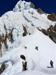
Ptown_Climber1 Posted June 1, 2013 Author Share Posted June 1, 2013 (edited) Wow....yeah that looks quite a bit different than it was for us! Can't blame ya for taking the trail route that day.... So I think this is one of the few pics we took with Mt. Russell in it...Iceberg Lake in the foreground. Edited June 1, 2013 by Ptown_Climber1 Quote Link to comment Share on other sites More sharing options...
Pete04 Posted June 5, 2013 Share Posted June 5, 2013 Great pic - thanks for the visual! Quote Link to comment Share on other sites More sharing options...


Recommended Posts
Join the conversation
You can post now and register later. If you have an account, sign in now to post with your account.