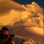
Josh Lewis Posted May 18, 2010 Share Posted May 18, 2010 Trip: This is My America! - Date: 9/26/2009 Distance: 40 Miles (24 on bike, and 16 or so on foot, a few of the walking miles were road walking) Time: 3 Days Who Came: Michael and I Elevation Gain: 8,000ish Feet This was one of my longest adventures yet! I've wanted to for a long time to bike to Sahale which is a Native American word meaning high place, which the summit is around 8,800 feet high. This is my most favorite of all mountains in the world, and especially considering that to me mountains are the most beautiful place in the world, this is what I consider paradise. This trip took place September 26, 2009 through the 28th which is three days total. The adventure consisted of about 40 miles of traveling, which we would bike from the road closure which was way down the valley, and bike up to the trailhead, and then to the pass, up Sahale Arm, and to the summit from there and back home. Two days before I had just climbed Mount Pugh which is a little over a mile in elevation gain so even before the trip I was a little tired. On September 25 my mom was going to buy us a glacier rope which would have worked out except, the Alderwood Mall REI she bought it from did not sell glacier ropes and I was not with her so she got tricked into buying a climbing rope which was instead of being 70-80$ for a glacier rope, the climbing rope was 190$! Not only that but it weighed around 4 times more than what the glacier rope would have weighed which the climbing rope was 10 pounds. This made a change in the adventure before starting. It was more than what should have been bought so we needed the money back which we had to wait the next morning for the store to open before we could return the rope. We got to the store and the lady said we need the debit card we bought it on, so we had to drive all the way back to my mom, and then back to the store and get the money back which went onto the card. After this my brother went to try to get the cash from the card and there was a transfer delay which would be atleast 48+ hours! When Michael came to me he told me "were not going, were going home!". I was worried at this point and wanted to know what was going on. Once I found out the details I came up with a plan which succeeded. I had 40$ or so in bills and change which 18$ or so was in quarters, dimes, and nickles. We then had to drive back to give my mom her card and then I called my friend Mark and spoke with him about borrowing his glacier rope which he was fine with and spoke it over with his dad which too was fine with us borrowing it as long as we took good care of it. We left for home and made 3 bean burritos for each of us, a some what filled jar of peanut butter, a small bottle of jelly, a half loaf of bread, and a little bit of other stuff which would serve as our food for the trip. My bike tire was messed up so my friends dad let me borrow his which was a bit old, but would work for the trip. If everything went according to plan, we would be back Sunday, but the rope deal complicated the trip and later ended up extending it. We drove to Mark's house and got the rope and he inspecked our gear and such which from here we set off for Cascade Valley. By the time we got to Cascade Valley the sun was already setting behind the ridge which I was hoping before that we would be there 24 hours ago which meant we would have to ride bikes fast. The start of the trip was tiring, the up hill got a bit steep, although perhaps if I had been using a better bike and if we did not have heavy packs it would not of been as bad, although we still had lots of distance anyways. The rangers said that the road would be closed at mile marker 12 but acually it was closed at mile marker 11 which added 2 extra miles which were a little extra than what we had in mind. Around mile marker 12 was where the construction was taking place, the bridge was fine, but they were doing extra repairs so that mabe it would last the winter, commonly bridges washout in winter time here. After this we had a ways of down hill which was nice. As we went down another hill I looked up and Johanesburg Mountain looming above with clouds over it which looked very big. Then we would bike up as much of a hill as we could, then walk our bikes. And it would sorta be a repeated cycle. We did not see another person until nearly making it back to the car which for days we would see no one. I was a little worried about the thought as we kept going further and further into the mountains, but at the same time it was a comforting feeling to not have to deal with loud noises, and to have quietness. There did pose danger though, if one of us got hurt or injured while hiking or biking it could be bad, we were many miles away from the car, and far from any other person and a long time before anyone would start searching for us which even then they too would have to go a long ways through the valley to find us. So we had to keep an extra caution, and not do anything reckless nor ride our bikes to fast. As we biked through the woods the sun started to set and it started to get darker and darker which we could see mountains through the trees glowing bright red which at a few spots got a clearing of. One of the mountains I remember was sticking out bright, My Beautiful Sahale! It was quite an amazing feeling being out in these woods in the Cascade Valley. Eventually as we went on we got to mile marker 21 which we knew that the remaining road from here was steep so we stashed our hikes off to the side behind a log near an old abandoned cabin. From here we walked up the road which we knew our only head lamp was low on power so we decided to save it for Cascade Pass. Using slight moon light, star light, and feeling when going up the road we got to a creek which we purified our water with my mom's water purifier. After this we hiked the last mile to the Cascade Pass trailhead. Before we got there I was looking up and watching as clouds would rise over Cascade Peak and the Triplets with a little moon light making the clouds light up which gave a really nice atmosphere to the place. The stars also made for a great show, I felt like a pioneer the way that it looked, just me, my brother, and the mountains. Later we finally get to the trailhead and turn on our only head lamp. I was in the back so that Michael could use the light to shine the way which I would watch ahead so I could know whats ahead, where I was standing there was hardly any light which sometimes I stumbled but not often. Even though normally this would be an easy hike to the pass but the bike ride, climbing Mount Pugh, and the heavy pack took its toll on us which even though my legs felt strong I felt quite tired and it later felt somewhat relentless switch backing through the woods which finally we got to Cascade Pass. From here we set up Camp and I went to sleep fast, which was very solid that night and woke up a little after sunrise. We had breakfast which was waffles and syrup and we headed up Sahale Arm. Even though it was nice and sunny, it was colder than I expected, not in temperature, but the winds kept blowing which made me have to wear a jacket going up. On the way up we found a small pond which was a good spot to purify water although a bit green and cold, but it was good enough. After this we further headed up the Arm until we got to Sahale Glacier. This is where things slowed down. Michael had a hard time putting on his crampons which he would try to mount them with shoe string which did not work so he used the straps which took a while to put together which I spent time trying to figure out why to use the figure eight on a bite which I realized because you have to shorten the rope by coiling it and having it around your neck, then you have to tie a figure eight on a bite so that non of the tension is on the coiled rope. After spending a while getting ready to cross the Sahale Glacier we started to head up. At first we were making good time up, but it soon got steep and my brothers crampon fell off! This worried both of us a bit, although I guess he was more worried about it than me, I offered for him to use my crampons and I go crampon less but he refused and kept having to readjust the crampon. Later when it was not as sloped it wasn't as much of a problem. We had to cross back and forth between the glacier because there were some crevasses that blocked a long portion of the standard route which there were no boot prints because with the whole road closure almost no one went up here. It was a very cool feeling, leading my brother up the mountain almost feeling like a guide. After going back and forth around crevasses and crossing snow bridges we were nearing the summit. At one point the crevasses crossed each other which worried me, but to our luck we found a snow bridge that worked well. And who says Sahale is not much of a glacier, in late season it very much is one with wide open crevasses. We unroped and headed up the South West Ridge, it started out as a scramble through rocks. The rocks were loose as we went up, a deal of choss. As we were scrambling on the ridge I got to a point were I did not feel comfortable and decided I would have to turn around and find another way. When I got down Michael said he was done, so the last part I had to solo. Even starting out was worry some for me, I had to be careful and hold on tight to the rock which was solid. As I pushed myself further and further up the face I was some how almost in some kind of trance, perhaps summit fever and kept going further up the rock. It got to the point were it felt like class 4, crazy emotions started striking me. One of the quotes someone once told me was "Go ahead, get yourself killed" - (Someone from Nwhikers) for some reason it kept filling my mind, the moment got more and more intense with each step until I got on the summit ridge about 100 feet from the summit. It was one of the scariest spots I have ever touched, I only took one photo from this spot and carefully put my camera away. Normally I would not have even taken the one photograph but I some how felt compelled to do so, the moment was so beautiful and view was unique. I looked up at the summit which looked atleast class 5, way to dangerous to approach, not only did the ridge look loose, but a huge cliff and glacier were below me, and I decided to call it quits here. Boston Peak looked even more intimidating, I did not stay on this spot long because of the dangers, after the trip I found out I was on the wrong ridge. Down climbing it was frightening, careful which each step worrying about a fall. Finally when I got to the class 3 part I felt a lot better. As I was heading down a safer route I looked back at the summit block at what could of been the right way to the summit which I believe goes a little around the east part. I decided against it because not only did it look a little iffy, I was solo, the sun was going to set soon, and my brothers crampons were falling off which would not be good if the glacier froze over. Even though we spent such a hard time trying to summit, I decided it was not worth the risks and that Sahale will be there some day, and besides a return trip when snow covered would be better! I return to Michael, we rope back up and try to get down as fast as possible to avoid the glacier freezing over. Heading down was not too bad, the place was starting to get sunset colors, and soon we were off the glacier, and the only time the rope was stepped on was the last step which was a tiny little mark. We repacked our gear and made a hurry down, it began to get cold quick, especially with the winds. On the way down we came back to our pond which I believe was partly frozen by this point, to filter more water. Filtering the water was extremely cold, my hands started to go numb in the proccess. We soon had to break out our head lamps, but fortunately the moon was out to help provide some light on the decent. Later we finally got back to Cascade Pass to sleep in our tent. After eating and such we went to bed, but as we were about to go to sleep the wind picked up and we started seeing lighting up parts of the tent which frightened me at first because I had no idea what was going on. To our amazement the wind was creating static electricity which glows in the dark, but I was soo tired that I soon fell asleep. When I woke up the sun was up which meant it was time to go and pack up our gear. We originally did not expect to stay a second night but considered it possible, so our food supply was short. I drank out of the jelly jar and had strait up peanut butter. Heading down was not as terrible as I had expected it to be, for the most part it was easy, although I had become quite thirsty by now due to the lack of water we had left. fortunately a ways down the road we hit the creek again and filtered some more water. By this point we were running down the road, although eventually I had to stop because it became a bit much running down the steep road with heavy packs and being tired on a hot day. Atleast the conditions were nice. We soon got to our bikes near the cabin and started heading down. After a few miles we got to the down hill section which worried me due to the slope and turns, Michael was way ahead of me, and I did not slow down much because I did not want to fall behind. Later when we got to the bottom of the hill we took a break, Michael noticed the strange noise coming from the bike (this was the same bike I used on my Steven's Pass Attempt Trip which tends to get a lot of friction). Michael "fixed it" or atleast for a little while, until the clicking came back, we swapped bikes which was so much easier on me when going up hill. "And I thought going up hill on my bike was bad enough" Michael told me when we got to the top of the hill. We swapped back, for good reasoning to. I took one last look at Johanesburg before riding down the other side of the hill. I would have taken more photos but I already deleted enough photos as it was because I was using a memory card which had 128 megabytes of space which I was disappointed about. After biking, and sometimes hiking up hill we later got to the construction zone which I was glad to see them at work on the road. After this we biked down hill and then were at the car. From here we drove home. I had to miss Monday of school which we had not expected to miss but ended up having to. This was an exciting adventure which I been so long wanting to return here, I hope to go up to the summit some day. After all, This is my America! Quote Link to comment Share on other sites More sharing options...
Dirtyleaf Posted May 18, 2010 Share Posted May 18, 2010 God Bless America. Alpine slay-master. Quote Link to comment Share on other sites More sharing options...
benmurphy Posted May 18, 2010 Share Posted May 18, 2010 Looks like a fine adventure, nice job. The cat looks real nice too...keep it up. Quote Link to comment Share on other sites More sharing options...
cbcbd Posted May 18, 2010 Share Posted May 18, 2010 Josh, this is just amazing and awesome. Keep it up, man. Quote Link to comment Share on other sites More sharing options...
JoshK Posted May 18, 2010 Share Posted May 18, 2010 (edited) Great read, Josh! Early in my climbing days I had to turn around right at the top of Sahale like you did. I'm sure it was tough, but you made the right decision. I have since climbed it several times, so as you say, it'll still be there, and I'm sure you'll be standing on top of it before too long. Keep it up, man! P.S. Where did you see the cat? He sure looks fat and happy. Edited May 18, 2010 by JoshK Quote Link to comment Share on other sites More sharing options...
rob Posted May 18, 2010 Share Posted May 18, 2010 Cool! I admire your love of the mountains. Keep it up, you'll just get stronger and stronger. Quote Link to comment Share on other sites More sharing options...
Bigtree Posted May 18, 2010 Share Posted May 18, 2010 Nice going Josh. Good TR. BTW, that cat looks fat enough to eat to me. Quote Link to comment Share on other sites More sharing options...
Josh Lewis Posted May 19, 2010 Author Share Posted May 19, 2010 Looks like a fine adventure, nice job. The cat looks real nice too...keep it up. Thanks! It was indeed! As for the cat, her name is Kitty. Josh, this is just amazing and awesome. Keep it up, man. I Appreciate it! I posted this trip report on nwhikers and pretty much got the opposite response. Great read, Josh! Early in my climbing days I had to turn around right at the top of Sahale like you did. I'm sure it was tough, but you made the right decision. I have since climbed it several times, so as you say, it'll still be there, and I'm sure you'll be standing on top of it before too long. Keep it up, man! P.S. Where did you see the cat? He sure looks fat and happy. It was a tough but outragously fun adventure! I can't wait to return, next chance I get to go there, I want to climb it, and if anyone wants to join me, let me know. The cat photo was taken in my drive way as the car was pulling out, the cats name is Kitty which is a she, I had to zoom in to take the photo, although I will admit she could loose a little weight, but atleast she's a happy kitty. Cool! I admire your love of the mountains. Keep it up, you'll just get stronger and stronger. Indeed! This year things have been going better with my trips and how often I am able to get out. Perhaps I could start putting more of the reports here? Quote Link to comment Share on other sites More sharing options...
summitchaserCJB Posted May 19, 2010 Share Posted May 19, 2010 "Perhaps I could start putting more of the reports here?" Quote Link to comment Share on other sites More sharing options...
Josh Lewis Posted May 19, 2010 Author Share Posted May 19, 2010 Got another trip report posted. Quote Link to comment Share on other sites More sharing options...
summitchaserCJB Posted May 19, 2010 Share Posted May 19, 2010 Looks epic. I actually road biked from Lake Wenatchee to Monroe in about 4.5 hours last summer. That road can be pretty scary on a bike. I can't imagine what it is like in the dark. Quote Link to comment Share on other sites More sharing options...
Lord_Albert_Winchester Posted May 19, 2010 Share Posted May 19, 2010 Well played young man. A prudent retreat in the face of overwhelming difficulties is the mark of a sensible climber. Quote Link to comment Share on other sites More sharing options...
Josh Lewis Posted May 20, 2010 Author Share Posted May 20, 2010 Well played young man. A prudent retreat in the face of overwhelming difficulties is the mark of a sensible climber. Thanks, believe me I hated to have to turn around on my favorite mountains after spending days trying to get up it, just being 100 feet away, so close almost like I could touch it. I did not try the alternative way because time was running out and I was solo by this point because my brother did not feel comfortable on the slope. Quote Link to comment Share on other sites More sharing options...


Recommended Posts
Join the conversation
You can post now and register later. If you have an account, sign in now to post with your account.