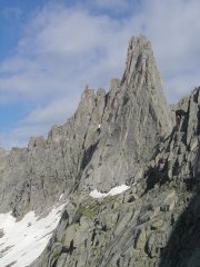
alpenho Posted July 30, 2008 Share Posted July 30, 2008 (edited) Trip: Wind River Range, WY - Cirque of the Towers - multiple Date: 7/21/2008 Trip Report: Flew to Denver on 7/20 to meet Kevin after his sister's wedding. Drove to Big Sandy Trailhead on 7/21 and started hiking by 7pm, hiked until dark about halfway to B.S. Lake. On 7/22 we hiked into the Cirque via "climber's pass" avoiding unneccesary elevation gain going over Jackass Pass. View from the pass was incredible (highlighting our climbs): Trail was good and any minimal snow was melting very fast. The Cirque still had enough snowbanks to provide handy food refrigeration, but by day 6 they had melted over 75%. This meant soggy ground and lots of mosquitos to provide motivation to get out of camp and climb. After setting up camp we made an exploratory venture about the Cirque, making our way over to Texas Pass and up Camel's Hump via the W. Ridge which was fun class 3/4 scramble to the summit. Next day made our way to Pingora via the south shoulder to access the South Buttress route: This was a fun route that went pretty fast: Next day, we went for the East Ridge of Wolf's Head, making our way up to the approach ledges and onto the saddle of the ridge: The approach was a little sketchy this early in the season since there was a large snowbank sitting at the top just pissing water onto the ledges - we ended up belaying 2 pitches on this part of the approach. Once we got up onto the ridge the rock was dry and it seemed pretty straightforward - the following picture shows the first part of the route up "the sidewalk". The party ahead of us opted for one of the cracks parallel to the crest, the lead climber is circled here where he's doing a massive arm-jam in about an 8" crack: we made our way along the traverse with some great info from a previous post by sabegg here Unfortunately, we got a little bit off on our pitches and our slow pace didn't get us to the summit until just as the sun was going down. The view was great while the light lasted but as we were setting up our rappel darkness descended. We made two raps to a ample bench where the route seemed to be somewhat indeterminant so we decided to make a very cold unplanned bivy until we had enough light to see what we were doing. At first light we located a rap station that dropped straight down into one of the south-facing gullies. This is one of the more direct descent routes but is considered more dangerous due to the loose rock and huge moats at the bottom at a snow finger. We were double-roping and did have a couple of hang-ups when pulling the knot down but fortunately avoided any rockfall. After getting down we staggered into camp at about 8am and took a rest day. This photo shows Wolf's Head from Overhanging tower, with our traverse, descent and bivy. A safer option with possibly more routefinding difficulty would be to descend to Overhanging Tower Col: After our rest day we decided to go for Overhanging Tower and Shark's Nose. We made our way up through the Cirque to O.H. Tower Col and around to the west face for a class 4+ scramble to the top. We hung out at the top for a while then made our way to the notch between OHT and Shark's Nose. We started making our way up the route for the Northwest Buttress, following the ramp and ledge system as described in Kelsey's book. There was a party immediately ahead of us that topped out on the lower ramp system and then bailed because they determined we were off-route. After considering their call and the impending thunderstorm we decided to bail. Upon inspecting the route and dissecting Kelsey's somewhat convoluted route description we determined that we were probably on the correct route but missed a hard-right traverse somewhere near the top of the lower ledge. This photo shows our route with our highest point reached by the red line: On our deproach to camp we came across some massive avy debris on a snow slope we crossed earlier in the day: We made it back to camp to enjoy our last evening in the Cirque with a great light show courtesy of the daily thunderstorm: Next morning we hiked out and drove to Missoula for some hang-out time with my family and the local brewery tour before returning to Seattle. It was an amazing trip in a place I've been obsessed about for a long time, and I'm definitely returning! http://www.youtube.com/watch?v=nyofgUZZv-U Gear Notes: mosquito repellent full-range of stoppers, but mostly used large (9+), #2 cams were very useful. 2 ropes for WH descent. Approach Notes: good beer and food at Bitter Creek Brewery in downtown Rock Springs, WY. Edited August 10, 2008 by alpenho Quote Link to comment Share on other sites More sharing options...
denalidave Posted July 30, 2008 Share Posted July 30, 2008 Wow, I too have been obsessed with the Winds and hope to get back there someday. It has been waaaay to long. Thanks for the great pics & TR. Quote Link to comment Share on other sites More sharing options...
cbcbd Posted July 30, 2008 Share Posted July 30, 2008 Awesome report and pics... looks gorgeous out there. Quote Link to comment Share on other sites More sharing options...
Lisa_D Posted July 30, 2008 Share Posted July 30, 2008 Great place. When Steph and I climbed Wolf's Head, we got a little more than we bargained for too! Our guidebook said "this route requires a sense of whimsey" and didn't tell us much more than that. When I was following, some of the traverse pitches were a bit scary for me. Quote Link to comment Share on other sites More sharing options...
grenalds Posted July 30, 2008 Share Posted July 30, 2008 Jealous, stuck at work. Great work. Pingora is on the ticklist for this summer... Quote Link to comment Share on other sites More sharing options...
nkane Posted July 30, 2008 Share Posted July 30, 2008 Great job! We probably passed you guys on your hike in, our hike out. Looks like you had better weather than us! Quote Link to comment Share on other sites More sharing options...
Stefan Posted July 30, 2008 Share Posted July 30, 2008 me jealous. thanks for sharing your wonderful pictures! Quote Link to comment Share on other sites More sharing options...
MtnLioness Posted August 10, 2008 Share Posted August 10, 2008 Looks like it was totally amazing - as always I live vicariously through you... Quote Link to comment Share on other sites More sharing options...
wfinley Posted August 11, 2008 Share Posted August 11, 2008 Awesome! Your trip was exactly like ours! We did the exact same routes last week -- and even did 2 pitches of Sharks Nose before bailing due to rain! We avoided the Wolf's Head bivy though... I don't envy your night spent up there. Quote Link to comment Share on other sites More sharing options...


Recommended Posts
Join the conversation
You can post now and register later. If you have an account, sign in now to post with your account.