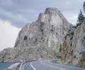
spotly Posted June 22, 2008 Share Posted June 22, 2008 Trip: Lions Head Attempt - Date: 6/16/2008 Trip Report: The road to the "easier" approach to the Lions Head is passable. One deadfall to drive around and a steep-sided stream running across in one spot. It's a rough road either way so passenger cars would get banged up even if they made it over the deep trench. Lloyd picked me up at 7:30 and we were on the trail by 10:30. The Summit Post directions to the "easier approach" are spot on but there was one intersection close to the TH that wasn't mentioned - staying right is obvious there since the granite is clearly visible in that direction. Equipped with two cans of bear spray, off we went. The new North Idaho guide book says to follow the old road next to the creek for a mile before taking a trail to the left. Summit Post says to follow the road/trail to the end where it dumps you onto the talus.Things change I guess so....we followed the road/trail for about a quarter mile where it petered out at an overgrown turn-around. From there, an obvious and surprisingly maintained trail heads up the hill to the left. I say maintained only because recent deadfalls had been recently cut from the trail. The trail itself is pretty steep and isn't very well worn so it's easy to lose - more like a moose trail. Anyhoo, we trudged up that beast to 5200' where we ran into deep compact snow. The direction was obvious at this point though - keep heading up, crossing a creek or so along the way. Lloyd laid in a few way points along the way and even without the snow, I can see how this would be very useful on the return to keep from some major bushwhacking - we used them. We hit the talus near the NW side of the cirque, just below West Lions Head. That thing was so much bigger than expected, and steep, at least of the north face. At this point we scoped out the possibilities for gaining the saddle between the West and East summits. It appeared that a steep climb up snow directly south would put us onto a wet but what looked like an eassyish scramble of maybe 50 feet or so. The other option was to follow the guide book directions and circle to the right and climb to the saddle from the south side. We decided to take the direct route and headed up the slope. We stopped at one point to put on crampons and discuss the deep snow on the slabs above the scramble - as I was saying how they didn't look too fun to climb under, a huge section slid off, slamming into the basin and sending big blocks of ice to our left. We stared for a few minutes then quickened our pace through the debris towards "plan C' - a snow finger to the NE Ridge of the East Summit. I need to get some stair stepping in because I was sucking air pretty hard getting through that section. The snow finger was steep (about 50 degrees) but other than a short section above a cliff band, the runout was a long fun slide into the basin. Once we reached the ridge we weaved through the rocks and found a ledge on the east side, which we followed for a few hundred feet till it dead-ended. There were a few spicey moves but mostly an easy scramble. We had a break and assessed the options. We could climb down to the snow and continue circling around to the south side of the saddle or find a route straight up. Since the slabs on the south side were likely to be holding snow and wetness, we started scrambling upwards. It was mostly wet 3rd and 4th class. We got to one loose section with a 10' vertical corner and stalled. The moves looked easy but getting to the corner involved a few feet on a dirty, slanting and very exposed slab with little in the way of hand holds. We decided to retreat...then to try it....then to retreat..then Lloyd made the move onto the slab and his foot slid out from under him. We both laughed then headed back to the ledge, just shy of the summit. The trip out was more direct. We followed the ridge to the NE, finding a way down to the snow on the east side of the cirque. After much plunge stepping and a "crevasse rescue" we found the first waypoint and were back at the TH by 4:15. We should have brought a short just-in-case rope and some webbing. Oh well, a good excuse to get up there again. Cool area with much bigger rock than expected. Pictures don't do it justice. Nearing West Lions Head Creek West Lions Head Climbing to the saddle Change of plan Heading towards NE ridge of East Lions Head East Face of East Lions Head East and West Lions Head from NE ridge Lloyd requires rescue Our Route Quote Link to comment Share on other sites More sharing options...


Recommended Posts
Join the conversation
You can post now and register later. If you have an account, sign in now to post with your account.