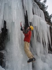
cheamclimber Posted December 2, 2007 Share Posted December 2, 2007 (edited) Trip: Sumallo Bluffs - Unnamed WI3 - 60m Date: 12/1/2007 Trip Report: I went up to the Sumallo Bluffs today with Matt Kidd and his buddy Cam. We climbed a WI3 a few hundred meters to the left of 'the mess'. The ice was super thin and sketchy for Matt to lead because of lmited screw placements. We all made it up and I was ecstatic after my first ice climb ever. Here's some pics... Here's details about our climb. We drove past the Buzowski Kippan and Landmark gullies for at most 1km and pulled over at a small parking lot across from a couple small clearcuts. We headed into the trees about 50ft back from where we parked and crossed the creek on a small log bridge we contructed over a shallow area. We bushwacked up the trees for 20 mins to find ourselves at the base of a small gully with some low angled ice at the bottom, we then traversed east into the next gully and ascended snow covered rocks to the base of our climb. The 60m rope was about 15ft short of making it to the anchor tree (above and left of the route)..so a 70m rope would be a good idea unless you want to simul climb 15ft of the route while your partner climbs to the anchor. To descend we did one single rope rappel down a cut in the trees to the left of the climb and then one double rope rappel down the last bit of trees. These two rappels bring you to a little slope 25m left of the base of the route. We then bushwacked straight down through the forest back to the car. If this is an FA I dont really know what to name the route..suggestions would be cool.. I was thinking of calling it Stairway to Heaven because the route reminded me of three big steps.. but I'm pretty sure that that name has been used a million times before. Edited December 7, 2007 by cheamclimber Quote Link to comment Share on other sites More sharing options...
cheamclimber Posted December 2, 2007 Author Share Posted December 2, 2007 (edited) post deleted Edited December 2, 2007 by cheamclimber Quote Link to comment Share on other sites More sharing options...
TrogdortheBurninator Posted December 2, 2007 Share Posted December 2, 2007 looks cool. you need to link the actual .jpg image. you can get it be right clicking on the image and getting its properties Quote Link to comment Share on other sites More sharing options...
cheamclimber Posted December 2, 2007 Author Share Posted December 2, 2007 ^thanks^ Quote Link to comment Share on other sites More sharing options...
KingsMM Posted December 2, 2007 Share Posted December 2, 2007 Where are the Sumallo Bluffs at? Quote Link to comment Share on other sites More sharing options...
cheamclimber Posted December 2, 2007 Author Share Posted December 2, 2007 24 km past Hope on Highway 3. You have to cross the Sumallo River on logs and shallow sand bard and then bushwack up to the climbs. Takes about 45 mins from car to climb. Quote Link to comment Share on other sites More sharing options...
G-spotter Posted December 2, 2007 Share Posted December 2, 2007 How far past the ruined cabins? Might be an FA. Quote Link to comment Share on other sites More sharing options...
cheamclimber Posted December 3, 2007 Author Share Posted December 3, 2007 It was a fair bit East of the cabins where there is a big pullout on the road and a clump of trees on the north side of the river. It would be cool if my first ice route was an FA Quote Link to comment Share on other sites More sharing options...
G-spotter Posted December 3, 2007 Share Posted December 3, 2007 How far west from the Sumallo Grove parking lot, then? Quote Link to comment Share on other sites More sharing options...
cheamclimber Posted December 3, 2007 Author Share Posted December 3, 2007 (edited) I thinks we pulled over at the Sumallo grove Parking lot... a big pullout on the right about a 1 or more kilometers after you pass the Bukowski/Kippan and landmark routes. Heres a really dark pic of the route from where we parked Edited December 3, 2007 by cheamclimber Quote Link to comment Share on other sites More sharing options...
G-spotter Posted December 4, 2007 Share Posted December 4, 2007 I am trying to figure out where this is in relation to Anthrax Ripple. At first I thought it might be the bottom of the larger gully just right of A.R. which is used as descent from that route but comparing your photo to my overview photo of AR and the descent gully makes the descent gully look wider than the gully in your photo. Maybe your route was further right. Was there any ice higher up in the gully than the 60m that you climbed? Don - if you read this, add your opinion. I know there are a bunch of gullies between the Mess Left and AR that sometimes have ice and sometimes don't. Quote Link to comment Share on other sites More sharing options...
cheamclimber Posted December 5, 2007 Author Share Posted December 5, 2007 there were ice steps continuing up the gully but nothing climbable, If it was thicker we could have continued up the ice steps though. The gully was facing NW (i think) and was pretty shadowed. It was pretty easy to see from where we parked but not the other areas. If its an FA or FRA I could start thinking of a name but it was WI3 and would be really good in fatter conditions. Quote Link to comment Share on other sites More sharing options...
cheamclimber Posted December 7, 2007 Author Share Posted December 7, 2007 Here's my name ideas if it's an FA.. 'Hey come on out' 'Dinner with the Devil' 'Stairway to heaven' (guessing this has beed used) 'leapfrog' Tell me what you guys think... Quote Link to comment Share on other sites More sharing options...
Don_Serl Posted December 10, 2007 Share Posted December 10, 2007 well, i needed to be in town yesterday (saturday), so I missed my chance to join Drew, Graham, and Jesse on Brice - damn! so i decided to go take a drive to check out conditions today, and poked around the Hope area wasting time and gas. drove up to Sumallo Bluffs to confirm what's what too, and I think I've got the position of this route nailed (as confirmed by email with cheamclimber). the pullout for the B-K is at the 24km marker. it's about 500m further east to the vicinity of the Mess, then about another 500m to the 'BIG' snowgully that leads from the old cabins up to a red rock headwall. (this gully is bouldery, not very steep, and never carries any ice.) a further 500m east (i.e. 1.5km past the B-K), there are two gullies above a scree cone: the right gully is pretty much dry, and the left one (which angles up and left) is where this route lies. there is a parking area just beyond some trees (as described) beside the hwy pretty much right below the route (altho across the river, of course). there's a "carry chains" sign at the parking area, with a solar panel power unit on a pole. unmistakeable. the Sumallo Grove pulloff is 1km further east again, 0.3km east of the 26km marker. cheers, Quote Link to comment Share on other sites More sharing options...
Matt Kidd Posted December 10, 2007 Share Posted December 10, 2007 (edited) This is for sure the route. Pretty obvious from the road, surprised it is unclimbed? It was thin, but if fatter would be an easy grade 3 ~50-55m. A second 20m step that could be 3+ or 4 was not completely formed, and above... ? Edited December 10, 2007 by Matt Kidd Quote Link to comment Share on other sites More sharing options...
Don_Serl Posted December 10, 2007 Share Posted December 10, 2007 hey Matt, good going for all u guys. it may have remained unclimbed so long because it may snow-up later in the winter - u guys just happened along early enuf when it was 'free', and on a quite unique time when it was iced up early. I've stared up at various ice formations along this stretch quite a few times, and i don't recall having ever noticed 'the line' you guys got. now for a name... (p.s. "stairway to heaven" IS taken... and - not to diss anything, but just to keep it in perspective - that might be a BIT of a stretch for a somewhat modest route, in any case)) cheers, Quote Link to comment Share on other sites More sharing options...
CANUCK70 Posted December 11, 2007 Share Posted December 11, 2007 Hey Matt Thanks for enlightening me to these recent developments surrounding our climb with Mark a couple weekends ago. I understand that young Mark is putting some thought into a name for our possible FA and his introductory ice climb. I think that with many things in life we would always hope that we would be "FIRST TIME LUCKY" with anything as momentous as a fun, safe, successful first ice climb. Good job Mark Cam Quote Link to comment Share on other sites More sharing options...
cheamclimber Posted December 11, 2007 Author Share Posted December 11, 2007 Hey, "First Time Lucky" sounds like a sweet name^ Quote Link to comment Share on other sites More sharing options...
Don_Serl Posted December 11, 2007 Share Posted December 11, 2007 superbly appropriate name. good one, guys. cheers, Quote Link to comment Share on other sites More sharing options...
Matt Kidd Posted December 12, 2007 Share Posted December 12, 2007 Nice one Cam, Mark. Thanks for checking it out Don. -Matt Quote Link to comment Share on other sites More sharing options...


Recommended Posts
Join the conversation
You can post now and register later. If you have an account, sign in now to post with your account.