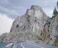
spotly Posted July 29, 2007 Share Posted July 29, 2007 Trip: Blodgett Canyon (Blackfoot Dome) - SE Shoulder/E Face Date: 7/28/2007 Trip Report: Last time I went to Blodgett Canyon was to climb Shoshone Spire. The rock quality was so good I could hardly wait to get back and try something else. There are alot of established routes in the canyon but the only thing left within my capability was the East Face route on Blackhead Dome. Advertised as a moderately run-out 5.6, 4 pitch climb, seemed like a good option. I hadn't done anything with Ken B. since climbing Snowshoe Peak several year ago so I was glad when he sent me an email expressing interest. We agreed to leave Friday, climb early Saturday then back to Spokane in time for dinner. I picked Ken up with the wife's new Yaris and we zipped over to the campground at Blodgett in time to get setup just before dark. The campground host said the bear was still making its daily visits and was now being joined by a cow and calf moose - joy. I heard some large critters real close to the tent around 4 am and couldn't get back to sleep so got up and wandereded around and woke Ken shortly after. We beat it down the trail looking for the "obvious" first talus slope at the 2 mile mark. We found a spot directly south of the dome to cross the creek and crashed through the brush, taking a more or less direct line up the steep slabs to the base of the route. I did a tic check and was pleasantly surprised that there were none to be found. The first pitch looked pretty mellow so we scrambled up it to a small juniper and set up a belay. Ken won rock-paper-scissors and took off for pitch 2 setting just a few pieces. The climbing was so mellow that we were both pretty disappointed when the top arrived. The route may go 5.6 but only if you look hard for the most difficult moves. I don't think we ran into anything belond 5.3ish (if that). At the top we discussed searching for some fun higher up the valley but in the end, the heat made the decision for us and we sought out the published decent route. From the top, we followed some thin exposed ledges/seams above the slabs of the east face to where it was easy to scramble down to the talus in a gully east of the dome. We followed the talus down (south) staying high to the right in order to get back to the base of the climb. This involved following an animal trail and some 3rd class downclimbing. From what I've read, climbing with packs was the thing to do but I think leaving packs at the base is an option if you make a rightward traverse on the decent of the gully like we did. Following the gully all the way to the creek would suck since it is quite choked with brush near the bottom. If I did the climb again, I would bring extra webbing and some rap rings then do a combination of downclimbing and rapping the route - avoiding the talus and brush in the gully all together. We scanned the terrain between the dome and the creek and chose the most open route to the trail. No tics at all. I looked hard at the brush during the hike out and couldn't find a single one. Ken looking for a log to cross on. Blackfoot Dome. The route runs from the right shoulder. A neat ridge directly east of Blackfoot Dome The route. Gotta look real hard for a 5.6 move. Ken on the second pitch. The top already? The descent was stiffer than the ascent. Gear Notes: Small rack to 2" Half a dozen slings Approach Notes: Cross the creek directly south of the dome and work west a little to more open ground. Follow scree slope up towards left of dome then traverse right on slabs under the S face. Quote Link to comment Share on other sites More sharing options...
tbrugh Posted July 30, 2007 Share Posted July 30, 2007 The ticks are gone after the temperatures start to go up...i just heard from a friend in Missoula that everything's on fire back there, good you got out before they start closing everything. Quote Link to comment Share on other sites More sharing options...
spotly Posted July 30, 2007 Author Share Posted July 30, 2007 Wow. The haze was fairly thick but we didn't see any concentrated smoke up the canyon or even smell it. Sure looks like a tinderbox in there though. Very dry, lots of fuel. Quote Link to comment Share on other sites More sharing options...
Bug Posted July 31, 2007 Share Posted July 31, 2007 Blackfoot Dome. The route runs from the right shoulder. There are some moderate to easy routes on the buttres top left in the pic. Quote Link to comment Share on other sites More sharing options...
spotly Posted August 1, 2007 Author Share Posted August 1, 2007 We hymned and hawed about hiking up there but decided to head back - shoulda continued on I guess. The temp was rising fast though. That knife-edge ridge to the east looks fascinating too. Quote Link to comment Share on other sites More sharing options...
tbrugh Posted August 1, 2007 Share Posted August 1, 2007 (edited) There are some moderate to easy routes on the buttres top left in the pic. I remember seeing that buttress a few years ago and thinking it looked like a mini-Shoshone...what are the routes like? Edited August 1, 2007 by tbrugh Quote Link to comment Share on other sites More sharing options...
Bug Posted August 1, 2007 Share Posted August 1, 2007 That knife edge ridge to the east has one route that I know of. It is out toward the south end of the ridge and goes up a crack system on the west side. It finishes through a 10A roof with a hand crack. "We hymned and hawed about hiking up there but decided to head back - shoulda continued on I guess." Up in the trees on the east side of Nez Pierce there was sometimes a little snow to melt. Otherwise you have to hump a couple gallons up there with you. I am digging for my old Torre guide. I'll post it when I find it. Quote Link to comment Share on other sites More sharing options...


Recommended Posts
Join the conversation
You can post now and register later. If you have an account, sign in now to post with your account.