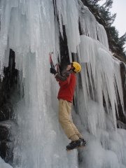
cheamclimber Posted June 2, 2007 Share Posted June 2, 2007 (edited) Trip: Cheam Peak's Sub Peak (Red Tower) - south face-ish type thing Date: 6/2/2007 Trip Report: Today me (14) and my friend Lorne (17)went up Red Tower (1400m). It's the promint Sub Peak than ends the North Ridge of the mountain. kk..time for the TR, Lorne came and picked me up from my house at 6:30 AM and we set off for Mt, Cheam. To reach the NW face of Cheam there is a small road that branches off of Highway#1 East shortly after the Bridal Falls exit. A ways up the road there is a creek/washout that crosses the road. We branched off the road here to reach the dranage creek running from the Angel. We followed the creek until the creek turns into a series of large cliffs. Just before the cliffs we branched to our left out of the gully to a ridge of trees that runs into the Angel (the everlasting snowpack below the Nw face). We hiked up the ridge of trees wich seemed to last forever but when we could see that we were near the Angel we turned back into the ully and climbed tho snow into the Angel. We could see the Sub-Peak which looked incredibly steep and horrible but kept going, there was a long snow slope branching left out of the Angel towards the Sub-Peak and we climbed that until it ended. Right at the end of the snow the hill turned into a steep cliff of fairly solid rock. The cliff was only about a 100ft tall and was incredibly easy climbing we topped out in a couple of minutes and entered the obvious split that divides the North ridge from the Sub-Peak. We left our gear on a rock out of the way of falling rock and started climbing up the split. In the splt there is a lot of really loose rock and you have to stay either right together or let one person take cover while the other climbs. We climbed up the split until we reached a tiny peice of snow and started climbing south-facish type thing od the sub-peak. The sub-peak is basically a lump of loose and crappy rock and if a riny rock is dislodged a good sized rockfall wll occur almost every time. After a bit of class 3 climbing we reached a flat spot topped by a steep part of the Peak. We carefully climbed the peice and when I put my head over the top i was looking straight dow the North Ridge at Highway#1. We had reached the top, I phoned my parents to tell them we had rerached the summit and took our summit pictures. We very carefully climbed down the steep section and descended back into the split. Once we had picked up our gear and were back in snow we glissaded down into the Angel and then slid until we had to head back onto the ridge of trees. It took forever but eventually we were back in the creek and then back at the car. The entire trip took about 8 hrs but could have been done faster (or slower). ^Lorne in front of the Sub Peak^ ^me on the sub peak^ ^In the split^ ^Me on the Summit^ ^The first cliff^ ^The Sub Peak (loose rock or what)^ ^The NW face of Cheam^ ^Looking West in the Angel^ Gear Notes: All I took was my ice-ax but I can understand if you wanted a rope because of loose rock.(be very careful of loose rock) Edited June 3, 2007 by cheamclimber Quote Link to comment Share on other sites More sharing options...
cheamclimber Posted June 6, 2007 Author Share Posted June 6, 2007 By the way..had anybody else ever done this or thought about trying it Quote Link to comment Share on other sites More sharing options...
MountaingirlBC Posted June 7, 2007 Share Posted June 7, 2007 Nice job guys and great pics! We were up there last weekend from the other side. Quote Link to comment Share on other sites More sharing options...
Bill_Simpkins Posted June 7, 2007 Share Posted June 7, 2007 Very nice. Quote Link to comment Share on other sites More sharing options...
John Frieh Posted June 7, 2007 Share Posted June 7, 2007 14!?!? Nice TR kid... looking forward to the next one Quote Link to comment Share on other sites More sharing options...
olyclimber Posted June 7, 2007 Share Posted June 7, 2007 Holy cow, that is a pile of rocks! Nice TR Cheam, I look forward to hearing more from you. Quote Link to comment Share on other sites More sharing options...
Rad Posted June 7, 2007 Share Posted June 7, 2007 Thanks for posting. Your photos illustrate why sometimes it's good to have a helmet even if you plan to be unroped. Keep exploring! Quote Link to comment Share on other sites More sharing options...
AlpineK Posted June 8, 2007 Share Posted June 8, 2007 Right on This all reminds me of stuff I was doing when I was 17 or 18. Keep it up. There's cool stuff in your future. Quote Link to comment Share on other sites More sharing options...
Toast Posted June 8, 2007 Share Posted June 8, 2007 Nice job :tup: Now, let's get you some helmets Quote Link to comment Share on other sites More sharing options...
cheamclimber Posted June 8, 2007 Author Share Posted June 8, 2007 ya, im getting a helmet from MEC some time soon. I'm planning on doing the North face of Cheam in 3 weeks and I want it for that one!! Quote Link to comment Share on other sites More sharing options...


Recommended Posts
Join the conversation
You can post now and register later. If you have an account, sign in now to post with your account.