


zoroastr
-
Posts
244 -
Joined
-
Last visited
Content Type
Profiles
Forums
Events
Everything posted by zoroastr
-
Thanks for the merciful comments on my beginner's photography. I just bought a Canon A510, which has a macro mode. I'm very happy with the results I'm getting both for close-in shots and the wide-angle shots you can make with the software that stitches multiple images together. I sound like an ad for Canon, but I'm happy with the camera. Still, I have to say that the main reason I bought this particular brand was that the model in question was on sale at Fry's for under 150.00, and that I'm sure many other brands are at least as good at this price point. Anyway, thanks again...
-

[TR] West MacMillan Spire- West Ridge and summit bivy 7/26/2005
zoroastr replied to DonnV's topic in North Cascades
Gr8 shots, Donn. BTW: the "two young studs" who did the earlier 6 1/2-hr climb are: Erick Johnson - 34 years old, and John Cain [zoroastr] - 47 years old. --If we happen to meet on the trail, you'll know me by the gray hair and the faint aroma of Ben Gay and pipe tobacco... -
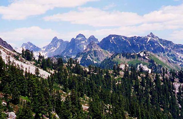
Summertime, and a climber's fancy naturally turns to thoughts of massive, grandiose, high-altitude objects. Still, it seems that some of the most memorable things about this season are the humblest in scale... A bumble on a thistle... Vanity, thy name is "Butterfly..." Outta my way! Free Food! What brings these little guys out in occasional hordes, I can only guess... Cheers...
-
Nice Job! I remember that route from a couple seasons back. The towers were a blast and the exposure relentless--very thrilling! My partner and I experienced the same route-finding difficulties on the way out, finding the elusive 3rd-class freeway only after a sketchy hour or so on an exposed 4th-class scramble traverse of the same descent route. I guess the key is knowing where to stop rapping. Anyway, this problem, combined with a longish rope snag earlier in the day, made for an 18-hour day car-to-car--exhausting but rewarding beyond measure. --congrats A shot from one of the towers midway along the route...
-
Climb: Vesper Peak - Sperry Peak Traverse-scramble routes and connecting ridge Date of Climb: 7/23/2005 Trip Report: My Climbing partner, Erick Johnson, was out today with an ankle injury, so I wanted to grab some miles and smiles on some tamer peaks. To this end, I left Redmond at 6:00 am with the idea of grabbing Vesper and Sperry via their respective scramble routes. The upshot: Vesper = simple; Sperry = kind of a pain, but nice! This is a simple T.R. for a simple climb. I hit the trail around 8:30am, hiked up to Hedlee Pass and took obvious climbers' paths to the top of Vesper via some very fun, low-angled slabs, sat on top for an hour snapping snaps, voyueristically reading other peoples' register entries [weird] and generally ooh-ing and aah-ing. Here's a snap of the Vesper Glacier and Copper Lake. I then headed over to Sperry [i think that's what it's called] via the easiest line I could find on the connecting ridge. Looking back at Vesper's North Face from the Vesper/Sperry ridge: The climbers' path on the ridge is spotty but useful until you're a couple hundred feet below the Sperry summit--then you're on your own, and it gets kind of nasty. Thankfully, there are always vegetable belays within easy reach. Sperry's actually a very nice summit. I wonder if there are gully options that take you to the approach side of Hedlee Pass...hmmm... Here's a shot from a tarn on the upper slopes of Sperry... ...And a quick snap of that un-be-freaking-lievable slab ridge leading up to Big Four! P.S. I met another CC poster named "Magellan." We chatted about the weirdness of the upper portion of the route on Sperry. Hi Mag! --cheers Gear Notes: I brought: * stout boots * ice axe [not needed] * food [desperately needed] * a shell [never worn] * .mp3's [solo hike, duh!] Approach Notes: Trail is bare. Don't let Vesper's foreshortening make you think it's any kind of challenge--it's a jog.
-
We did actually jog a bit. This was not really "climbing," but a kind of ultra-light alpine cheating. My small cyclist's pack probably weighed less than five pounds and contained exactly the following: 1. [1] box smore's-flavored Pop-Tarts. 2. [2] bananas 3. sunglasses 4. sunscreen 5. crampons 6. a light shell layer 7. camera ...that was it. No water or water container, no headlamp. It was actually kind of stupid, and I have to say if anyone is considering doing the same thing, make bloody sure you're out of the upper wooded section before light starts to fade--even with perfect visibility, we lost the trail three times up and three times on descent. Still, I think our strict turn-around time policy was conservative and kept us relatively safe. --cheers
-
UBB2-ML-479206-ML- Moved to Route Reports section so it doesn't get lost in the climber's board. Nice pics.
-
Partner Erick Johnson and I decided once again to probe the outer limits of our light-n'-fast peak assault capabilities this last weekend. All I wanted was a relaxed hike up Cashmere Mountain to see what's at the end of Eight-Mile Road and to take a look at where they're trying to put that research tunnel thing. But EJ came up with the idea of trying to snag WMS in a day. Goofy, I thought, but we'd heard at least one rumour of some friend of a friend of an aquaintance who'd maybe done it once before in a day, and that was good enough for me, so off we went. Times were as follows: Left Redmond @ 5:30 am. On trail at 8:07 am. Topped out @ 2:40 pm. Took it kind of easy on the way out, but still made it back to car well before dark, wishing we'd spent more time in that unique and amazing Terror Basin. I posted a report and some pics at Summitpost.com: http://www.summitpost.org/show/mountain_link.pl/mountain_id/5209
-
[TR] Sherpa Peak- Northeast Couloir to East Ridge 6/19/2005
zoroastr replied to MCash's topic in Alpine Lakes
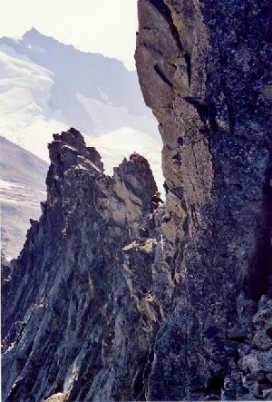
Yes...didn't look for a log. Was is in that pile of stones? Here's a shot of Stuart from the summit blocks. Like you, we gave Balance Rock a pass. -
[TR] Sherpa Peak- Northeast Couloir to East Ridge 6/19/2005
zoroastr replied to MCash's topic in Alpine Lakes
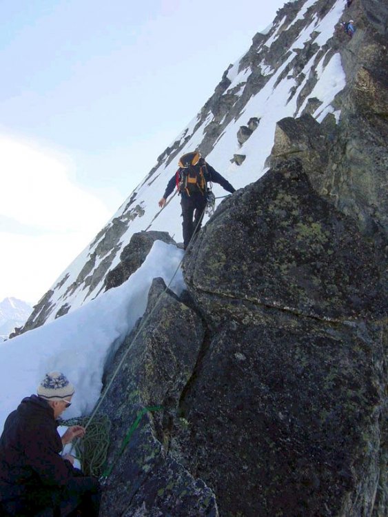
After helping some people clear a big blowdown on the road to the trailhead, we weren't on the trail until about 09:45, and in the couloir at around 1:30. When we did the route, the Couloir was pretty solid, and took longer than we'd expected. After topping out, it was late afternoon, and we didn't really want to back down the ice, so we headed down the other side of the ridge, climbed up and took a look at the Sherpa Glacier which was also totally solid, so we just headed back down into the valley, crawled under some big rocks, shivered 'til it got light, then walked around some rock ribs, reached the low pass between Argonaut/Sherpa and strolled out for a nice Monday morning breakfast in Leavenworth. I had several pounds of Chinese take-out at Safeway. Later that afternoon, I downed a family-sized pizza while making plans for dinner. -
You might as well stick to the PCT if you're new to the area--the Commonwealth basin trail does cut alot of time, but there's also some serious potential for getting lost if you're not familiar with the topography or and/or good at working your map/compass. The bigger challenge for the first-timer is finding Bumblebee Pass. Here's what you do: Assuming you've opted for the regular PCT, right after the trail passes the shore of little Ridge Lake and starts to traverse a large boulder/scree slope, start taking note of your distance. You'll start noticing occasional shallow, rock-filled gullies that lead all the way down to Alaska Lake [lake is on your right, large, and several hundred feet below]. Bumblebee Pass is actually the top of one of these gullies, but it's located...I would guess maybe 1/2 mile from Ridge Lake along the PCT. The point where you leave the trail and head up to the pass is also located at a bend in the trail and the climbers' path is visible to the discerning eye. It was also flagged with a small yellow ribbon as of last weekend. --hope this helps
-
Apart from small, useful trailside remnants, the way to Bumblebee is totally snow free. As Klenke sez, any snow left in the actual Thomson basin will only improve your speed getting to the start of the climb. What r u doing? West Ridge? ...my fave! In fact, I'd love to repeat on this route with anyone who feels confident they can follow the mythical Commonwealth shortcut all the way to the Katwalk. I usually take the Commonwealth "abandoned" spur as far as the point where it joins the PCT, but I would like to ferret out the much talked about thru trail.
-
[TR] Chickamin Peak- PCT scramble - day trip 7/18/2004
zoroastr replied to zoroastr's topic in Alpine Lakes
...hmmm...didn't notice the inscription, but i'm definitely intrigued. Regarding the Gold Creek option, I've always found that trail to be a bit 'shwacky due to lack of maintenance, but it's definiitely flatter and quicker. Part of my Chickamin adventure is the deliberate effort to get alot of miles in, so I stick to the PCT approach--a no brainer, but a great zone-out hike if you're packing a nice stereo.. BTW: if anyone has a spare minute and one of those topo programs that spews out mileage and altitude stats, maybe you could give me the numbers on the Chickie trek...i'd be grateful. cheers -
Climb: Chickamin Peak-PCT scramble - day trip Date of Climb: 7/18/2004 Trip Report: Took a break from climbing this weekend in order to make my annual pilgrimage to the top of Chickamin, a very pretty summit and a fabulous day hike that offers local access to one of the most spectacular sections of the PCT. The first six or seven miles of the 13-mile approach are a bit tedious and familiar ground to any climber who's succumbed to the lure of Mount Thomson's charms. Around Joe Lake, however, the views really open up and the hiking becomes pure pleasure as the rigors of the trail vanish in an orgy of visual splendor. A bonus: although the second half of this approach can be quite dry in late season, right now the size and distribution of snow remnants is optimal. In fact, all I took along for hydration was the plastic bottle from my bike--just kept topping it off with snow for a day-long supply of ice water! The routes up "Chickie" are plentiful, and, once your approach dues have been paid, feel free to let your imagination run wild. Since I usually do this one alone, I prefer the route described by Becky, whereby Chickamin is bypassed along the PCT to the point where the ridge forms a saddle just below the start of the Four Brothers formation. At this point, head up to the saddle a few hundred feet above, negotiating easy rock ledges and steep heather. Once the saddle is reached, take in stupendous views of the Lemah Group, Three Queens, Spectacle and Chickamin Lakes, Hibox, Alta and innumerable distant peaks. The way from here is obvious: a broad, airy ridge leads to a nice summit block that can be scrambled any number of ways, including some low fifth-class options. [...in the attached pic, Chickamin appears as the pointy thing on the right] Gear Notes: Mini pack, light boots or cross trainers, mp3 player [a MUST!], asbestos feet. Approach Notes: Stats. Total miles: 26-27. Departed Snoqualmie Pass PCT trailhead at 09:30am, retuned at 07:30pm. --actually made it back to Bellevue well before dark--these early-season days are gr8!
-
Climb: Prusik Peak-West Ridge - Day Trip Date of Climb: 7/10/2004 Trip Report: Yesterday, Erick Johnson and I naively agreed that Prusik would be a good candidate for our typical hit-'n'-run day-climbing style. I'd done the Enchantments loop three times before as day hikes, but the negative effects on the legs of 27 miles of rocky trail had long since faded from my short-term memory, and the idea of climbing Prusik in a single car-to-car push sounded reasonable. A day later, I find myself shopping on-line for a nice pair of crutches. Seriously, the climb went well, but if there's any justice in the universe, I'm sure that a special place in hell has been reserved for the author of the guidebook who claimed that the approach from the Snow Creek side is only 10 miles long. I could be wrong, but by the time we reached the base of the route, my legs told me I'd covered at least 13 miles. But enough nitpicking. The West Ridge is a wonderful route, offering a really good variety of mid-fifth class moves in a setting of unmatched beauty. Lots of stemming, lie-backs, mantles, and a short but exposed 5.7 slab. The four or five-pitch climb ends at a really nice, roomy summit with views to die for and a bomber, bolted rappel station that starts a series of four quick raps to easy ground and a short hike back to the start of the route. Although our experience was hampered by deteriorating weather, including some light but unsettling snow flurries during descent, a really hideous rope snag that required a sketchy up-climb retrieval [kudos to E.J.], and, of course, the exhausting 25-mile forced march, I found Prusik to be well worth the effort. Stats: Roundtrip: 25 miles. Departure from Snow Creek trailhead @ 09:30. Returned 13 hours later, miraculously refraining from breaking out Erick's headlamp. --will post a pic or two when they come back. Gear Notes: Day packs, small rack of nuts and cams to 2". Approach Notes: Trail clear, dry, and interminable!
-
Toast... Any mountain bike with at least 1.25" tires would work well; knobbies even better. The whole road section is bikeable with the exception of the washouts, which might even be fixed by now. If not, you just have to carry the bike for a few feet over a big log--no prob. Fair warning: off-road gears recommended due to some steepness on the way in, but you'll make the three-mile descent in ten minutes or less! p.s. I've attached a pic of the start of the climb. It was taken by Iceguy who graciously sent it to me after my partner's camera battery died.
-
Climb: Forbidden Peak-West Ridge Date of Climb: 6/20/2004 Trip Report: Partner Erick Johnson and I had intended to climb both Mt. Torment and Forbidden Peak during the Father's Day weekend, but we arrived in the B. Basin somewhat tired and late, and so opted for a relaxed Saturday in camp. The rest day payed off and the Sunday climb up the West Ridge of Forbidden went well. Having climbed the East Ridge Direct last October during an unseasonably warm and sunny weekend, we were looking forward to what we thought would be a much shorter and slightly less technical ascent of the West Ridge--not so! The WR is shorter, and the descent is trickier, but they feel about the same in terms of exposure and commitment. Early in the morning, we had no problems in the gully [see Iceguy's TR for a good description of current gully conditions] and were on the ridge quickly. The eight or so pitches of mid-fifth class ridge climbing were fun and occasionally athletic, with constant, huge exposure and very nice aerial views of the Boston and Qien Sabe glaciers, Moraine Lake [sp?] in all its turquoise splendor, and innumerable surrounding North Cascades peaks--there's always plenty to look at during extended belays. The summit is magnificent, located at the center of a perfect intersection of the three pyramidal ridges. The apex of the peak is also the home of a huge population of ladybugs. Linger for more than a few minutes, and they'll be all over you. I don't think they bite, though, and they look kewl. I'm a bit of a newb, and this kind of route is right at the limit of my psychological comfort zone. Still, I had a great time on the notorious descent, enjoying it even more than the up-climb. Erik and I made good progress down the ridge, and encountered no difficulties on descent, apart from the miserable late-afternoon snow conditions in the gully and the slopes below the 'schrund. Arriving back at camp, located on slabs above the solar toilet [currently snow-buried], we paused briefly and feasted on a strange but remarkably tasty one-pot concoction made of instant mashed potatoes, Lipton chicken soup, Top Ramen, and diced salami--pure ambrosia! Donning wet boots and hoisting heavy packs, we bolted for the trailhead, making the car before dark. Gear Notes: Two-day pack, axe, crampons [handy, but not really necessary in the gully], rack: nuts to 2", several small to medium cams, lots of runners [including a couple of biggies for lassoing endless horns]. Approach Notes: Plan on walking an extra three miles from the Eldorado trailhead where the gate is closed for the foreseeable future, owing to major washouts up-road. Kick yourself as you notice several other more intelligent climbers mouting bicycles for the extra road section. Also: remember to change you camera batteries--ours were dead, so the attached pic is from last year's East Ridge climb.
-
Spent a nice afternoon on the Becky Route yesterday, and after finishing the climb, we drove down the road a bit in order to gape, slack-jawed, at the Crack route. As a relative newb, I'm still trying to get my mind around the idea that people actually climb routes like this. One possible benefit of having succeeded on the "Crack:" if you ever find yourself on trial for murder, your CC trip report can be offered as conclusive evidence for insanity...
-
It's a perfectly good Black Diamond [purple color] standard axe, longish [i'm 5'-11" and in my boots it almost touches the ground]. Used but in fine shape. Hurry now and buy the axe that's been to the summit of Rainier God knows how many times! price: $20.00 If interested, reply to: a-johnca@microsoft.com
