Chris Hopkins
-
Posts
59 -
Joined
-
Last visited
Content Type
Profiles
Forums
Events
Everything posted by Chris Hopkins
-
Washington Pass conditions report
Chris Hopkins replied to Chris Hopkins's topic in the *freshiezone*
This weeks WSDOT report. " Hi all, Bob Hopfield reports a 4 mile gain for week 4 "At the end of day on Thursday, Jim and his Kodiak blower made it to milepost 152 (about a mile shy of Swamp Creek). Snow depth there is 42 inches on the centerline. Temps this week were in the upper 30’s low 40’s. Not much in the way of downed trees, or other issues, but we did find a minor washout that needed repair just east of Granite Creek caused by a plugged culvert pipe. On the east side, the parade of caterpillars, snow cats, snow blowers, graders and loaders continued. The pavement is visible to milepost 163, a gain of 4 miles to the first of the Liberty Bell chutes. The week began near the end of the Cutthroat Ridge avalanche zone with 34 degree temps, it was snowing with 7 feet on the centerline. Lloyds Logging's rented D-8 was Mark Bokken's this week. The County’s rented D-5 was Duane Wolley's, the giant loader was Bill Hoffman's, the grader was Jim Melton's and Jason Newman and Tyler Miller were assigned to the Kodiak snow blowers. (The avalanche crew handles their snow cat with a blade to knock down high spots for the blowers and their snowmobiles to monitor slope stability above the road.) The avalanche crew tried some control blasting but the new snow and cold temperatures in the chutes yielded little. Mike Stanford says they are 40% done with LB1. They only cut one lane up to there, leaving one lane with snow on it in case they need to walk a caterpillar back down to Cutthroad Ridge to clear new debris if those chutes start spilling. In Mike's words, "The good news is, they are almost to the summit" and "The bad news is, they are almost to the summit". "There's real concern with so much snow still up high and we are seeing big releases with this kind of snowpack all the way from Chinook to Alpental to Stevens". Don Becker said “We need warm temperatures to move the snow out of those chutes.” The forecast is for about 3” of new snow tonight to tomorrow morning, then freezing temps until Monday when the forecast calls for dry and some warming through Wednesday. Please check the avalanche conditions before you head up there this weekend." -
Washington Pass conditions report
Chris Hopkins replied to Chris Hopkins's topic in the *freshiezone*
Went up to the Silver Star col yesterday. Lots of recent solar gain wet slide activity noted on east and west faces, mostly originating from Rocky areas. There was one notable resent slab Avalanche which had a crown just around 3 feet that ripped out below the ridge rock wall deposition Zone ,north face, Lookers left of Silver Star above Varden Creek. Skied some good wind affected powder down the main fall line. Before hitting the basin we climbed back up to a ridge and headed north to a different area called "The Bride" which is a high point around 7030'. The first 800 ft was refrozen solar crust with powder seams in shady areas. We were a little late for hitting this whole area as the rest of the way down was refrozen solar crust. Even very difficult for traversing, except for the snowboarder, in our group of three, who didn't seem to have any trouble with the crust and ripping turns. Sometimes skis just have too many edges. All in all we had to deal with about 2500 feet of crust. Fortunately when we got into the treed, downed logs, bare patches, stub areas for the last 600' or so, the snow was consolidated and soft enough to make turns. It took us 2 hours to get down and out of 'the bride', 8 p.m. at the highway, which is close to 4,000 vert feet to the highway 20. It was in 'The Bride' where we saw the most of the big recent solar inspired avalanches and had to cross debris piles in a few places. One very large solar inspired Avalanche on a west- north- west facing rocky cliff area that deposited large chunks of debris on the slope below and involving surface layers, had occurred sometime that day before we got there. -
Washington Pass conditions report
Chris Hopkins replied to Chris Hopkins's topic in the *freshiezone*
Did a solo tour up the 'powder cache' (3900 vert) today approximately (8 miles east of Washington Pass) 9 to 10 inches of new at 6600 feet and 17 total down to the last hard crust. Wind at the 6900 foot Ridgetop was producing some surface slab. Top 1500 vert feet was good powder. Then the snow transitioned into wet cotton, then into creamy butter and finally the last 600 vertical feet to the road was slush from rain soaking. Very low cover down low, lots of logs and stubs sticking out. I did a ski Cut just Above the 40 degree roll to the skiers right side of the top gully. Before that roll the terrain runs around 20 degrees. The ski cut produced a propagating crack immediately above the roll in that lesser angle terrain. I probed the crack and it was 2 ft deep down to the crust. Needless to say I didn't ski that steeper line below the roll (known as Joy's Line) and went further skiers right for a safer entry into the tree Glades off the ridge. Saw one natural release at around 5500 feet (guess) that came off a corniced rocky area and it entrained the snow down to a hard Crust which was only a foot deep at that point and ran approximately 200 vertical feet. D1.5 Not looking like corn around up here anytime soon. -
Applauding risk acceptance beyond your own limits
Chris Hopkins replied to glassgowkiss's topic in Climber's Board
https://www.adventure-journal.com/2016/10/10-common-missteps-of-avalanche-pros/ -

-
@BCMATT Quote: "Multiple industries recognize this language as something that is very dangerous and training the general public in this language starts with their first avalanche course. " This is exactly the point of why my friend and I were discussing the use of the term low probability. I don't think that we are at odds with what Karl states so eloquently. So how do we get everyone on the same page? What are the challenges? I have some ideas. I'll give one but most likely it will be controversial and I'll get accused of promoting a granny state and be banned from the planet , but here goes. I wrote a letter to the Forest Service where I proposed a permit system for winter time Backcountry access to publically owned land. In order to receive a permit some sort of educational or experience standard would be required. Education is where I believe that commercial guides play a big role. But that requires full disclosure and analysis of safety records, transparency, and accountability in order to encourage trust. It's time to stop playing games where Public Safety is concerned. A permit system is not so far fetched as far as safety concerns go because many Industries and associations require a certification standard. For example I was required to become a certified diver before I could purchase compressed air to fill my scuba tanks. There was a lot of course time involved in order to receive that certification, way more than an Avy 1 course. It's not just the individual who's at risk when bad safety habits are practiced. Individuals or group decisions, including commercially guided trips, often can have a negitive impact upon risk exposure experienced by other groups. I have other ideas but would like to hear other input on this issue. For example in the rock climbing world, how do you keep climbers from dropping rocks on each other's heads. Once again thanks for having this civil discussion here because I believe that communication is key to understanding. issw-2000-037-045.pdf
-
If you make it to the Morrison Creek trailhead, just head North from there instead of going up the road to the South climb trailhead. You'll still be able to connect with the South climb. May want to take a GPS with you though because it's easy to drop too low heading heading back to the Morrison Creek trailhead.
-
Quote from BCMatt. "Low probability high consequence is not down playing the problem, it is making clear how dangerous they are despite the difficulty in triggering them" My friend, a former mountain guide and well known within the climbing community (although he doesn't promote himself), and I were having this discussion why the use of the word "low probability" downplays the risk hazard simply because it leads to confusion as to what the actual risk of triggering that avalanche problem is from a human perception point of view. Here's an example that may lead to confusion especially to the uninformed risk taker. https://www.nwac.us/blog/2017/03/26/ruby-mountain-low-probability-high-consequence/ "It is extremely unlikely, if not impossible, to human trigger such an avalanche. It takes something massive (rapid snow or wind loading, huge amounts of rain, large cornice fall) to trigger such a Deep Slab" Does the use of the word, "low probability" lead people to believe that it's nearly impossible for a skier to trigger such an avalanche so therefore why not take the risk? What about a snowmobiler or a group of 2 or more skiers on the same slope? What's the probability now? (We all know that a snowmobile and closely spaced skiers or even someone Landing a big jump transfers more energy to the snowpack and makes triggering an avalanche more likely.) Also the probability of that low probability trigger event increases with recent additional loading, so how is that probability now stated. Low probability with increased probability for trigger? And then there's what I call the domino effect trigger on a shallow slab that provides enough energy to trigger a deeper slab. I believe the statement creates confusion, especially among the uninformed Risk Takers, that it's nearly impossible for a skier to a deep slab instability (greater than 3 feet) yet it happens.The literature is clear that deep and persistent slab Avalanches can be triggered from shallow areas within the snowpack such as on or near rocky Terrain features. My understanding of risk probability is that odds increase with the number of Trials. More and more people are exposing themselves to this Avalanche problem as is demonstrated in that Ruby Mountain close call. Ten years from now will we still be considering deep slab instabilities to be a low probability human triggered avalanche occurance? This link to a skier trigger Avalanche incident a pic below. http://avalanche.state.co.us/forecasts/help/avalanche-problems/deep-persistent-slab/ "A snowboarder triggered this Deep Persistent Slab near treeline, well down in the path." But maybe I'm missing something and value your input. additional reading https://www.yumpu.com/en/document/view/12169021/analysis-of-the-durrand-glacier-avalanche-accident/20 http://nationalpost.com/how-a-massive-avalanche-changed-b-c-s-backcountry-culture-and-shattered-one-guides-life http://arc.lib.montana.edu/snow-science/objects/issw-2006-491-497.pdf I really like the way that K. Klassen presents information in an easy and understandable way linked below. http://www.avalanche.ca/blogs/novemberfacetsmarchlphccycle
-
Washington Pass conditions report
Chris Hopkins replied to Chris Hopkins's topic in the *freshiezone*
Here's a link to a observation that I had given to a friend of mine in 2016 and urged him to file a report since I had no internet access at home to that site via a flip phone. https://web.archive.org/web/20160515085953/https://www.nwac.us/observations/pk/444/ We were trying to increase awareness of the Avalanche Hazard along Highway 20 during the Spring Road clearing when bicycles are allowed past the gate. The local bike shop, which my friend was working for, was sending families up that way out for pleasure cruises and he was concerned. I had gone up with my partner that day expecting that we would see some Avalanche activity. As we were going up I noticed that a family was coming down complete with Towing young children on trailers. We did keep an eye out looking up the slide paths as we passed below, however we were grouped together which is not correct protocol while traveling in avalanche Terrain. May not have mattered anyway since we didn't have shovels with us or Avalanche transceivers. That monster Avalanche came down Within 30 minutes after we passed under that slide path on the ride up. And of course coming back we had to climb through knee deep penetration slushie Avalanche debris (at least 6' deep at the toe and 150 to 200 feet wide but 15 to 20' deep feet where it hit the highway) while carring our bicycles, which increased our exposure to another slide from possible Hang Fire or another feeder path. Am I embarrassed by this incident? Well yeah slightly. Why would I choose to publicly embarrass myself. Lead by example. These types of incidents are important to report in the interest of Public Safety. -
Washington Pass conditions report
Chris Hopkins replied to Chris Hopkins's topic in the *freshiezone*
for those that don't subscribe to the,WSDOT Information services, here's the latest,plowing update. " Hi all, It's been a rainy and snowy three weeks since the crew on the west side started clearing from the Diablo gate - The roadway is cleared, the jersey barriers removed, the ditches are groomed all the way to Granite Creek - that's 14 miles. Monday the blower heads east into the 4' of snow on the pavement bound for Rainy Pass about 9 miles and another thousand feet of elevation ahead. Snow and rain were companions for the eastside crew that started work Monday from Silver Star gate but the 40 degree temperature and no wind made it all bearable. Initial going was slow as some of the equipment didn't like the 3 to 4" ice floor under the 3' of snow at the gate, but by Tuesday Duane on the D-5 (rental) caterpillar, Jay on the grader and Jason and Tyler on the Kodiak snow blowers won that battle and by Wednesday had cleared 4 miles past Lone Fir campground to Cutthroat Ridge avalanche chute #1. By Thursday, churning through 5+ feet of snow, they had cleared another mile to CR#7. That included cutting through the slide and debris that came down over the weekend from CR#4. Monday, the second rental caterpillar joins the parade - Lloyd Logging's huge D-8. It will work ahead of the rest of the crew to start cutting down the 50' pile of snow over the road at Liberty Bell Mountain. Good progress, but the downside is that not many of the 30+ avalanche chutes have let go of their snow and the forecast calls for another week of mixed rain and snow and there's some freezes in the mix which might delay the natural slides we're hoping for. As usual - we're at the mercy of the weather. If you're heading up past the gates this weekend - please check the avalanche conditions first. Until next week, (for more frequent updates follow: The WSDOTFacebook page, Twitter and the 2018 Flickr reopening collection. Jeff & Andrea" -
Thanks Matt for your reply. Very refreshing. I'm looking at my 19 93 copy of the Avalanche handbook and on page 67, I can't find that table you are referring to. However on page 59 from my copy here's a quote. " the influence of a crusts can significantly alter the conditions for transport and deposition of water vapor in a dry snowpack. Faceted Crystals sometimes form above crusts to produce a future serious Avalanche situation when buried by subsequent snowfall. In fact, weak bonding of snow above crusts is the most important feature of crusts with respect to Avalanche formation." " however the presence of crusts, since they are relatively impermeable to Vapor transport, can also allow faceted snow to grow immediately below a hard layer even when the surrounding crystals are well-rounded." I think that is supporting evidence from that book that confirms what I'm saying that it's not the crust themselves that when buried are to be considered persistent weak layers. It is the crust-facet combination that constitutes persistent weak layers, so I maintain that the Scruggs article is misleading. I tend to agree with the following opinion from an article in the Avalanche Review page 30. Pfd attached. "What Makes a Crust Problematic? In my opinion it is not about the crust itself, but rather what is around the crust. Is the crust bonded to the adjacent layers, or are there facets around the crust leading to poor bonding? The conditions under which the crust forms, and the subsequent temperature conditions through and around the crust, are critically important." I'll try to adress some of your other points, without violating my recent administrative warning which restricts what I am allowed to discuss here, but now i have to. head out for a dog ski. Thanks again for the intelligent debate. TAR3003_LoRes.pdf
-
Didn't know who wrote The Minority Report until you mentioned his name here. I was talking about that movies depiction of targeted advertising and how information is gathered on us and how that information is used. The proposed border crossing rule is just one example of how that data collection may be used. I didn't have my dog papers coming into Canada one time. That data was collected and every time after that, when I attempted to enter Canada I was asked about if I'd ever been denied entry into Canada. I guess they're checking for honesty against what they have on file. As far as the chattering paranoia thing, I think it's important to realize that the internet is an imperfect form of communication because we don't see each other's as visual cues, body language, speech inflection or even familiarity with the person with whom we're trying to communicate. I haven't researched it yet but I suspect that there's a strong desire for each one of us to build mental pictures of who we think the person on the other end of the conversation is. Those mental pictures would be constructs of the virtual world and not necessarily based in reality. For example, Whether or not someone's comment is being perceived as either negative or positive largely depends on point of view. My friends tend to laugh their asses off when they read much of what I write, where other folks who only know me through the internet seem to interpret them differently. Excuse me for chattering on but that's how my mind works. It's largely based in Divergent thinking. See my friends are laughing their ass right now.
-
That's really nice man. Mentors rock, they show us what is possible beyond our limits and they do it from the heart. Telling your buddy that you will catch them if they fall, that's style.
-
Washington Pass conditions report
Chris Hopkins replied to Chris Hopkins's topic in the *freshiezone*
Sorry I didn't see your post until now. The WSDOT will be trying to keep the road open to SS gate all winter. There is a rumor that FS may establish a trailhead snow park at the SS parking lot. The snowmobile congestion down by Early Winters, the typical road closure area in winter, was creating a problem for the Property Owners there. I don't blame them one bit as I would not want a snowmobile trailhead right outside my driveway and I use a snowmobile to access the skiing in the winter. -
I listen to this song alot by Dead Can Dance called American Dreaming https://www.azlyrics.com/lyrics/deadcandance/americandreaming.html American Dreaming" I need my conscience to keep watch over me To protect me from myself So I can wear honesty like a crown on my head When I walk into the promised land We've been too long American dreaming I think we've all lost the way Forlorn somnambulistic maniacal In the dark I'm in love with an American girl Well, she's my best friend I love her surreptitious smile That hides the pain within her And we'll go dancing in the rings of laughter And leave alone by the shores Feel alone in the brands of rapture And leave alone for the loss Yeah, on the lea the rising wind blows Yeah, on the lea the rising wind blows How long? How long? Here alone on the grounds of allegiances We've left behind Turned back by the foot of the doorway Never lost and found We've been too long American dreaming I think we've all lost the heart Forlorn somnambulistic maniacal In the dark Yeah, on the lea the rising wind blows Yeah, on the lea the rising wind blows How long? How long?" I've been with the same lady for 41 years who I met when she was 18 years old. I'm in love with an American girl and she's my best friend. Honor above all.
-
Bears are ok. I like wolves too.
-
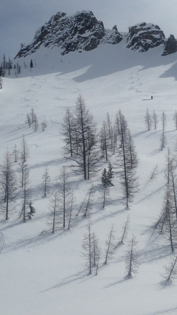
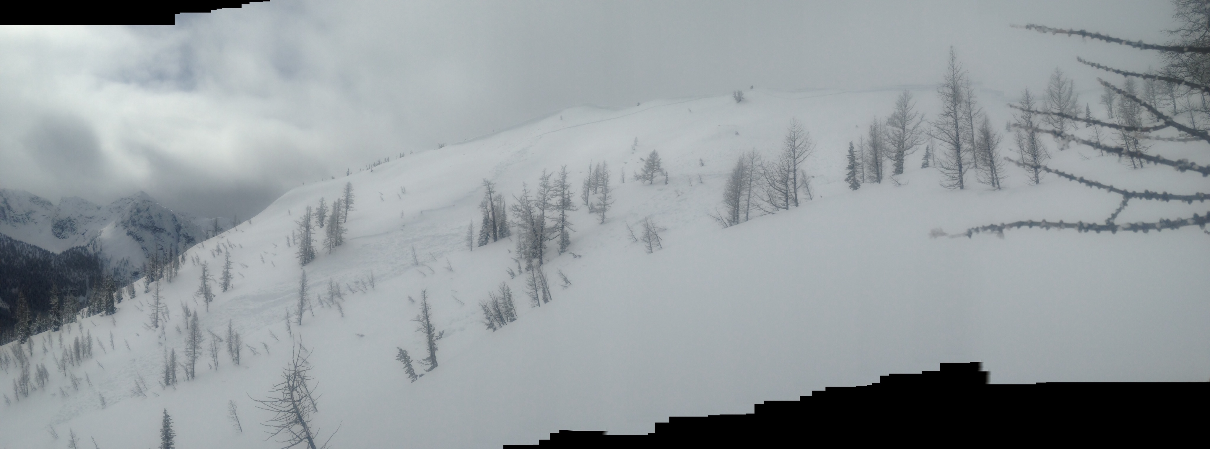
Washington Pass conditions report
Chris Hopkins replied to Chris Hopkins's topic in the *freshiezone*
Here is a report from Ed from his Sunday ski. Ed was a pro patroler for many years at Stevens Pass and one of many locals here who volunteer time freeguideing the area. Ed's report. "Wasn't good light for this panorama of west ridge of Portley on Sunday. Slide was a few days old. Looked like 2 to 3' deep crown went all the way up to the right side of the photo. Main debris pile in that mainline run we often do directly to the basin. As I hit the steep part of my normal route up, I dug out a column about 2 1/2' to same crust and got pretty easy shear. W/ solar warming and all, I turned around and headed for Liberty Bowl. Good turns up high, suction snow down low, both sides." First pic is from the day of the first report (edit didn't detail this day it was the two days prior )on this thread page taken by Ed of me skiing Good2Go bowl which is skiers left side below the Ridge wall that trends west off of Blue Peak. The whole basin area is known as "Liberty Bowl". Second pic shows south- southeast face of Portly Basin crown and debris run. Both areas are truly near Washington Pass.

-
people texting and web surfing while driving are a bigger hazard then any type of forest wildlife. Cities are freaky places also. "Thank God I'm a country boy". yes vote from me.
-
Washington Pass conditions report
Chris Hopkins replied to Chris Hopkins's topic in the *freshiezone*
I consider TGR to be one of the worst commercialism slimpool sport related internet forums out there. When I present these issues here in my home state at online forum sites, my hope is for intelligent debate of the particular issue that I am presenting. However because these issues can be controversial I tend to get a lot of "Kill the Messenger" type stuff. The use of the word Vendetta comes up a lot. A lot of the issues I present online have been brought to me by other people who know that I'm involved in public land issues and know that I'm not afraid to speak out. I will then research that issue for facts, and then will present that issue both online and to the public managing land agency. I never used or read nwac for it's avalanche forecasting and barely paid attention to that organization. Their biased, inaccurate or non -reporting of industry partner related (guides trips) non injury near miss accidents was an issue that was brought to me many years ago by ski partners who follow nwac reporting. Then we had a guided client near miss Avalanche accident in our local area where the two local guides were guiding outside of their permit area during a extented reactive persistent weak layer. Prior to that accident I had posted online about that weak layer being particularly reactive in that area ("Power Cache") where the accident ultimately occurred and I even personally notified two local guides of the reactive pwl in that area prior to that accident (one of those guides is a close personal friend of mine). When that accident occurred I wasn't going to post about it. The local guides were getting pissed at me because I already had reported about a couple of their near-miss accidents. Then I talked to a father who's son had recently been killed in an avalanche accident and he encouraged me to speak out. I checked nwac to see that the accident was not being reported accurately as far as location or that it was a guided client involment. Nwac was reporting the accident as being in the Washington Pass area when in fact it was eight miles further east where that PWL continued to be reactive. Because that pwl was reactive in that area to the east, many locals, including myself were skiing steep, open areas in the Washington Pass area where that layer was not reactive and had been well tested.A local guide even reported on nwac that we were skiing those lines, as in look at those crazy locals. When in fact, we were hearing that several non publicly reported near Avalanche incidents were occurring on commercial tours at that time. This was the case where inaccurate reporting of an instability location jeopardized Public Safety and I believe that's important information to get out. But many people don't want to hear that their icons are entangled to the detriment of Public Safety. Two days after that accident occurred, I went up and took a look at the accident site and documented on tay the exact location. The Avalanche had piled debris over the guided skin track in 4 or 5 locations. If someone have been on the skin track following they could have been Avy hosed from above. And because of that public safety concern, several locals, including myself, pioneered a new Ascent line that does not have any Avalanche exposure for the entire 3900 vertical foot climb to the ridge. Many local bc skiers, I call them free ski guides, make sure to show people new to our area that safe ascent route as well as many others in the local area. When we hear that the skin track has gotten off course and back into Avalanche exposure, we will go up there and re-break that trail back into the safe Ascent route. It's what we proudly do. Our goal is that everyone stay safe and have fun. Party on. -
Washington Pass conditions report
Chris Hopkins replied to Chris Hopkins's topic in the *freshiezone*
From the eastside right now the road is open to the Silver Star Gate. However that means access to Silver Star Mountain. WSDOT starts plowing the highway from the east this Monday the 9th. They work Monday through Thursday and request that no one use the highway past the Silver Star gate during working days. We used to have access during those working days for many years. It may have been that people were getting too close to the working crews and creating a hazardous situation, hence the loss of privilege. On Friday, Saturday and Sunday the hwy can be used and many people use the highway for bicycle riding. No licensed Motor Vehicles of course. It's important to remember that many Avalanche slide paths cross Highway 20. It's very possible for an avalanche to come down that wasn't there on the ride up, so be prepared to have to climb over an avalanche debris pile.(I've had to do that) And of course proper safety protocols need to be observed while in Avy terrain. Not a good idea to have lunch under a slide path for example. Look up the path as you cross, if your decision is to proceed. Watch out for rain events and nights that do not freeze. Also it can stay above freezing at altitude but be frozen on the highway so it's advisable to check the Washington Pass telemetry for the 6680' temps. And in the morning or late day there can be ice on the highway from the melt freeze cycles. Typically to access the skiing past the gate, I'll put skis on my mountain bicycle and head up. -
Washington Pass conditions report
Chris Hopkins replied to Chris Hopkins's topic in the *freshiezone*
Headed up to hairpin today.mank on road, getting warm, recent large slide in cutthroat slide path and several smaller ones,rain, new snow in trees about a hundred vert feet above hair pin. Talked to two skiers that turned around at the Cutthroat trailhead and they heard several Avalanches coming down. I saw a nice Avalanche coming down on the east face side of the big rock buttressed Ridge Lookers right from hwy 20 of SilverStar Creek. So beautiful, waterfall. Some of the Native Washingtonian mank skiers went up to first bowl in cutthroat. And we turned around. Forgot to bring mank wax. -
Washington Pass conditions report
Chris Hopkins replied to Chris Hopkins's topic in the *freshiezone*
Dude I'm glad you feel it's not a conspiracy spreading website cuz I'm not spreading conspiracy ideals. But perhaps you should take a look in the mirror and see the ideals you are sharing here. Nwac seems to be open to intelligent civil debate, why aren't you, especially when that debate concerns Public Safety. https://www.google.com/url?sa=t&source=web&rct=j&url=https://m.youtube.com/watch%3Fv%3DqLvGnro4Cgw&ved=2ahUKEwiLqpel9araAhXm6IMKHd03DVwQtwIwAHoECAcQAQ&usg=AOvVaw2vD7cmrd5D5qnPWvsU1xOk https://en.wikipedia.org/wiki/Critical_thinking "Researchers assessing critical thinking in online discussion forums often employ a technique called Content Analysis,[36][35] where the text of online discourse (or the transcription of face-to-face discourse) is systematically coded for different kinds of statements relating to critical thinking. For example, a statement might be coded as “Discuss ambiguities to clear them up” or “Welcoming outside knowledge” as positive indicators of critical thinking. Conversely, statements reflecting poor critical thinking may be labeled as “Sticking to prejudice or assumptions” or “Squashing attempts to bring in outside knowledge.” -
Washington Pass conditions report
Chris Hopkins replied to Chris Hopkins's topic in the *freshiezone*
And here is a email response from nwac to that observation poster concerning the observation that I'm talking about in the above posts. While I never found this policy statement on their web site concerning the recreational observation page, I think it should clarify what the intent of the page is. I'm also happy to see that nwac is open to " debate and criticism when it's offered in a civil manor". That is after all the intent behind my writing. To have an open, honest discussion free from personal attack on how the system can better serve Public Safety and become inclusive of all points of view. "This page is> intended for the sharing of snowpack, weather, and avalanche observations,> and not for use as a forum regarding NWAC, its staff, its industry> partnerships, or its products.>> That said, we welcome debate and criticism when it is offered in a civil> manner. Although we don't currently have a dedicated forum for public input...." -
Here is my pm to another member here discussing the linked article above. I edited for clarification. Warning contains adult content. Check your Prejudice at the door. This post is in no way meant to be a vendetta against mr. Scruggs or NWAC. The Scruggs article was a puff piece, which included two significant errors. The first one is that he reported rain crusts as being weak layers and become buried pwls. Raincrusts are not weak layers or considered PWLs. Raincrusts are actually very strong layers, so much so that they become bed surfaces, sliding surfaces. It is the snow layer directly above and below those crusts, depending upon Crystal type, bond strength and metamorphism factors that favor facet growth, that are considered to be pwls ( persistent weak layers). The second error in that article is the picture of the skier standing on top of a large cornice feature. While it's true that the skier is standing back from the cornice, cornices can break further back then one might expect. Maybe someone should have proof read that article for him. In the Scruggs article, nwac does make a valid point when asking the question of why people don't heed Avalanche warnings. One factor that your brother and I have discussed is nwac's downplaying of the risk hazard by including such phrases as low-probability High consequence Avy triggers when discussing deep slab instability. I'd like to see them actually put a number to that low-probability, if that's their claim. Another Factor would be the fact that nwac does not report accurately. The phrase "skier trigger"and "near Washington Pass" as described in one of their forecast discussions is not accurate for the incident that was reported to nwac and "generically" described in their forecast discussion. nwac had the factual information on hand for that near-miss Avalanche incident and relayed that fact to a friend of mine in an email. The facts are that the nwac reported on their forcast "skier trigger" which was actually a guide partial burial.That is different from a skier trigger. That is a near-miss Avalanche incident. That near-miss Avalanche incident occurred at Harts pass, not near Washington Pass as reported by nwac. The exact location of that incident should be included in a full analysis report that would meet the standard of professionalism for reporting a near-miss Avalanche incident. that incident should also have been included in the annual Avalanche summary, it was not. Why is that not being done? Also Nwac needs to focus on why most people don't post observations. Note that specific facts for the above discussed near-miss Avalanche incident are available upon request.
-
Washington Pass conditions report
Chris Hopkins replied to Chris Hopkins's topic in the *freshiezone*
Jon, I reread my posts and no where do I see anything that could be construed as a vendetta against TAY or nwac. I quoted that TAY thread because it was actually very complementary of my TAY thread writing and pointed to a fact, by the Tay owner himself, that NWAC members were pressuring Tay concerning my writing. All I see is factual informational reporting concerning observations from the Washington Pass area. I also threw in a situational awareness tip, like keeping an eye out for other people in the backcountry when they aren't keeping an eye out for each other. Perhaps those that see Vendetta in my writing are coming to my threads with prejudice?