

jugander
-
Posts
4 -
Joined
-
Last visited
jugander's Achievements
")
Gumby (1/14)
1
Reputation
-
 jugander changed their profile photo
 -
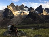
Trip: Dragontail Peak - Backbone Ridge Date: 6/15/2014 Trip Report: In June 2014, Josh, Steph and I climbed Backbone Ridge on Dragontail, a beautiful climb that culminated in a rather epic shiver bivy. Expecting a mellow weather weekend, a blustery snowstorm and temperatures well below 20F kept us pinned to the summit through the night. The story of our misadventure follows. Photos at the bottom. How could we have gotten ourselves into such a boondoggle? At the time I was really baffled, and performed a fairly careful meta-analysis of Backbone trip reports to see where we went wrong (the source of some of the extracts are cited below). By late June, alpine amnesia had set in, and I set aside the analysis as Steph (my wife) and I moved on to other climbing objectives. WIth the weather now having turned to fall and winter, I’m finally finding time to write up what we learned, for others to benefit. The details of the shiver bivy are painful to recall, but I’m going to summarize what happened, and then switch to detailed reflections on the route and our decisions. Overall, this story is a case of “light and fast turns to cold and slow,” with its own variations. For instance, before heading into the mountains we had checked some recent reports that said snow was soft late in the day and crampons weren’t necessary. We brought no crampons and one ice axe for three people with a few spare layers but no planned bivy gear. That turned out to be a major mistake. Summary of climbing: Sleeping at the Stuart Lakes trailhead, we rose at 2:30am, and were hiking in by 3am. We cruised past Colchuck Lake and reached the last snowfield before the scrambling start of Backbone around 7am, under overcast but calm skies. The snowfield was pretty hard (but not impenetrable), so we crossed it carefully in our boots. We scrambled up the toe of the formation and found what must’ve been the start of the route (the early season snow covering the base of the pitch made it difficult to discern), since one pitch of climbing put us right below the P2 OW. Josh led the first block of pitches, including the OW on little more than a #5 cam and a single big-bro (#3). He did so boldly, with a freaky run out, and that’s why he’s often called the mountain wizard. Steph took over after 4 or 5 pitches, and she smoothly brought us to the Fin and one pitch up it. We were making OK time for a party of three, but when you’re going for a grade IV in a day, OK time sometimes isn’t enough. At this point I’m going to slow down the story, because just as things switched to my lead block (beginning one pitch up the fin), it started to flurry. For those who haven’t been up there, the Fin is confusing. You access the fin via a pretty chossy ramp system that places you below a wide blank face split by a maze of cracks. From the ramp below you’re squinting to see what cracks go where, hoping whichever you chose is not going to deadend. The route I ended up taking started by following the blue line of this topo for two pitches (belays denoted by red dots): Image credit: the discussion from this 09/02/2006 TR: http://cascadeclimbers.com/forum/ubbthreads.php?ubb=showflat&Number=594125 Those two blue pitches are very nice, and go at about 5.9-. More importantly though, the flurries were growing denser and the light was visibility dimming as the temperatures dropped precipitously. While my leading and top-belaying was keeping me pretty warm, Josh and Steph were freezing, and there was a looming sense that we needed to get off the route as fast as possible if we were going to have a chance of getting down before dark. From the second belay on the blue route, I left the blue line and climbed more directly up with the goal of gaining what I had interpreted to be a key notch (found at the top of the red route on the above image) based on the beta we had (a photocopy of Selected Climbs in the Cascades by Nelson and Potterfield, not nearly as fancy as these photo overlays). About that fin variation: As I left that blue route I climbed a very nice 5.8ish crack. I saw the notch grow closer, and spotted a horizontal crack for foot-shuffling that crescented in from the left, which my beta had predicted. This was the notch we needed to gain, the notch that could get us over the fin. Warning: continue reading this section if you enjoy super detailed beta, otherwise feel free to skip ahead three paragraphs. At the top of the crack I placed a great BD #2 cam, extended it to prevent rope drag, but then stared up at a lichen-covered and seemingly blank face, with a restful stance in the notch torturing me 8 feet up and to my left. As I studied the blankness, I started to piece it together. First, I spotted a great 2 inch deep horizontal rail just to the right of the exit stance in the notch, and figured “If I can hit that money rail, it’ll be in the bag.” I continued to look around, and saw what looked like a sloper just out of reach. Maybe it’s positive? Connecting the dots, I spotted a closer tiny but solid crimp rail, which could get my hands up to the sloper. I started moving. The sloper was indeed a sloper, definitely not as positive as I’d liked it to be. Balancing to keep my hands friction-glued to it (the cold helped), I worked a foot up to the lower crimp rail and gently stood up. The “money rail” was now four feet to my left, and I was almost level with it. At this body height the sloper started to fail me, and I found a small hold higher up, for my right hand, that kept me in to the wall. I began a series of desperate thrutching bumps with my left hand, and my eyes popped with joy when my hand reached the money rail. My body swung left as I match hands, and boom! Sent! We were off the fin! Hell yeahhh!! When Josh and Steph reach the top of the 5.8 crack they were each startled to see what I’d led through the building storm. Both sent it without difficulties, but with eyes equally popped in disbelief as their bodies swung left and they stepped into the notch. Welcome to the top of the fin! I’d probably call these blank face moves 5.10b, though it’s more like a V1 boulder problem. What’s interesting is that, based on a review of CC trip reports, it seems as though many have been lured into precisely this crux before: 8/31/2012 TR: http://cascadeclimbers.com/forum/ubbthreads.php?ubb=showflat&Number=1080880 7/29/2006 TR: http://cascadeclimbers.com/forum/ubbthreads.php?ubb=showflat&Number=585360 8/21/2004 TR: http://cascadeclimbers.com/forum/ubbthreads.php?ubb=showflat&Number=387343 Summitpost: http://www.summitpost.org/backbone-ridge-with-fin-direct/210011 If you enjoy A0’ing, or if you like your 15th pitch or the day to turn up the heat two notches above what you thought was the crux, go for it! Getting off the fin: Navigating the fin through the snowstorm took time, and by the time we’d reached the notch it was around 8pm, albeit in mid-June, when sunset comes around 9pm. Atop this notch, the ridge of the fin looks down into what we now know to be the top of the Triple Couloir route. As the sun started to set, we climbed an easy pitch on the backside (Triple Couloir side) of the fin ridge, reaching a higher notch in the ridge, where the blue line topped out in the above photo. And here’s where some mistakes were probably made. With the sun down and light fading, snow in the air, and but one ice axe and zero crampons, we started to realize the seriousness of our situation, and wanted to get down quickly. We saw two options. The first was to get back onto the face of the Fin (rather than the Triple Couloir backside), hoping that things weren’t too difficult to navigate in the darkness. The other option was to downclimb or rappel into the couloir behind the fin, and exit up the couloir. Josh is very comfortable on snow and ice, a realm in which Steph and I have less experience. We discussed for a few precious minutes, and decided to take the couloir. Not knowing where the rock would lead and with visibility dimming into the snowstorm, the couloir seemed like the more secure choice at the time, even with only one ax and no crampons between us. We switched to boots. There was far too much loose gravel and choss to make the downclimb feel safe, so we opted for a short rappel down to the snow (watch for loose blocks if exercising this option). Josh went first and built a belay anchor. I followed, bringing down our second rope on my back, and belayed Josh on that rope as he climbed the final 100 feet of the couloir, chopping footholds for his boots in the hardening snow with our only ice axe (and no gear for protection). Then Steph rappelled down to join me on the snow, we pulled the rap rope, and both climbed up Josh’s cut steps by glove-pawing at the frozen foot holds. We were off the fin, but the daylight was now gone. This was actually a bigger problem than it seems, because of the now thickly falling snow. As we turned on our headlamps, snow was whipping all around us, and the headlamps did little more than surround us in light bubbles, as the light reflected on the whirling snow. By now it was probably 9:30 or 10pm (sussing out the rappel into the couloir, plus chopping steps, had taken time). We put on all the clothes we had brought (not much: little more than a micropuff and rainjacket each). We evaluated our food and water: a few clif bars, and 1.5 liters. We split a clif bar or two for dinner, saving two as a meal for the unknown future. Of note, we’re far from the first to drop into the Triple Couloir finish. Here are some excerpts from previous TRs: 07/30/2005 TR: http://www.ofb.net/~ania/life/Dragontail_Jul05/ 7/14/2013 TR: http://cascadeclimbers.com/forum/ubbthreads.php?ubb=showflat&Number=1108648 8/12/2011 TR: http://cascadeclimbers.com/forum/ubbthreads.php?ubb=showflat&Number=1031197 9/30/2006 TR: http://cascadeclimbers.com/forum/ubbthreads.php?ubb=showflat&Number=601544 The answers to that last question is yes, there does indeed appear to be a more aesthetic finish: Instead of dropping into the TC gully, it appears to be much more advisable to switch back to the face of the fin! Very good to know for future attempts! Getting off the ridge: In good daylight, we probably could have found an easy scrambling route up the rock ridge from where the Triple Couloir route ends to the summit. But we were extremely cold, and none of us could see more than 20 feet in our snow-blinded light bubbles. As we walked the flat part of the ridge southwest toward the summit, we were blocked by a giant bullet-hard snow drift, effectively forming a featureless 60 degree ice blockade. We walked the ice wall to the left, reaching the cliff above the snow slopes far below (which to us was just a void). No go. We walked the ice wall to the right, reaching rock that we couldn’t get a good read on for more than the 20 feet our headlamps reached. We were cold. Very cold. At this point, Josh entered hero mode. He picked a spot on the headwall, tied in, and started chipping a ladder into the ice. Steph and I stood on flat ground at the base of the ice wall while he meticulously engineered a passage over the ice with our single axe. Steph kept Josh on belay, though it was an unprotected one until he found protection at the top of the ice. While we huddled there below the ice wall, I have a specific memory of being awed by the inch-long rime ice cystals that had formed on the cams still hanging on Steph’s harness as she stood on the exposed slope, slowly paying out rope. I didn’t photograph these crystals, or in fact anything during the hellish night, but this is one of those visuals I expect to stay with me for some time. It was beautiful, but freaking cold. Josh boldly topped the ice wall, which was probably 50 feet tall. He built an anchor on solid rock and brought us up. At this point I believe it was close to midnight, but we soon found the trail to the summit, and were finally “on route”, after several hours of frustration within the light bubbles of our headlamps. The shiver bivy: It was midnight. Perhaps past midnight. A major advantage of getting over the ice wall that pinned us to the ridge was that we were now able to find protection from the wind that was blasting us from the west. We considered our options, scouting down the trail heading south that brings one off of Dragontail, only to find the 30 degree snow slope that one normally descends to be just as bullet-hard as all the other snow we’d battled. With no view of where the snow slope trailed off to (in the event of a fall) or how steep the slope might become further along, we were trapped by uncertainty. The snow whirling around us was not accumulating enough to give us grip, but it was just enough to blind our headlamps. The crampons were still very much at home. From the previous morning we knew that dawn was going to arrive around 5am. While the sunrise would not help soften the snow (too cold, and too much overcast), it would enable us to see where we were going. After some very cold discussions, we opted for a shiver bivy, hunkering down halfway under a boulder we’d found near the summit that provided good shelter from the wind. We uncoiled ropes for bedding, stuffed pant legs into our socks, etc.: all the tricks we could come up with. And we shivered. Leg cramps hit us from dehydration. The little water we had was now a frozen slush. Josh marshalled us on walks around the summit area every half hour or hour, when we’d try to shake the numbness from our limbs. The descent: Finally, dawn began to spread its fingertips of gray, just as the snow that had been whirling decided it was finally time to start accumulating. With the ambient light of the dawn, we could now finally see several hundred feet. We turned off our headlamps, brushed snow off our gear, and split our last two energy bars. We started the march down the rock ridge to the start of the snowfield. During the nighttime walks, Josh had found a second frozen bootpack that was better than the frozen bootpack we’d spotted at midnight. Steph and I grabbed self-arrest rocks, and the three of us roped up, with Josh at the rear with the ice axe. We headed down. To give an idea of how hard the snow was, lining the side of the frozen bootpack were the frozen plunge-holes from ice axes in warmed times, which now formed rocksolid finger pockets for steadying oneself on the descent. We crawled our way down the ice, and could soon see the top of Asgard. We had escaped! When we reached Asgard we cracked the surface ice off a pool of water and filled up on 32F H20. We were going to be ok. The descent down Asgard was a bit hairy, as often the trail was covered by large snowdrifts that were still very much frozen even at these lower elevations. We took some wrong turns, but eventually reached the lake. We painfully slogged down the approach trail, having been on the move for 30 hours. Our final car-to-car time was on the order of 32 hours, reaching the lot around 11am. No injuries, no frostbite. We drove into Leavenworth and went into Kristal’s Diner for “brunch”, aka the mother of all post-climb gorges. I devoured a chicken-fried steak, and feeling myself fall asleep at the table, excused myself to go sleep in the car as I offered to take the second shift of what would undoubtedly be a multi-shift drive back to Seattle. I passed out immediately, took over driving just past Stevens, and we were in Seattle by mid-afternoon. Lessons: Encountering frozen snow without crampons or ice axes can be a very serious showstopper. Be absolutely certain that the high country snow is in fact soft if deciding to leave them at home. We relied on a trip report that was less than a week old, but didn’t notice that the Enchantments had in fact been very cold since that trip report was posted. We also set out on a “20% chance of percip” day, which in fact turned into a snow storm up high. Be prepared. Probably the most important lesson learned was one that crystallized for me this fall while reading Marc-Andre Leclerc’s November blog post here on CC: http://cascadeclimbers.com/faster-is-lighter-tips-for-increasing-your-speed-in-the-alpine/ Simply put: in the "fast and light" school of alpine climbing, you have to be fast first, and only then you can allow yourself to go light. Very bad things happen if you try and go light hoping that you will be fast. We should have been much more realistic about our speed. Perhaps we shouldn’t have planned to climb such a big route as a team of three. Perhaps we should have opted for Serpentine (which we considered). And if we did aim for Dragontail as a team of three in those conditions, we should have brought axes/crampons, extra food, and/or proper bivy gear. We were lucky that things didn’t turn out worse. In summary, a beautiful route that very possibly can force a heinous bivy: be prepared! Sunday funday footnote: Perhaps the most lasting detail of the trip was the fact that we had set out on a Sunday morning, thinking we’d be back in Seattle for work on Monday morning. Josh was off work and I had the flexibility of a graduate student, but Stephanie in fact had a real job to report to. By the time we regained cell reception around 11:30am on Monday, half her building had been alerted to her absence and was looking for her. Many months later, she’s still known to many people in her office as the gal who weathered a snowstorm under a boulder at 9000 feet. Dawn Above Colchuck: Finishing the approach: Josh starting up P1: Belaying above Colchuck: Josh leading through endless options: Steph takes over: View of the fin: Steph reaches the fin: Johan on the fin: Nearing the top of the fin in blustery conditions: Tough folk, the morning after, descending Asgard: Steph and Johan: Gear Notes: Standard rack plus BD #5 and Bigbro #3. Could have really used a #6. No crampons, one ice axe (the cause of our ordeal). Approach Notes: Standard.
-
Bronco: thanks for the UIAA grade pointer: yeah UIAA grade IV sounds about right! YakCLimber: Nice! Sounds like I should get back to Lake Ann and approach from that direction for variety next time I'm in the area. DPS: Great to hear your tales! Have you done the lower East Ridge of East Peak? I thought the "Aidan" in the 2001 thread might be the younger Haley. My wife knows Booth/Colin/Sarah through common close friends, though we haven't crossed paths with Aidan. Mountainsloth: we really wanted to wrap all the way around the basin like you describe, but slower than expected progress kept us from it. Next time!
-
Trip: Ingalls Peak - East Peak (Dike Chimney) to North Peak Traverse Date: 10/5/2014 Trip Report: In August 2013, my wife Steph and I finished grad school on the east coast and moved to Seattle for work. Having met climbing at the Gunks in 2009, climbing is a big part of our lives, and we were both super excited about the move. When we arrived we started off exploring Index and Exit 32/38 -- it was so rad to have fantastic cragging within a one hour drive! A month later, in September, we finally headed into the proper mountains, bagging the South Ridge of North Ingalls in a great car-to-car adventure. We’d done a bunch of alpine climbing in the Sierras and elsewhere, and we were psyched to be living near so much alpine rock! Soon after that weekend the weather turned, and Index gave way to Vantage, which soon gave way to weekday bouldering at SBP and weekend skiing. Come spring, we got back on track and stepped up our climbing game: Castle Rock, Outer Space, more Index, Squamish, Lake Erie, Banks Lake, Washington Pass, Prusik Peak. We ticked Infinite Bliss and the Backbone Ridge on Dragontail. A year after arriving, our climbing game was feeling great. And thus, a seed that had been sewn back on the South Ridge of Ingalls began to grow. From the summit of the North Peak that day last year, we’d spotted climbers atop the East Peak that had summited via its Southwest Face. We watched them rappel their ascent route and then continue up the East Ridge of the North Peak. Neat. But wouldn’t it be much cooler, we thought, to do a proper traverse of the the Ingalls massif, from East to South? Geographic context: There are three “peaks” to Ingalls Peak. The highest summit is the North Peak. The East Peak lies to the east, with about 200 feet of prominence from the notch that separates it from the North Peak. Apart from these two technical summits, the South Peak is a lump off to the south that attracts many scramblers. The Ingalls Traverse: To the Beckey guide we turned. Beckey describes four established routes on the East Peak: the Southwest Face (what we’d seen climbed), two variations of the South Face (“Left Side” & “Right Side”), and then the “Dike Chimney and East Ridge”. About the Dike Chimney route, Beckey says: Reading this brief description, we thought a traverse of the Ingalls massif sounded rad -- to hell with elaborate SuperTopos! Let’s have an adventure! Caption: Photo from the Beckey guide, with red overlay showing the intended traverse via the “Dike Chimney and East RIdge” of the East Peak, rappel to the East Peak-North Peak notch, climb the East Ridge of North Peak, and then rappel the South Ridge of North Peak. Driving up Saturday afternoon (October 4th), we arrived at the Esmeralda Basin trailhead at 4pm. From there we hiked into Headlight Basin near Lake Ingalls and set up camp. We reached camp just as the last light was fading off the majestic face of Mount Stuart. Caption: Mt. Stuart from Headlight Basin. What a peak. As the last sunlight waned on Stuart, we watched some whipping lenticulars blasting over its summit at breakneck speeds, wondering if anyone was up there. We felt pretty pleased at that moment that we hadn’t set our sights on Stuart for the weekend. We set our alarms for 6:45am, and the next morning we ate breakfast at camp and hiked the mile over to Lake Ingalls. After filling up on water, we left the lake around 8am, eyeing the ominous dike/chimney/gully above. Caption: Obligatory headstand photo at Lake Ingalls. Caption: Looking out at the lake from just below the East Peak Dike Chimney. Our timing was perfect, with the sun just hiting the gully when we reached it. If, after reading this description you still want to climb this route, 8:30am-9:30am is when the sun hits the start of the route on an early October day. As we entered the gully, a lump started to develop in our throats, as we realized that we were entering a veritable shooting gallery for choss. The gully is an eight foot wide rising ramp, with walls that rise hundreds of feet. Any rock let loose by a leader was going to have major consequences. The scary adventure that follows might not surprise those who have taken the Beckey guide up on its terse two sentence descriptions of obscure routes before. As we scrambled up the gully, our pace slowed to increasingly measured steps. As the gully steepened, we definitely weren’t climbing what felt like “class 3-4”. We spotted an old fixed nut on the left side of the gully, indicating somebody before us thought it best to rope up. We weighed our options, including both the risk of sending loose blocks down on a belayer and taking a long tumble if a hand- or foothold blew, and elected to set up a belay at the fixed nut. We switched to rock shoes. Because of the constant sense of the unknown ahead, we actually ended up pitching out the entire “Dike Chimney and East Ridge” route. Pitch 1 (5.4, choss funnel, 80 ft): Having roped up, Steph delicately maneuvered her way on lead up the remainder of the choss funnel, straining to avoid the frequent pockets of shrapnel and loose death blocks. As belayer I clung to the left wall, where the fixed nut is, barely protected by the wavy overlaps in the gully bedrock. At least that’s what I told myself. Belaying this pitch was the first(!) psychological crux of the route. Where the bedrock of the gully gives way to a steep overhanging chimney, Steph headed up and left, making a few 5.4 moves on better-but-not-great rock to gain a big ledge. Once on the ledge, there are two independent pieces of rappel tat: one with rap rings and one without. Steph wisely decided to place the belay up and right from the tat, inside a cave formed by a bus-sized chockstone blocking the upward continuation of the gully, to protect her from potential rock fall from above. To be clear, we weren’t observing any spontaneous rockfall, but after what we’d just seen below, who knew what the next pitch would bring. All our decisionmaking was focused on minimizing the consequences of the choss. While Steph had enough rope left to have continued climbing up the next pitch, she decided that the sooner I was out of the choss funnel the better. Caption: The view out the gully from atop the first pitch. The first pitch ascends the 8 ft wide floor of the gully’s narrow start below. Pitch 2 (5.4, solid and fun, 190 ft): Having dispensed with the choss funnel and with Steph belaying from the safety of the cave, I headed up solid featured rock on the left hand wall of the cave opening. The rock was similar in character to the easy pitches of the East Ridge of North Ingalls, but steeper here, and fun! Easy to protect as well. Atop the steep wall I headed around left on a ledge and up over a weakness to reach the base of a low angle scree gully, which continues until gaining the east ridge of East Peak. On the (climber’s) left hand side of this scree gully, an orange rock ramp provides a natural route up to the east ridge towards the summit. After gaining the east ridge proper, I set the belay close to an overhang, again to protect from loose rock when belaying the next pitch. Pitch 3 (Easy 5th, solid, 190ft): Steph headed up and left over a bulge (an optimist would call this a “false summit”, but the summit is quite a ways off) to gain an aesthetic ridge traverse on solid rock. Belay near the end of the ridge traverse, below (but not too close to) the headwall of choss that makes up the next pitch. Pitch 4 (5.2, scary steep choss, 100ft): I took the lead on this next pitch, delicately working up a steep wall of extremely friable rock. While the first pitch is stressful because of the risk of sending a microwave-sized loose block down the funneling gully, this second psychological crux is stressful because the rock you’re climbing on is consistently rotten. The climbing is technically very easy, but you have to check every handhold and every foot placement. There is no solid gear, and the little protection you can creatively place is going to be highly suspect. The three pieces I placed on the pitch might have held a falling pika. At least the belayer isn’t likely to be hit by any rock coming off. After about 80 feet the “headwall” eases out to a lower angle ridge, and the challenge is to build a solid belay anchor. Possible, but tricky. Pitch 5 (Easy 5th, still loose but low angle, 180ft): Steph led this final pitch of easy climbing, following the ridge and the ascending the summit block straight on up to the top. The rock quality is still pretty bad for the first half of this pitch, but the low angle makes it tolerable, and the summit block features fun, easy moves on comparably reliable rock. A fine pitch. There’s tat around the summit block to belay from (but tat in such places should obviously be treated as highly suspect). Summit of East Peak: Woo-hoo! We’d done it! The summit register shows about 2 ascents a year, but none (since the current register was placed in 1987) explicitly mention the Chimney/Dike route from what we saw. There was one previous ascent of the peak this year (September 2014), then the one before that was September 2013, and so on. Mostly late season ascents, for what that’s worth. We topped out the East Peak at 12:30pm. Caption: Summit shot before rappelling from East Peak. Descending to the North Peak-East Peak notch: From the summit slings, Steph belayed me to the visible rap tat atop the Southwest Ridge of East Peak. There is a large bulge just below the tat. We made a single 200 ft double-rope rap on climber’s right (skier’s left) of the bulge, reaching a platform in the North Peak-East Peak notch. From that platform I could see a horn with intermediate rap tat above us along the southwest ridge that suggests it’s possible to rappel the face on a single 60m rope in two raps, but to do so you would have to rappel on climber’s left (skier’s right) of the aforementioned bulge. From that platform atop the East Peak-North Peak notch, we made a mistake. We somehow thought that the East Ridge of North Peak began farther down and left than it did. Credit this mistake to our “we don’t need no stinkin’ beta” mentality for this adventure. From that platform we could have rappelled (or perhaps down-climbed) just 30 feet to a platform that’s 3/4 of the way up P1 of the East Ridge route, but instead we rappelled down and (climber’s) left beyond that platform, diagonaling to avoid a gully and following (we soon realized) the exact route of P1 of North Peak’s East Ridge route. We realized the lay of the land when we consulted a beta photo at the bottom of the rappel. Climbing the East Ridge of North Peak: After a clean pull of a double ropes (phew!), we headed back up the line we’d just rappelled around 1:45pm, pitch 1 of the east ridge of North Peak. Having regained the notch on the other side of the chockstone, we cruised up the east ridge on solid rock. A great route! The crux is short and everything else is very easy. We topped out the North Peak at about 5pm. By that point we'd done 11 pitches across the two routes, plus the rappel to link them. Caption: Summit shot on North Peak. Descent: We rappelled the South Ridge of North Peak, and by the time we were on the ground it was just after 6pm. Without too many hours separating us from the start of the work week back in Seattle, we decided to forego the scramble up the South Peak and pat ourselves on the back for what we had accomplished. Back to camp to pack up and head out! Caption: Descending to Lake Ingalls. We were back at the lake at 7pm, packed up and departing camp by 8pm. We motored down, reaching the parking lot at 9:35pm and back in Seattle before midnight. All in a day’s work! Food Deprivation Footnote: As an aside, Saturday was Yom Kippur, the Jewish day of atonement and fasting. My wife is Jewish and fasts for cultural reasons, and since we married I join her to share in the experience. So we ended up doing the hike in on Saturday afternoon on an empty stomach, and cooked a big break-the-fast meal at camp that night. For some reason, the sudden nutrient bomb hit my stomach wrong, and I ended up vomiting it all up within 20 minutes. Totally weird, and what a waste of food! As a result I was feeling pretty weird Saturday night and Steph had to take care of me as I slowly ate some other food, but when the alarm went off Sunday morning I felt fine, so we charged ahead! Post-adventure research: Ordinarily I’m all about collecting ample beta, but for some reason, we didn’t do any internet research ahead of this endeavor. I think we were pretty set on having an adventure. That said, after completing the climb, I’ve managed to collect the following information. The original 1961 AAJ entry, cited by Beckey, is actually quite helpful, and seems more realistic to us than Beckey’s characterization: It’s a little unclear to me if the mention of the chimney offering “grade IV climbing” refers to the YDS “grade” (length and seriousness of the route), or some other early use of “grade” that references difficulty that might have been common in the 1960s. Does anyone know? Allowing for speculation, the disagreement between this description and Beckey’s description may be that Beckey is basing his report for the route on an early season ascent (his own or someone else’s), when pitch 1 may have been under snow. This AAJ description is pretty accurate, at least for October. Actually looking it up after seeing the reference in the Beckey guide would have aligned our expectations much better with what we found. Next in the post-fact research tour, there are two mentions of the Dike Chimney here on CascadeClimbers. In 2001, this thread indicates a party bailed after what seems like the first pitch of the Dike Chimney, finding it very unappealing. In 2010, this thread indicates a party climbed the lower East Ridge of East Peak, and they then descended the Dike Chimney. They surveying the upper East Ridge from the top of the Dike Chimney, and the sight of the choss headwall pitch is probably what turned them off, so they descended. I’m guessing these two parties are responsible for the two sets of tat we found at the top of the choss funnel on pitch 1. I’d like to emphasize that rappelling the route would involve quite a bit of rockfall risk, and note that the 2010 party said they had each person downclimb the remainder of the gully and exited it between rappellers. How did they decide who went last and had the pleasure of pulling the rope? Not an advisable rappel route. But it does it look like this traverse has been done before. In the 2010 TR, kukuzka1 said he’s done the traverse from the Dike Chimney to the East Ridge of North Peak in the past, and calls the gully pitch “scary”. We totally agree. Also, from a broad internet search I found indirect photo evidence of an ascent of the East Ridge of East Peak in 2000, though it’s not clear if they climbed the Dike Chimney or came up the East Ridge proper. The Ingalls Traverse “sit start”: So. In the eyes of traverse purist, and even in my own eyes, the Dike Chimney is a cheater’s start for a true “Complete East Ridge” traverse. If you’re contemplating an Ingalls Traverse adventure, the observation that the Dike Chimney is heinous might justifiably convince you that the real way to do the traverse is to start on the east end of Ingalls Lake and do a proper “sit start” traverse, reaching the top of the Dike Chimney gully via the lower East Ridge of East Peak. You would still have to contend with the choss headwall that was “Pitch 4” of our route. But you’d be ticking yourself a pretty righteous skyline and avoiding the choss funnel. To conclude this very verbose TR, I’ll note that I considered keeping it much shorter in order to maintain the sense of adventure for other parties that might head up the Dike Chimney. It’s pretty cool that a route from the 60’s has no more than two short paragraphs written about it, by Beckey and in the AAJ. But with this route, we felt that it’s worth communicating a clear picture of the sketchiness in store for anyone contemplating what is, at the end of the day, not the most advisable route. Gear: - Courage and helmets - A pair of 60m doubles. Possible to do the rappels with one rope, but will be trickier. It was nice to have doubles. Being from the gunks, we just plain like doubles. - Single rack of nuts and cams to 2 inches. Doubles of 0.5/1/2. A #4 for the crux of the East Ridge of North Peak. We could have gone a little lighter, but there were times when we used both doubled pieces, and the #4 was nice to have.