

Ian Lauder
-
Posts
61 -
Joined
-
Last visited
-
Days Won
8
Content Type
Profiles
Forums
Events
Everything posted by Ian Lauder
-
Yea, we passed a few other bivvy sites from the 10,800 camp, the big rock rings were all open and better for setting up the tarp and had a bigger windbreak. We had expected ~15mph winds overnight but lucked out with none at all. Its just a few minutes walk to the fixed lines and turned out to be easy to find just following the climbers path. Didn't have any issues getting down in the dark.
-
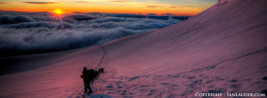
Trip: Mount Rainier - Kautz Trip Date: 06/24/2018 Trip Report: 2-day Carryover on the Kautz to the DC Cleaver. We started out gathering as much beta as possible but still had some gaps such as where exactly to find the fixed lines. Turns out one blog had it at the wrong elevation and no others described exactly where to find it. Some beta mentioned people retreating the ice steps because they found no viable way to the summit in the week before. Finally found someone who had a gps track from a guide who did it the week before so as long as weather cooperated we were good to go. The biggest planning challenge was getting our normal 45lb overnight glacier packs down to 35lbs. After buying new BD Speed 40 packs and our new hyperlight tarp shell, aluminum ice screws and a new light 60m rope, along with cutting all the creature comforts we got our pack weights where we wanted for a carryover. Drove to Longmire on Friday to pickup our permit early and stayed in Ashford. On Sat morning we were on the trail by 7am in overcast light drizzle which soon burned off. Weather showed we had a tight window between then and Sunday evening when a cold front and high winds were to move in. 7 hours later after crossing the Nisqually, going up the Fan arrived at 2pm at the lower Camp Hazard at 10,800 and found ourselves the only ones up there with the nice rock rings to ourselves. Soon after another pair, dad & daughter, joined us. Not bad only 5 people and 2 parties for the route the next morning. The Dad had tried it the same weekend before and recounted not getting any further than this point after having been blown out by 50mph winds. But at least he knew where to find the fixed lines. From the 10,800 rock rings just walk about 450ft up the scree where a climbers trail takes you right to them. He was an ice climber who lived in Ouray so we figured living at altitude and being a hard core ice climber with a party of 2 they would be fast. We discussed leaving times, we said we would be up at 1:30 and leaving hopefully by 2:30. They were planning on getting up at 3am, but they wanted to get through the climb first and asked if they could go ahead of us. No problem we said. Knowing the route was a wide chute and could accommodate multiple parties at the same time anyway. But he seemed to be thinking it was a standard ice route with only one way up. So we get up at 1:30 and are moving at 2:30 with Dad & Daughter not quite ready yet, but they catch up to us a few hundred feet later at the rock step and we let them go first since they wanted to downclimb it. Dad was making comments to himself and Daughter about how you don’t ice climb in the dark. Well, Dad, nobody made you getup early, you changed your start time to be in front of us And we had no plans to climb the ice in the dark either. Figured they would be a bit with him coaching his daughter down we just set up our rope to rap down as we padded our start time to accommodate taking time find and rapping the rock step in the dark. Which was a good idea since it wasn’t a rock scramble it was a big chuck of ice. And turns out one of the 2 handlines just drops into a free hanging drop down to a steep ice slope you have to climb back up. The rock step down, we climbed up and out to find the traverse. It was still pretty dark, just able to make out features in the distance by a hint of moonlight. But we could see Dad and Daughter who had charged straight up into a rock band with a seracs above them. All we could see was Dads headlamp flashing all over the place, as Daughters headlamp looked at him, back at us, back to him, back to us, back to him, back to us. Well, guess Dad didn’t read the route description or he was looking to put up a new route. So we continued traversing far left around the seracs to the base of the first ice step. It was easy enough climbing we wound up just soloing through it. By now we were just getting enough light to turn off headlamps and had timed it just right. Apparently Dad finally downclimbed from the rock band and followed us around to the ice step. After we soloed the first step I look over and here comes Dad with an ice axe in one hand a ski pole in the other pulling Daughter up behind him. As Daughter passes with her hand wrapped around the base of her ski pole trying to get a good stick in the ice with the tip and her ice axe flopped sideways she yells “Dad – I’m not as comfortable on the technical stuff as you – slow down”. Dad yells back “This is not technical”. And off they went. Now that we had the route to ourselves we set up our plan which was to get Philip credit for an intermediate ice climb splitting it into a multi-pitch with a lead swap. So I setup a picket anchor, and with our single 60m rope split it in half. Philip lead up the 30m placing some pro and building an ice screw and picket anchor then belayed us up. From there we figured it would take at least 2 or maybe 3 more short pitches like that so we opted to switch to simul climbing for the rest of it. I took off with the rest of the pickets and ice screws and placed a couple pickets, then a few screws and finally topped out at the 12,000ft mark placing the final picket. From there we soon were in the sun and it wasn’t too difficult route finding working our way around crevasses. Up to Wapowety Cleaver at 13,100, then up to the left around the seracs which put us out on the side of the Saddle at 14,000 then to the summit rim at 14,400 about 11:30am. By now only skiers were hanging out on the crater rim waiting for snow to soften up on the Emmons. All the climbers had long left the summit to get down before things starting softening up and potential rockfall and slides. So we had the DC Cleaver route all to ourselves as well. Snow was getting soft on the way down and there were some rock fall areas that had a lot of recent slide and rock through them throughout the day that we moved through quickly. Made it back to Paradise just an hour and a half past our estimate (which was pretty much a wash because we had stopped to relax at Camp Muir for almost an hour). Kautz-6-24-2018.gpx Gear Notes: single 60m 7.5 rope, standard glacier gear, 1 technical tool (bd venom) and 1 ice tool each, 6 screws (only used 4), 4 pickets. Approach Notes: Easy crossing of the Nisqually, up the Fan, running water at the Upper Castle. Also found a trickle of running water a couple hundred feet up from 10,800 Camp Hazard. The Rock Step is covered in block of ice. 1st Ice Step is more of a walk up, 2nd Ice Step had a good pitch of ice that we used a few screws on.
-
I've got a track from our climb of the Kautz yesterday. Not sure if you were up there. We did see a party of 3 below us when we were up above the ice steps. Kautz-6-24-2018.gpx
-
Thanks, that was a fun weekend that kept us on our toes.
-
Trip: Mount Redoubt - South Face Date: 8/5/2017 Trip Report: Mt Redoubt - 8/3 - 8/6 The 4 of us were planning on Redoubt and Easy Mox initially. With the smoke from the forest fires and heat wave we shortened up the trip to just do Redoubt. Being our 2nd trip into the area we knew the drill getting up there. All the trip beta regarding crossing the border talks about just "sneaking" in and not dealing with getting permits. This time I decided to just check and see what was involved ahead of time instead of going by all the years of trip reports with varying degrees of "don't ask/don't tell". After calling the Seattle border patrol field office and leaving a message I never got a call back. Later I called the Peach Arch border patrol office and got a lady in the billing department who transferred me to some young sounding guy who was an agent. The agent had no clue how to deal with a trail border crossing and transferred me to a supervisor. This older guy didn't seem to care or really know. I think he was just winging his answer. He said nobody would bother some hikers and when crossing the border at a trail all you have to do is check into the nearest official border crossing. Since this was an out and back and we were already doing an official border crossing he said at most we could just declare that we had crossed on our way back home. This doesn't exactly match up with the sign on the trail register at the border that says you need to get permission first. I'll just leave it at that. Instead of a 4-day trip hiking in the heat of the day we shortened up the trip to car camp on Day 1 at the trailhead and get an early start on Day 2. This worked out great. No need to take an extra day off to drive up to Sedro Wooley to get the permit. We got the camping permit on the drive up on Day 1 leaving Seattle around 1:30pm. Got across the border at Sumas and had an early dinner at TractorGrease (highly recommended, live music and great food). Knowing how bad the road all the way to the end of the "drivable" road was from last trip and having a Toyota FJ decided to drive all the way to the end of the road this time which was an adventure but it handled the rocky road all the way and saved us an extra mile. Up at 4:30am on Day 2 and hiking by 5:30. It took us 7.5 hours to get to Lake Ouzel. It was pretty straight forward other than running across a bear just over the border. And members of the party getting stung by hornets on occasion. And losing the trail a couple times. And going a bit too high in the slide alder just before final push up to the lake. Had plenty of time to relax for the rest of the day. Saw a party of 2 from Canada come in at evening who were heading off to Spickard or Silver Lake and didn't see them again. Up at 4:30am on Day 3 and hiking by 5:30 again for our summit day. Walked over to the river crossing from camp and it was looking pretty high water and not easy to cross without wading. So we walked around the lake instead which added about a half hour to the day crossing a few smaller streams along the way. Navigated up the slabs easily and to the base of the Redoubt glacier. Roped up and pretty much when straight up. I recall beta saying its just got lots of small cracks, not heavily crevassed. Not sure if they all missed the gaping cavern of a crevasse we passed that looked to be about a hundred feet deep. Straight across the glacier to the low notch. This was a straight forward few moves up and over. Back on snow again and we passed the first snow gulley and headed to the next one. It had taken us maybe 4 hours to get this far. From here things got steeper and slower. 1300ft up and all steep snow and loose rock. After some easy rock scrambling and the first short gulley got on a snow finger that took us three quarters of the way up. Here one of our party tapped out being uncomfortable with the steep snow and we were okay leaving them to enjoy the day on the rocks to the side of the snow finger till our return which was a good idea as it only got steeper and harder. A few hundred more feet up we hit the crux of the day. The gulley narrowed and the snow finger had melted out a moat on both sides with top being just a couple inches across of soft snow which couldn't be crossed. I dropped into the left side of the moat and went up a bit. It was about 8ft high and overhung a bit with no good features on the rock and snow too soft to hold an ice pick. Wasn't able easily even get off the ground. Got out of the left moat and went over to the right moat which was about 8ft high as well but just couple feet wide with some nice features on the rock. Was able to chimney against the rock kicking foot holds into the snow and pushing up to the lip. The snow was soft enough on top to get the full shaft of the axe in for a self belay to haul up on and regain the snow finger where it got wider. Got all 3 of up that with some coaching and encouragement. We'd figure out how to get down it later. From there another 100ft up to the last bit of snow patch and dropped our ice gear. We figured out the gulleys and ramps from the beta pretty well and made our way up to the rap station with the cannon hole in sight. One person led up just clipping the cannon hole slings and placing 2 cams and made short work of the rock pitch in about 5 minutes. All 3 of us were on the summit within 7 hours of starting. Spent about 20 minutes on the summit then started down doing 3 rappels which got us down all the hardest of the scrambly bits and made our way back to the last patch of snow. From here we had to figure out how to best get down the moat. We figured the distance was probably reachable from here with a twin 37m rappel. Not wanting to leave gear the last snow patch made a perfect bollard using some rocks to pad the edges to not get the rope stuck. And it worked perfectly, our first member down reached the bottom of the larger left side moat with about a foot of rope to spare. Got everyone down and pulled the ropes. Here is where our big time suck happened that took us from a possible 13 hour climb day to a 16 hour climb day. The steep snow was soft on the top to the point it wasn't soft enough for plunge stepping but soft enough it would just clog up the crampons and you would slide out. I slowly side stepped down but the others were too uncomfortable with that and decided to setup another rappel off another snow bollard. This added a considerable amount of time and since they didn't get the edges padded they got the rope stuck and probably spent an hour just getting down one short pitch that could have been slowly downclimbed face in faster. Once we got everyone off the steep snow a couple were uncomfortable with the steep loose rock scrambling which took considerable amount of time. We had left the summit around 1:30pm and didn't get off the base of the steep section till around 6:30pm. Once down we went as fast as possible and got off the slabs at the lake around 9pm just as it got dark and had to turn headlamps on. Back to the tents by 9:30 making it a 16 hour round trip from camp. Day 4 we slept in and left camp around 8:30am and took 6 hours to get back to the cars. Met another party of 3 at the waterfall coming up to do all the peaks in a 5 day outing. Back at the truck made the descent down the rocky road and passed a few cars a mile or so later. And just some ways before the exit of that branch of road up comes a middle aged guy in a beater atv smoking a cigarette and wearing a white t-shirt and motorcycle helmet driving up toward the trailhead. He looked annoyed he had to get off the road to let us by. Not sure what he was going up there for. Nothing that way except for other climbers cars and a long trail to the border. In the end a successful trip with 3 of 4 of the party reaching the summit. All 4 making it out safe and sound. The smoke from the forest fires made for a surreal effect and helped keep the temperature down from the heat wave that was predicted. Bugs were pretty annoying all along the hike but not bad at camp and only 4 or 5 hornet stings between us. Gear Notes: 2 small cams and a couple slings. Approach Notes: Only issue was with a section of snow finger that had melted out to the point of having to climb into and back out of a moat.
-
7/1/16-7/4/16 4 day 4th of July trip to Spickard and Redoubt. Turned into a 3-day trip with just Spickard. I've read that you can get a permit by just calling in the day before to the Marblemount Ranger Station. And the trail register when you get to the trailhead start at the US border says the same. But when I called the day before they said we had to show up in person at Sedro Woolley to get the permit. So I wound up taking off early on Thur before the trip and driving there to get the permit. The rangers at Sedro Woolley didn't know what I was talking about and had to call somewhere else. Finally, someone somewhere else put a permit into the system and they printed it out. Everyone else we've been hearing from who've done Spickard and Redoubt haven't even bothered with permits. Since you are driving into Canada then hiking back across the border into the US you are supposed to get permission from customs (you don't find that out till you have actually hiked an hour or so into the climb to the US border crossing). The rangers didn't care that we were crossing back into the US and didn't say anything about getting customs permission. Wouldn't surprise me if nobody has ever bothered to do so. Weather forecast was looking marginal as we met at the park and ride at 5:30am and we considered if we should cancel or not. Decided to make a go at it as we thought we would have a 50/50 chance at good weather. Took us 5 hours (with a 20min border crossing stop, a Subway stop and gas stop) to get parked at the trailhead. We stopped at the main parking spot where the road splits off and there is just enough room to turn around and park 2 vehicles as one couldn't make it up the rest of the way that requires a high clearance vehicle. Good thing too as there was a fallen tree across the trail halfway to the end of the drivable road and another party of 2 ahead of us parked on the side of the road up there. When we returned though a road crew had come through and cut through the downed tree so you can make it now all the way to the end of the drivable road. With all the branches hanging over that last stretch of road I'm going to have to get the scratches buffed out. Starting off we had a slight bit of rain but that didn't last long. We also went a little too far down the trail and wound up doing some bushwhacking to get uphill about 150ft to the main trail. There a couple paths up from the trail you first start hiking in on to get to the overgrown old road trail. If you see some pink flagging take that path, or there's another path further up in a flat rocky area of the trail you might spot a tiny cairn, take a left there and bushwhack a bit to hit a trail going uphill that intersects the upper trail. If you are on an old abandoned road that's a bit overgrown heading toward the US border you are on the right track. Old beta we read said something about the trail on the US side being much better. Not so anymore. Once you get to the US side it doesn't look like there's been any trail maintenance done in years. From the trail register and the summit register on Spickard we only saw one other party of 2 that had signed anything since Sept last year. That explained how much the overgrowth had come in and the bushwhacking that was to follow. Lots of blowdowns to navigate over, under and around and you have to keep picking up the trail, easy to lose it in places. Also the trail was pretty overgrown in places requiring full body bushwhacking to plow through. And usually involved nettles and devils club. We looked like we had been through a catfight by the end and stinging from head to toe. Crossing the first creek involved walking along a branch over the water then getting up the waterfall was pretty straightforward, the rope handline and anchor looked in good shape, a rain shell or poncho helps keep you dry from the spray. On the descent we did setup a rappel considering how slick the rock was. The rest of the route was pretty straightforward. Once you get to the final approach to the lake you can take a couple paths. Either hug the creek and go up the boulders or another path can take you higher up which involves a lot more bushwhacking. Take the lower path, but either will get you there. It took us 9 hours from car to camp. We decided to sleep in and do the easier Spickard the next morning. Got rolling around 9am the next morning and took the late season route up a snow field and traversed over and up the other side. The soft snow took some work kicking steps all the way up but it's a straight forward walk up. Took a lunch break at the top of the snowfields before popping over the col. One of the party got pretty excited seeing a large wolf pack running around the slopes below us - sorry man, those are just goats. Traversed over the other side to the final snowfield and went up, then had to move further right to the top right of the snowfield to gain the rock for the scramble. We had taken up a rope, pickets and some light gear after reading about parties setting up a handline for an exposed section. We never found any need or place for a handline, it was a straight up easy rock scramble to the summit. If the snow was hard and arresting would be difficult pickets may help in a couple spots where its steeper, but except for the very last section of the last snowfield before the rocks the runout was safe. We didn't use any and didn't rope up. There were a few places on the way up with running water including up the final summit blocks if you need to refill. After returning to camp we decided to get up at 4:30am for a 6am start for Redoubt. But when we got up it was raining, windy and socked in. Slept in a couple more hours and the rain had stopped but the summits were still socked in and pretty windy so we decided to break camp and get out a day early. We figured the return trip would go faster but it still took us 8.5 hours out. We made better time in the flats but the bushwhacking, blowdowns and setting up a rappel down the wet rock at the falls took some time. Took us only 4 hours return trip home (1 stop for dinner and no wait at the border crossing). The 'day use only' marked road is still pothole hell. FYI - the locals were driving on the theory that if you go fast enough you will float above the potholes. One caught some air on a pothole passing one of our vehicles and landed off the road close to the dropoff into the lake. On the way out hit the TractorGrease, the first restaurant you run into on the lake road out coming out. Awesome food, even if we hadn't spent 3 days in the alpine. Highly recommended.
-
[TR] The Brothers - South Couloir 5/7/2016
Ian Lauder replied to cgolden123's topic in Olympic Peninsula
Yea, we had 2 pickets, not a ton of them. And left them at camp. But we did need crampons since it was frozen solid the last 700+ feet. We did a 5am start (from the 3000ft camp). -
Trip: Ruth Peak & Icy Peak - Ruth/Icy Traverse Date: 8/23/2014 Trip Report: We climbed Ruth/Icy Aug 23-24. Approach was in good shape and the gulley at Hannegan Pass wasn't difficult. Watch for knocking rocks down here. There was only about 600 vertical feet of gain roped up on Ruth which was a straight forward climb up. At the rock summit go to the left of the summit block to find the climbers trail vs trying to go up it directly which would be a more difficult loose rock scramble. Descended Ruth's West ridge (some parties did descend the south ridge which is just slightly more exposed, both routes work). Once at the camp area right at the head of the gulley we found plenty of running water and scouted out the descent route down the gulley. There are cairns marking the path more or less, you can take multiple paths down but stay out of the main gulley, go down just skiers left of the gully. We left at first light around 5:15am. Also make sure to find the paths down to the Ruth/Icy saddle which are to the left. If you follow a path to the right it can cliff out. Once on the saddle we worked out way along the boulder fields to the bottom of the glacier and roped up. Ascended the standard route (staying left near the ridge) and to the right of the bergschrund, then an ascending traverse right and zigzagged between a couple crevasses to reach the notch. Unroped at the notch and followed the climbers trail to the main gulley on the north face of Icy. With another party just coming down we used their rappel line to get a quick belay up to speed our ascent and setup our own handline. Got everyone up to the top by 11am and got back to camp by 2pm. With some clouds and potential rain coming in we started out right away but luckily missed a rainshower that headed up the pass ahead of us and were back at the cars by 9:30pm. Route was in great shape. Gear Notes: Standard glacier travel gear one 60m or two 40m ropes to rappel the Icy summit gully Icy gulley can be scrambled, there are also a few spots to place some pro so a light rack may be used, take gear to rappel back down Approach Notes: Easy approach, clear trails all the way to base of Ruth, running water at the camp area just ahead of the Ruth/Icy gulley. Also a few bivy spots right at the top of Ruth as well as just down the Ruth/Icy gulley. Gulley up to Ruth from Hannegan Pass was a little slippery (would be harder if it was wet and muddy).
-
Trip: Mount Shuksan - Sulphide Glacier / South East Rib Date: 8/10/2014 Trip Report: Our party of 2 attempted our first serious solo alpine summit and multi-pitch rock climb Aug 9/10 of Mount Shuksan via the Sulphide Glacier and climbing the South East Rib. We got our permits a day ahead of time, it paid to go a day early to get permits on Friday so we would have time to get up higher to a high camp away from the weekend crowds. We started up around 8:30am and got to the lower camps (3500+ gain) in just under 4 hours). Took a long lunch break and refilled water just below the lower camps at the only place we found running water (at about 6000ft). Stopped for a break at one of the worlds most scenic toilets looking out over Mount Baker and chatted with a guided group camped out there. We roped up here at around 6400ft and climbed up to around 7800 to make our high camp just across the flats from the summit block. We figured this would give us a head start on everyone else in the morning and would make for an easier summit day. Camping out at the high camp turned out to be incredible sunset, moonrise and sunrise views, especially with the glow coming from the haze of the (unfortunate) forest fires. We were treated to an golden sunset with a full moon (almost super moon) rising at the same time. We got up around 4am and being up well ahead of the weekend crowds took our time getting ready and were off to the summit around 5am. Just as we were approaching the top of Hells Highway two groups of 4 appeared from the Fisher Chimney route. They were all heading to the central gully luckily. When we looked back, over the horizon came a freight train of about 15 climbers (one group of 11 and looked like a party of 4) - all heading to the central gully as well. We got to the rock island just below the rock climb and dropped a pack and geared up for the rock climb waiting until the sun had a little time to warm up the rocks. The approach to the South East Rib was pretty straight forward but a bit trickier to get over up the chockstone in climbing boots so I switched to rock shoes which made it an easy walk up. Not having ever been to Shuksan or able to see pics of the whole rib and being the only ones there we did get off route for a moment and wound up near the gully so had to hop back up onto the rib (which was probably a 5.8 move from what someone else there said). It was easy to get off route seeing footprints in the dirt heading that direction (and ran into someone else there who had done the same thing their first time). Basically stay in the sun on the rib the whole way. We did it in 4 pitches (not counting the short hop up to get back on track). You can run out sections on scramble class rock no problem, most of the time there were large horns and blocks to throw slings over. The few 5.4 moves along the way sometimes were easy to protect otherwise just find the hand and finger holds and go up a few feet to find more lower 5th class climbing. Pretty straightforward. Due to so many people heading to the central gully we were concerned there would be a huge clusterf#@k getting down. And there was but thankfully we missed the bulk of it. Met some cool guys on the summit who had done an insane approach from the Nooksack/Price approach and on their way out the Fisher Chimneys. That was impressive to read about later. We did listen to constant calls of "rock" crashing down the central gully as we were heading up the rib and while we were waiting to rap down which was disconcerting. I wouldn't want to be in the middle of the gulley further down with anyone up above. There was a huge cluster of people at the last rap station and the two guys ahead of us did one rap and then downclimbed the rest of the gulley to not get stuck behind the large group. We waited for them to get out of the gully before starting our descent. We did 4 rappels and used shoulder slings to feed out the rope instead of throwing ropes down to help avoid rock fall. Most of the rap route was clean but there are sections where there is a bunch of loose rock, so gingerly took our time getting down and avoided knocking anything down. By the time we got to the last rap station the last person of the large group rapped off and we got off without having to deal with the bottleneck. Huffing full packs all the way up to 7800ft also meant that much extra hiking out but only took half an hour to get all the way down to the lower camp and was an easy walk out. All in all the climb went great, weather cooperated and were able to mostly avoid issues with the crowded gulley. Gear Notes: standard alpine and glacier travel gear for rock climbing the rib - used one small nut and a few small cam placements (cams probably not even necessary but were nice to have a handful), 8-10 double slings. 60m glacier rope. Approach Notes: Trail crews had cut through all of the blowdowns on the trail within the week or two before our trip. Made for a more pleasant approach. Snow was in great conditions all the way to our high camp at 7900 feet.
-
[TR] North Cascades - Nooksack Tower / Price Glacier 8/5/2014
Ian Lauder replied to dave schultz's topic in North Cascades
Likewise, that was a great summit pic you took of us. Feel free to snag them off my FB page. I can send full size ones as well. Now that I think about it, that person leading the group of 11 up Shuksan this weekend caused us a safety issue months ago on another climb. On a great weather day on a popular rock on a 3-day holiday weekend. Our first outing on our own learning trad leading on Midway in Leavenworth we started up early on cold rock, hands numb, they show up after us and while we are waiting for the rock and our hands to warm up a bit and we had a new leader on her way up first time after recovering from a broken wrist in a fall last year, he got her flustered with his badgering wanting a couple routes all day for his group of students and she opted out. Left us with 3 on the top of the 1st pitch and we had to bail out. -
[TR] North Cascades - Nooksack Tower / Price Glacier 8/5/2014
Ian Lauder replied to dave schultz's topic in North Cascades
Hey Dave - my wife and I were the twosome on Shuksan. Got a few pics of you (links below). By the time we waited for you two to get down the gulley so we didn't knock anything down the party of 11 was thinning out. By the time we got to the rap station the last of them just pitched off when we got there. Thanks for tapping that nut out Mt Shuksan pics Mt Shuksan pics Mt Shuksan pics
