

bedellympian
-
Posts
431 -
Joined
-
Last visited
-
Days Won
43
Content Type
Profiles
Forums
Events
Everything posted by bedellympian
-
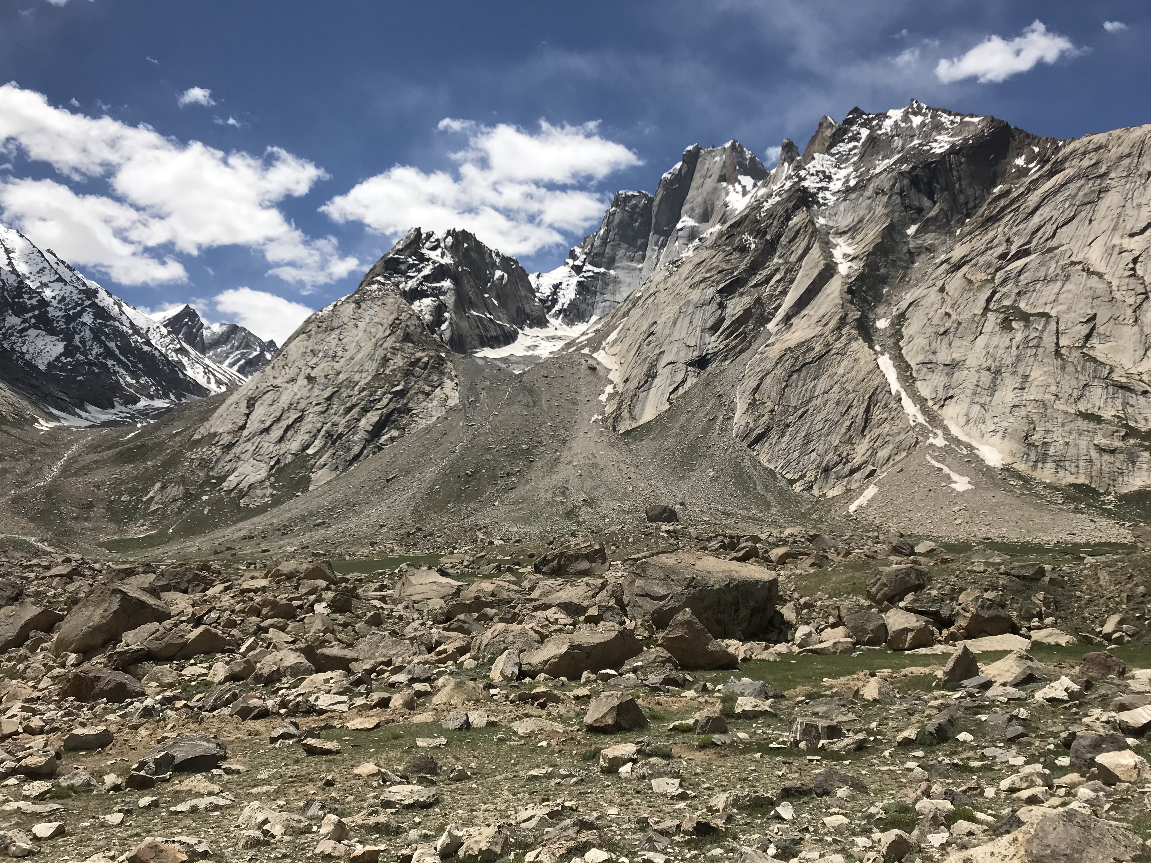
Trip: South Sister - Prouty Glacier Date: 9/2/2013 Trip Report: My friend Kolby (trail name Condor) is heavily involved in the PCT thru-hiking community and regularly lets thru hikers stay at his house in Bend. At 11:20 on Monday morning I got the following text from him: "A thru hiker staying with us attempted to go down the north side of South Sister yesterday w/o any climbing gear. He found himself in a position where, if he lost his grip, he would fall. He saved himself by removing his backpack, which fell down the mountain. He was able to get off the mountain safely but lost all his gear and hitched back to bend with only what he was wearing (which didn't include a shirt). I'm asking if anyone has an ice ax he can borrow today to go look for his backpack on the northeastern side of South Sister." It turns out he had seen the moderate looking north ridge of South Sister on his topo map and attempted to descend it toward Middle Sister. He got off route in steep terrain and dropped his pack thinking it would land on a ledge 20 feet down and he could retrieve it. Instead the pack bounced down over a 1,000 vertical feet of choss cliffs towards the Prouty Glacier and he was unable to see where it had come to rest. After trying unsuccessfully to down climb further he climbed back over South Sister, hiked out in the dark and got a ride with other late hikers back to Bend. If I'm being honest I have to admit that I could see myself getting in a similar situation. I decided to help the poor guy out; drove him out there, hiked in. We took one look at the face and thought that it was more likely we would discover a woolly mammoth entombed in ice than the pack. None the less we worked our way up to the glacier. He had minimal running shoes and no gear so I left him on some scree and headed up the ice. It was already 5:30 at this point and I figured I would turn around at 6 so we had a chance of finding the trail in daylight. Just as I reached the top of the glacier where it meets the cliff I looked up and saw a blue and yellow blob a mere hundred feet to my left, it was 6:01. I brought the pack down to him and it was miraculously intact minus a couple broken plastic buckles. The plastic food bag inside had been pulverized and shredded but the ripstop just looked like it had been rubbed in some dust and the tent poles strapped to the outside were fine too. We hiked/jogged out by headlamp and made it back to Bend in time for a late night happy hour ...definitely the most random mountain adventure I've had but a lot of fun. Blog post with a couple pics and more details: Mountain Mischief Gear Notes: cranial choss deflector (aka helmet), ice axe and pons Approach Notes: Green Lakes Trail, traverse north of Carver Lake to west side of Prouty
-

[TR] Mt. Stuart - Complete North Ridge 8/25/2013
bedellympian replied to bedellympian's topic in Alpine Lakes
Keenan: The rap tat in my photo was next to our bivy ledge. In the dark we climbed up behind the GG a full pitch to find our bivy. I believe that if we had continued traversing from the top of the GG's OW we could have reached our same location that we did after the rap (Nelson/Potterfield don't mention a rap). From the bottom of the bivy rap it was another pitch to the notch and base of the 5.8/5.9 crack/headwall. Not sure if that is what you wanted to know? Maybe you topped out the GG? We didn't do that. Kevin: Thanks man. I was stoked to get it done and felt it was a good experience for me at this point. Maybe next time I'll do it in winter! -
[TR] Mt. Stuart - Complete North Ridge 8/25/2013
bedellympian replied to bedellympian's topic in Alpine Lakes
Although after rereading the description in the Nelson/Potterfield Guide I think that we were in the Cascadian. His description matches perfectly with the snow field and also the sandy trail in the couloir. Since the Cascadian is not actually labeled on maps its possible that it's become a matter of climber opinion which is the "real" Cascadian? Who really decides these things anyway? Fred Beckey? My main point: follow the cairns to the sandy trail and the descent is pretty easy. -
this link doesn't work
-
[TR] Mt. Stuart - Complete North Ridge 8/25/2013
bedellympian replied to bedellympian's topic in Alpine Lakes
Ah, you are probably right, we did have to hike up Ingalls Crk to reach the Long's Pass trail. I was really blown away by how much people complain but that makes much more sense. -
Trip: Mt. Stuart - Complete North Ridge Date: 8/25/2013 Trip Report: Travis Holman and I hiked in to climb the CNR on Sunday Aug 25th. It rained a bit on the approach but we were optimistic the weather would improve the next day, or at least the day after that. It did not. We bivied near the base of the ridge and started climbing Monday morning with the intention of summiting and starting the descent that day. The day started clear but soon socked in. We had some route finding difficulties. It rained a bit but not too bad. We got to the Great Gendarme around 7:30pm. I pulled on some gear to speed stuff up. It started snowing while I was on the OW pitch. We found a bivy ledge just past the Gendarme. The next morning the visibility was even worse. We eventually found the summit and the descent cairns. Maybe we are just used to Oregon choss and scree but the Cascadian seemed really easy and we were both puzzled as to why people complain about it so much. The cairns lead right into it and some loose talus up high quickly resolves to a well defined trail through the scree. We both thought that climbing South Sister via the trail on its south side is just as bad or worse. I would also like to thank those climbers who choose to use brand-new, light-weight biners for retreating from this route. I have 5 nice new biners and Travis has quite a few also! Here is my blog post with more pics and details... Mountain Mischief Gear Notes: single rack from small to #4 camalot, lots of alpine draws, 60m rope, a rain fly for bivies, no pons or axes were taken and we didn't regret that decision at all Approach Notes: Ingalls to Goat Pass, descent via Cascadian and Long's Pass bottom of n ridge sherpa peak sherpa and ice cliff glaciers rap tat near our bivy, which we used to get back on route me on the summit in stellar conditions
-
Nice work! I climbed the Grand via Direct Exum last year. It took us over 21 hours car-car but was a total blast. I wouldn't be worried about your altitude response. I can't remember how many times I've been over 13,000 ft now but I respond differently every time. I ran South Sister (10k') a few days before the Grand and felt terrible (probably a little dehydrated which seems to be key for me at altitude). Three days later I felt awesome on the Grand and had no problems despite being much higher.
-
Thanks for the help guys! Guess its time to grab my socks and go to the outdoor store.
-
yippe kai yay, hallelujah, etc etc etc that's great timing!
-
Thanks for all the input guys. Scared: My PGs were 45s. Recently tried Spantiks and think I could wear a 43 comfortably. I was under the impression that 6000s and Spantiks were comparable in warmth and use. Is this not correct? Now leaning toward a single boot, I guess, as it seems that would be more useful for me. I guess I can always wear vapor barrier socks and/or carry newspaper to keep the boot dry on multi-days. I have a wide fore foot but otherwise its skinny with a high arch... not really sure if this lends towards Scarpa or Sportiva more, or some other brand.
-
Mountain Mischief I've linked it on a few TRs but figured I'd post it here too. Trying tto get a good mix between some goofing non-serious stuff, and TRs. Please feel free to provide feedback! Thanks! Sam
-
I'm already climbing at WA pass. I was going to finish the trip with some stuff in Boston Basin so I need an alternative to that. By alpine I mean something that isn't roadside.
-
Hey guys, Just wanted to say thanks for posting. The input was super helpful. I ended up trying to climb a peak in the Delta Range (you might have seen the TR on here about a month ago). Other than that I got busy and didn't do too much climbing. Looks like I'll be back next year in August for a bit, but hopefully one of these years I'll make it in April or May and have some real fun!
-
Yowsers! Guess I need a backup Anyone know of a good Alpine route on the E side of 20? Mt. Goode NE Buttress via PCT from rainy pass? Something further South?
-
Thanks for the input Dave! I had heard that the new PG is thinner and colder. I also read the Spantik review on the cc blog which compared it to Scarpa Phantom series and said the less rockered toe on the Phantom is a downer for approaches. Since you own a pair what is your experience? Do you have the new orange PGs or the older red model? Anyone have experience climbing WI5 or M6 in Spantiks?
-
Just sold a pair of Scarpa Phantom Guides (older red model) because they were really too big for my feet. Need a mountaineering boot but not sure what to get. I have the money from selling the PGs and thought about getting Spantiks... overkill for most stuff I know, but they feel really good on my feet, climb well, and they have the removable liners so I can use them on multi day winter trips and be fine. Right now I have approach shoes and TLT5 ski boots so summer alpine rock routes and moderate winter routes with skiing are covered. I live in Oregon so the gnarliest routes I will get on with these boots will be hard Hood routes in winter. That said I have family in Alaska and visit most years so I will have the opportunity to climb up there in summer. Some of the routes I'd like to get on over the next couple years for which I will probably use these boots: March Maddness, Illumination Rock (WI4/5) North Face Right Gully, Mount Hood (IV, WI3) Arachnophobia, Mount Hood (IV, 5.9 AI4) Yocum Ridge, Mount Hood (IV, AI3, 60deg) North Ridge, Mount Baker (III+, 70+deg) Triple Couloirs, Dragontail Peak (III-IV, 5.8, 50+deg) Liberty Ridge, Mount Rainier (V, AI3, 50deg) North Face of North Peak, Mount Index (V, 5.7, steep mixed terrain) I know people probably have multiple boots but I'd like to stick with one good pair for now. Thoughts? Suggestions?
-
That was a pretty ridiculous video, looks like a complete load of media hype BS. Even so, there are so many derogatory comments on the youtube page I almost feel sorry for the guy. His ego must be completely crushed from a 1,000ft ground fall.
-
I was planning a trip up to do WA pass and Boston Basin climbs (from Bend). Probably come up the East side. Whats the easiest way from Mazama to Boston if 20 is closed? Steven's Pass? Should I just go to the Stuart Range and skip Boston? What's the take from North Cascades vets?
-
[TR] Incredible Hulk - Sunspot Dihedral, IV 11b 8/3/2013
bedellympian replied to TeleRoss's topic in California
Sierra Granite! Awesome! -
Trip: Smith Rock, Monkey Face - W Face Variation Date: 8/10/2013 Trip Report: John F and I climbed Monkey Face via W Face variation on Saturday. There was no one on the route. I guess that was because the forecast called for rain with a chance of thunder storms. It did rain and it did thunder but luckily the weather cleared up for a couple hours and we made the top. We took no aid gear or ascenders for the bolt ladder. We used a sling each for occasional feet and yarded on draws. With a good belayer this works well. Just make sure you think through your system first and are on the same page. We both cleared this pitch in less than 30 minutes. Heads up: at least two bolts are loose and look like they could go, we felt this added to the excitement but others may feel differently. Blog w/ pics, etc. http://mountainmischief.blogspot.com/2013/08/monkey-face-via-west-face-variation.html Gear Notes: single rack, lots of draws, rap line and regular rope Approach Notes: Asterisks Pass
-
Trip: Three Fingered Jack - South Ridge Date: 8/8/2013 Trip Report: Travis Holman and I climbed 3FJ Thursday morning. It was a surprisingly short approach and climb. There is much less 5th class than the slightly shorter neighbor, Mt. Washington, but the rock is much worse. Now that I have ticked it, I doubt I could be convinced to return unless it was frozen solid. There appeared to be good steep couloirs on both the E and W faces that might prove fun in winter. Blog post: http://mountainmischief.blogspot.com/2013/08/3fj.html Gear Notes: slings & nuts (I think we placed 6 or 7 pieces of pro on the whole thing) Approach Notes: PCT north from Santiam Pass
-
[TR] Desperate Country: Seven Days On The Fence
bedellympian replied to JensHolsten's topic in North Cascades
Wow, that is inspiring and awesome. Way to go for it and get a ton done in one week! -
Trip: White Princess - Delta Range - W Ridge/M'ladies Glacier Date: 7/3/2013 Trip Report: My friend Eric and I reached a high point somewhere between 9000 and 8500 ft on the W Ridge of White Princess. We encountered rain, hail, snow, wind and low visibility conditions. We hiked in 12+ miles from the road on the Castner Glacier on July 2nd (7hrs). We camped on the glacier around 5,000ft. July 3rd we climbed to our highpoint. The route was mostly scree and talus with 1500ft of snow and ice between 40 and 50 deg. We returned to camp in 9hrs and hiked back out the way we had came in 5hrs. more details and photos... Mountain Mischief Gear Notes: 3 short axes and pons, a short rope and some pickets could have made the route to the summit more reasonable... its alaska so bring clothing for all conditions Approach Notes: Richardson Highway bridge over Castner River, follow river to glacier, follow glacier to 3 way branch (7.5 mile straight line), south/Milady branch to base of W Ridge (3 mile straight line)
-
I'm in Fairbanks through July 22nd (trip to Anchorage for about a week in early July). If anyone wants a crag partner for the interior or is interested in doing something more alpine let me know. Lead 5.10 trad/5.11 sport. Comfortable in mountains, limited glacier travel experience (I'm from Oregon).
-
So I'm in Alaska for about a month visiting friends and family (mainly Fairbanks but I'll be in Anchorage for a week or more). I don't have a partner yet (anyone interested?) but I am interested in climbing something while I'm here. Given my time and money I want something that I can do relatively quickly, without flying in. I am also relatively new to technical alpine climbing so it should probably be 5.9/AI3 or lower. I was thinking of something in the Chugach but maybe there are better objectives else where. Any ideas? My window is July 6-20 but I can only take 3-5 days total. Thanks!