


Holk
-
Posts
96 -
Joined
-
Last visited
Content Type
Profiles
Forums
Events
Posts posted by Holk
-
-
My only concern is the drone ...
To clarify my last remark, I have never been in favor of requiring permits for photography on USFS land, even for commercial photography. I think we should regulate ourselves ... When we don't regulate ourselves, even if out of ignorance, then we need regulations.
I agree with you wholeheartedly.
-
Some beautiful video shots. The credits imply that an aerial drone was used in a wilderness area. I think this is crossing the line. They certainly didn't need to use a drone, and it doesn't appear they did, to film inside the cave. I'm guessing it was used for the view looking down on Sandy Glacier.
Until now I have been opposed to regulation of photography on public lands, something the USFS in currently considering. Now I am starting to change my mind.
PCG, you might send the folks making the film a note regarding your concerns. You bring up several valid concerns, the drone usage in wilderness and perhaps commercial photography without a permit on public land.
Otherwise the photography was very nice. The story was good as well.
I second ScaredSilly on bringing up your concerns with the company. They are a great outfit and very nice people, so I'm sure they're not looking to break any rules intentionally.
I don't know all of the specifics about regulations regarding drones and where new technology may or may not find loopholes for such regulations.
However, in regards to your second concern, from what I can tell their video has not been used commercially, except for attaching their name to it. If that is the case they're breaking no greater rule than I am, being a part-time photographer, by having taking pictures for personal use and publishing a few on my site. But then again, maybe I am supposed to have a permit for such an act. I've read through the regulations before, but they can be nearly as dense as Leviticus.
-
Trip: Mount Saint Helens - Worm Flows
Date: 11/8/2014
Trip Report:
I went up Saint Helens a week back and knew there wouldn't be much in the way of any snow, but it was as my climbing partner requested. Alas! The split board remains in my closet. It was a beautiful climb up and nearly to ourselves. Marble Mountain's parking lot was empty at 3am and we didn't see or hear anyone until 7:00am on the summit. The climb down worm flows was brutal on my knees and I think that'll be it for me until the snows increase. Pray for more snow people!
More photos and a better write up on my blog: http://holkphoto.com/mount-saint-helens/


I don't know who these climbers were, but they had de-poned to glissade down and were having a rightfully difficult time getting to a good path. I was glad to see they had a decent descent. If you guys are on here PM me and I'll send you a few more shots.
Gear Notes:
Pons and axe pre sunrise, otherwise unnecessary.
Approach Notes:
Marble Mountain / Worm Flows
-
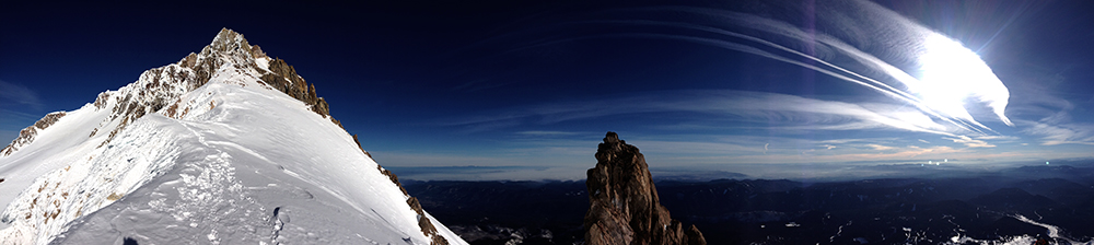
Trip: Mount Hood - McNeil Point
Date: 10/18/2014
Trip Report:
In an attempt to recapture a shot of the Sandy Headwall's upper face from many years ago, I went up McNeil Point last Saturday with high hopes of there being fresh snow on the summit.
To my satisfaction there was indeed a good dusting of snow from 10,000 feet and up. During our ascent we ran into the production crew of Uncage The Soul and had a brief but good chat with them. They were on their way toward Snow Dragon and Pure Imagination and had more gear than I could ever hope to own. It looked heavy, to say the least. Keep a lookout for whatever it is they're planning to produce.
The remainder of the trip was extremely pleasant as we sat on the arête between the Glisan and Sandy glaciers and below Cathedral Ridge. Clouds enveloped us from time to time, but typically they rolled and curled on either edge of the knife ridge and we remained graced by the sun.
More photos here on my blog: http://holkphoto.com/mount-hoods-seasonal-forecast/


Gear Notes:
Canon 7D, 70-200mm 4.0-5.6, Manfrotto Tripod
Approach Notes:
Top Spur TH
-
Wow, your photos are excellent, they really "pop", must be a lot of work?
Thanks Wayne, but bd2510 is mostly correct about the process. It really doesn't take too long, but given that all of the images were taken using an iPhone 4s (which is more the reason you see noise in the images than the editing) I figured a little sprucing was in order. I wasn't feeling the DSLR on this one.
... That makes three ascents of that route that day, great conditionsI take it you were one of two parties ahead of us then?
-
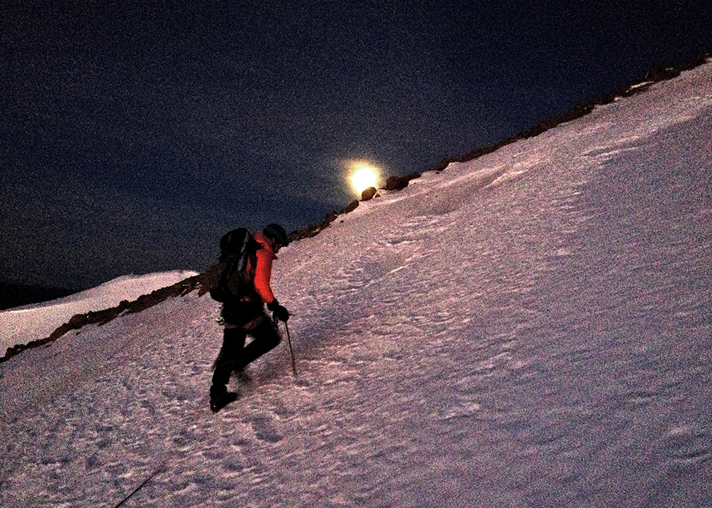
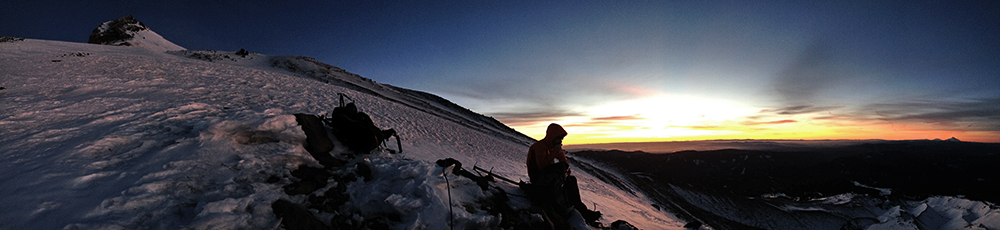
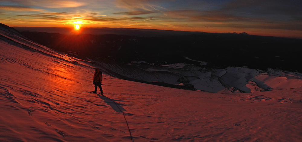
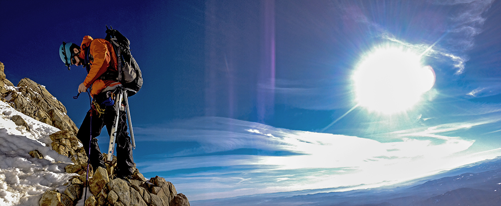
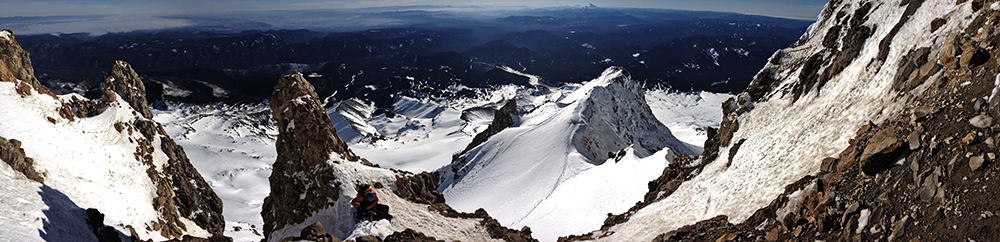
Trip: Mount Hood - Wy'East
Date: 1/17/2014
Trip Report:
The rain was blowing sideways outside as though there were a tropical storm a'brewing and while it impacted my bedroom window I had awoken. The time read 1:04am from my bedroom clock in Portland. Suddenly I was filled with all sorts of worry and anxiety since as of six hours prior I had made plans to meet with my climbing partner Matt Pennock in the town of Sandy at ... yep, 1:00am. Although the alarm had never gone off I had to give my internal clock some credit for jolting me back to reality, for you see there never was any rain outside and all that turbulent weather, real as it seemed, had been completely fictitious. I'm remain curious as to the psychology behind this?
Lucky for me I not only had everything pre-packed, but Matt was also extremely gracious in waiting the extra hour and some change. After driving through the commonly thick fog and into clear skies I was happy to finally rendezvous with my partner. Even though we were a few hours behind schedule we made the most of our time. By 4am we were dressed, registered, and on the mountain.
The rest of the story is told throughout the pictures. We simuled where we could and short-roped where post holing occurred. Overall the conditions were nearly perfect, although perhaps a little too warm. I will add one last funny note that the only climbing party ahead of us (and there were only four climbing parties in total that day) was a pair who had chosen to climb Wy'East as well. Watching their headlamps reach the crater rim just as we reached the glacier was neat and had we been on time I'm sure we would've all climbed close together.
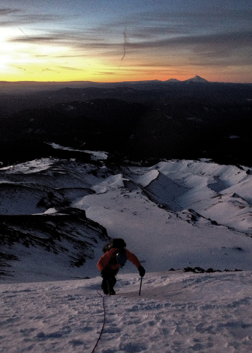
Matt exiting the eastern gully from the White River Glacier's lower crossing.
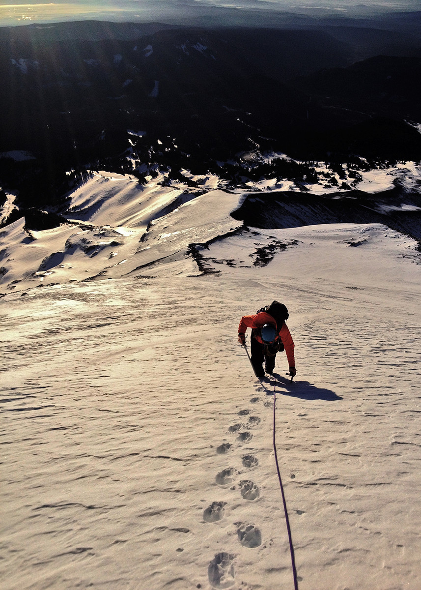
We short roped our way up the initial ramp toward the crater rim.
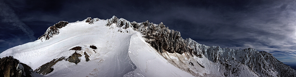
Our first view into the crater of two climbers ascending the old chute. In total only four parties registered to summit this day.
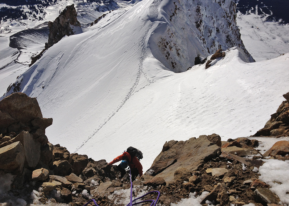
An easy rock step, however, with the amount of exposure present we opted to protect and belay one another here.
We set up another belay across this narrow portion of the climb as well. We then simul climbed the remainder of the route to the summit ridge.
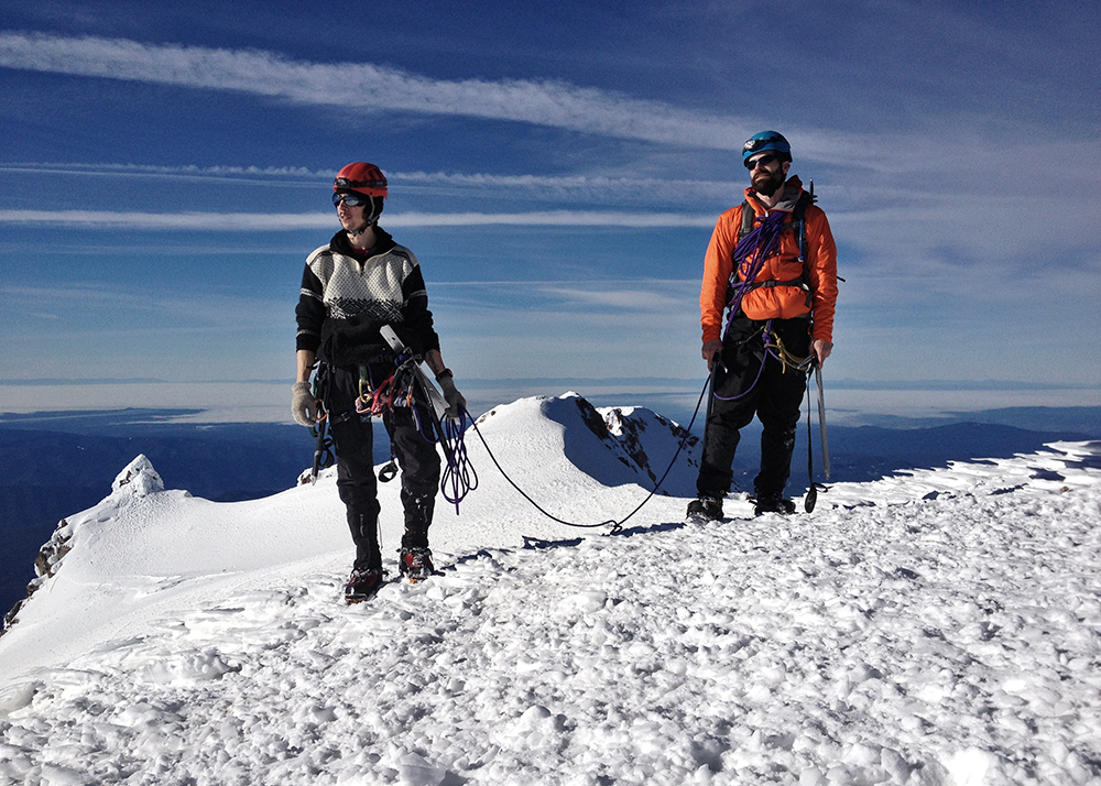
The typical summit goober shot - not much changes up here - proof that I was in fact a part of this days climb.
Parting shot of the largest bowling alley I've ever had to endure. We knew it was coming this day and made haste not to linger.
Gear Notes:
Glacier Gear, Pickets, Screws (didn't use), and some Slings
Approach Notes:
The ground up the Mile was like walking on concrete and nothing like I've experienced before. We put on our crampons and roped up before crossing the White River at 7,300 ft.
-
So good!
Sorry I never responded to your message from spring break about going out to the Wallowas. For me, that week couldn't have been further from a break as I was working what I recall to have been double time.
Thanks for the report! Also, my parents were married back in the 70's along the bluffs in Trinidad, CA and had their honeymoon out in the Trinities.
-
Way rad man!
I've been following your images on the phone all week and it's cool to now read the report.
Welcome to CC.
-
If you're good with navigation, and if the avy hazards are looking considerable-high, then you may also consider Diamond Peak. It too is very remote (a 10 mile approach in winter from Hwy 58 / Willamette Pass) but it does offer a good ridge to climb from that northern aspect and is the same or less in total mileage I'd imagine. I too bid you good luck.
-
Who eats carrots while hiking?
Jason, I know you prefer the PBR, and I want you to know I would've done you proud down in El Sal. w/ all their PBR-esque Pilsner, that is, had you been there to witness the shenanigans, but a carrot is all I had to offer at the time of this hike.
Josiah, on the other hand, brought the scotch.
Very cool TR and really good vid. James - what kind of camera and editing software did you use? You did an excellent job!I shot all of this on my Canon 7D and edited it in Premier CS4. Thanks!
-
Trip: Silver Star (Skamania) - "Ridge-Top"
Date: 1/11/2013
Trip Report:
A day prior to traveling down south for some adventures on the volcanoes of El Salvador (coffee sourcing) I wanted to scratch that cold itch one last time. Upon my return I finally had time to go through a few of my pictures from our hike.
Summit iphone picture of my friend Josiah Zukowski

It isn't much, but this has to be one of my favorite mellow day trips around the greater Portland area. This day conditions were particularly favorable. The photos are video stills and the video itself is my corny attempt at making a quick documentary.


Sturgeon Rock is now on my list of snowy Silver Star targets as well as that couloir

Beautiful Hood beast

Most ran back during our descent, but one of us decided it better to base jump

[video:vimeo]57996697
Gear Notes:
Snow shoes / Skis. Took my axes in hopes of reaching a potentially nice looking couloir once spotted during the summer, but it's farther north from the summit.
Approach Notes:
Use the southern ridge approach that passes by Pyramid Rock since this begins at a lower elevation. One week prior we could only drive within 3 miles of the trailhead, but this time around we were able to make it all the way to the start of the hike, despite icier conditions and a missing skid plate on our return home.
-
Crapo! You managed a lot of photo taking time while soloing. Well done on a fantastic route I hope to climb someday.
-
Thanks for finally making your way southbound! Are any of these new objectives, or have you done them all already, as one might presume?
-
What's the Ol' 27?
'twas my day of birth.
... and here's that lenticular time lapse.
[video:vimeo]44328088
-
The freezing level when I was up there yesterday was 14,000 ft. ... It felt like the mountain was coming down
I too was eyeballing that via the mountain-forecast site and YET AGAIN had to bail on Cathedral Ridge due to poor timing and circumstances. Best to stay off the mountain on these days. Lame.
However, I did hike up a little ways yesterday and witnessed an amazing set of lenticulars over, next to and in the distances of Hood. Also ate wild Alaskan Caribou, drank a few IPA's and enjoyed a bit of Woodford Reserve while up there in celebration of the ol' 27.


A short time lapse of the storm is exporting now. I'll add it later.
-
Nicely done!
... I don't think I've skied anything quite like it.Have you ridden the West Face Gully on Shasta before?
-
Sorry guys, for I gave outdated information there seeing as how those images are 2 months old, but they were eager to be seen.
I would've posted a TR back then, but nothing much exciting happened other than breaking a ski and post holing for 8 hours on our way out. Aside from that happening it's a great route.
-
Wondering about green lakes TH going back in to broken top and the south sister.
How abouts this trail? ...
... just be sure not to snap your binding off on the descent. Well, unless you're in the mood for type 2 fun. ; )


-
Made it up. We decided to stash our skis ... A great adventure nontheless.
Hey Jason, glad you made it up and down safely and had at least some ski action in, well done!
-
Have fun on that descent! I wish I could [better] ski. (Image taken July, 2011)

-
I've been eager to climb Cathedral Ridge for some time now, and still haven't a real idea of when I'll get up there, or if I'll get make it up that way this year, but I did manage to scout out a bit of that region yesterday.
Road 1828 is snow free up until two miles from the Top Spur trail head. From there I parked and hiked my way up, although it will likely melt out completely in a few weeks. The trail itself is well buried initially, but if you ascend Bald Mnt. it is snow free from there down to the valley - however I am uncertain about the McNeil Point trail. Overall route finding is simple.
And as the pictures reveal the Sandy Berg is opening, an avalanche came off the upper Sandy along with one on the west side of Illumination, but nothing else major. I wanted to get up closer to the waterfalls, but alas time ran out. Anyone ever climb the gullies around the falls off to the right there?


-
There is also that super awesome place with fixed draws that stays dry in a downpour...
Ended a LOOOONNGG multi-day photo shoot there yesterday.
-
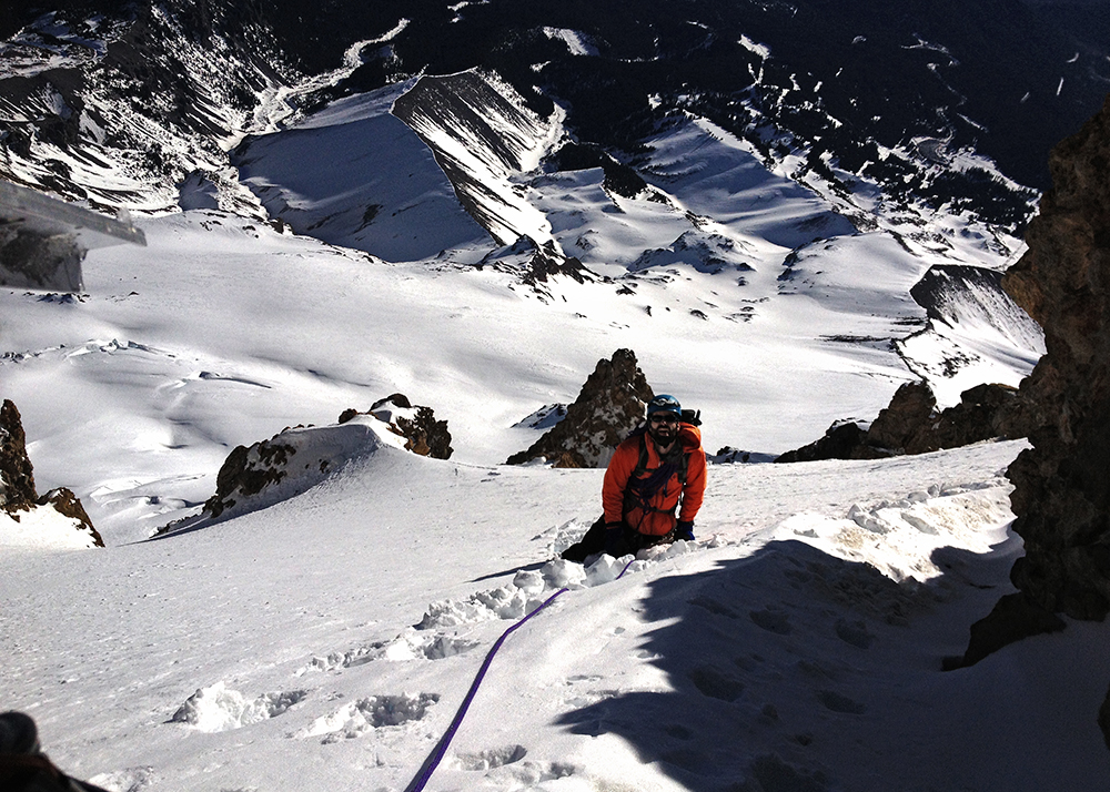
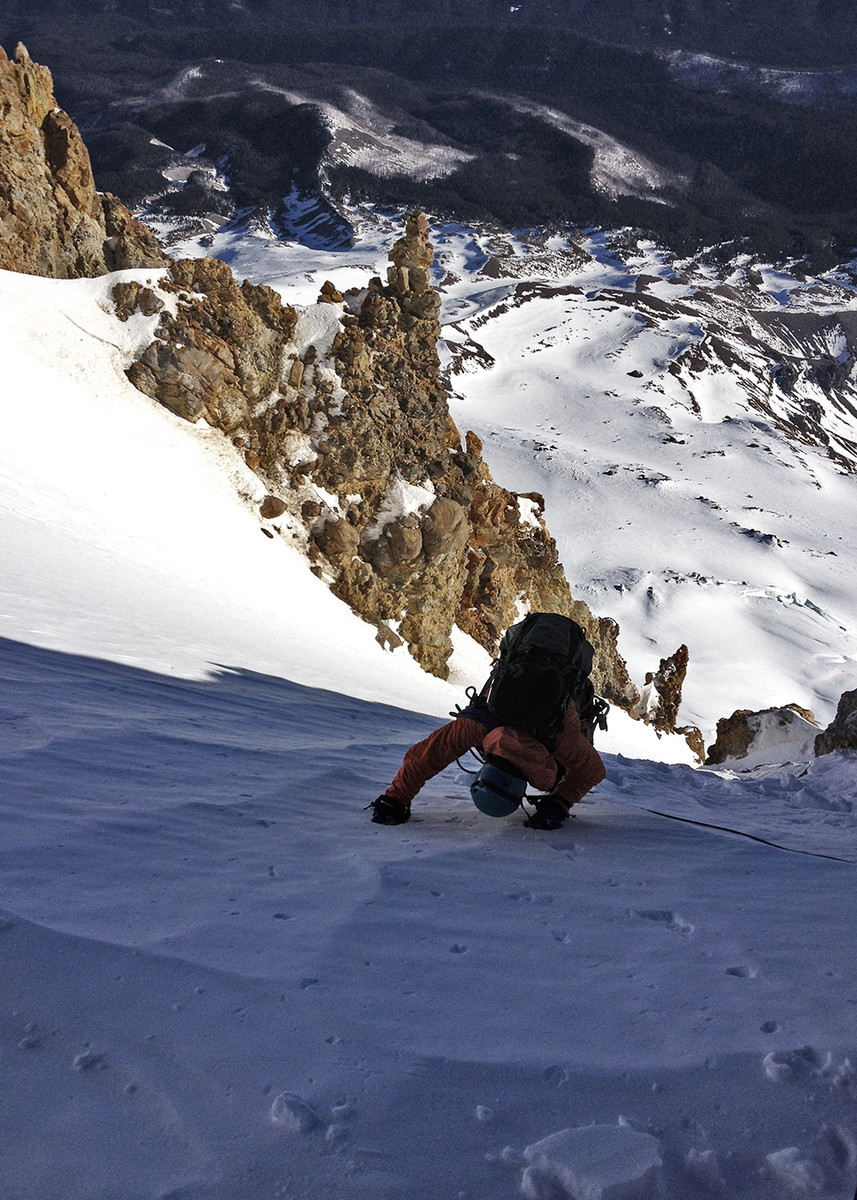
This picture is of their team climbing the Gates.

It was my birthday wish to climb one of the days that they happened to be filming up there.
I wanted Leuthold's, but we got too late a start and settled for cruising up the south side and it was definitely cool being up there with OFG.
My brother Isaac's voice is heard at 1:05, 11:56 and 27:34 and we're briefly seen climbing at 11:49.
-
sickkkk!!!
I made an amazing geologic discovery!
in Climber's Board
Posted
Due to the major fires that took place in southwestern Oregon in 2010 and that the Siskiyou is the only other NF outside of the little strip of Siuslaw that's more centrally located (less prone to fires) I would wager that's where this geological feature is located.
Plus that part of Oregon is already known for neat geological features. There are few roads as well, thus the likelihood for a long bushwack approach.
I'd bet it's near the Illinois River.