


moraineboy
-
Posts
10 -
Joined
-
Last visited
Content Type
Profiles
Forums
Events
Posts posted by moraineboy
-
-
You can walk or bike up the Cascade River Road though...also there is the way into Eldorado Basin via Sibley Creek Pass and Triad. I was up looking at it last weekend and there would be some somewhat steep firn/ice to deal with, that is a short section of ~35 degrees (snow covered now).
-
Eldorado might be a good option. Is the road open yet?
The road's closed at the Eldorado parking lot, making it an available venue to enjoy a really good storm.
Nope, Sorry, the Cascade River Road is still closed at Mile 12 for work on the Hard Creek Bridge at 12.7(Eldo Parking Lot is at Mile 20). It won't be done until mid to late October at the earliest. You can still access Monogram Lake T.H. and Hidden Lake T.H.
Lot's of new snow in the Mountains around Marblemount/Rockport...No reports as to depths but glimpses up at Marble Creek Cirque and Eldo look very white. Snow level looks to be ~4000 feet.
-
Regardless of all that, I really want to thank Steph for digging up this digital image--in the public domain no less! This is a wonderful gift to the Northwest mountaineering community and a great opportunity to acknowledge Berann's legacy.
Here! Here!
-
As far as the park boundaries, I like Lowell's idea of titling the map "The North Cascades". If you left the boundary in you could put in the caption "North Cascades National Park Service Complex, which includes North Cascades National Park, Ross Lake National Recreation Area, and Lake Chelan National Recreation Area". Those boundaries are important from a practical point of view because different rules apply and it is very confusing to most people, so here is an opportunity to show where the boundaries are. On that tack then, perhaps the NRA and USFS boundaries should be shown...get's cumbersome and busy rather quickly.
So, on the other hand..the political boundaries are artificial, don't lead to an aesthetic map, and may change anyway if the American Alps Legacy movement goes anywhere. How about a title something like: "The High Country of the North Cascades Ecosystem" ? Or...physiographically speaking the panorama doesn't cover the whole of the NCascades but it does cover the "The Crest of the North Cascades"
One correction: McGregor Mtn should be shifted right. It is the high point on the west side of the ridge. I think you have Rainbow Mtn labelled McG.
Below are some requests for labels, that I don't think will clutter it up too badly and would make the map more accessible to the hiking crowd too:
Hidden Lake
Sourdough Lookout
Desolation Lookout
Copper Ridge Lookout
Crater Mtn.
Lookout Mountain(maybe) or Cascade River Road
Davis Peak(maybe)
Rainy Pass or Lake
Bridge Creek and/or PCT
Easy Pass
Tower Mtn
Golden Horn
Hwy 20 label on the east side of Ross Lake
-
Anybody have any recent reports of the condition of the Inspiration and McAllister Glaciers and the approach condition for the Northwest Ridge?
-
Craig's death really unsettles me. Here's a super competent guy with a daughter similar in age to my own who dies on a route I've also done in the past. If I really believed something like that could happen to me I wouldn't be out there doing it. (Though thinking about what I've climbed in the last couple years maybe I have stopped doing it!)
Might be nice to get the word out, particularly to visiting climbers, that there is a better, or at least safer, start to the route than that commonly described.
Yes, this is a tragedy for Craig's family and friends and for our climbing community. My heart goes out with great condolences too.
The truth is that it could happen to anyone at any time. We use the rationalization, "that it can't happen to me" and accomplish a lot of things, but we are always rolling the dice with objective hazards. It is true there are ways to minimize this risk, but sometimes it doesn't matter. This is the same theme with the fall on the North Face of Mt. Terror earlier this summer. Despite their names the mountains don't care. They just are as they are and they have been shedding rock and ice for millions of years. Climbers must be willing to assume this risk when alpine climbing. It is clear and real, make your decision from there.
Thanks Darren for getting that beta out there!
-
Nice work! I was wondering how the rest of your trip went! We saw your tracks down amongst the mega crevasses on the Boston Glacier from Sharkfin Tower.
Your Friendly Neighborhood Ranger.
-
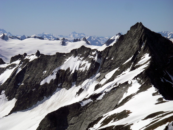
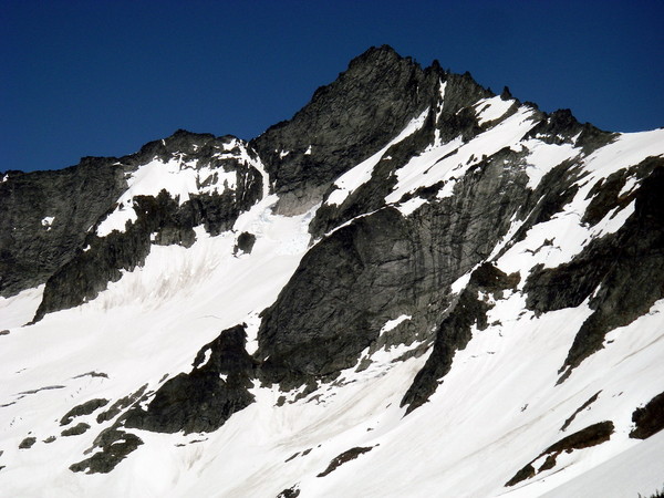
They say a photo is worth a thousand words....here is 2000+ for ya. These were taken from Sahale Arm last Saturday, June 28. Expect some changes as this week has continued with sun and warm temps in the alpine. Call The North Cascades NP Wilderness Information Center in Marblemount for latest conditions on the Cascade River Road. The road will be opening to the Cascade Pass TH sometime in July. Phone: 360 854-7245
Don't forget to get a backcountry permit for overnight camping in the Wilderness and blue bags at the WIC in Marblemount. WIC hours: Daily, Sunday - Thursday 7:00am - 6:00pm, Friday and Saturday 7:00am - 8:00pm
-
Anybody on Silver Star (off the North Cascades Hwy) in the last week or so? I've always been up there ski touring early season and was wondering if we should bother bringing a rope for the glacier or other possible difficulties. We'll most likely approach from Burgundy Col. Thanks!
Labeled illustration of North Cascades
in Climber's Board
Posted
Three cheers for the bro-deal grassroots/community effort! To be clear, it is not actually a for-profit concessionaire that sells posters, cards, books, maps, etc at the visitor centers it is a non-profit organization. The organization that will be taking it over starting 2010 is North Cascades Institute. I would venture a guess that most folks on CC would be glad to know what NCI is all about:
www.ncascades.org
From their website:
North Cascades Institute seeks to inspire a closer relationship with nature through direct experiences in the natural world. Our mission is to conserve and restore Northwest environments through education. Since 1986 we have helped connect people, nature and community through science, art, literature and the hands-on study of natural and cultural history. Our goal is to help people of all ages experience and enjoy the mountains, rivers, forests, people and wildlife of the Pacific Northwest – so all will care for and protect this special place.
North Cascades Institute is committed to innovation and excellence in environmental learning and leadership in the nonprofit community. We believe that sustainable communities are built on healthy environments, vibrant economies and social equity. Toward that end, four key themes run through all our programs:
The convergence of natural and cultural history, science, humanities and the arts
Human history as integral to the history of landscapes and wild lands
Respect among individuals and the broader community
Exploration, reflection and stewardship in the out-of-doors
Teaching all ages, we offer:
Seminars and retreats
School programs and summer youth adventures
Teacher education and internships
Volunteer stewardship programs
Graduate M.Ed. in environmental education
In 2005, North Cascades Institute opened North Cascades Environmental Learning Center. A partnership with the National Park Service and the City of Seattle, the Learning Center is surrounded by millions of acres of protected public lands. It is a hub of discovery into one of the wildest, most biologically diverse landscapes in North America. Learners of all ages come to explore and participate in innovative programs that inspire and enrich their lives.