


Jamin
-
Posts
148 -
Joined
-
Last visited
Content Type
Profiles
Forums
Events
Posts posted by Jamin
-
-
I found out that there was a gate at Olney Pass and I wasn't up for a 22 mile daytrip. I considered doing another FWA, but I would have had to ford a river, which was probably chest deep after last night's rain. I ended up doing Silver Peak (5600+ feet, class 3) with another climber. It was rather frigid up there.
I will be free after Christmas for climbing. Let me know if you are going somewhere.
-
I and a couple of other climbers are probably going to attempt Red Mountain above Spada Lake the 22nd or 23rd (Friday or Saturday). There is no record of a winter ascent of this peak. This peak was first climbed in 1958, and the original register is still on the summit with a total of about 5 entries. Only about 10-20 people have ever summitted Red Mountain. Red Mountain is class 4 and should not be extremely technical. It is only climbed infrequently because it is not as simple or as high as other surrounding peaks.
If you are interested in bagging the first winter ascent, contact me at j7jamin at yahoo.com .
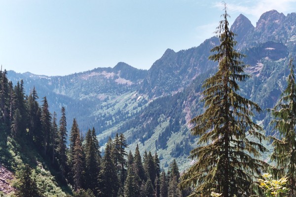
Red Mountain is the pyramid in the photo. The other side is much easier than the side you can see.
-
I am planning on doing the First Winter Ascent of Red Mountain in the Sultan Basin this Friday if I can find a partner. Weather is supposed to be great. Terrain will be mixed snow and rock. Climb is rated class 4, but it is winter now so you you know how it will be. If you are interested let me know at j7jamin at yahoo.com .
-
I am a student, and I am off work and school for three weeks. I am interested in doing some awesome climbs in the cascades. I have a car, 3 ice tools, an ice axe, a few ice screws, a set of stoppers, a 50 m rope, biners, and extensive mountaineering experience.
I am thinking about doing some FWA's (First Winter Ascent's) of a few peaks in the highway two area. There are less than a half dozen peaks left in the highway 2 area which have never been climbed in the winter. A few examples of FWA's and possible FWA's include Engadi, Snowslide Peak above Index, and Red Mountain above the spada reservior. I have also considered a climb up Overcoat Peak near Chimney Rock, but I would hesistate to do that unless there were perfect conditions.
I am also willing to do ice climbing and short sections of rock practically anywhere in the cascades. If you are going on a climb, let me know. You can contact me at j7jamin at yahoo.com .
-
If you want to do something tough, come climb Glacier Peak with me. Glacier peak is #5 on the hundred highest list and I guarantee it will be a challenge for you. I will start on the morning of the 19th and try to get out the next day. If you think that you are up to it, e-mail me at j7jamin at yahoo.com . We will be able to do some fun stuff on glaciers, and I will definitely be there for you if you fall into a bottomless crevasse.

-
Well, on the 19th, 20th, and part of the 21st, I plan on doing Glacier Peak. If you think that you could do this climb, I would be glad to have you along. This climb would definitely be a challenge for you, and it would be a fun trip as well. I personally am one of those guys who likes to push hard so I guarantee that I will be able to keep up with you. Are you in good shape, my last four partners all slowed me down at least a little.
Buen aventuras.
-
I just found this picture on the net. It appears that Disappointment Peak may be difficult and time-consuming to climb over so I am thinking about climbing around it via the Cool Glacier.
http://www.summitpost.org/view_object.php?object_id=128751&context_id=155642
-
http://www.trailjournals.com/photos.cfm?id=118591&back=1
My nemesis!
I have the 19th 20th and part of the 21st off. Anybody want to come along on this awesome climb. Glacier experience is not completely necessary, but it would be very useful. The crevasses will be opening up soon so crevasse rescue experience would also be a plus. I need a partner badly so I would take nearly anyone. However, you will need to at least bring a harness. I will also put forth the requirement that anyone who goes with me must be able to consistently do around 800 feet of vert in one hour on trail. Some scrambling experience is also mandatory. Reportedly, there is some 3-4th class or steep ice climbing on the route.
We would be going in via the disappointment cleaver route, which, since 2003, is the easiest route on the mountain. This route has less ice than any other route. To get to the summit will require a little more than 10500 feet of gain and 15 miles of hiking and climbing. About one mile will be on glacial ice, and 9.3 miles will be on a very good trail. I will be willing to carry the rope, which will be necessary for the walk on the retreating White Chuck Glacier
On my last attempt in 2004, I merely made it a little past White Pass because my brother got stomach flu and was throwing up. It was probably a good thing because I was completely unprepared for a climb of this magnitude. After doing Dome, which was probably more difficult than this climb, I believe that I finally am ready. I already know the route all the way to the White Chuck Glacier. I almost guarantee that a strong party would be able to make it to 8000 feet on the first day. It generally takes 5.5 hrs to get to White Pass.
I would also appreciate advice from other people who have done this climb. If you have the slightest scrap of info, let me know.
I would recommend that you do not miss this climb. If I were you, I would ask for time off work. It is worth it. Glacier Peak is a true wilderness volcano. It is climbed less than any other major peak in the state. It is also number 5 on the hundred highest list. Most of the information on the net is from before October 2003, when Glacier Peak could be done in a day
http://www.summitpost.org/object_list.php?parent_id=155642&object_type=3
http://www.summitpost.org/route/155642/disappointment-cleaver-gerdine-ridge.html#chapter_2
http://en.wikipedia.org/wiki/Glacier_Peak
http://www.peakbagger.com/peak.aspx?pid=1972
http://staff.washington.edu/skykilo/GlacierPk2/GlacierPk2.html
-
Glacier Peak is my nemesis because I failed on it in 2004. My brother and I were planning on doing the disappointment cleaver route. We reached the trailhead at 5:00 pm and reached White Pass at 11:00 pm, where my brother proceeded to start vomiting. The trip deteriorated from there.
We did Dome in two days, but I would recommend three to anybody who wants to try it. Most of the time I was too tired to really enjoy myself.
-
I would guess that at this time most of the crevasses would be totally covered. I definitely would rope up if I were you. I am sure there are plenty that you cannot see until you are in them. However, the snow bridges should be firm for the most part.
-
The Chikamin Glacier is known to be heavily crevassed. We could see plenty of crevasses from the summit.
-
Climb: Dome Peak-Dome Glacier Route
Date of Climb: 7/1/2006
Trip Report:
Dome Peak
After resting for about 5 hours but not really getting any sleep, I and my climbing partner, a cool guy named Bala, woke up at 4 am, got our gear together, and headed to the Downey Creek trailhead. The road is closed about 1000 feet before Downey Creek, and a ladder is used to access what is left of the bridge. Once on the other side of the bridge, we quickly found the Downey Creek Trail and reached Bachelor Creek in less than three hours. The distance found by plotting the trail on topo is six miles, but it is probably a bit longer due to uncharted twists and turns. The Bachelor Creek Trail, which begins directly on the other side of the creek, was in almost excellent shape at first, but because it is unmaintained, we soon found ourselves scrambling over quite a few blowdowns. The trail really was not all that bad, and I hiked the entire length of it in shorts. It did take a long time because it would twist and turn so much. At around 3500 feet we started going through a slide alder, salmonberry, blueberry, etc. type brushfield. At most places, the narrow tread was visible. The exception was at the footlog to the other side of the creek. At the creek crossing at around 3900 feet, there is a fork. One fork parallels the creek and eventually ends in the middle of a brushfield. The other fork crosses the creek on a foot log and heads up valley. We had to scout around for a few minutes before we actually found the trail on the other side of the creek. Once on the other side of the creek, there were a few places where avy debris obliterated the trail, but travel was not difficult until we reached the old 2002 avalanche swath at around 4600 feet. At this point, the trees on the entire hillside were obliterated as well as most of the trail. In a small way, it sort of resembled pictures of the Mount St. Helens eruption. The avalanche had swept down the hillside, torn the entire forest to splinters, and then went partway up the OTHER side of the valley. We headed up where the avalanche had scratched the hillside down to nearly bare dirt. We soon found a trail which we followed until I decided to merely head upward toward the pass to Cub Lake. After scrambling over many blowdowns, we reached a small valley where Bala’s altimeter said 5050 feet. He pointed out a green hillside that he said that we needed to go over. I was skeptical. The valley that we were in was uncannily like the hanging valley at the head of Bachelor Creek, which is at 5400 feet. I took a compass bearing and found that I was correct. We reached the pass above Cub Lake at 4:00, six hours after leaving Downey Creek. At the pass, I decided to attempt the traverse on the slope above Cub Lake because I did not want to lose elevation. We had traveled only about 500 feet before we encountered a sketchy section of rock. I crossed it, but Bala balked and said he did not want to continue the traverse. Because it looked like we would be doing some more rock, I decided to descend to Cub Lake, which is 90% frozen. I definitely think that this traverse is doable, but it will probably take more time than merely descending to Cub Lake. At the outlet of Cub Lake, we were able to see Itswoot Ridge. On the ascent of the ridge, both Bala and I were getting tired. We had already done 13 hours with 30-40 pound packs. As a result, we decided to camp on the ridge and get an early start in the morning. The next morning, we woke up at 3:50am, got our gear together, roped up, and were headed toward Dome by 5:00. The route was pretty straightforward, and we could see where we needed to go all the way to the Dome Glacier. One thing that is really important is that we gained the flat part of the glacier via a snow gully on the left-hand side of the icefall. We did not traverse beneath the icefall, which is recommended in some trip reports. Once on the flat part of the glacier at 7600 feet, we headed toward the obvious scramble route up the gully on the left hand side of the main Dome Peak ridge. The glacier was really not all that bad, but there were very few obvious crevasses. Most of them were completely covered by sturdy snow bridges, which will melt out later. It will definitely be more broken up and dangerous later in the season. Once we had gained the summit ridge at an estimated elevation of 8500 feet, we continued up to the summit via easy snow slopes. The ridge became steadily more exposed on the way up to the summit. With only 50 feet more to go, we came to a highly exposed section of rock. The main ridge appeared to be a knife-edge, which we would have to straddle to get up to the summit. The thought of having one leg hanging off into space did not appeal to me so I headed toward a crack that led up to the summit. At that point, I found out that it was overhanging and class 5ish. However, there were a few handholds on a fifteen-foot slab right next to it. To me, it looked better than the ridge, and I could see a rappel anchor in part of the crack. I figured that if I got to it I could merely rappel on the downclimb. Bala did not like the look of it and said that he was going to try to climb along the ridge. He soon discovered that there was an easy 4-6 inch wide ledge nearly all the way to the summit. It was not obvious from where we were. It was highly exposed class three, but it really was not all that bad. We rested on the summit and caught the views. It was an awesome summer day. I could see my nemesis Glacier Peak to the south as well as nearly every mountain within 50 miles. However, because we knew we had many miles ahead of us, we only spent 40 minutes on the summit. Several glissades and long traverses brought us back to our camp on Itswoot Ridge. We packed up and headed down fast. We hit the trail at Cub Lake and gained the ridge, but we soon lost the trail in a snowfield. We then merely headed down to Bachelor Creek through open forest, and hit the trail at around 4500. The rest of the trip was uneventful. We did meet six other people on the trail. All of them were taking four days to do Dome and several surrounding peaks. We did Dome in two. We eventually reached the car at exactly 10:00pm. It had been a long 17 hour day.
Stats: To Dome and back was 28 miles and 11000 feet of elevation gain. You can see the pictures here. http://www.nwhikers.net/forums/viewtopic.php?t=14969
-
I am pretty sure it will be Dome. I already have one climber lined up. It would be Friday and Saturday and possibly the very early morning on Sunday. If I were you, I would not miss this awesome trip. http://www.bodyresults.com/a2dome.asp
http://www.summitpost.org/view_object.php?object_id=15284
http://www.summitpost.org/object_list.php?parent_id=150357&object_type=3
-
I was thinking about just doing three fingers to the lookout. It depends whether I have Saturday off also. If I have Saturday off I will definitely try for Dome. I will try to figure out my schedule tonight. Good self-arrest skills would be essential on both climbs, but I think you would be ok.
-
See my post about Dome Peak or Three Fingers. I am currently looking for a partner. However, I predict that Dome would be the most brutal climb you will ever go on. It is 27 miles long with 9400 vertical feet. I am also thinking about doing three Fingers, which is not very hard. I do have access to two ropes. Basic skills such as self arrest are required.
-
It looks like I may do either Dome Peak http://terraserver.homeadvisor.msn.com/image.aspx?T=1&S=12&Z=10&X=806&Y=6689&W=3 or Three Fingers. I will probably start either thursday afternoon or very early Friday morning. I am not sure whether I have Saturday off yet. I will probably know tonight. Let me know at j7jamin at yahoo.com if you are interested in these awesome trips.
-
I may be doing it sometime this week. It would probably be three days. I have read several trip reports and it seems that the general time for an experienced party is 2.5 days.
-
I am going to do Dome Peak (8900 feet) in a week or two. I do not have the exact dates set. It would probably be a two-three day scramble. It will definitely be a challenge that may be too much for me or you. The entire trip would be 27 miles long and with 9600 feet of elevation gain. About 14 miles would be on trail. Dome peak is an awesome summit. If you are interested, e-mail me at j7jamin at yahoo.com
http://www.bodyresults.com/a2dome.asp
http://www.summitpost.org/images/original/140262.jpg
http://www.summitpost.org/mountain/rock/150357/dome-peak.html
-
My partner and I are going to meet at the old Carnation smokestack in Monroe at 5:00 am. The smokestack is located near grocery outlet and is about 300 feet high. It should be a good trip. The weather should be great.
-
I am going to reattempt kyes peak this Saturday. I almost made it to the summit last Saturday so I know the route pretty well. Kyes is the highest peak in the monte cristo range. This peak has the most awesome glissade I have ever experienced. We did almost 1000 vertical feet in five minutes. The views are great also. Here is a link to my previous trip report. E-,ail me at j7jamin at yahoo.com if you want to come. http://www.nwhikers.net/forums/viewtopic.php?t=14589&sid=8cd8ab05e8a826259ac182eff4360e78
-
I am going to try to do some hard class 3 scrambling this Saturday. I was thinking about doing Kyes Peak, but I would be willing to do something else. Kyes Peak, the highest peak in the Monte Cristo Range, is 12-13 hours round trip at this time of year, but it has great views and awesome glissades. It is around 5500-6000 vertical feet and 5+ miles to the summit. If you want to come, let me know by e-mailing me at j7jamin at yahoo.com. Here are some Links.
http://www.summitpost.org/image/35855/151669/the-columbia-glacier-which.html
http://www.summitpost.org/object_list.php?object_type=3&parent_id=151669
http://www.wta.org/~wta/cgi-bin/wtaweb.pl?7+reports+displayM+2006060311
-
I am trying to find a partner for a climb this Monday. I am thinking of Merchant Peak, Kyes Peak, or Mt. Index via lake serene, but I am open to other climbs or scrambles. I have absolutely no experience on technical rock, but I have plenty of experience on steep snow. Merchant peak has a couple of steep couloirs to the summit. E-mail me at j7jamin at yahoo.com to make arrangements.
First Winter Ascent this Friday
in Climbing Partners
Posted · Edited by Jamin
Well, I am still determined to get a first winter ascent (FWA) of a peak. I am thinking about doing a certain peak in the hwy 2 area. Getting to the peak will involve 6.8 miles, 4400 vertical feet, and a class 3 river crossing all offtrail. I scouted out a ford of the river about a week ago. There were 3 main channels and 3 smaller channels. I crossed all but the last channel solo. I could have crossed the last channel (It was actually shallower than one of the channels that I crossed), but I had lost feeling in most of my toes. Hip waders would be extremely useful for this climb. The river should be no more than waist deep. When I crossed it, it was just above my knees. This will be a difficult but exciting trip.
If anyone is interested in coming, let me know at j7jamin at yahoo.com . This is not a trip for people without extensive offtrail experience.
Weather is supposed to be partly cloudy and clear.