


ericandlucie
-
Posts
43 -
Joined
-
Last visited
Content Type
Profiles
Forums
Events
Posts posted by ericandlucie
-
-
Here's a link to the brand new Access Fund action page: http://www.accessfund.org/c.tmL5KhNWLrH/b.5208267/k.8C84/Action_Center/siteapps/advocacy/ActionItem.aspx?c=tmL5KhNWLrH&b=5208267&aid=16339
Go there, enter your contact info, sign the letter, and poof, e-mails are out to all county commissioners! Couldn't be any easier.
-
Fairweather: I have enough work trying to get people mobilized against this thing. If I had to answer all the idiotic comments made on these fora, I wouldn't do anything else.
How convenient too, that you'd use one comment like that to excuse yourself and everyone else from inaction... have you sent any e-mails?
-
Doesn't anyone care?
-
bump
Come on people, write some e-mails!
-
Hi Brad: I'd recommend sending to all e-mails listed, although in the short term, Clark County commissioners are the highest priority. Just write one e-mail, then send it to each one of them, one at a time. Easy.
-
If you love Red Rocks, please read on.
If you've ever climbed at Red Rocks (who hasn't?), you understand how real the development pressure to this unique area has been in the last many years. The Las Vegas suburb of Summerlin has now reached the very edge of the conservation area. Some of us remember the days (only 15 years ago) when it was a long semi-rural drive from the edge of town to Red Rocks. But at least for now, development has stopped from that direction and is still relatively far and largely out of sight from the cliffs and canyons we love.
That is about to change.
If local developer Jim Rhodes gets his way, the entire Blue Diamond Hill (the massive hill at the center of the RR cirque, that forms the foreground of the view from anywhere at Red Rocks, and the backdrop to the BLM campground, and is currently completely undeveloped) will become a brand new town of 5,000+ homes and about 15,000 residents, complete with shopping malls, schools, etc. An official plan has recently been submitted to the county by the developers: it effectively puts a brand new mid-size city right in the middle of the conservation area.
The distance between the escarpment and the closest modern developments will drop from the current 10 miles to less than 3.5 miles.
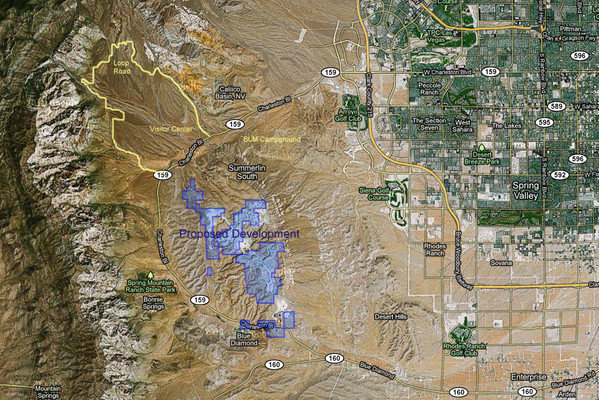
This translates to an increase in the light and noise pollution by a factor of more than 8, not even accounting for the buffer effect played by the currently undeveloped hill! If this plan goes forward, you may not even need a headlamp anymore for those early morning approaches to Resolution Arete!
For more details about the history of this situation, please see the first two references below.
On August 17 at 9AM, the Clark County Zoning Commission will meet to approve/disapprove this plan.
Opposition to the plan (www.saveredrock.com) has to date remained localized around the small town of Blue Diamond and local Las Vegas newspapers, largely due to a lack of information among the larger community.
Because climbers are uniquely attached to this area, I believe they are the most likely group to stand up for its preservation. For the last few weeks, some of us have been trying to spread the word within the climbing community. A public outcry to the officials involved, particularly if coming from the entire nation, may have a good chance of changing the outcome and saving this unique area.
Here’s what you can do (in order of decreasing urgency, but remember, the key decision will be made on August 17, so there are only a few days to act):
1. Call or write e-mails to Clark county commissioners:
Do this now, and certainly before August 15! See contact information below.
2. Ask your friends to do the same: please forward this e-mail to all your friends!
3. Sign the petition
4. Send e-mails to congressmen and the BLM
5. If you live reasonably close to Vegas, be at the Clark County zoning commission meeting on August 17, and either speak up or wear/carry evidence of your position on the issue.
Please ACT!
On behalf of the future of Red Rocks: thank you!
APPENDICES
Contact Information:
Clark county commissioners:
All commissioners can be reached by phone at: (702) 455-3500
All commissioners can receive faxes at: (702) 455-3271
Clark County Commissioners, 500 S. Grand Central Parkway, Las Vegas, NV 89155
Steve Sisolak, District A, ccdista@ClarkCountyNV.gov
Tom Collins, District B, ccdistb@ClarkCountyNV.gov
Larry Brown, District C, ccdistc@ClarkCountyNV.gov
Lawrence Weekly, District D, ccdistd@ClarkCountyNV.gov
Chris Giunchigliani, District E, ccdiste@ClarkCountyNV.gov
Susan Brager, District F, ccdistf@ClarkCountyNV.gov
Mary Beth Scow, District G, ccdistg@ClarkCountyNV.gov
BLM Southern Nevada District Office:
Mary Jo Rugwell, District Manager,
4701 North Torrey Pines Drive
Las Vegas, NV 89130
Phone: 702-515-5000
Fax: 702-515-5023
Email: lvfoweb@blm.gov
NV Congressmen/women: (even if you don't live in NV, it doesn't mean you shouldn't contact them)
Senator Harry Reid (D- NV), 202-224-3542, http://reid.senate.gov/contact/index.cfm
Senator Dean Heller (R- NV), 202-224-6244, heller.senate.gov/contact_form.cfm
Representative Shelley Berkley (D-01), 202-225-5965, shelley.berkley@mail.house.gov
Representative Joe Heck (R-03), 202-225-3252, https://heck.house.gov/contact-me/email-me
Upcoming Clark County Zoning Commission meeting:
August 17 (Wednesday), 9:00 a.m.,
Clark County Government Building, Commission Chambers
Government Center, 500 S. Grand Central Parkway, Las Vegas, NV.
Suggested key points for use in e-mails to officials:
• Red Rocks is a National Conservation Area, of considerable interest to all Americans and foreign tourists, with a unique oasis-like flora and fauna and amazing scenery.
• Red Rocks is a world-renowned climbing area, visited each year by thousands of climbers from the US and abroad. Those climbers spend their time and money at Red Rocks because of its unique beauty and undeveloped character.
• Contrary to biased assertions in the developer’s plan, the proposed development is in plain unobstructed view from most of the hiking and climbing locales in the Red Rocks NRA. The top of the Blue Diamond hill is in fact the most immediately scenic feature from these places.
• There are plenty of remaining areas available for development in the Las Vegas valley. The Red Rock Canyon NRA is a unique resource to the people of Las Vegas and visitors from all over and it must be preserved
References and Links:
“Rhodes submits revised plan for developing Blue Diamond Hill,” By Scott Wyland, Las Vegas Review-Journal, July 7, 2011. http://www.lvrj.com/news/rhodes-submits-revised-plan-125130408.html
“Jim Rhodes is Coming: his homes will rise in Red Rock, but how sprawling is the developer's secret plan?” by Jason Whited, Las Vegas City Life, February 24, 2011, http://www.lasvegascitylife.com/articles/2011/02/24/news/local_news/iq_42408246.txt
The developer’s plan, ironically titled “Gypsum Reclamation Concept Plan”, Gypsum Resources, LLC, June 29, 2011, http://www.reviewjournal.com/media/download/rhodes_plan.pdf
Website of the local action group: www.saveredrock.com
Mountainproject.com thread about the issue: http://www.mountainproject.com/v/red-rock-threatened-by-development/107227001
SuperTopo.com thread: http://www.supertopo.com/climbers-forum/1565955/Red-Rocks-under-imminent-threat-of-development
-
Woman of Mountain Dreams: climbed it last year. It may be one of the best lines at RR, but not that great a climb, overall, although the exposure on the upper part is amazing.
First 3 pitches mediocre. Crux not that hard... bolts a bit old. Above crux, rock quality deteriorates. Some fun climbing, but scary friable rock in many places. I'd still recommend it because of the line, though Inti Watana into the top of Resolution Arete would give you better climbing IMO.
Full TR and pics here.
More TRs and pics of several other RR classics here.
-
Hey Dru:
so you're the one who chopped that tree! I told Lucie that it looked like someone had cut it with a knife... hope your ice axe was sharp! Thanks for that anyway!
Just did the S ridge on Gimli yesterday. Great climb... and the views!
-
Hi Rad:
the bugs were not bad at all at the lake. There were some on the climb, but again, pretty mellow by Cascades standards.
-
Maybe my memory is failing me on the Prusik chimney... I don't remember much trouble getting established into the CBR chimney. I think I used a hand jam in the flake, then grabbed the top edge of the flake, then probably jammed the crack in the back? I am tall (6'4"), which may make it easier for me to reach in to the jams...
-
Ha! Great TR guys! Pretty funny...
Funny too that we were going up the trail on Sunday, when we saw you! We told each other it was strange that two climbers were coming down with little in the way of gear at 10AM! Now I know why... Hope you didn't freeze your asses too badly.
We climbed the route on Monday (Aug 4), after a camp at the lake (that approach in one day is just too much, thank you). Found the route all dry as you did, except from some slime in the last 2 moves on the crack pitch. Good hand jams though so no problem.
The 12a roof seemed over-rated... best proof of that is that I freed it with just one hang. Managed to on-sight the whole route except for that move
 . Overall a good line, although I thought the "approach" pitches to the base of the corner were not very good. The top pitch or two of easier climbing to the summit were also very licheny and had scary loose blocks.
 The chimney was painful, but I don't think it is as bad as reported by many. Lucie followed this free with a pack on (though she took it off for the second section). Clearly harder than 5.8 but maybe not 5.10 either. I remember the chimney on Prusik, for example, as harder than this (and it is rated 5.9). Just don't want people to fear this route because of that pitch.
We toproped to the top of the balanced rock by lassoing the rope over it. If you stand at the rap anchors and manage to get the rope behind the nose on the right, it is quite secure. The two moves from the rap to the top are quite stiff...
Took us about 15 hours round trip from the lake, with a very leisurely pace on the approach (wanted to save our energy for the climbing), and a ~1 hr wait at the base (we were hoping it would get warmer... it didn't).
Some clarifications / Stuff I wish we had known before going:
- the route is sort of a long alpine crag route: the descent goes right by the base. Bring whatever you want/need, leave it at the base, and grab it on the way out. Good boots would be nice to have for the approach gully. As would some extra water to leave at the base for the way down. There is some snow left near the base of the route, but no flowing water that we could see.
- the descent IS the easiest, most direct, and quickest I have seen in the cascades. It is also very obvious (with daylight...
 ). I went down in my rock shoes, Lucie had lightweight approach shoes. At the very end, stay pretty close to the wall. The last 15 ft are easiest right next to the rock. This will drop you onto your packs, at the top of the boulder field.
- there is a permanent stream in the first third of the approach gully. You cannot miss it. Good place to re-supply. No need to carry water from the lake (as we did...)
- there is a beautiful place for a camp at the bottom of the boulderfield (at the top of the approach gully), directly below the route. Flat sand and trees. Only problem is the lack of water, although I guess you could melt snow if you brought enough fuel. Carrying an overnight pack through the alders and up the steep gully may be a deterrent... If I had to do the route again, I wouldn't do this. I'd still camp at the lake (assuming you can get a damned permit).
- I'll second the rack beta: doubles from tiny cam to #3 camalot, one #4, and one set of nuts. This was more than I needed, the pro is quite varied on all pitches.
- counting the summit block as a pitch, we did 12 pitches in all: first pitch to access the 10+ crack, then 8 pitches exactly as shown in Nelson (all short pitches), then 2 pitches to the rap anchors, then a 15' pitch to the top of the block.
- we had double 60m ropes as we always do, but I would take double 50's if I did it again.
- as you mentioned: watch out for the pinch at the end of the 11a roof traverse. I had to place two medium nuts upside down at the lip to keep the ropes from jamming.
If we get around to it, we'll post a TR (yet another CBR TR...) sometime soon. Don't hold your breath though... I got about 50 tax forms to take care of first

-
When we did the UR, we camped some distance past Ingalls lake, on the way toward Goat Pass (lovely spot with company... mountain goats). We climbed the UR in one day from that camp, descending via Cascadian couloir. We simul-climbed long portions of the ridge, up to the gendarme. You will want rock shoes for the Gendarme pitches. We had Aluminum strap-on crampons on mid-weight hiking boots, and aluminum ice axes. Getting back to camp via Cascadian is a long way, but straightforward and non-technical. If you're reasonably efficient on alpine, you shouldn't need to bivy on the ridge. I think the lack of water makes this option unappealing.
We have a detailed report, pics, etc, on our site:
Hope this helps. Have a great time! If you haven't been in the Cascades before, you'll love it. For that reason alone, it would be a shame to do this car to car (not to mention a major pain).
-
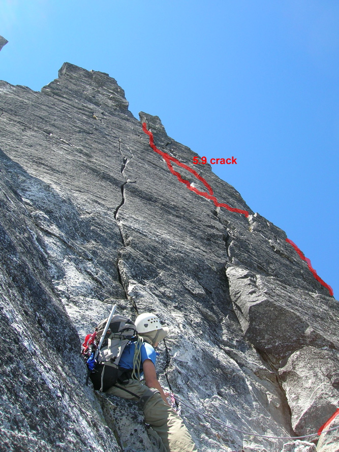
Thought I should clarify something: there are two possible cracks for this pitch: the one to the right is apparently 5.9. The other one, directly above the ledge, is much cleaner looking and - I think - harder. We climbed the latter, which I still feel is about 10a.
The pic below (borrowed from Steph, http://sabegg.googlepages.com) shows the 5.9 crack in red. The other crack is clearly visible right above the climber. Hope the link works...
-
Hi there:
We're planning to climb in New England this fall. We've never climbed there (except for ice).
Based on what we read, we're planning to climb at Cannon Mountain, Whitehorse Ledge and the Gunks. What's the best season to be there? Any recommendations on must-do routes?
Would you recommend climbing in the Adirondacks or Acadia National Park as well?
Help! and thanks!
www.ericandlucie.com
-
Thanks guys.
Goatboy: about that crack, I agree with 5.9 for most of the pitch, but we both felt that the final moves to traverse right, out of the vanishing crack to the belay were 5.10a... go figure!
-
Just posted a TR from an unsuccessful attempt on Mt Barff, this last December ('07).
-
Hi All. Just finished a TR about our climb of the East Ridge of Inspiration Pk (last summer). Enjoy

-
Rad & Curtveld: Totally agree. Nothing to dislike about the route. Great line. A very good alpine route, but the climbing after p4 is nothing too special. I'd still recommend it though!
-
Hi Rob:
We were just climbing there two months ago.
When we got there in mid-March, it was brutally hot. We climbed some in the Grampians, where it is marginally cooler because of the altitude (BTW, we thought that by far the best cliff in the Gramps was Mt Rosea: 3- to 5-pitch trad routes on extremely good rock).
The weather became pretty good for climbing at Araps by early April. We climbed on-and-off there for a couple of weeks. Most days we had a mix of rain and sun, but could climb between showers.
We've heard that fall is better than spring because the flies are really horrendous in the spring.
Since you asked, I must tell you that we were quite disappointed with Araps. It is not a bad crag, but I think it is greatly over-hyped by Aussies, who often refer to it as "the best crag in the world"... It's a nice spot, great rock (though very slippery in place and kind of ugly looking), great cheap camping (AU$2/person/night, with toilets and non-drinking water). You can walk to almost all climbs from camp. We didn't find the routes very inspiring (inobvious lines). Most of the climbs are of the steep and juggy variety. Almost all climbs are trad.
The area is very popular, particularly with beginners because the easier routes are quite good. Crowds are bad on weekends (climbers from Melbourne), but the place is pretty quiet during the week. Avoid Easter weekend when the crag is overtaken by many thousands of climbers... unless you're going there to party.
Guidebook is out of print. A new one is supposed to come out in June... though it's been delayed many times already. The climbing store in Natimuk (small town near Araps) has decent temporary guidebooks for sale and will have the new one as soon as it comes out.
We'll post a TR and pics on our site as soon as we have them ready.
Have a good trip!
-
We just posted a TR and pics from our July '07 climb of Clean Break (yeah, a bit late, I know, but just in time for the new season...
 )
) -
We had not updated our site ericandlucie.com for quite a while now, and some readers appear to have given up on us...

Actually, we were in NZ and Oz and have not been able to work on it for several months, but we have just posted an update! Check it out.
-
Hi There. We just added two new trip reports and picture galleries from our recent climbs of the East Ridge of Taranaki (aka Mt Egmont) and the SW Ridge of Mt Aspiring (aka Tititea), in New Zealand, to our web site .
-
Thanks for the info.
What did you guys climb up there?
-
Hi All:
Here are some questions for the local experts out there: we are hoping to get into Marble Creek Basin (to climb Early Morning Spire) in a day or two. We have studied what info we have found and are considering the following three approach options:
1) Up Eldorado Creek trail, all the way up to the crest of Eldorado Glacier at about 7500ft, then turn left (W) and follow crest of glacier then around and down near the west edge of the glacier to the Triad-Edlorado col. From there, down Triad Glacier, then traverse Marble Creek Cirque NNE to campsites (are there any?) somewhere near the base of the W Ridge of Eldorado, at 5800ft or so.
2) Same as 1), except attempt to traverse across what I assume are slabs, below the Eldorado Glacier, at about 6300ft, from the Eldorado Creek trail to the Triad-Eldo col.
3) Standard Sibley Creek Pass approach to the col, involving a traverse under the South Side of the Triads.
Could anyone knowing these parts make a recommendation? Is Eldorado Glacier heavily crevassed? How about Triad Glacier? Is traversing below Eldorado Glacier at all doable/safe? Is a traverse below the Triads (Sibley Creek option #3) going to be practical this late in the season?
Thanks a lot!
Eric and Lucie.
Boot care
in The Gear Critic
Posted
I have several pairs of Nepal Tops (predecessor to the Nepal EVO).
My current ice climbing pair is ~10 years old and very heavily used, yet it performs and looks just about like new. I simply let it dry and brush off the occasional mud. Once in a while, I spray them with a can of silicone-based general purpose waterproofing spray. They are still 100% waterproof.
My other (larger) pair, which I use for mountaineering has been treated with various wax based boot-specific treatments and it looks terrible. Those treatments stiffen the leather. They are much LESS waterproof as a result than my ice climbing pair.
My advise: treat your boots as little as possible and stick with silicone based (non-wax) spray types.