


laurel
-
Posts
81 -
Joined
-
Last visited
Content Type
Profiles
Forums
Events
Posts posted by laurel
-
-
Foot note:
I see what you did there
-
hm, I don't remember the descent I've taken having anything resembling 3rd or 4th class. All walking on sand. No 4 ft mantel, that sounds like something I can't do. But it's probably a bit longer than yours?
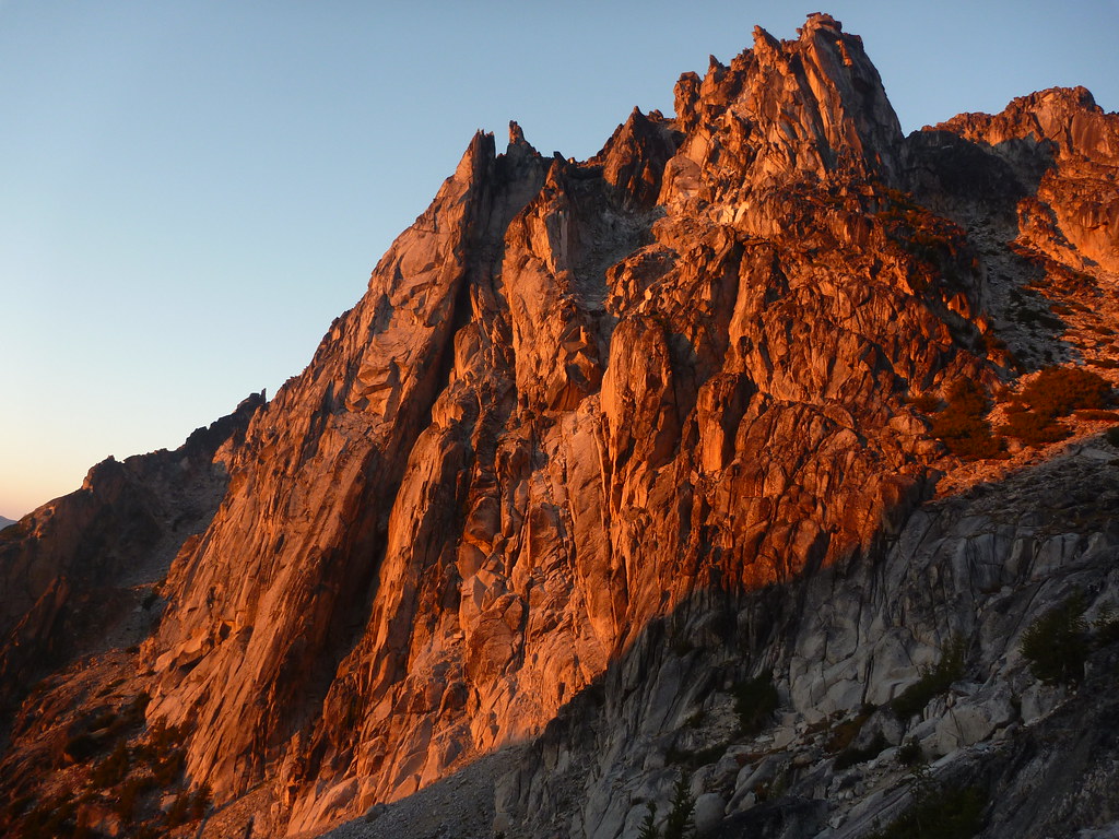
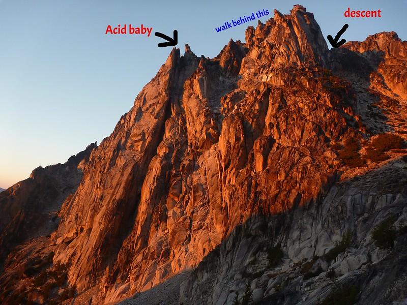 Acid Baby descent gully by Laurel F, on Flickr
(unannotated photo:
 )
) -
... along with some other random items.
yours? send me a PM, describe items, tell me where you got your hair cut in April, etc...
PS I used your bug spray, thanks.
-
Sure, wayne, go ahead!
-
For everyone who complains (or has been told) that Index is too hard... Here's my top sekret list of easy (5.9 and under) routes at Index. There aren't 50 but if you really only climb 5.9, these 27 should take you at least all day. I've only listed routes I've done, not a comment on quality of those I've left out (which include a lot of new routes and recently recleaned).
Lower Town Wall
Great Northern Slab (3p) 7
Pisces (variation for p2 of GNS) 7
Aries (5 short p) 8+
Sickle/Taurus (variation to Aries that skips the hardest pitch) 7
Or whatever, there are about 10 pitches that are < 5.8 that can be combined in various ways to make 3 to 5 pitch routes, just look at http://web.stanford.edu/~clint/index/gnslab.gif
Princely Ambitions (2 p) 9
Roger’s Corner (2p, usually link) 9
Godzilla 9
Quarry Crack 9
Country
Ultrabrutal 7
GM/HoC 9 or 10a
Private Idaho
Wet Dream 9
Magic Fern 9
Istanbul 9
Battered Sandwich 9
Senior Citizens in Space 8
Hag Crack 6
Upper Town Wall
Davis Holland p1 9
Lovin Arms p3 9+ (climb DHLA at 9 C1 or walk to the top and rap)
Inner Walls
Toxic Shock 9
Toxic Shock with Even Steven start 8
Corner Flash 7
K Cliff
Special K 8
CF Route 9
Go 9
(some of the 10- routes didn’t seem any harder than the 9s to me. some are easy to TR)
Lookout Point
Peanuts to Serve You 9
Rattletale
Rattletale p1 9
-
I don't really know the routes on J-burg, but here's a photo from the vicinity of the parking lot:
 There appears to be ice of some sort all over it...
 -
Trip: Mix-up Peak - The Misunderstanding
Date: 3/7/2015
Trip Report:
Original FA trip report from kurthicks: http://cascadeclimbers.com/forum/ubbthreads.php?ubb=showflat&Number=1039670
If you're looking for a moderate alpine ice route and you don't want to go party on Colfax with everyone else...
Sam, Alex, and I took advantage of unprecedentedly favorable alpine ice conditions for alpine ice at Cascade Pass. Sam bagged her first alpine ice climb, nice work!
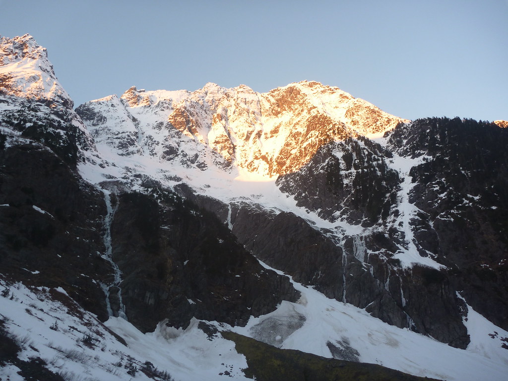
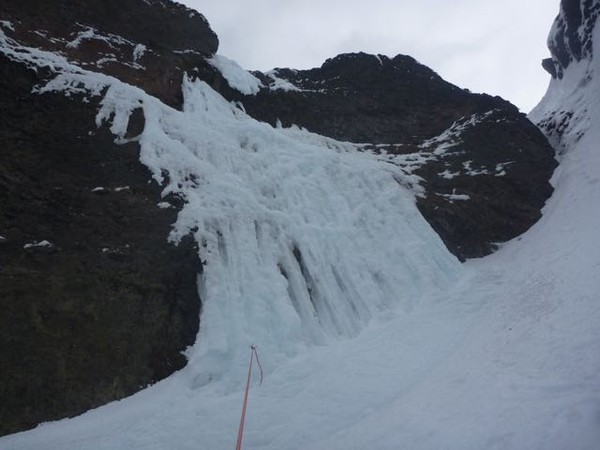
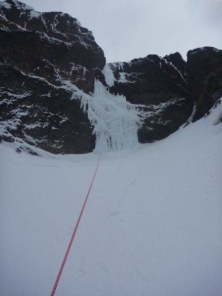
Someone had obviously recently been thinking the same thing, since there was a nice boot track already in (thanks!). Conditions are much fatter than on the FA, it's now about 3 or 4 short pitches of fun alpine snice and the rest snow walking. No mandatory mixed climbing unless you count kicking rocks while walking on the summit ridge. Here's some conditions-type photos:
The 'roof draped with icicles' is conveniently almost fully draped with thick if somewhat styrofoamy white ice.
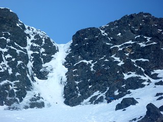
The fifth is still a bit steep for a short bit so I'm not going to particularly tell anyone it's not AI4, but definitely seems easier than it looks in the picture in the FA report.
More pictures: https://www.flickr.com/photos/laurelfan/sets/72157650858322510/with/16770708631/
Gear Notes:
Anchors take a bit of contriving. We took full advantage of having 3 people to carry gear and brought a dozen screws, single set of cams to #2, nuts, tricams, and a handful of pins, and used a bit of everything (especially pins for anchors). We definitely did not need that many screws seeing as how one of our party forgot that half of them were in her pack and just carried them up the whole route, and we still only placed about half of what we had out. The screws on the steeper pitch were not really confidence inspiring so I protected it mostly with rock gear.
Approach Notes:
Currently, the Cascade River Road is snow free and open to the 21mi gate, approach (winter route) is on crust and old avy debris from the parking lot to Cascade Pass. No flotation necessary. People are taking the summer trail but winter route is fast walking (cramponing maybe) conditions.
We had to make one 60m rap from a tree on the East Face descent, probably because it was dark and we went the wrong way.
-
Here's the gap:

For scale, it's two full pitches to get to where we bailed. Someone get on it and show us how it's done...
-
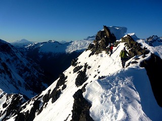
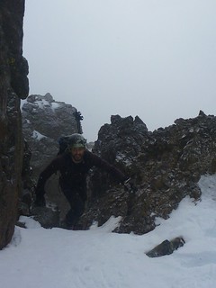
Thanks for having the crazy idea and inviting me along! Here's to going out and taking a look even if conditions probably suck, to tossing turnaround times in the garbage bin, and 3am (the most alpine of times).
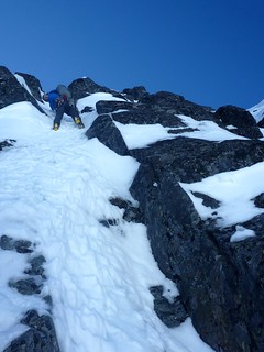
Here is a photo of Joe (who did not get the garishly colored jacket photography memo) in one of the class 3 rock/snice chimneys:
Snow traces the ways through the rocks by Laurel Fan, on Flickr
-
Here is your data to answer this and all other "What is the weather like at X in Y month" questions:
http://www.wrcc.dri.edu/cgi-bin/cliMAIN.pl?wa6898
Click around starting at
http://www.wrcc.dri.edu/coopmap/
to find data for a couple thousand other weather stations (one thing to watch out for -- the "Period of Record" is different for every weather station, so if you want to actually compare two different stations you need to use something like "Custom Monthly Listing" to set the same time range).
-
Sunchips looks like a good option (especially if camping at Colchuck and not wanting to carry a bunch of crap up Asgard):
http://cascadeclimbers.com/forum/ubbthreads.php?ubb=showflat&Number=838848
I haven't done it but have heard good things.
-
Beta spoiler request alert:
I also am confused by p5. Only thin at the start? Start meaning the first half? WTF am I supposed to do here:
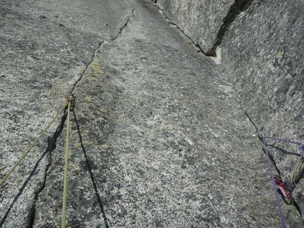
(besides start aiding)? Stem in the corner? Stem between the corner and the left seam? Is this move height dependent or being-terrible-at-slab-climbing dependent or spent-an-hour-falling-off-the-crux-pitch-in-the-sun dependent?
Still, awesome route, thanks for putting this up. The scoop pitch was fun, this pitch would have been fun if we hadn't started the route at like 1:30 meaning we did not have time to both hangdog the scoop pitch and mess around with aiding on a "10b" if we wanted to finish before dark...
-
Did you drop your watch on the scoop? The strap is broken (semi-obviously) and it's scratched but still works.
-
Last time I descended that way we ended up on a climbers trail down the Cascadian that intersected the Ingalls Creek trail 50 yards to descender's right of the Longs Pass trail intersection (so we should have turned left on Ingalls Creek trail). And yes, we blindly followed the Nelson beta, turned right and walked uphill unnecessarily for half an hour before turning around. If you end up getting in the trail there or anywhere else unusual you should be able to tell fairly easily from map and elevation (as long as you don't, say, neglect to recalibrate your altimeter at the summit because you are in a hurry to get down to the first water source you've seen in 24 hours and then not bother to look at the map because you've both been there before and the trail is so obvious).
-
I wouldn't say I've found the answer, but this is not exactly an answer anyway:
I think it depends on where you are, where you want to be. If, say, you currently climb 5.12 at the sport crag and 5.6 in the mountains, and want to climb alpine 5.10s, your weakness is not finger strength. However, if you aspire to 5.12 alpine routes then you should probably keep 5.12 sport climbing. I definitely see the people who FA'd the alpine routes on my wishlist "sport" climbing at Index.
My personal strategy has been to do as much alpine climbing as time, weather, and partners allow. I am not sure if this is the best way to progress (evidence would probably point to no actually
 ) but it seems to be a pretty good way to do a lot of alpine climbing.
Either way, when we have 16 hours of daylight and predictable weather, it's as good a time as any to figure things out, see some sunset summits, maybe test out that "emergency blanket"...
-
Do you know about the view feature in caltopo?
Here's the view in that direction from Snohomish:
http://caltopo.com/view#ll=47.9016,-122.0742&e=30&t=&z=7&c=-0.98,107.31
More info:
http://caltopo.blogspot.com/2013/06/summit-views-and-aerial-maps.html
-
I left some draws/slings at the bottom of Alpental Falls on Saturday. Yeah, after someone warned me that if I left my stuff under a rock I was going to forget it. If you happen to have picked it up and would like to return it, I would appreciate it!
-
This is a few weeks after that in December 2011:
http://www.flickr.com/photos/laurelfan/sets/72157628571844095/with/6573908257/
(looks... surprisingly similar)
-
Liberty Bell is in the new red book. In the link in my last post you can see a map of the area covered by the red book (though the boundary is not drawn all that precisely).
-
Are you only looking in the green CAG? Everything north of Hwy 20 is in red/Vol 3.
You can preview all the CAGs on google books if you want to see if it's what you're looking for.
It would probably be helpful to have the newer editions, given that the highway was not even finished until 1972. Unless you think beta is for suckers or something.
-
I've often thought that climbing skill is like cabbage in the refrigerator. Cabbage is best eaten fresh, though you can still use it up to about 2 weeks. After that, forget about it.
Remind me to bring some kimchi next time I see you
-
Attempted the DNB last weekend. We did not actually climb due to various factors, primarily rain, so I don't have that much to add, except...
Something that I have not seen mentioned in previous TRs is that we encountered quite a few yellowjacket/wasp/hornet nests (did not want to linger long enough for a positive ID). Most were underground or in rotting stumps in the wooded ridge section above bear camp (two appeared to be partially excavated. who digs up yellowjacket nests?? probably don't want to linger long enough to find that out either). One was hanging off a devil's club on the riverside "trail", which really ups the "worst approach ever" factor.
-
There is free and pay camping up the Middle Fork road (exit 34). It's FS land so free camping is even legal.
pay camping: http://www.fs.usda.gov/recarea/mbs/recreation/recarea/?recid=18034&actid=29
-
W Ridge of North Twin Sister (the one near Baker) is one of my favorites out of the scrambles I've done (well, my favorite that can be reasonably done in a day). It resembles some "west ridge" technical routes where you might be simuling on 3rd/4th class stuff forever because you are not sure when the 5.7 step will appear. Except there is no 5.7 here so you don't have that rope/rack/partner etc. weighing you down. I did not touch a single loose rock, which was a nice surprise (it was winter, YMMV).
my photos: http://www.flickr.com/photos/laurelfan/sets/72157628379870711/with/6495868625/
some beta: http://www.stephabegg.com/home/tripreports/washington/northcascades/northtwinsister
Here's a list with a lot of options:
Found shoe/socks, Snow Creek Wall
in Lost and Found
Posted
Anyone set your shoes/socks down in the vicinity of Outer Space? These ones? I hope your walk out didn't suck too much...