tradkelly
-
Posts
3 -
Joined
-
Last visited
Never
tradkelly's Achievements
")
Gumby (1/14)
0
Reputation
-
Olympic park traverse, Hurricane-Olympus-Hoh-Ruby
tradkelly replied to tradkelly's topic in Olympic Peninsula
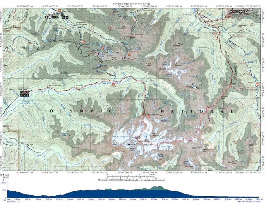
I'll take 'impossible' under strong consideration. I don't have a better map handy at this point; this is prelim research, mostly. The park's handout map is not particularly useful except for getting to the ends of a trail; figuring out a diff manner for crossing might end up as completely acceptable. I just took a rough TOPO plot for initial discussion. If that wouldn't go (and I'm learning more about Olympus reading what I can find in TRs here) we may look at an alternate. I'm definitely looking at something in the 50-80 mile range, but taking on offtrail ridgeruns and glaciers is VERY negotiable! I'm open to other suggestions for a fun-hard day, but make it as close to impossible as you can. Thanks for reading; the replies back so far are much appreciated. -
Olympic park traverse, Hurricane-Olympus-Hoh-Ruby
tradkelly replied to tradkelly's topic in Olympic Peninsula
Danke. We'd plan on doing this route in a day, yes; another ultra- type event, hopefully leave Hurricane in time to get to the start of uphill/offtrail climbing around Dodger Point at 0600 or 0700; that would leave us the morning to negotiate the ridgelines and put us around the glacier approaches from the east to Olympus by lunch or slightly after. Descent to the Hoh valley is problematic because it's not the typical 6k' glissade; we have to take decent care to get to the bottom in one piece, but quickly. Run steps down the glacier trail, if existant, or a moraine path if there is one on the western fringes. After that it's just a long flat grind out, possibly car-supported for light to the beach afterwards (I plan on asking a friend to crew and shuttle for us). Gear would presumably be trail running shoes, lots of extra socks, goretex booties for the alpine parts, and both strap-on cramps and yaktrax (or similar). Everything else in the pack would be food, camelback reservoir, spare clothes & waterproof gear, headlamps, filter, and tech axe. I'd guess that the crux of the route is timing for the glaciers; how soon to get there to avoid solid snow conditions on the north ridge and then the alpine bumps leading to Bear Pass and the Hoh Glacier, but still with reasonable crevasse and 'schrund conditions. Unfortunately, we'll be travelling and will have to either go for it (or not) when we get there, weather conditions notwithstanding. Things like knowing whether the rangers at Glacier Meadows will be present at that time of year, or if that's just a camp they sometimes visit - ?? I don't even know where to start (hence starting 8 months out asking questions). -
All right, I'm looking for some advice from you PNW local-types. Sometime next year, most likely mid-summer, I'm coming out there for an adventure run with my wacko People's Republic partner. I'm looking for your thoughts, your advice, and some local beta on when conditions might be suitable for it. I want to run from Hurricane Ridge to Ruby Beach, via Mount Olympus and the Hoh. Yep, all of the climate zones and conditions, from glaciers to rain forest. The proposed route is about 48 miles (inside the park, stopping at the Hoh visitor's center), 15,000' vert gain, net loss about 4,800'. Well, that's to Hoh visitor's center, and then tack on another 15 miles or so to the beach. I know what to prepare for in terms of weather (hoping for a weather window, of course) and general conditions for each discipline that we'll tackle (trail, alpine, glacier). I'm curious about a few things in particular. 1. When would be a good month, typically, to go for this in terms of maximum weather stability, lower precip odds, stable glacier conditions, and alpine snow cover dissipation? (The route climbs a N-facing ridge approaching Olympus.) 2. What should I look forward to on the glacier approach/descent as roughly shown on the map? We're both reasonably experienced and have proper gear, but really would rather not take rope gear - alternative suggestions are quite relevant and suggestions would be appreciated. 3. Is downclimbing the glacier towards the Hoh River on it's edge feasible, or should we reconsider routing? 4. Anyone bump into some recommended research resources for our planning? I am expecting the climber's guide to the park, 3rd edition, shortly, but other crossrefs would be very helpful. Thanks, all. Look forward to hearing from some locals. Please be nice. Cheers! tradkelly http://www.geocities.com/tradkelly