


iluka
-
Posts
295 -
Joined
-
Last visited
Content Type
Profiles
Forums
Events
Everything posted by iluka
-
I think there's reason for some concern here but not the alarm that some have raised in prior posts. It could be frostbite, but getting it checked out in the AM will be fine... there isn't much they're going to do at this point since you're fairly far out from when it started. This does need to be checked out by a physician, the sooner the better. A few questions. What were the conditions like when you were out. Were you on snow? Freezing temperatures while you were climbing? Did you have a harness that was on pretty tight and restricting arterial flow to your legs or perhaps limiting return from your veins. Did your feet get wet and stay that way for a while. The question someone raised in a prior post about blisters is a relevant one. Do you have any blue or gray discoloration now? Depending on what the answers to some of those questions look like, this could be frostbite. Sometimes, after frostbite resolves and the tissue rewarms, you can have a lot of pain that persists for a while. It's call neuropathic pain. There can be numbness and tingling associated with that as well. You can get similar sensations, however, from something like nerve compression. Although it's unlikely from the design of the harness, if you were sitting in the harness for long periods hanging on your rope, you may have developed some nerve compression that is causing the numbness and tingling. If this is frostbite, it needs attention. If your feet have already rewarmed, as it sounds like they've done, that's about what you need right now so I wouldn't rush to the ER this very second. There is nothing else they would do acutely, although there is some talk in the literature about using antibiotics to prevent infection in some cases (althought without blisters, I don't think this is usually done). Don't let your feet get cold/frozen again in the interim. I agree with the previous post about not smoking. I doub the aspirin will be of much use. It prevents blood clots by blocking platelets from doing their job but that doesn't play a role in frostbite so it doesn't offer you much advantage here. Instead, take a good dose of Ibuprofen... 800 mg every 8 hours for a few days. Andy
-
I was up in that area in the fall. Big Sandy Lake is only a 5-6 mile hike from the Big Sandy trailhead with minimal elevation gain along the way. Shouldn't take more than 2-3 hours to do, although maybe a bit longer with full packs and gear and if it's hot. Camping there isn't a bad idea because of the altitude issues. The next morning it would take a few hours to get up over Jackass Pass. Someone in an earlier post suggested doing an alternative route to get up over the last pass into the Cirque. While it is certainly an easier route, this area gets so much traffic each year that it's probably best to just stay on the main trail, minor routefinding and minor extra altitude gain issues and all.
-
If you're one of those types that salivate at the thought of doing the east ridge of El Dorado with it's nice exposure, there's a nice peak up in BC with a similarly great ridge run. Wedge Mountain... up near Whistler. We were up there last weekend and had a great time. Great, long ridge run along the North Arete that leads to a pretty summit. And... if you find yourself missing the steep approach on El Dorado, you'll feel right at home on the steep 3,900 foot approach to the base camp area at Wedgemount Lake.
-
Climb: Wedge Mountain British Columbia-North Arete Date of Climb: 6/26/2005 Trip Report: Set off with two friends to climb the North Arete of Wedge Mountain at the end of June, 2005. We hiked up to Wedgemount Lake on Saturday. Trail the entire way and, boy, is it a butt-kicker with full pack and mountaineering gear on one's back. 3,900 feet up in 7km with only a few, short flat sections along the way. The trail is pretty rutted out with lots of exposed tree roots and rocky spots just waiting to twist an ankle here or there. There are occasional spots early in the season where one can fill a water bottle or two. The reward at the top of the trail make it well worth it as the views of the lake and the surrounding peaks are quite magnificent, particularly in the low, late afternoon light. Somehow, on the way up the trail, though, that doesn't seem like such a high priority. There's a small, spartan hut at the lake with room to sleep perhaps 8 or so and space to stash gear while off on the climb. There's also a toilet, which, surprisingly given the large pile of you know what underneath didn't smell that bad! There are several small ponds with water near the hut but if you're looking to avoid boiling or risking Giardia, early season there are many streams draining from the ridges above the lake which provide a nice, clean water source. The next morning, we were up at 4AM and off for the summit by 4:45. In hindsight, given the changes in weather that occurred, a 45-60 minute earlier departure might have been better. We headed around the north side of the lake to the terminus of the glacier. There's a faint trail out that way from the hut but if you don't find it, it's no big deal as the route is self-explanatory. A 20 minute walk brought us to the morraine at the end of the lake and right to the foot of the glacier where we opted to rope up. Crampons were necessary as the bottom of the glacier was firm ice with no snow on it. We hit snow after only a few minutes of walking up the easy slope onto the glacier. Crevasses were visible but were barely open at this point and easily crossed. We had been told that is not always the case as my partners knew or had heard of people who had fallen in to their waists in the past. As we got out onto the level part of the glacier we saw the two options for gaining the ridge that comprises the North Arete. It is possible to work high up on the glacier and climb a steep snow slope that puts you on the ridge about 2/3 of the way along its length towards the summit. We were intrigued by what we had heard about the ridge run and opted to do it's full length instead. We headed up the wide, less steep snow slope to our left lower down on the glacier. Rather than going all the way to the top of this slope, we traversed to our right and headed up a short gully that led to the ridge proper. This stretch was a bear as the snow was very soft and Paul, out in the lead, was constantly breaking through as he put in steps. Out on the ridge itself, we had a view of the entire route. Two things strike one at this point: (1) It's still a long way to the summit and (2) there's a lot of exposure on both sides. We opted to stay roped up for the ridge run, prepared to jump off the opposite side if one of us fell. Most of the ridge was covered in snow, although there were a few short sections with mixed climbing on snow and rock -- always fun in crampons. Fortunately, there wasn't too much ice as that would make that ridge an unpleasant experience at best. The snow was soft enough that we could get in very reliable steps, perhaps a bit too soft, in spots however, as the second and third people were often breaking through. We spent sometime on the east side of the ridge and some time on the west side... it's easy to tell when to be in what spot. It took us perhaps a bit more than an hour to do the bulk of the ridge and get to the bottom of the steeper portion up to the summit ridge. From afar, it looks pretty steep an unappealing but once at its base, the slope didn't appear too bad after all. We had good snow for making solid steps. Still a lot of exposure at this point and no good runout if you happen to fall on this part. Had the snow been firmer, we might have opted to place some pickets but with it being so soft and our footholds so good, we decided not to do so. After 30-45 minutes we were on the summit ridge. From there, it's a 100 m horizontal distance walk to the summit itself with perhaps 10m of elevation gain, if that much. We arrived just in time for the clouds to blow in from the south and take away the view. We wasted all of about 2 minutes on the summit itself before heading back down to where we gained the ridge to pick up our rope and grab some food. Some books say you can descend the North Arete itself but in the whiteout, that didn't look very appealing. Nor did the prospect of going back along the entire ridge itself before dropping off the glacier. We decided instead to descend the talus slopes on the west face of the peak. Hard to give a great description here as we were in a whiteout most of the way. We followed the talus slope down to about 7700 feet and then traversed to the right where we eventually came to a saddle -- or so it seemed in the whiteout. Try to avoid heading too much to the north or sticking too close to the west ridge itself as this can take you into some steep, gnarly terrain. Around 7700 feet, we were fortunate to pick up some foot prints and followed these in the snow. We dropped off a steep snow slope to the northwest before it levelled out after 20m into a basin which we followed to the north. Crossing alternating snow fields and talus fields, we eventually made it to the broad saddle that sits between Wedge and it's large neighboring peak to the west. The saddle is easily seen earlier in the trip when you start ascending the glacier. From here, it was an easy trip down the glacier to the lake and back to camp. A bit of a break there and then 3,900 steep feet back to the car. Time to summit: 4 hours, 45 minutes from the lake (slowed by soft snow and a lot of step kicking in a lot of spots). Car to the lake will take 3-4 hours with full packs, less with a day pack Descent time from summit to lake: 3 hours Lake back to car: 2.5-3 hours Gear Notes: Helmet Axe Harness Crampons Rope Pickets (one apiece) Approach Notes: Trail: 7km, 3900 butt-kicking feet up steep, rutted trail
-
It sounds as if you've thought about the altitude issues pretty well and know your personal tolerances which is the key. Also sounds like you know what you're looking out for in terms of symptoms and that will help too. Descent is always the best plan if someone has symptoms and the fastest way to resolution but in case you get nailed by weather and can't descend, will you be carrying along some Diamox or Dexamethasone? While you are right that acclimatization doesn't occur in terms of hours, it doesn't take weeks either. It's generally something that happens over a period of days at a given altitude. In fact, if one stays at the same altitude, the risk of HAPE goes away after about 4-5 days. You are also right that altitude illness generally doesn't happen below 8,000 feet. There is, however, a series of cases published out of France recently that described a series of recreational skiers who developed HAPE at altitudes below 8,000 feet. Best of luck with the climb.
-
Uhh... yah... HAPE and HACE can definitely occur at 14K in unacclimatized individuals. HAPE has actually been reported quite often in the medical literature to happen at altitudes as low as 8K feet. In fact, it's a not uncommon problem where you live when people commonly fly out from the east coast and find themselves on top of Vail or Aspen the same afternoon. HACE usually occurs at higher elevations but can be seen at 13K. I agree with the other point that crazy t made that some prior acclimatization will go a long way towards making this a moot issue. A few climbs to higher elevations in the days leading up to the 17 hour ascent will help as would a night or two sleeping at higher elevations. The other thing that's important to remember is that the response to altitude varies dramatically between individuals. While one person may be able to bop up and down to 14K at will with no prior acclimatization and have no problems, other people going to the same elevation at the same ascent rate may get really sick. So... just because because you have no trouble going to 13K is meaningless for others planning their own trips. You have to know your own tolerances. Finally, being in good shape doesn't protect against altitude illness. It helps you do the physical work of lugging you and your pack up the slopes when not much 02 is around but it doesn't protect against getting one of the altitude illnesses.... much as we wish it would.
-
HAFE is really only an issue for those in back of you on the rope so no big deal there. I disagree with the argument that 9-10 hours is too short for HAPE or HACE to occur. I've been involved with chamber experiments on high altitude physiology in which subjects have been exposed to breathing air that's the equivalent of 13,000 feet and within as little as 4 hours several of the subjects had symptoms of severe AMS which can easily progress on to HACE if someone continues to ascend. HACE and HAPE are definitely more likely with greater time at altitude but they can happen in short periods with very fast ascent rates. HAPE has been seen as low as 8,000 feet and even lower in some case series in the medical literature. Throw in the heavy exertion associated with a fast ascent and the risk of it occuring on an ascent like this is real. A small risk, but not non-existent and, I think, should not be ignored for the sake of a "fast summit" especially if it puts others at risk trying to rescue one's butt off the mountain when sick.
-
Do you have any experience with similarly fast ascents to such high elevations? If you've done it safely before, it's worth a go. Otherwise, I think you and/or your partner are begging for some form of high altitude illness, either acute mountain sickness, High Altitude Cerebral Edema or High Altitude Pulmonary Edema. Some might counter that statement by arguing that by going up fast and getting down fast the risk for any of those occuring low. I would disagree. Even moving at a good clip, you'll be spending enough time above a sufficient elevation that any of those problems might occur. The heavy exertion you'll be doing will also further increase the risk of HAPE. Finally, being in good physical shape is no protection against these problems. The altitude doesn't care how fit you are or how motivated you are. If you're still keen to go ahead with this plan, I'd make sure you know very well what symptoms and signs to watch out for and be heading down at the first sign of them.
-
While the age issue, self-aggrandizement issue and all the other stuff everyone is discussing above is interesting... I want to know if the Ritalin has any effect on her ability to perform/adapt to the high altitude
-
Came across this great website today (which I'm sure many of you may have seen already) with information on tons and tons of peaks throughout the U.S. and around the world. Seems to have some good basic route info and lots of trip reports. Great photos as well. The address is: http://www.summitpost.org/
-
As of May 7, conditions are pretty good on the route. Just did it today. One can push or ride their bike from the parking spot all the way to the start of the ridge climb at 4,100 feet. The ridge is essentially free of snow and ice. The north face descent is covered in snow -- pretty soft and easy to downclimb and plunge step in at present. Not very deep coverage, however, so not clear how long the descent route will stay good.
-
Were you able to mountain bike up the road past where you parked or did you have to snowshoe or ski it?
-
Anyone been up in the area of North Twin Sister lately and have any idea what the road access is and how conditions are on the peak? Thanks!
-
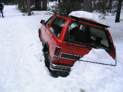
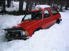
Unfortunately, the Chevy Blazer, often referred to in previous postings has been broken into by some lowlifes. See the attachment for photos). We passed it on our aborted trip last weekend and the back window was smashed. It and the road are also quite deep in snow and it's unlikely it's coming out for a few weeks.
-
For those interested... as of 4/23, if you have 4 wheel drive or high clearance you can get to 1-1.25 miles from Morrison Creek CG which puts you about 4+ miles from the trailhead. Without the above type of transportation, there is a short, muddy, very rutted out section a few miles lower that may stop you. Perhaps the rain this weekend -- quite wet down there on Saturday -- will improve things but it may be a few weeks away from driving to the trailhead.
-
The CDC website is the best place to look to see what vaccinations you need for a particular country. Most people who work in travel clinics will refer to this site when deciding what to give you for your trip. If you will spend time in the Amazon, having along malaria proplylaxis is a good idea. Some of the meds (Larium and Malarone) are very expensive and may not be very cost effective if you're not sure you're going to visit these areas. A useful alternative is Doxycycline which is effective and much less expensive. The downside is you have to take it for one month after you return and some people get skin reactions when they take it and are exposed to the sun (photosensitivity reactions). Diamox and Dexamethasone are both good ideas if you're going to be bopping around in some of the high altitude regions of the Andes. Both are very inexpensive and well worth having along... provided you know how to use them.
-
Anyone been down to Mt. Adams lately and know how close you can drive to the trailhead for the South Spur route? Thanks
-
I'm not sure I agree with that assessment of the state of things in Nepal. I spent the entire fall of 2003 working up in the Khumbu Valley. The area above Lukla was and is still safe as the military has made a big effort to keep the Maoists out of the valley. On the trek from Jiri to Lukla, however, trekkers are encountering Maoists who demand extortion money (a "donation" as they put it... but, hey, they give you a receipt) for you to pass. Fly into Lukla and you can avoid all of this. At the time I was there, there was no word of them roughing up Westerners although that might have changed since then. There were reports of bandits in some areas posing as Maoists and roughing people up. They don't have an easy time picking out Americans. For starters, few of the Maoists speak English and they generally can only communicate with the Nepali guides. If you want to avoid problems, sew a Canadian flag on your pack. Don't take along your passport. Instead, try to borrow a Canadian friend's passport and make a photocopy of it that has your photo in it instead. The Maoists have a lot of anti-American rhetoric, which is why the State Department has put out a travel warning, but they're not up in the Khumbu Valley and that area is still safe for travel.
-
Anyone tried to go up Baker recently or have any idea how far up the road one can get to the trailhead for the Coleman Glacier route. Any idea where the snow level is at?
-
A friend of mine who is an excellent guide is looking for some people to join him on an attempt on an unclimbed peak in the Everest region of Nepal this fall. The peak's name is Nirekha. It is located near the Cho La, the pass that sits between the Gokyo and Khumbu Valleys. If you're interested and available, drop me a line at andrew_luks@yahoo.com and I can put you in touch with this person. Thanks.