


Ponzini
-
Posts
221 -
Joined
-
Last visited
Content Type
Profiles
Forums
Events
Posts posted by Ponzini
-
-
"Lindler's Schist"
-
Climb: Tantalus-North Ridge
Date of Climb: 7/1/2004
Trip Report:
Yeah, I know, this TR is really old, and I apoligize for the poor photo quality (supermarket point & shoot). But it’s a good yarn and it might encourage some people to go climb Tantalus who wouldn’t otherwise want to mess around with canoes, locked cable cars or choppers – all you need is some fitness! It's a great 3 day trip and is technically quite easy (PD+ or AD-), but it's strenuous. Going in August or later would likely involve some big schrund and/or moat obstacles and would be slower...
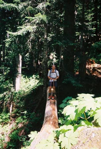
Our plan was to take the Canada Day weekend (same as 4th of July) and go up the Sigurd Creek trail, climb over the shoulder of Pelion, camp somewhere, climb Tantalus via the North Ridge, and come back in three days. The Sigurd Creek trail is in good shape and takes you into the rugged and pristine Sigurd Creek valley.
High and Slippery!
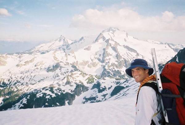
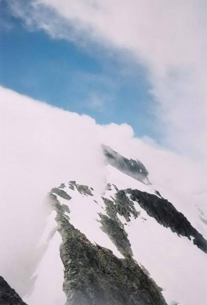
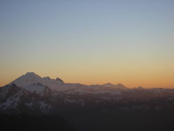
A long and hot climb up to the 7000 ft pass on Pelion’s shoulder gave us our first view of Tantalus. Camp was on the ridge just left of DJ's nose (summit under cloud):
We enjoyed the view and rested before hurrying down to a fine campsite at the head of Mawby Creek. We found flat ground and good water, and enjoyed the sunset after 11 ½ hours approach.
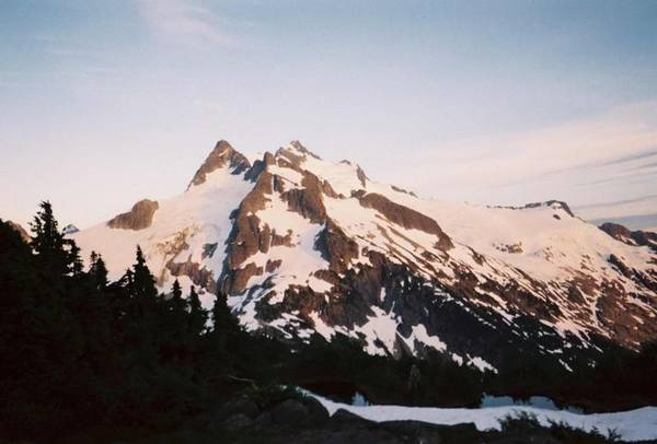
Tantalus from Camp (right hand summit)
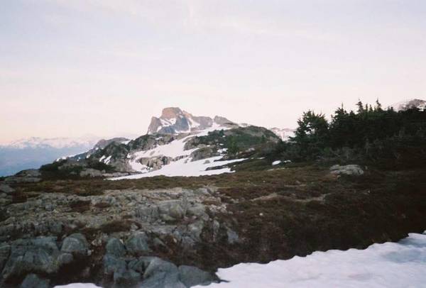
Zenith from Camp:
Next morning – up at 5am – and cloudy. The forecast said showers…..but we could see to the top of Tantalus…..let’s go! We followed the ridge south from Pelion, and soon had to deal with 300 feet of steep downclimbing on heather, moss, and shitty rock. We soon got past this section and followed the ridge as the clouds slowly dropped. A long trudge up easy snow slopes brought us to a 6300 ft col and the start of the north ridge proper.
At this point, one can climb directly up the rock (slow) or ascend snow to the western side of the ridge. We close the latter, since it was much faster, and we now had the tracks of a trio of other climbers to follow. These guys had flown in the evening before to the north col, and were about 2 hours ahead of us. 500 feet of 45 degree snow above a large bergschrund brought us to a sharp gap, from where we could see the western glacier below and nothing but whiteout above. Another long snow trudge up into the whiteout put us onto the crest of the ridge, at about the 7000 foot level. As it was now raining, we ducked behind a cornice to warm up and rest. At this point, things looked pretty gloomy, but, in about 30 seconds, it cleared off and a huge patch of blue sky appeared!
The ridge quickly clears:
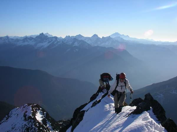
We dashed out of our hollow under the cornice and got a glimpse of the ridge ahead. From this point on, we climbed on a long stretch of superb ridge, easy climbing but exposed. If it wasn’t whited out, the views must be awesome – straight down to the Rumbling Glacier to the left, and steeply down to the western glacier on the right.
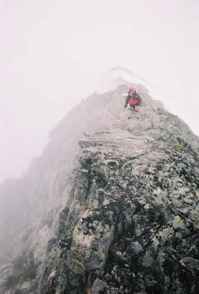
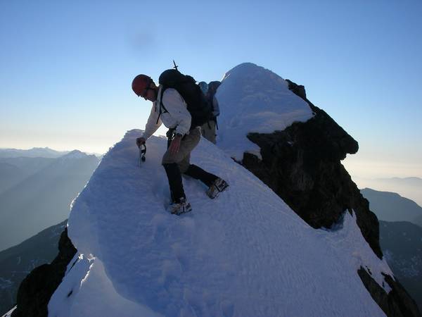
Typical North Ridge scrambling (taken on way down):
Eventually, we dropped slightly and found ourselves at the head of the Rumbling Glacier. What now?
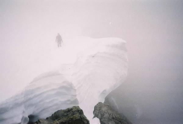
We couldn’t see much in the whiteout, and nothing looked very easy. We climbed steep rotten snow up to the rock and I headed up into the muck, but after 50 feet I gave up on the loose, greasy mess. We ignored the tracks of those ahead of us, who took a very poor-looking line, and we traversed out left to try and outflank the mess. A nice lower angled section appeared out of the mist, and although loose, it led to a steep snowslope. As I climbed the snowslope in the whiteout, it felt a little unusual – I realized just in time that it was not a snowslope, it was a big tilted cornice and that we must be on the summit ridge! We traversed the cornice, turned the corner, and found excellent class 3 scrambling on steep and solid rock. Derrick’s altimeter read 8400 feet, meaning that we must be close.
Big 'ol cornice
I topped out on the mini-face we were on, looked around the ridge, and there it was – the top! 50 feet of steep rock remained. It would be easy when dry, but the rain had turned the black lichen into ice. We got the rope out and I tested and then clipped an ancient fixed pin - Some delicate moves with big exposure brought me to a good belay, and when we topped out, we saw the actual summit peering through the mist at us, only 15 feet higher and across a small, sharp gap. We surprised the party of three, who we’d caught up to, and who were in the process of rapping down from the gap. There was a lot of loose rock on both sides of the gap, and it was raining again. I was very concerned that we’d knock rocks onto the three below us if we’d gone into the gap – the other group was concerned about this too, as they pointed out several large loose rocks that they said were unavoidable. Given the weather, the time, and the length of our approach, we were elated to get within 15 feet of the summit. We shook hands and rapped off.
We reversed the entire route, which went smoothly. The whiteout relented once or twice, enough for a few restricted views. The endless snow trudge from the way up was now a quick glissade. Climbing the 300 feet back up the heather and grass step in the ridge to get back to camp was tough, as all the rock was loose (the vegetation was most secure) and it had been raining for a while:
We finally threw our packs into the heather and crawled into the tent 15 hours after leaving.
The next day, we slept in and got a leisurely 11am start. On the descent back down to Sigurd Creek, the snow was a blessing and it didn’t take long to glissade the 3000 feet back down to the trail. The cool and cloudy weather was very welcome as we hiked out, and we met several day hikers along the trail, who asked if we had been “camping” and what snow pickets are used for - we politely answered their questions and had a nice walk out.
-
The scenery and the general story are great, but the dialogue is a bit much:
“Mountaineers know that death is a constant companion on every climb” etc.
It`s also a little disheartening to watch rich hikers try to be high altitude mountaineers...but it`s still worth a watch!
-
PS Sorry about the width thing - no idea how that happened!
-
Climb: Welch Peak-South Ridge
Date of Climb: 11/11/2004
Trip Report:
Went up Welch on Rememberance Day (AKA Veterans' Day) to dust off the winter climbing skills. The Williamson road was easy for a 4X4 and the slog to the lake was snow-free. I started bonking halfway up the ridge - must have been that nagging cold that I was trying to get rid of by spending a rugged day in the hills. FYI, physical exertion in cold, dry air is not a good cold remedy. The ridge wasn't in winter condition due to the recent rains and sun, but there was enough snow to make things more challanging than summertime. However, roughly 50m below the south peak, I well and truly bonked and was getting some harsh dizzy spells. I sort of remembered that there was no good descent off the north side of the south summit, but wasn't too sure - in the end, we traversed some loose slopes and found some good hard snow to downclimb towards the Welch - Foley col - glad we brought crampons! It was totally dark once we finished this, and the rest of the walk out is just a hazy memory from my semi-coma state. Do I feel like going back for the winter? Ask me in a few months.....
-
Up in Canada, eh:
(All not too hard)
West Ridge of Rexford
South Ridge of Welch
East Ridge of Joffre
Although these are all ridge climbs, there is still some avalanche danger on the approaches, especially Welch. Just don`t go winter climbing after big dumps or when it`s really warm (since you`ll be postholing anyways!)
-
I use the Garmont G-Lite. It's very light and comfy, which is the most important thing for touring. Stiff boots are usually too clunky and heavy for touring, they're only good for skiing yo-yo runs adjacent to a resort. Go light and use your skiing ability to compensate for reduced boot stiffness. I've skiied some hard terrain with the G-Lite and they offer plenty of performance for the backcountry - but you can't bang gates with them!
-
Yeah, you're right, I guess it is the west. Overall it's not a bad scramble, although it's loose. My dislike for it really comes from the fact that I pulled a large block that ground across my hand and blackened three fingernails (and I was lucky!)
-
East ridge of Welch - downsloping greasy rock with lots of crap on the ledges. South Ridge is way better.
North ridge of Knight - If you like long approaches to loose and sketchy scrambles, this one is for you!
SW ridge on Larrabee - Only bad if there are other groups on the route. All groups go through the same narrow gully down low - and due to the angle you can't see the narrow part from the top, and vice versa. Lots of loose stuff guarantees rockfall...
East ridge on Tricouni - only bad if you've carried a rope 'n gear all that way. Confident scramblers will feel cheated.
-
Warren did a slideshow at the BC Mountaineering Club social on Tuesday - it was fantastic, standing room only. He had a video of him following some grade 5 ice in the Rockies with these specially made crampons - wild.
-
I thread my hexes with spectra cord - slings are too bulky. The spectra cord has come in handy from time to time to sling the cord loop over micro-horns in sticky situations where there is no other pro. Couldn't do that with wires....
-
And how would ski access be? Could you ski up into the valley you camped in? Looked pretty steep.....
-
Thanks for the info....I had my eye on Foley's NE ridge, couldn't find anything in the guides, but it looked interesting through the binocs from Conway. Only one way to find out!
-
Climb: Splitter Granite in the Cheam Range-
Date of Climb: 10/2/2004
Trip Report:
Lowly Conway Peak is composed of some type of granitic rock, easily distinguishable from the poo-brown rock that a lot of the Cheam Range is made of. It's a very pleasent hike, take the Lucky Four Mine trail from the southern end of the highest switchback of the road that leads down the east side of Jones Lake. With some clearence, you can drive to about 2500 ft. When the trail breaks into open meadows, head up - it's very obvious. The upper west face of the peak features several enticing (but short) cracks, I chose a nice 4th - easy 5th line that spiced up the last 200 feet to the top. Some of the cracks on the face look comparable in quality to the Lower Malamute - however, it's a 4 hour walk to get there....
I made the trip mostly for a look at the winter access to the north sides of Foley and Welch. Looks like excellent access via skis, as long as the road is drivable. Foley looks like a good winter objective from the north. North Face of Welch looks awful, which I expected since it looks awful looking down it from the top. Anyone know if it's been tried (or climbed) in winter??
-
Agree with Rad. You seem to have an overuse injury, for which the only treatment is not to use it. I chipped a bone in my ankle in a lead fall, and while doing nothing sucked, it was 100% after about 6 weeks.
-
If you move to Winnipeg, you may want to take up buildering to satisfy your climbing urges - www.buildering.net
-
Cool vid, Dru. Very humbling for those of us that take whippers on 10a
-
For basic use (ie rescue purposes on glaciers), go for the sale! Express handles are nice but not really needed on easy ice, they're more for leading steep water ice. Omitting the express handle will same a small amount of money and weight.
-
I climbed a much more enjoyable (and sporting!) line that goes up from the "P" in "Pierre" in the photo. It's more direct, is cleaner, is more exposed and is way better climbing than linking up bush ledges. The crux was in the grooves above "Pierre", don't remember the exact line, but it was easy 5th at the bottom and 3rd-4th afterwards. From the roadblock, it'll take between 9 and 11 hours return, depending on your speed. Rapping is easy, one 50m rope is OK.
-
Too Drunk to Fu*K (back of the Chief)
Bailing from a rock route
in Newbies
Posted
I hope that fatigue wouldn't be the problem that makes you retreat from a one pitch route!
But I'd say leave nuts or hexes, why leave cams, they're the big $. They can also be confidently wedged into place so that in a nice crack, only one will suffice (although two is safer).