


kurthicks
-
Posts
2565 -
Joined
-
Last visited
-
Days Won
2
Content Type
Profiles
Forums
Events
Posts posted by kurthicks
-
-
Sorry to miss it. Next time!
-
Standard Brewing in the Central District?
-
Sorry to miss it! Lots of familiar faces in the crowd.
-
 1
1
-
 1
1
-
-
That terrain is meant for skis! Looks fun.
-
 1
1
-
-
I lost a Black Prophet up there about 15 years ago--I can't remember if it was a carbon or an aluminum/rubber one though. Not much of a tale to tell--it fell off somewhere and I had to use a skinny rock to dagger my way up the glacier. Who knows how many tools are lost up in the park!?
-
There is a climbers trail through part of your purple line. Walk to the end of the road, near some old logging equipment, and dive straight downhill into the big trees. Cross the creek and veer up and right. Look at the satellite image for big trees, then the meadows once you gain the ridge. It's not that bad by Cascade standards.
-
I think that's Calvin Klimb
-
Time flies, doesn't it. Glad that you're making it happen out there!
-
I don't know if anyone has guided it yet, but only a couple businesses hold permits in the Middle Fork. I don't mind the tree pulling either, but it certainly does detract from the route IMO.
The route is a scorcher too -- definitely one to best do on a cloudy day or super early in the morning.
Thanks for the kind words; glad you're enjoying the book!
-
Glad folks are getting on this. A few notes:
Yes, there is an error in the rack description. A single set to 2-3" is sufficient for most leaders.
The old bolt down low on the route was deliberately placed by the FA team as a bit of a joke.
The pitch 7 corner-to-tree pitch didn't exit right onto the slab since that slab is an exfoliating piece. There is talk of trimming the branches and perhaps adding a short fixed rope instead.
-
10 hours ago, JasonG said:
Yeah @kurthicks, let's hear about your brush with fame.
I guided a trip last year in the Ruth Gorge for The North Face. Alex was there and we spent some camp time talking about climbing in Washington--he's been out to our crags and said he'd definitely be here again. So I got in touch and had him review the book. He's super nice and it was great to connect about our local terrain!
-
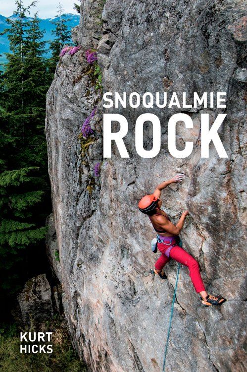
The Snoqualmie Rock guidebook is now available for pre-order. Visit www.snoqualmierock.com for more information.
-
1
-
-
Hey CC.com!
I'm proud to announce the release of Snoqualmie Rock. After 5 years of research, writing, and review, this comprehensive guidebook for the I-90 corridor is finally complete. It covers well over 700 routes from Issaquah to Snoqualmie Pass at over 60 crags. You'll find it in stores this June, but you can pre-order your own copy now at www.snoqualmierock.com
See you all at the crags!

-
3
-
3
-
-
I have a big Fish haul bag that I'd let go for $60. I think it's the Grade V. Old, but in good shape.
-
Friends climbed the full ridge 2 days ago. Snow on the slab pitch and in the notch above the Gendarme. Steep snow on the descent by the False Summit.
-
FYI: The North Ridge is often climbed into September, when it's iciest.
Personally, I'd give it a month for things to consolidate and melt off a bit before going up there. Otherwise it's a whole lot of slogging for about a rope length of ice climbing...
-
If you're up to the grade, just go give it a look! I'd hate to spoil your onsight!
-
The pitch directly above "I Wanna Go Home" is called "Sleep or Awake" 5.10c, 7 bolts, 50 feet. The single biner is a bail biner...the route goes to the top.
There is also a route further right on the headwall, "I Can Fly" 5.11c, 7 bolts.
And the new book is coming very soon!
-
Is it easier to access franklin falls from the ski resort area? Or is better to just on the normal road to the trailhead?
Park at Summit West, cross under the overpass, and ski down the closed Sunset Highway. 10 minutes easy downhill!
-
Sounds like NBC might be be a good ski right now
Bony. We passed on it today. Good climbing shape though!
-
just came back from Snoqualmie Pass.
Basically everything is still in: Kiddie Cliff, Bryant Buttress, Rap Fall, Chockstone Falls, etc. No word on Franklin Falls.
There is about a foot of new snow over a very stout rain crust, making travel relatively easy.
-
FWIW one can cut climbers right out onto the slide path before this snowy talus field and with some low angle scrambling gain what I think was the bench that you started your P1 from. This provides a nice view of the route and avoids the talus field and treed rib.
Thanks Jake. We skipped the direct approach since it didn't look like there was enough ice on it to make it go. Glad to know it worked for you!
-
I did this thing yesterday: http://cascadeclimbers.com/forum/ubbthreads.php/topics/1153020/TR_Middle_Fork_Peak_3964_False#Post1153020
Too bad the warm up is coming on Monday!
-
Trip: Middle Fork, Peak 3964 - False Idol, WI3+, 500m (FA)
Date: 1/6/2017
Trip Report:
On January 6, 2017, at the end of a prolonged cold snap, I established a long waterfall ice route on the NE face of Peak 3964 in the Middle Fork of the Snoqualmie River valley with Dave Jordan. Our route climbs two tiers of ice, separated by a few rope lengths of snow covered waterice and snice. The first 200 meters is classic waterfall ice climbing, while the upper bits have more thoughtful protection akin to our local alpine climbing. All told, it is reminiscent of Guinness Gully in the Canadian Rockies. We found the route to be very worthwhile and not overly committing--given the bountiful rappel trees on both sides of the route.
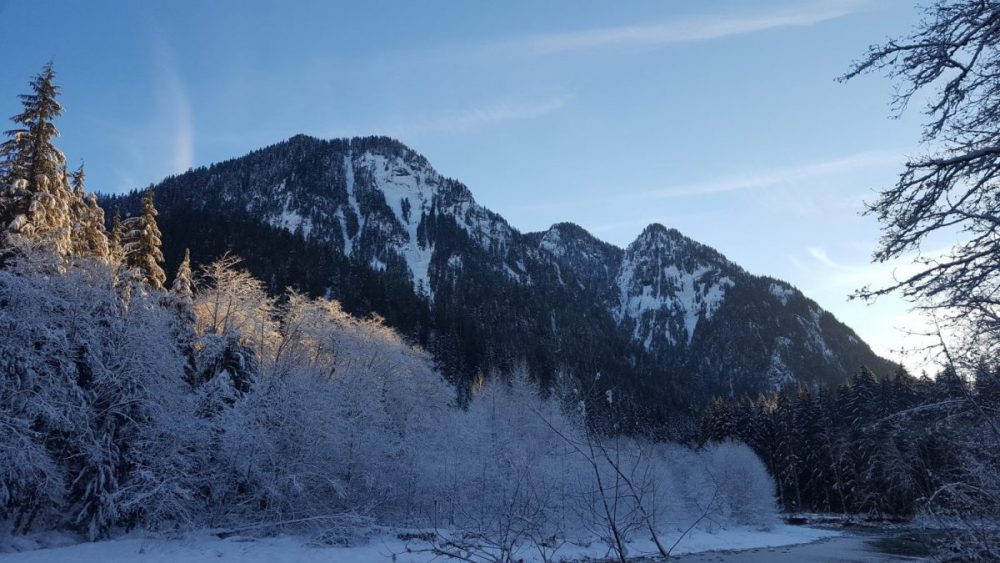
Peak 3964 (left) and Revelation Peak (right). The route climbs the right side of the Y-shaped clearing.
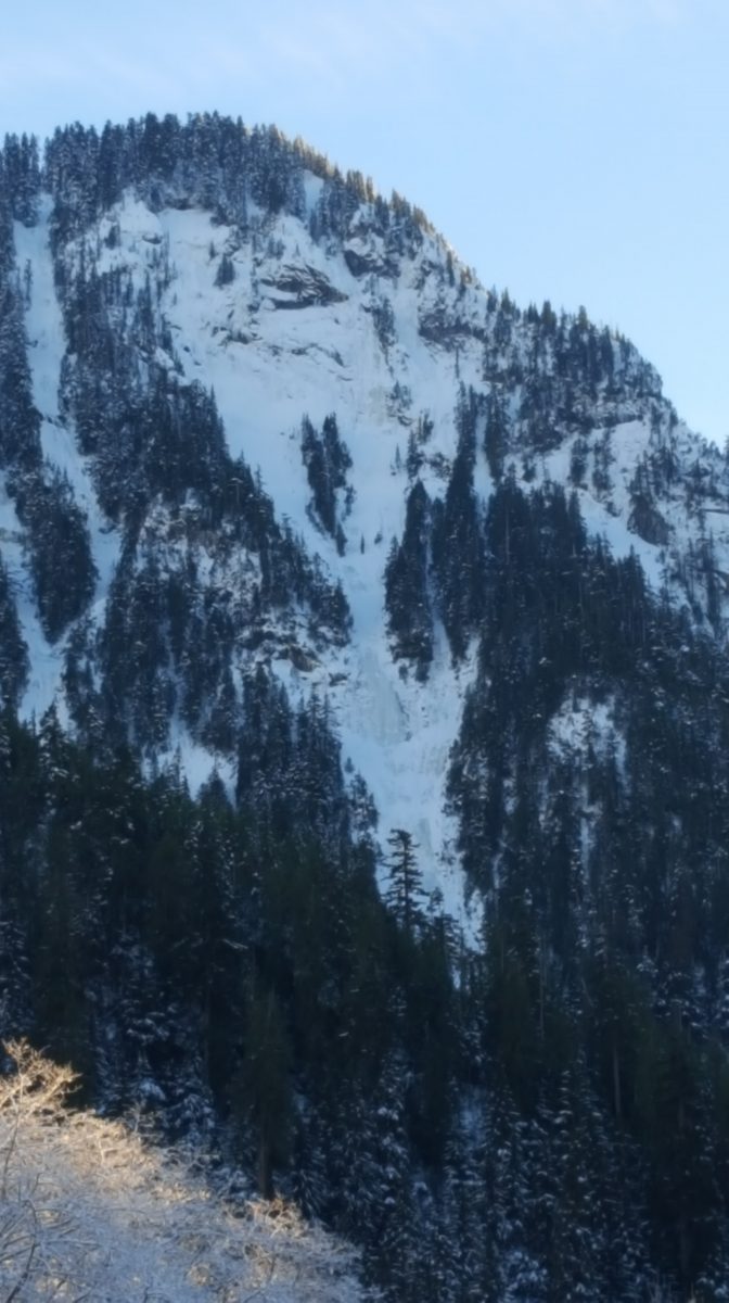
False Idol
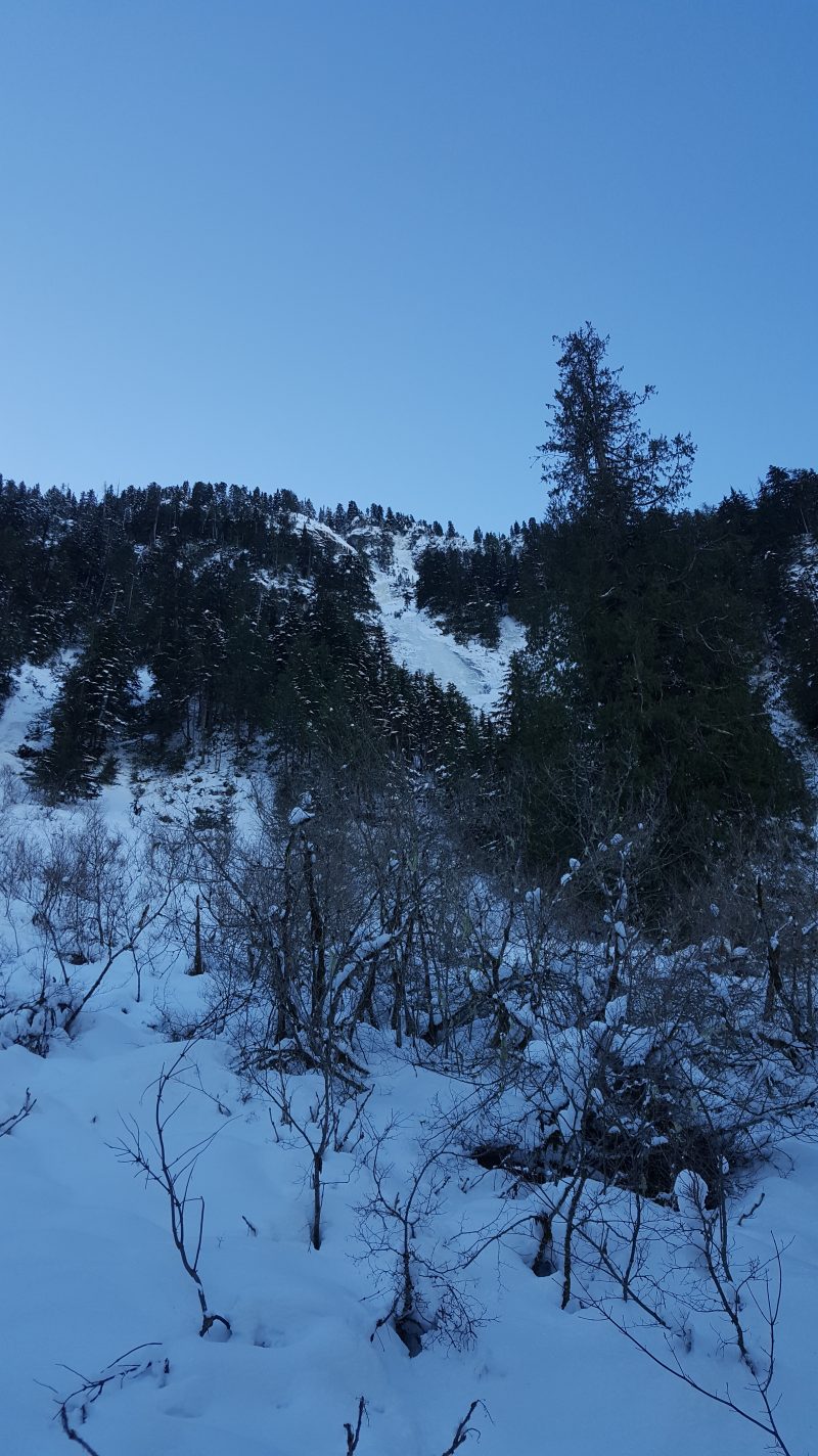
The route from the approach
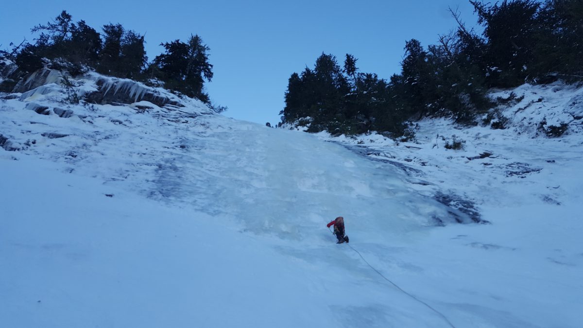
Dave on the 90 meter WI3 second step (pitches 3-4).
Parties interested in making this an alpine adventure can continue for another couple rope lengths and attain the summit. There is an easy gully on the SW side of the peak that could likely be used to skip the copious tree rappels down the route.
The route is named in keeping with the biblical theme of the area.
False Idol
WI3+, 500m
FA: Kurt Hicks, Dave Jordan
6 January, 2017
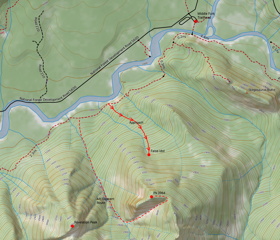
Approach map:
Gear Notes:
10-14 ice screws, 2 ropes to rappel. No rock gear currently needed.
Approach Notes:
Park at the Middle Fork Snoqualmie trailhead. Cross the river and turn right onto the Pratt Connector Trail. Follow this downstream for about 30 minutes until at the bottom of a long set of descending stairs (near a large outcrop with a mini cave in it). Turn left off the trail and ascend steeply up a gully. Continue generally up and slightly left through open woods. Stay to the right of a decent sized flowing creek and gain some large old growth trees. We continued up a short snowy talus field before moving right onto a treed rib and up to the base of the route. If you're bushwhacking, you're blowing the approach. 1.5 hours from the car.
Descent was made via rappels from trees on the climber's right side of the climb. Two ropes are recommended, though we did an endless series of single rope raps since we only brought one cord.
-
1
-

Climate Change Era Routes
in Climber's Board
Posted
The loss of glacial ice feels particularly dramatic this season, doesn't it?! I've been joking for years that climate change will eliminate the need for glacier travel skills in the PNW--I didn't realize it would happen in my lifetime!
A few local ones:
Ice Cliff Glacier/Girth Pillar
everything on the north side of Rainier
Adams Glacier
NW Face of Forbidden
Buckner North Face