
lunger
-
Posts
449 -
Joined
-
Last visited
-
Days Won
12
Content Type
Profiles
Forums
Events
Everything posted by lunger
-
Very entertaining and informative TR, thx. The bit about Cletus and Berge is hilarious--the beginning of an anthology of fictitious mountain name origins? Was up on Cleator a couple years ago, and agree re: the area's diverse beauty, and that incredible trail in a relatively remote place.
-

[TR] Mount Goode - Megalodon Ridge 07/19/2021
lunger replied to Michael Telstad's topic in North Cascades
Nice send fellas. Wondered about this one. Looks like a grand trip. -
Thanks Mark for the news of, and for working on, the fire. I fought forest fires for a couple seasons way back when, and was relieved when we determined we could hike out, but we definitely had our eyes open. Yeah Seth I read your report in prepping for this trip. Seems you guys got plenty of consolation--pretty inspiring place to climb rock. And Rad re: Perfect Pass: for sure, I think that any forecast showing a nonzero chance of precip (say, 10-20%) for that area should be read "periods of certain drizzle or rain". For the record, the only intended double entendre of the acronym was the meaning of the actual word, "whap", which means to be hit hard, or the resultant sound of same. A Northern Pickets trip will often smack you down, or at least leave a mark -- and/or an impression. There's so much still to do there. I encourage repeats of this route. My hasty pictures did not do it justice. Wish I'd taken photos of the void step-across, and more of the good stretches of climbing, but we were pretty intent on making time.
-
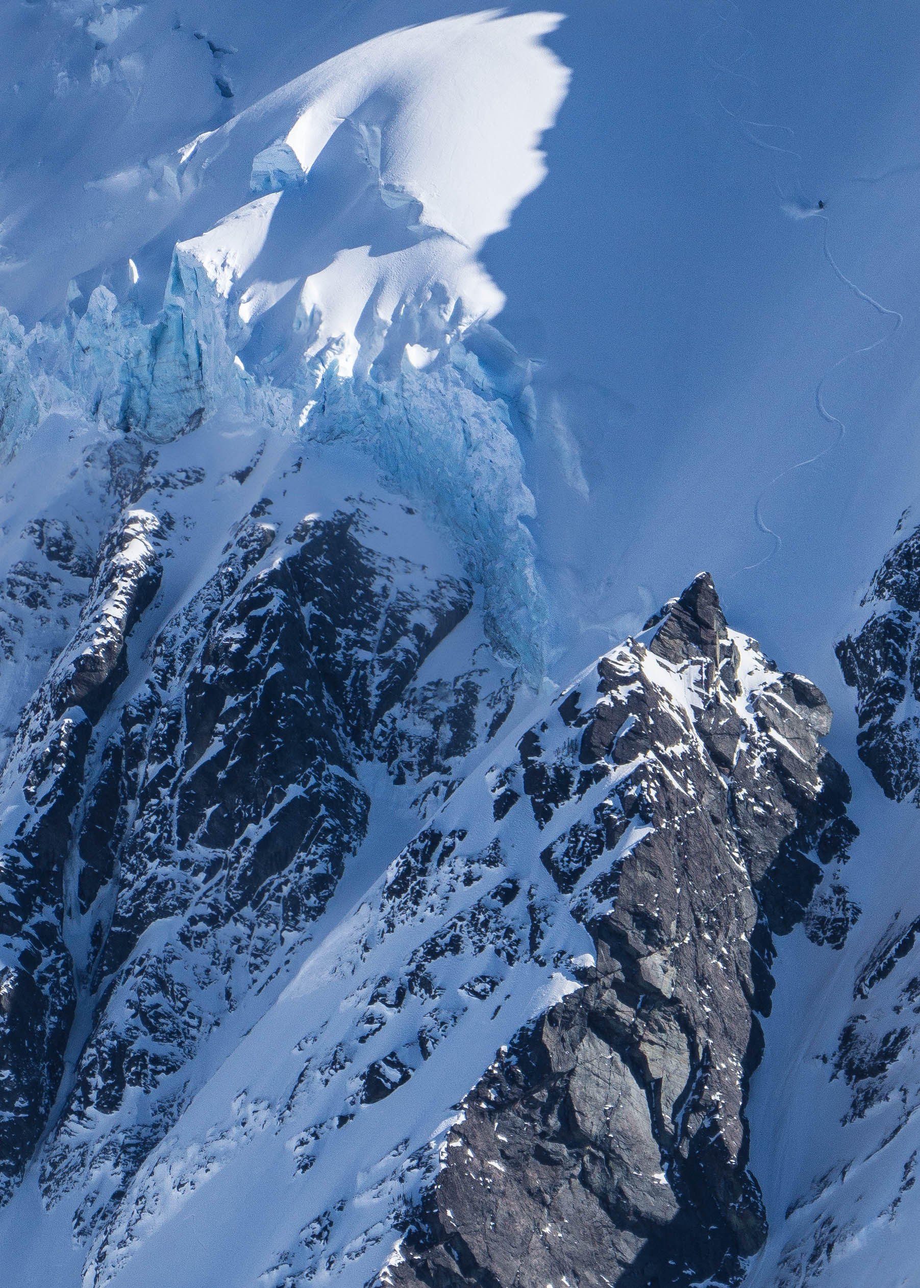
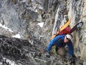
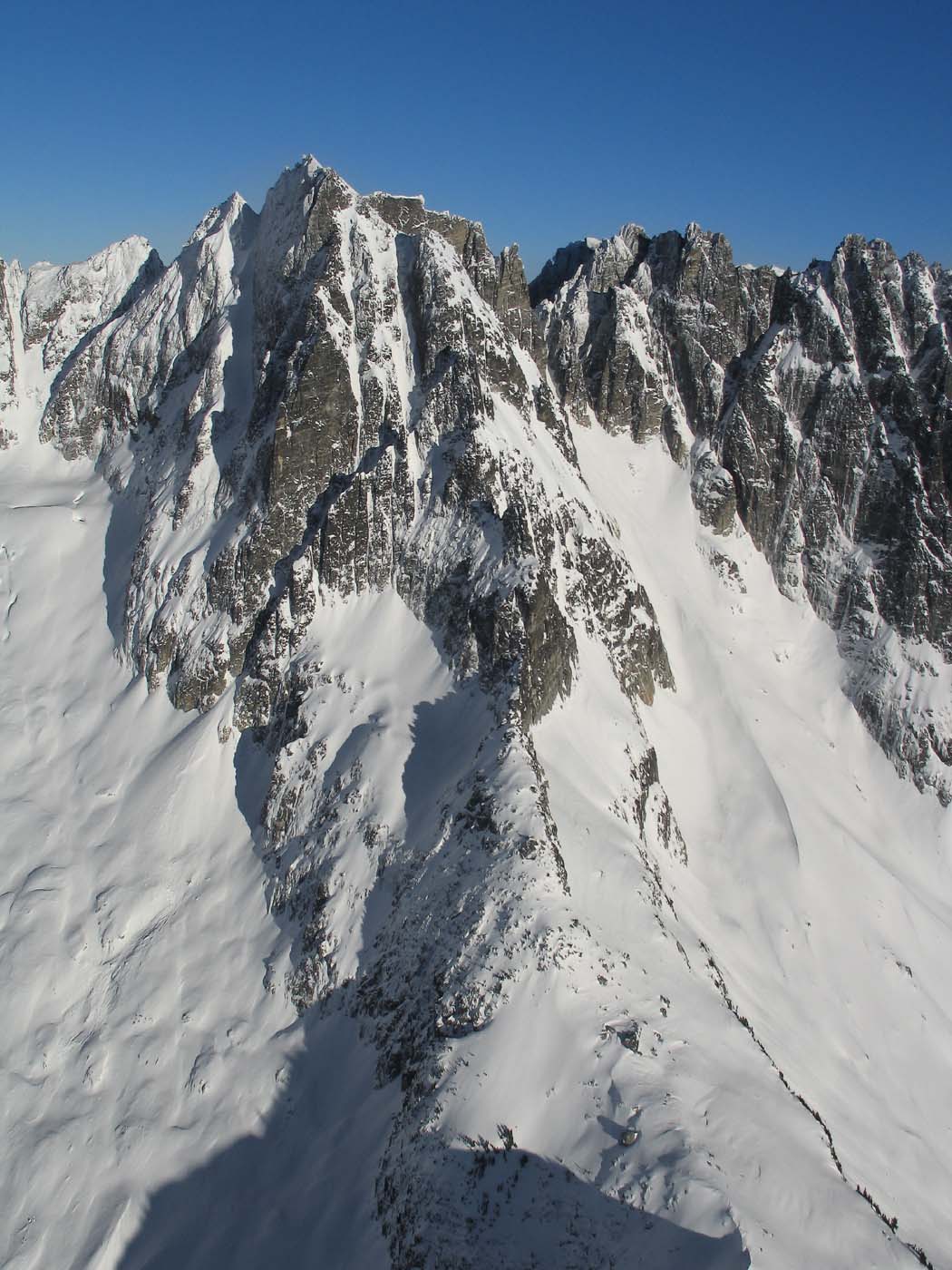
Trip: Phantom Peak, Northern Picket Range - West Ridge IV 5.7+ aka "WHAP" Trip Date: 07/30/2021 Trip Report: "We have a problem" stated the leader of pitch 6. He had encountered an airy and cruxy 4’+ gap in the ridge and simultaneously observed a fresh plume of wildfire smoke erupting in the distant valley that marked the return home. His partner – who could not see him or his immediate problem, but could see the smoke – shouted “What?”, seeking clarification regarding which of many possible problems they had. The leader re-shouted “WE HAVE A PROBLEM”, apparently as if over intervening seconds, a realization intensified that perhaps this was a more general statement, one readily applied to anybody that comes to this place. The first step is acceptance... They quickly concluded that bailing halfway up the ridge would not really impart any advantage to dealing with the new (to be named) Bear Creek Fire, so continued tackling the climb. The pitch 6 problem, a long span across a hundred-plus-foot gap in the ridge, was easily the hardest technical move on themostly 5.7+ route—bound to be a “classic of the range”, as oft proclaimed at each belay. The route takes the right hand skyline to the summit spike well left of center (link to an album w/ annotated pic): The leader used a nut and a sling to create a handhold for tension and a more certain move across the gap. The second on this pitch cleaned the gear, and with the benefit of long legs and a top-rope, made the balance-y stem across the gap and the next move across – probably a V0 or V1 boulder move (5.10ish), depending on leg length. Two pitches later the duo topped out on a tower and rappelled approx. 100' into a notch. Pitches 8 through 10 were on generally solid rock with a pleasurable position. A total of 10 pitches of roped climbing gave way to ~400' of soloing to the summit ridge and traversing a sharp ridge to the summit -- exhilarating. The untimely arrival of the Bear Creek fire compelled us to forego other plans for the area and head homeward. As it turns out, a rainy afternoon through the next morning would have largely scuttled those plans anyway. That same weather pattern allowed us to exit via our entry route, as the fire was a bit north of our return route--thankfully, as the other exits would have involved an even more unsavory amount of distance and logistics. Folks with a certain taste might opine that we picked a plum with this route, as it offers mostly solid rock, modest vegetation, and enjoyable movement. Some high-hanging fruit is rotting on the vine, but this one was perhaps only a little overripe. More pics below. Looking up at part of pitch 1 and a fair bit of the rest: Rolf on pitch 4: Looking down pitch 6 at a chimeric rat-beaver, a fin on the ridge, and Mt Despair in background left: From the summit ridge, a nice view of Crooked Thumb and its subpeak Ghost, w/ the many peaks of Challenger in near background: Invigorating soloing on the summit ridge: From Perfect Pass, the fabulous Baker River drainage, filled with smoke: One in the party -- not gonna say who -- repeatedly urged a fire exit of the northern pickets via the brushy Baker River, convinced that his charm and/or good looks (yeah, after two days of bushwhacking) would score us a ride back to our car. The other was deeply skeptical of this strategy. The return along Easy Ridge under an increasingly smoke-veiled sun; don't worry, if you tire of loose talus and scree, many more paranormal modes of travel await: Here's a link to an album with more pics. Summary: Rolf Larson and Eric Wehrly establish a new route on Phantom via its West Ridge, aka We have a problem IV 5.7+. 10 pitches plus soloing. An obligatory John Scurlock photo of the ridge, extending toward the viewer: Gear Notes: Standard alpine rack. Also made use of tri-cams from fingers (black, pink) to thin hands. Approach Notes: Find the larger truth of the Easy Ridge approach – easy only in the middle – or take other long options. Making liberal use of granny gear with heavy-ish packs, over Wed/Thurs we took roughly 20 hours from Hannegan Pass TH to a moraine camp under Crooked Thumb/Ghost Peak. Generally budget 2 days, +/- a half day.
-
Echo the above, fantastic trip! Great write-up too. I'm (eric here) glad my foggy beta might have helped in some small way. I've only seen one wolverine in the Cascades, must have been a powerful moment. I've also gaped at that wall on the W aspect of NW Mox and wondered -- good on you all for giving it a go. John, by my read anyway, I'm pretty sure Jake and crew climbed the southern lobe, not the northern one--at least it looks like it in their pics. This was the way that Rolf and I descended. I agree that their approach is a novel one, and a nice way to go when approaching from the US. Perhaps Jake can clarify. Solid work gents.
-
best of cc.com [TR] West Fury - Mongo Ridge 07/05/2021
lunger replied to JeffreyW's topic in North Cascades
Respect! Impressive sends by both the FA and second ascent parties, each in their own inimitable style. Thanks for posting up. -
Sweet photos, as always Jason. Love that ski, recall doing it on Halloween one year -- I think your timing was better. How did the Park Headwall look? Any shots that direction?
-
first glance made me think of video peak at rogers pass, but likely not correct
-
Cool seeing activity on Mt Index walls! re: other big-ish walls: Diamond on Bear would be a worthy project, but don't envy you schlepping aid/wall gear back there for an attempt. East face of Tower has some potential, as does the east face of nearby Golden Horn. Buck Mtn Both Hozomeen peaks (the west face of N and north face of S) offer many lines (~2000') that the chicken-donkeys avoided on the only existing (reported) ascents. The more direct line to the summit on the north face of south Hozo would be particularly aesthetic--there's an accordion of steep, corrugated clean-looking corners leading up the upper half. For better rock, siege the direct east face of Mox/Lemolo (>2500'). Some approach pitches required to get to the sheer face. Consider being generous and leave pitons and bolts so the free-climbin' sport-monkeys can go back for the FFAs
-
[TR] Liberty Cap - Ptarmigan Ridge C2C 07/11/2020
lunger replied to bedellympian's topic in Mount Rainier NP
that's a big push. appreciate the pics, looks like engaging climbing conditions. and the entertaining boneless chicken farm pics on the summit slog ring true--single pushes sure get painful up top. -
[TR] Corax Peak - North Face 07/05/2020
lunger replied to tanstaafl's topic in Central/Eastern Washington
Well that looks like fun in an out-of-the-way place. Surprised that Rolf would climb something that actually looks reasonably good--you must've twisted his arm. Is the rock granitic, or gneiss? -
fantastic. yeah, dreamy indeed -- appreciate the pictorial tour.
-
glad you guys enjoyed the report. tanstaafl: yeah, some bad humans left a bunch of junk at one site--got most of it, but lacked capacity for a shattered cooler. Kam: oh, tubby had cheese alright. a lack of cheese threatens his essence. I think you'd enjoy the route and the whole package, it's a beautiful area, and a nice weather option for poor west side wx. Kyle: saw your Berge report; good stuff, that route looks comparable in tech difficulty but of higher rock quality. it probably helps that it gets more 'traffic'. Here's another pic I forgot to post, with Cleator (visible) and Berge's (blocked behind Cleator) grand-daddy Buck looming in background: https://photos.app.goo.gl/axZRhc4xEvjcmumr7
-
Trip: Mt Cleator - Tubby Needs Cheese 5.8+, 9 pitches, 1,000'+ Trip Date: 09/01/2019 Trip Report: It's been a spell since my last report; I offer a tale of an ascetic and a hedonist climbing yet another irrelevant obscurity in their quest for entertainment and raw truth. The weather forecast pointed them east, and Mt Cleator appeared to fit the bill. After a pleasant trail tramp past Buck Mtn and establishing camp, the dialectic duo scouted and debated a number of lines available, and provisionally settled on the cleanest looking one. The line emanates from near the main summit (not the N tower), and is a NW jutting rib that appears to share the granitic character of the pluton on nearby Berge--very little schist encountered. (Other options abound on the N side of this peak up to the N tower, but even these impaired codgers reckoned unappealing the primarily grubby schist on these longer lines toeing down more directly to Buck Cr. They agreed to buy beer for any whippersnapper climbing one of these lines.) For the full Cascades sub-alpinism experience, approach directly from a camp near Buck Creek, where the trail passes close to the creek. Romp up pleasant alp slopes to a band of cliffy terrain, then bunk-jungle up steep alder to pass a waterfall. This approach grants access to the upper basin and the several lines available on the northwestern quadrant of the mountain. For the descent enjoy the scenic trail tour return via Buck Creek Pass. Lots of wildlife encountered--bear, coyotes calling at each other (probably about the bear), deer, etc. The climb's more-technical and mental challenges are concentrated in pitches 2, 3, 8 and 9. (Unfortunately, not many climbing pics taken.) Pitch 2: while the self-styled epicurean showered his pathetic self with sod digging for pro and holds, the wannabe stylite laughed derisively. Pitch 3: the ascetic got his come-uppance, "I wanna go home", but eventually pieced together a lead to the crest of the rib. The middle pitches were more scrambly, mostly mid-fifth and easier. Pitch 8: a sweet, relatively steep and juggy corner. Pitch 9: interspersed short splitters and varied climbing, beautiful and exposed ridge rambling with steeper steps. P1: P3: P6(?), climber low center: On average, the over-indulger and the self-depriver make for a balanced human. In an alternate universe the roles could be switched, and maybe the pair would climb splitter cracks on impeccable stone; but in this one, they reconcile themselves to seeking new lines on inconsistent rock with their mercifully impaired memories. On this climb, a somewhat dirty beginning becomes more enjoyable higher (and with distance). It's difficult to get a well-defined shot of the line. Here's a flavor: Tubby Needs Cheese begins to the left of the shaded red streak on far right, a few hundred ft below that tiny spot of sunshine on the ridge, and continues up to and then on the right skyline. Tubby tops out in the horizontal strip of sunshine, or perhaps just out of view behind the pyramidal feature to the left of it. (The sunlit tower is in the foreground relative to the main summit.) Beckey's CAG vol 2 (2nd ed.) has a good pic of it along with Buck on page 160, swooping down from the main summit clearly marked MT CLEATOR. And from the west, hiking toward Buck Pass: A shot on the way home on Labor Day, TNC in the shade on right toeing down just left of the snow in the basin: More pics (recommend click on 'info' to see descriptions for many): https://photos.app.goo.gl/P2U5SJgB8jU1eQBo8 Gear Notes: Double rack through 3, a 4, some nuts. We didn't use our pins, but some folk might want to. Approach Notes: Park at Trinity. Buck Creek trail, etc. -- see above.
-
[TR] North Howser Tower - All Along the Watchtower 08/06/2019
lunger replied to JeffreyW's topic in British Columbia/Canada
heck yes! thx for the detailed report, good stuff. -
whoa, neato trip, entertaining write-up, and fantastic pics! that Frenzel camp looks five star--both in your pics and from Himmelgeisterhorn a few years ago--must get there one of these days. any berries to feast one along the way? hope the Terror Twins made it out ok. and, hahaha: "You really should go climb both North and South Hozomeen". General's orders like that ensure mutiny. appreciate you taking the time for the report.
-
[TR] Mount Constance - Finger Traverse 05/23/2019
lunger replied to Alisse's topic in Olympic Peninsula
For sure! Constance holds abundant good ski lines. Thanks for the report, and nice work. That mountain's summit is a favorite, exposed and fantastic views all around. -
[TR] Mount Constance - South Chute Solo in a Day 06/23/2018
lunger replied to Asfahl's topic in Olympic Peninsula
nice pics! yes agree that area is gorgeous, lots of cool flora, walls, towers and interesting features, and plenty of local relief. and a favorite spring ski destination, solitude more or less assured in that season. thanks for the vicarious revisit. -
i've wondered the same; haven't consulted the B Bible, but it sure looks vegetated. could still be 'fun' to explore some of those buttresses
-
looks like a cool route. tempted to follow your tracks sometime. and as always, nice pics "The happy(ish) crew, ... before things got really ugly" do tell. did a happy-hippy-skippy ski descent down to the road encounter the cold hard face of shrubby reality? Or is that road uphill both ways? or perhaps avy debris nightmare?
-
first ascent [TR] snoqualmie mountain - possible fa: the turf testament 03/31/2018
lunger replied to rat's topic in Alpine Lakes
nice 'discovery', lads! looks like a solid addition to your empire of dirt. have wistfully looked up at that wondering if/when someone might climb it. how many snargs on the rack? -
[TR] The Pickets - Himmelgeisterhorn - Wild Hair Crack 08/25/2017
lunger replied to just some guy's topic in North Cascades
nice report! whiskey is an essential ingredient to camping in the crescent cr basin environs. 4 hours to the drop-in point near the chopping block? damn, either that trail has been beat in, and/or you guys were moving. with that kind of steam, you shoulda checked out the central buttress on the S face of Terror, a worthwhile climb imo. that Wild Hair Crack climb does rank high on my list of shorter climbs worth the hike...wild place, with neat history. -
[TR] Lovers Leap Road Trip - Corrugation Corner and others 09/18/2016
lunger replied to curtveld's topic in California
looks like a great trip. agree the Leap offers a prime cragging situation. Haystack was my first ever climb, on a lark while visiting my bro in CA. his (relative newbie) buddy had led the crux pitch, that I followed wide-eyed, only to arrive at the belay to hear he wasn't confident in the anchor--my brother would later describe the anchor as 'whimsical'. thanks for the opp'y to revisit that place, good spot for sure. -
Very cool to see a repeat (already)! Nice work. Glad you found the way in from the south works fine. Haha re: your signature, apropos for this particular climb Would like to see some pics if you got'em
-
looks like a fine adventure! congrats.


