


marek
-
Posts
154 -
Joined
-
Last visited
Content Type
Profiles
Forums
Events
Posts posted by marek
-
-
Anyone been there lately?
Road open?
Any info on snow conditions above Colchuck Lk? Picture?
Mahalo for info!
-
Upon rules inspection, replaced image with no photoshop touchups; other version available in gallery.
Also, tried to delete previous post; unsuccessfully; submitting image that is legal.
-
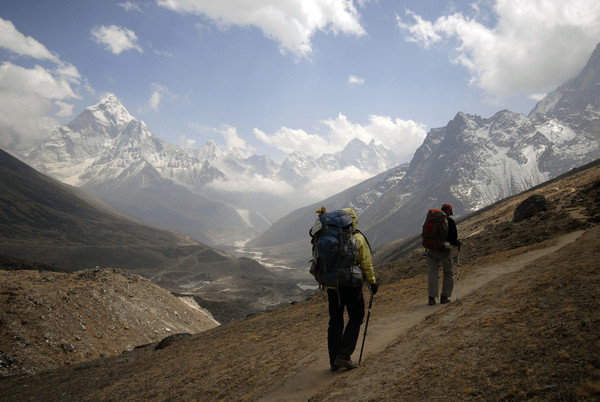
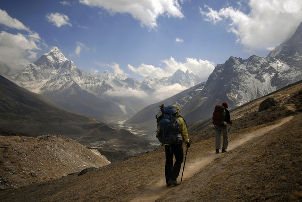
Trekkers in Khumbu Valley, Nepal
-
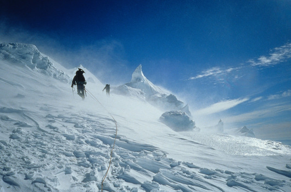
Kautz Glacier, Mt Rainer
-
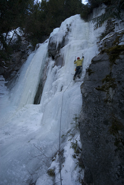
Mike Fields Ice Climbing in Lillolet, Canada
-
Trekkers in Khumbu Valley, Nepal
-
Nice going "Girls" If that was your 1st attempt-then it was fantastic achievement!
Thank you for the story and many pics.
I got it on top after my 4th attempt!LOL! Now I'm laughing
1st, went so fast, we never located the river crossing and continued till "gondola"
2nd, this time located the crossing, but then did not locate the "imperfect impasse"
3rd, got weathered and still could not locate the "imperfect impasse"
4th, summited, but the weather was toying with us to the bitter end; rain at Perfect Pass
Marek
-
Why not just use an AT binding for the downhill portion of the race?
AT Bindings?=Randonee bindings? (free hill on the way up/lock on the way down)
I have old skis with old Fritz'is randonee bindings; is moving them to short skis the only option? Any way to rig my downhill bindings to accept randonee boots?
In Ski to Sea, first one needs to climb up about 2K feet, and then ski down in the same equipment; no backpacks, must ski down in boots used on the way up.
Last year I used short kids skis to save weight, but climbing up in ski boots sucked! I think I can save 5min+ using more flexible boots (like my yellow Koflahs)
Any suggestions?
Marek
-
I'm not a Randonee guy, but will need this set up for Ski to Sea
Do the boots clip into downhill bindings?
Marek
-
I know this was few days ago, but how was the road access? Can you drive? Bike or skis?
-
Dude, nice find and good work!
How was the road? Bike or ski's
-
I coach track and cross country for 3 schools in South Seattle, and it is just fantastic to see how some of them develop into star athlets; already can't keep up with my 13 year old son's interval trng.
-
A friend of mine has this at Kendal Mountain Festival in UK
I loved it!
-
A friend of mine has this at Kendal Mountain Festival in UK
I loved it!
-
pm sent.
kinnikinnick did U find out about the moat conditions?
-
New photos added, and here is a link to TR with images on NWHikers
http://www.nwhikers.net/forums/viewtopic.php?p=518283#518283
-
Here is our report, link to picassa images is below the text
Day one
After reading over multiple reports and hints from previous Ptarmigan Traverse, we set out for project at 5am on Jun 29th. Having good weather forecast we had one less thing to worry about; just move forward! We left Seattle at 5am and parked 2 cars at Suiattle road blockage; some 9 miles away from trailhead, then on, we drove to Cascade Pass-all the way to the parking lot!
After countless repackaging of our stuff and weeding out “presumed unnecessary” items, we went uphill 2K feet up the switchbacks, and after short rest, we then moved up a steep traverse to Cache Glacier (that was a steep and exposed slope with heavy packs) Cache Glacier looked very good with no crevasses at all; no moat either! The way to still frozen Kool Aid Lakes was over steep but easy snow slopes, so we pressed on. Having still few hours of light and energy, we continued to Arts Knoll above Red Ledges and stunning views of Spider and Formidable. Red Ledges were very easy to navigate, and snow free bivy sites some 50 yards away offered far better place to stay than Kool Aid Lakes. Running water was 10 minutes away. I think, this is a far better place to camp than Kool Aid Lakes.
Day 2
We left the camp 6sh and made it to the base of Middle Cascade Glacier in 2hrs or so, over easy snow slopes and some scree/trail? The glacier was in perfect condition, and there was no moat at all. We used the lower/left/eastern col to descend and traversed down and right (west) to a nice bivy spot below Point 7285 (pass/access to Formidable just to the right of it) our next objective before dropping to Yang Yang Lakes, was Mt Formidable. Having had several trip reports in our hand (Klenke, Michael Stanton, Summit post) we thought we were dialed in, but with snow dripping in onto rocks and two of us with plastic boots, the going was slow; we even belayed one spot over a ramp. With the snow obscuring parts of the way up, we lost and found the right way several times, finally rolling onto the summit at 4pm? Once on the top, our first thought was “how in the world we going to get of this choss pile”? And since we had a nice rope, we just rapped the thing all way to the snow (into the gully/option B in Klenke report) and down climbed/traversed the rest of the way. We got to our packs at the last light and then continued to the lakes, where after much needed replenishments, we finally hit the sack at 1am!
Day 3
After a long day 2, we took this one a bit more leisurely, baked some in the sun, dried things up, replenished fluids and refocused. I think we left before 10am? And instead of back tracking and going over a bluff, we just went straight over a Goat Pass? (We followed a tip from a couple in front of us) Sure enough, it worked like a charm and we made it to Le Conte Pass in no time. The pass was the beginning of a long traverse on the Eastern side of the crest and access to Le Conte Glacier. Easy going here, few butt slides. The glacier looked very good, with few holes at some distance away and no moat/access issues. At the top of Le Conte Glacier, we decided to climb Old Guard (better rock!) This time it went without hick-ups and we relaxed at the top for a while (no summit register?) Thereafter, the traverse on the Western side of the crest went easy below the slopes of Sentinel Peak and onto the top of South Cascade Glacier and Lizard Pass shortly thereafter. Did we see buildings on the opposite ridge overlooking South Cascade Glacier? Geological station? There were probes all way around; anyone knows anything about it? Also, the whole glacier here was infested with small 1-2 inch bugs. Any info? We found this to be very interesting. Now, the view from Lizard Pass was just a stunner, and we just stood there looking. The White Rock Lakes are right there below, and the way down was a steep snow and scree (even a cornice) but with few minutes of unnerving stuff, we were at the camp. Yes, as advertized, it was a very picturesque place, and we soaked the views during the dinner.
Day 4
At this point of the trip, my ankle was giving me more and more pain; especially during traverses and down climbing, and as it was decided on a previous day, I would carry only to Dome Peak, and skip Sinister. The traverse to Dana Glacier was straight forward, but over tedious slopes of mixed talus fields, scree, snow and blueberry patches. Reading trip reports, Kuba had found a better access to Dome Glacier, instead of going for Spire Col; we went one valley over to the left/east, and very quickly gained Dome Glacier. With close to no wind at all and heavy packs, we were baking tremendously and our tempo slowed down significantly. After we ditched our packs at the Dome Col, we went for the summit over moderate snow slopes to the summit ridge. After being here before (8 years), I was surprised at the sight of a snow/cornice on the Eastern side of the summit ridge; I knew there was a ledge below, but this much snow on such a small ledge, hmm? Anyway, we continued over the ridge until the final summit block (summit 3 feet higher) at which point I could not scrape anymore rock with my plastic boots. That was a stunner to me, because I did not recall having any problems on my previous trip up here. Lastly, Kuba gave it a look to no result, and we called it a day. Then, when we all met at the packs, it was decided that we would scratch Sinister, and we walked down to Cub Lake over Itswoot Pass. Unfortunately, there was no snow free area, and a tent was pitched on snow for the first time during our trip. We fell asleep with the company of some bats fishing in the Cub Lake.
Day 5
With at least 22 miles ahead of us, we got up early and hit the trail at 7:30am, warming up on the way up to the pass above the lake. Already on the other side, we followed some faint tracks in snow, and dropped down and left over avalanche destroyed forest of Bachelor Creek. From what I remembered on my previous trip here, we went down and left across fallen trees into deep forest, and continued to traverse for few more minutes in the tall forest. As it turned out, we could have gone straight down on the edge of the deep forest, so once we realized that, we quickly dropped down and found the trail at the bottom with no issues. We then followed the trail, losing it and finding several times (still some snow) until we got out of the forest and onto a field of slide alder. At first we dropped down towards the creek (avi debris) and realized our mistake. We then dropped our packs for rest, and I went looking uphill for now difficult to find trail. Sure enough, score! So, we followed this “secret passage” to a ford log and out of the mess on the opposite side. The trail down Bachelor Creek dragged on for ever with many more fallen trees obscuring the trail than I’ve seen here before. Upon arrival at the Downey Trail/Six Mile Camp, we took a nice rest drying things out and dipping into the creek, before we moved on to one push move over 6 mile trail to Suiatte River. When we finally made it, first signs of blisters appeared on my feet and out of Aleve pills, my ankle started to really giving me pains. We still had 8.5-9 miles left to the car, and without much delay, we ripped the first 3 miles in 1 hr, to more alarming pains from ankle and feet. I realized that any time I stopped, the start was even more painful, so I resolved to not stopping at all, and continued at ever slower pace. The energy was there, but the pain was unbearable. Going so slow, mosquitoes and flies had a feeding frenzy, biting just about everywhere-constantly! The boys had offered bug repellant to me, but I had no stomach to stop, and thus continued to be eaten alive. At last after 11hrs push we made it to the cars, ending our 5 days in the mountains.
Jacek and Kuba thank you for the company, Polish food, bunch of jokes and humor, and Jacek, congratulations on your achievement!
Quite possibly, this was first Polish Team Ptarmigan Traverse
Marek
-
Pics are here:
http://picasaweb.google.com/brsheh/2009052526MtRainier?authkey=Gv1sRgCP6bs-vAktW6NQ#
http://picasaweb.google.com/fieldsmr/Climbs20095Rainier?authkey=Gv1sRgCNeQr6eD0MajuAE&feat=email#
Mike (yesman on CC) Bob and me, we left Seattle at 8am and after “making friends” with MRNP rangers (particularly with one) we started sorting our gear. A quick look at the gear, then at the mountain, then again at the gear, proved to be decisive, we went down from 60m rope to short 30m one, then from tent to bivy, from 2 stoves to one, and so on until we were able to squeeze gear into our day packs. We weft Paradise at noon and geared with flotation devices known as snowshoes, for that reason we were not up to our balls in snow and we made quick progress. For now the route goes smack in the middle of Nisqually Glacier, but that will change as the glacier starts to break up; upper section has a split, you may go up and left under falling rocks, or to the right. The two releases of rocks the size of small refrigerators reassured us that taking the right side was better. Upon reaching the crest of the bulge, I felt the stump all way around me; I knew this slope could go at any moment, so I gingerly climbed up to the edge of crevasse and belayed the rest of the team. The upper section of Nisqually Glacier was easy, but super crevassed; it’s not going to last for a long time. Some 5hrs after we started, we settled in the picturesque camp on the ridge (9,300ft) overlooking Fuhrer Finger and Kautz Glacier. One interesting thing was that we were able to melt almost 15 quarts of H2O using only ONE bottle of fuel!!
Next day, after some needed rest, we got up at midnight and started to cross Wilson Glacier at 1:30am, reaching the base of FF at 2am. The way was super easy and yesterdays glop was frozen solid. We then figured the conditions were so very good, and since we most likely would not put pro, we decided to solo the couloir; the whole 2,000 feet of it! While we were climbing, there was no rock fall or signs of it, just intermittent steps at an angle of 40-45%. We topped out the gutter at 4:15am after what seemed to be a never ending snow slope.
Just as we were traversing onto Nisqually Glacier, the weather started to turn on us, with ever increasing winds and total whiteout, at which point we decided to wait it out to see how the weather turned, and so we could see more than the current 50 feet. Team work kicked in, with everyone adding new ideas; first I found a “nice” crevasse, then Mike came up with his sleeping bag so we could cover our legs, then some minutes later Bob broke the bank and we all ended up in our own sleeping bags boots to head! It was all nice and we even got some sleep; if I could just rip off a puffy off of one of my partners?! The “time out” was a good thing, for we got some rest, warmed up, and the fog was gone. As it turned out, the entrance to the glacier was very easy and in minutes we were trotting in the middle of it. As we gained altitude, encountering few crevasses and bridges, the weather got worst by the minutes; above 13,500ft, there were steady 40 miles+ winds and gusting to more than 60 miles, spindrifts a constant, with very low visibility. The going was slow, but we were making progress, edging our way up, now post holing constantly. At the time, we didn’t know where we were, but we knew the crater was our savior; not wanting to climb down the same way, we needed to find the start of DC route. Nearing the top, our faces were still blasted by the wind and snow, and our feet got cold, now at the end of the rope and without a down jacket, I was feeling the cold the most.
We topped out the crater rim some 100 yards from Columbia Crest (GPS) at 11am, and due to our poor state, we decided to find shelter. It went all “classic Rainier” instead cold bivy behind rocks; we found a passage into the crater, some 30-40 feet deep. There, we found quite livable chamber with warm air sipping through the rocks, and significant dump air. Inside, few minutes of digging wet dirt and rocks, had got us semi-useful benches for sleeping for now a second “time out” The 2 hrs of rest and warmth had given us time to focus and re-evaluate the situation, and we decided to look for a start of descent route, and if it didn’t work out, we were to return to the cave. At the time, I was quite confident I could find the way down, but Mike and Bob were uneasy about it; no guarantees though, despite my previous 16 summits. As it turned out, it took us just few minutes to find the well worn track and some wands below; we were going home!!!
The rest was a piece of cake navigating crevasses; DC looks good, and it still goes Ingraham Direct, but it will not last long, as there are few poor bridges and connections. There is a huge ice wall right above the top of DC, and it’s active! In all, a looong day!
-
Looking for partner or partners for Argonaut Pk-link below.
http://www.sverdina.com/argonaut/argonaut1.htm
Weather looks good and the road is open!!
(walked the darn road too many times lately!)
Can only do Friday!
Leave Seattle early 2:30-3am?
More about me: www.frozenimage.net
Marek
PM me or marek@frozenimage.net
-
Crossing that bergshrund might be a bit of a challenge. I can imagine things getting pretty chopped up on the way there too.
Ehh!, It should not be that bad. Shrund? That might be the only problem, otherwise it should go into late season.
We did it July'ish? and I do not recall jumping over anything; that's if you're arriving at Perfect Pass end.
Still worry? Do the Shwack Eli-Wily, and you're on the shoulder.
-
Partner Found!
THX
-
Still Waiting! Weather is Good!
-
Loking for buddy for the following:
Ice Cliff Glacier Sun-Mon or Mon-Tue
Argonaut Pk Sun-Mon or Mon-Tue, one day?
FF or Gib Shut on Tue-Wed
Be fit and do not be a flake!
Marek
bit more about me here: www.frozenimage.net
pm me or marek@frozenimage.net
edited due to weather on the west side
-
Partner needed for South Twin; Tuesday only!
I've already done North Twin, but if we have time, we can do that one too. Bit more about me here: www.frozenimage.net
Keys Pk. is in the play too!
Mt Baker N side access - NF 39 conditions
in North Cascades
Posted
Thank you Jason!