

AOC
-
Posts
53 -
Joined
-
Last visited
-
Days Won
1
Content Type
Profiles
Forums
Events
Everything posted by AOC
-
Trip: Mount Rainier - Ptarmigan Ridge (attempt) Date: 6/12/2008 Trip Report: On June 12 – 14, John (NY), Henry (Chicago) and I (Albany, NY) set out to climb Ptarmigan Ridge and descend the D.C. route. We knew beforehand that snow levels on the lower mountain would present a huge problem. But when the forecast finally called for good weather we decided to take our chances. After spotting a car at Paradise and driving the 100+ miles to Mowich Lake Rd., we headed out from just below Paul Peak trailhead. Travel on snowshoes (shit! – extra 12 pounds of total gear) was reasonable to Mowich Lake, which we found buried under 10 feet of snow. But after passing the lake, travel was stalled by deep, wet snow, especially the traverse below Hessong Rock on the way to Spray Park. We crawled along under our heavy packs at about one-half mile per hour. We all took tumbles into deep tree wells along this section of the approach. We camped just below Spray Park at 5200 feet. The next morning better snow conditions in the alpine zone made for reasonable progress but we stalled breaking trail up the Russell Glacier and later on lower Ptarmigan Ridge. After 11 hours of effort on approach day-2, we bivyed on the ridge at 10,200 ft. The route looked to be in perfect condition. But we were not. Too spent to commit to a one-day push up and over to Camp Muir, we reluctantly descended the next day. After returning to Paradise to pick up the spot car, John and I did a consolation climb of the D.C. route to 13K before being stopped by high winds. On Ptarmigan Ridge we saw only our own footprints and a bear. It is a beautiful route. I plan to return (without the snowshoes).
-
We're flying in from New York and Chicago to try Ptarmigan Ridge in mid-June if the weather forecast cooperates. We did the approach from White River on a climb of Liberty Ridge a few years ago, and now want to approach from Spray Park to see more of the mountain. But Mowich Lake Rd. won't be be "open" by then. We're willing to hike 5 or 6 miles of road. Does the "closed" designation mean the road will be gated? Or can you drive and park as far as snow conditions permit? Thanks - Al
-
[TR] South Arapahoe, Colorado - south side 10/7/2007
AOC replied to snugtop's topic in The rest of the US and International.
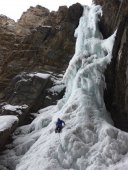
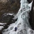
Climbed Spearhead north ridge 2 weeks ago. Enjoyable, easy climb. Would have been "super fun" but we got hammered with lightning and blinding snow on the last pitch. A couple of photos: -
The OP knobs don't fit BD Turbo screws (the slot is too small for the BD hanger). You can open the slot a bit with a file but the locknut won't fully engage. In any event, it's not worth the trouble because the knobs will inevitably break off. (They're great as replacement knobs for OP's though). I don't know how they might fit other screws.
-
I've had luck with the East Coast partners section on rockclimbing.com You might also try posting on climbnyc.com Gunks.com has a partner database but it is fee-based. Many people have luck finding partners in the West Trapps parking lot. Have fun - there are scores of classic climbs in the 5.8 - 5.9 range at the Gunks. PM me if you'd like some suggestions.
-
Two tools is overkill IMO. The route is just not that steep. Take a moutaineering axe and one tool. The Black Pyramid barely approaches WI 2. While the bergshrund crossing above can involve steeper terrain, it's short. If necessary, the leader can climb with a borrowed tool and then lower both tools to the second.
-
I've spoken to Jerry Cooke a few times about ice climbing in the Adirondacks, but never met him. From his Liberty Ridge trip report, it seems he met Kelly James and Brian Hall on the route this past June. So this is likely the first time the three have climbed together. In addition to Liberty Ridge, he has apparently climbed the Emmons route, Baker (Easton), Shuksan (Sulphide), Athabasca, and done a guided trip with Barry Blanchard on Assiniboine. Hope and prayers for everyone's safe return.
-
So the "Gray Lady" is reporting Hot Flashes? - Congratulations on the wild climb and great article.
-
quote] "The credit belongs to the man who is actually in the arena, whose face is marred by dust and sweat and blood; who strives valiantly . . . who does actually strive to do the deeds; who knows great enthusiasms, the great devotions; who spends himself in a worthy cause; who at the best knows in the end the triumph of high achievement . . ." High Achievement - American style
-
Plenty of snow is right - almost continuous from lunch counter to summit on 8/15:
-
Climb: Whatcom, Challenger, Luna Cirque, Luna Peak- Date of Climb: 8/4/2006 Trip Report: This trip report is far too long. But I'm a long-time lurker who suddenly has a lot to say. I’m from upstate New York, and my partner, Henry, is from Chicago. A third partner, Dan, is from New York by way of West Virginia. He recently moved to Burlington, Washington, in part to climb in the North Cascades full-time. We’ve made annual trips to the Cascades in recent years to climb marquee routes on the volcanoes, Mt. Stuart, and in the Cascade Pass and Washington Pass areas. This time, we wanted in deeper. It was time to head into the Northern Pickets. The original six-day plan was to climb Mt. Challenger via the Little Beaver trail and Whatcom Peak, descend into Luna Cirque, climb Fury North Buttress, and finally Luna Peak before hiking out to Ross Lake trailhead. The itinerary was inspired by Donn V’s excellent 2005 trip report, “Old Guys on Vacation.” Donn V. and his partner completed the trip in a relatively leisurely 8 days. I too am an old guy, born during the Eisenhower administration. I could have benefited from a few cushion days built into the schedule. But Henry is considerably younger, has a toddler at home, and at the last minute could only get away for 5 days. As it turned out, we had to skip Fury and it still took us 5 ½ days to complete the circuit. To save nearly $200 in airport-zone car rental surcharges, I grabbed a cab to downtown Seattle, rented a vehicle, made the obligatory stop at the REI Reichstag, and then doubled back to Sea-Tac to pick up Henry, whose flight was 5 hours late. We inched our way north on I-5 to Dan and his wife Michelle’s place in Burlington. Thence began the ritual shucking of gear and supplies until the loads weighed about 35 pounds. Mistake #1. Because we didn’t know when we’d arrive at Ross Lake, we waited until the next morning to call the resort for a water taxi ride to Little Beaver trailhead. The short-range boat was engaged ferrying guests (and their crates and crates of beer) from the dock to the resort. The long-range boat was rumored to be at the far end of the lake. After a considerable wait, the long distance boat materialized, and for the bargain price of $95 (recently raised from $70) we enjoyed the scenic ride to Little Beaver trailhead, with views of the Colonial Glacier peaks, Jack and Hozomeen mountains. We paid $30 more for the return trip via Big Beaver, and confidently told the driver we’d call from a cell phone up high to make arrangements for a pick up (mistake #2). We settled into a comfortable all-day pace on the nearly level trail, passing through groves of giant cedars, with occasional views of the river and the surrounding lower peaks, before plopping down 14 miles later on a sandy riverbank just shy of Twin Oaks campground. The next morning the views opened up as we gained elevation on the way to Whatcom Pass. The huge waterfalls streaming from the north side of Wiley Ridge were especially impressive. Dan, whose lone regret about moving from New York is the relative inaccessibility of ice climbing in the Pacific Northwest, displayed his extreme desperation by openly contemplating a return trip to these glacier-fed falls in winter, armed with tools. Half-way up the trail to Whatcom Pass, Dan and Michelle confessed they weren’t feeling up to the mountain route, and would return to Big Beaver via the trail over Beaver Pass. This was probably a wise choice because Michelle started climbing less than a year ago. Although none of the peaks is technically difficult, the long mountain route was guaranteed to inflict the kind of pain normally unassociated with vacationing newlyweds. (Plus, I think Henry and I were beginning to smell by this time.) We said our goodbyes, and (mistake # 3) failed to ask them to cache a little food for us on the way out. It was hot and, as advertised, Whatcom was loose and exposed, especially the last thousand feet, which was mostly rock with two short snow arête sections. We stopped frequently to tank up – abandoning water treatment now that we were above the fear-inducing “Little Beaver River.” Whatcom has excellent views for an “approach” peak – Mts. Redoubt, Spickard, Shuksan, Baker, Challenger, Luna. And off in the distance – the most alluring one of all . . . Mt. Slesse. After climbing down the ridge a short way, we made quick tracks down snow to Perfect Pass, where we camped for the night. The next day dawned clear and was, by far, the easiest. We roped-up, traversed the Challenger Glacier, and dropped our packs on some rocks about 2000 vertical feet below the summit. Here we were delayed by lack of water, and had to melt snow – the only time during the trip. The climb to the Challenger summit area is a breeze with a wide crossing of the bergshrund on the right, followed by a short moderately steep snow section. I lugged up rock shoes because Nelson and Potterfield rate the short rock section at 5.7+, and I am only a 5.8 Gunks leader. Courage, fellow lurkers, for 5.7+ it surely is not. More like one move of 5.4. We spent a long time on the summit, admiring the north buttress of Fury, knowing (but not yet openly acknowledging) that we couldn’t get up it in the allotted time. I tried the cell phone (a Tracphone) without success; we rapped 40 feet, and were back at our packs in 45 minutes. We traveled down Challenger Arm and rehydrated an early dinner from our dwindling food supply. Mistake # 4: We thought we could get away with splitting freeze-dried meals and packed only five. The packages say “makes 2 servings” but that’s true only if you are 4 years-old, or have undergone gastrointestinal bypass surgery. The calorie content is far too low for this level of activity. Unsatisfied by half portions of Kung Pao chicken, we began to pick our way down Luna Cirque, consciously trying to stay to skier’s right. The going was surprisingly clear on snow, scree, and talus. For a while it actually seemed like we were on course. But we soon found ourselves in the scrub on steepening terrain. We tried to push right through the trees but found the way blocked by steep drainages. Archeological finds (e.g., vintage 70’s orange knit cap) confirmed we were not the first suckers to be lured down the major waterfall on the north rim of Luna Cirque. We should have pushed very far right when we were still high on the rim (mistake # 5). We broke out the skinny rope, glad to have the full 60 meters. (I had considered chopping my old rope in half for the trip.) Three raps, two from trees another from nuts, brought us to a broad, gently sloping ledge where we decided to bivy, rather than screw around with tree raps in the dark. We were about 600 feet above the floor of the cirque, directly across from the north buttress of Fury. I couldn’t imagine a better place to spend the night. Although tired, I stayed up late to watch meteors shower over the cirque, and listen to debris crash and rumble down the icefalls. In the morning (another beautiful day), two down-leads brought us to hikeable terrain. One of them resulted in the only injury of the trip. I thought Henry was down-leading, while he thought I was lowering him down a short section around a corner. When his full weight unexpectedly came on the rope and he swung, whack!, three knuckles on my brake hand smashed against the rock. There was a fair amount of lost skin and bleeding, but otherwise no serious damage. The accident could have been avoided by better communication, or if I had just thought to redirect the belay through the anchor (# 6). It was now the moment of reckoning. It was 8 a.m. on day 4. Even if we managed to summit Fury today, there was no way we could possibly descend the standard route, bushwhack and hike 15 miles by 5 p.m. the next day, when the water taxi stops running. We reluctantly moved on, setting sights on Luna Col as a respectable goal for the day. Next to the Cirque of the Towers in the Wind River Range, Luna Cirque is the wildest and most awe-inspiring place I’ve ever been. Once the decision to skip Fury had been made, we relaxed and just enjoyed being in this stunning amphitheater. The climb to Luna Lake was made easier by a snow ramp on the lower reaches of Fury Glacier, allowing us to bypass horrible scree slopes. Above the ice floe-laden lake, we found the way clear for a while but soon lost track of the route. I thought the path would be well-trodden, but now realize very few people venture into the cirque. We eventually gained the long heather and talus slopes leading to Luna Col by climbing a short, wet 4th class section on the right several hundred feet above the lake. At this point Henry announced that, not counting our one remaining freeze-dried meal, he was down to one Gu packet and a liter of Cytomax. I was a little better off for food. But we’d still have to endure the next day and a half on about 500 calories each (# 7). Luckily, hunger pangs are easier to endure when you are camped at a place like Luna Col, which, along with the summit we casually climbed the following morning, has the best view of any place I’ve been in the Cascades (better even than Sahale). Unluckily, my cell phone didn’t work on Luna Peak either, and without a water taxi pick-up, our reverie was dampened by the thought of 7 additional miles, or a total of 22, back to the car. Just in case, we stowed away our 2 remaining Gu packets to propel our bodies those last 7 miles. Finding the correct ridge crossing at 6100 feet leading to Access Creek involved about an hour of trial-and-error. We descended too low and should have stayed higher on the southeast flank of Luna (# 8). At one point, the heather slopes got so ridiculously steep we actually put crampons on. (No one was there to laugh at us, so what the hell?). One hour of scree-skiing and talus-hopping brought us down to the creek, where we rested and steeled ourselves for the bushwhack ahead. I’ve always wondered about the fearsome reputation of Cascades bushwhacks. I’ve done a lot of bushwhacking on Adirondack trail-less peaks in New York – where the firs sometimes press so close your feet can leave the ground for 50 yards at a time. Devil’s club? Slide alder? How bad could it really be? Pretty bad it turns out. We thrashed through heavy slide alder close to the creek, mainly on the north side, before the terrain permitted us to move upslope, where the going was always easier. At times, we were funneled back towards the creek, where we invariably got bogged down miserably. Downed tree trunks often provided the only means of forward progress. It took us over 4 hours to complete this 3 ½ mile section. When we finally reached the Big Beaver River, we were in no mood for tedious scouting of the bank for a safe log crossing. Henry charged into swift current before thinking better of the idea and retreating. Downstream, we found a calmer spot, where we waded across in boots. One hundred yards upslope, the trail!! Time to switch to automatic pilot for the 7 miles to 39 Mile Creek campground. Now that I no longer had to think, I became conscious of the pain in my legs and feet. I could tell Henry was suffering too, as he silently marched behind me in the dark. At the campground sign, we found a message from Dan and Michelle, who had been through here a day earlier. It was late and, encroaching on someone else’s site, we threw down the tent, crawled in and went to sleep. As luck would have it, the site we invaded was occupied by a boy scout troop from Cle Elum on a long-distance hiking/canoeing trip around the lake. The leader, a friendly outdoorsman active in the Moutaineers, was carrying a satellite phone, which he graciously let us use later that morning at Big Beaver trailhead dock to call for the boat. Reprieved, we rode the fast boat in a state of pure alpine satisfaction, nearer and nearer to Concrete . . . and Philly cheese-steak sandwiches. Gear Notes: 60 m. 8.2 rope Small rack nuts, med. cams, slings B.D. Firslight tent
-
Challenger, Luna, Fury- Les Voies Normales 7/20-27/2006
AOC replied to ckouba's topic in North Cascades
Thanks guys. Those photos -
Challenger, Luna, Fury- Les Voies Normales 7/20-27/2006
AOC replied to ckouba's topic in North Cascades
Thanks for the great photos! We're planning to climb Fury North Buttress later this week. Did you happen to get a look at the approach on the right side of the buttress? -
From today's Anchorage Daily News - "Hope fades" http://www.adn.com/outdoors/story/7828926p-7735328c.html
-
Asked a similar question about Stuart few years ago. Here's the sage advice from the locals: http://www.cascadeclimbers.com/threadz/s...true#Post174486
-
Considering a pilgrimage to the N.E. Butt. this summer. Does any good commercial topo map of the N. Cascades cover Slesse? Looking for more detail than the 1:50,000 Canadian scale. Any good on-line sources? Thanks for any info.
-
I had some free time in the Cascades but no partners a few summers ago. Soloed Frostbite Ridge (Glacier Peak) - a fun route with WI2 and some steep snow near the summit. The approach glaciers were gentle with only a few narrow cracks (mid-Aug). Parts of the long approach were washed out a few years ago, however, and I don't know whether the trail has been re-established.
-
[TR] Mt. Washington- Damnation Gulley 12/10/2005
AOC replied to JayB's topic in The rest of the US and International.
Nice TR and photos, Jay. Good climbing with you. Ken4ord is right about Cannon and the Black Dike. Maybe later this season? -
Check out this website - lots of information about backcountry set-ups: http://home.comcast.net/~pinnah/DirtbagPinner/dirtbag.html
-
Good points. The main anchor was backed up with gear, but the back-up would have been useless if the block fell. Either I would have been crushed or the backup would surely have failed. I bounced tested it while tied into the back-up gear only.
-
Last week while rapping off Mt. Sill in the Sierras I had a close call when a refrigerator-sized block shifted in mid-rappel. My alert partner shouted a warning and I was able to quickly get my weight off the rope and escape the system. I had bounce-tested the new anchor and called it good. I'm thinking now I may not have tested it at the proper angle given the orientation of the descent gully. In light of my lucky break, and the heartbreaking events on Sharkfin Tower, I'm wondering if there is any technique, other than (proper) bounce-testing, to evaluate blocks that appear solid as the Parthenon?
-
www.gunks.com - The "must do" list includes classics for all of the grades. At this time of year, you might even be able to get on some of them. Have fun. - AOC
-
Does anyone have information about access to Stuart this summer? We are planning a 2 day mid-week climb of the north ridge in early August. I know bridge construction will affect access to the Stuart Lake trailhead, but I was told by the F.S. that no advance permits are being issued for Stuart, even for our intended route from the south (Ingall's Pass trail). If possible, we'd like to avoid a lottery as we are flying in from New York and Chicago. Thanks for any info.
-
The mountaineering opportunities can't hold a candle to the Cascades, but there is good hiking, rock and ice climbing. Check out these notheast sites: www.gunks.com; www.neice.com; www.viewsfromthetop.com
-
I hauled a rope up there because I heard the downclimbing might be awkward. But I never used it. There is only one low 5th class move directly beneath the (spectacular) summit block.