


ckouba
-
Posts
173 -
Joined
-
Last visited
Content Type
Profiles
Forums
Events
Everything posted by ckouba
-
Any pics? CK
-
More in the gallery: http://www.cascadeclimbers.com/plab/showphoto.php?photo=987 http://www.cascadeclimbers.com/plab/showphoto.php?photo=986&papass=&sort=1&size=medium&thecat= http://www.cascadeclimbers.com/plab/showphoto.php?photo=985&size=big&papass=&sort=1&thecat= http://www.cascadeclimbers.com/plab/showphoto.php?photo=984&papass=&sort=1&size=big&thecat= http://www.cascadeclimbers.com/plab/showphoto.php?photo=983&papass=&sort=1&size=big&thecat= The easy way to see all the ones I posted: http://www.cascadeclimbers.com/plab/showgallery.php?thumb=1&stype=2&si=ckouba&cat=500&sort=1&ppuser=339 Chris
-
Here goes: First pic posted in gallery, of Pete just above the ice between C1 and C2, C2 is the background. http://www.cascadeclimbers.com/plab/showphoto.php?photo=983 I will see if this works and try another one. Chris
-
Yeah, I am flailing through some sort of base_dir error when I try to post. I will see what I can do about posting in the gallery. CK
-
Scanned some of my pics, see attachments. If someone could explain how to attach in the body of the post that would be cool. Thanks, Chris Scott/Jeff,Pat/?- I have 2M scans of you guys on the traverse. I can send them your way when I get back to work Sunday if you'd like.
-
The approach was in really good shape (and somebody else just posted about it too for the W Ridge). The avy/slide area is crossed around 4650' (altimeter read 4600' on the way up, 4720' on the way down) but the trail is reasonably obvious. Consistent snow didn't start til across the slide path and well up into the woods. Finding/following the trail was fairly easy. I never saw Buckner as I didn't feel comfy approaching the edge of the cornices, and didn't see much avy action on the east side of the north ridge. There were some cornices on it though. Best of luck and enjoy! CK
-
yours too. CK
-
Looking for someone to share a rope on Jeff Park Glacier. Anyone interested? PM me. If you PM me, please reply to this thread as well... Chris
-
The short story: I was up in Boston Basin this weekend with a buddy and intended to do Forbidden's North Ridge. The snow is very soft and made for MUCH postholing. We camped on the moraine ~6500' and tried Sahale the next day instead. We postholed our way to Boston-Sahale Col, turning around just above the col due to ENORMOUS cornices lining the ridge to the summit. Other observations: The west ridge gully was completely snowed up still with big schrunds to swallow you whole. There is an enormous avy debris pile that extends hundreds of yards from the S Face. It would be work to get up there. I'm not sure what's holding the snow in the gully, cause it was really warm up there and we heard and saw a number of releases during our short stay. The warm temps had the snow in horrid conditions to climb. We weren't quite ready to tackle such a big project (N. Ridge) in those conditions and I was feeling sick so we went for Sahale instead. If you read this far though, you already know we turned back. I'd imagine the snow needs a few weeks to bake down and consolidate. Got to see the N Ridge from the climbing we actually did and it looks like it'd be a LOT of fun, though quite a BIG day. Random question from someone who's never been on Forbidden: are there tolerable bivy sights on the peak itself in the event of slowness (for whatever reason) Comments in the climber's log at the Marblemount Station said the West Ridge was rather snow free at this point, although the soft snow made the gully look positively unappealing to me. Special note to Desey: Take all this beta with a grain of salt. Your actual experience may vary.
-
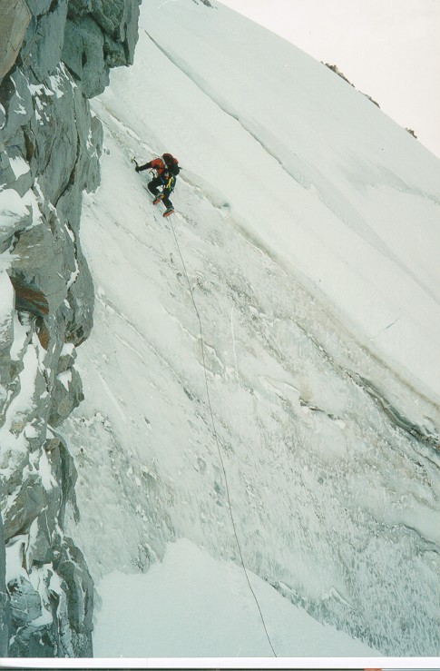
The skinny: A fantastic route that was still in really enjoyable shape, although the ice sections seem to be getting a little thin these days. The snow is soft and at some points only mildly consolidated but you can kick in steps fairly well. Getting into the third couloir was rather thin as well. Take pickets, not so many screws. Rock gear might be useful as well, we took some but didn't take a lot of time to seek out placements far from teh beaten route. All this said, the route was incredibly enjoyable. Great day, probably best route done to date. The Long Story: After scoping all the TR's lately and getting thwarted by crappy weather in the OR Cascades, my friend Pete and I decided to take a stab at Triple Couloirs as it seems as though everyone is doing it lately. We left PDX @8 PM, found a place to sack out in the 11worth vicinity, picked up some foodstuff and hiked in to Colchuck Lake for Saturday afternoon. We found the remnants of someone's killer tent site, re-set the walls and had a great view from the foot of the face. We set the alarm for 4a and sacked out. We woke randomly at 4:30 and tried to get our act in gear. Apparently I am NOT the only one who reads the posts on this site. There were a number of other parties aimed at 3C's- 2 two-fers and a trio. With all the posts about how stellar this route has been lately I can't say I blame any one of them. The party of three got in ahead of us, then Pete and me, then the other 2 parties of 2. Snow in the first couloir was a little soft and we were slow as we ran a running belay with a picket between us and then swapped lead when we ran out. The first trio was soloing their way up and pulled into the first crux pitch well ahead of us. They stitched it up while we took cover beneath the large rock below the first belay stance. The party of two following us (Scott and Jeff- if I can remember) caught up to us there. When the trio started their last climber, Pete moved up and set up the belay for the first ice pitch. Once set, I moved up onto the first pitch to see what I had in store for me. It seemed less scary than I thought it would be (I haven't lead very much AI or WI). The exposure felt impressive and I enjoyed the climbing. I ran out our ~55 meters and found a place to set up a belay, ending up just below the true crux pitch. Pete followed me up and set another anchor just below me, with our companions climbing up below him. I heard Jeff saying something about wishing he had another screw, so we lent him one. When Pete was set, I left a screw from my anchor as another point of attachment and went up. The crux pitch was really fun and had nice positive placements as well. There were a number of times where my picks punched through but I was able to find deep enough ice to stick confidently. I don't have a well developed sense of grading but I would guess WI2+, but probably not big enough or bad enough to warrant more. We topped out the crux and started up the second couloir just as Jeff and Scott threw a rope down to TR the party behind them. It was quite nice kharma all around... Pete and I headed up the second couloir, kicking steps into somewhat sugary, inconsistently consolidated snow. It seemed to hold well enough though. We continued our running belays and ended up simul-climbing to the bottom of the third couloir once we exhausted our picket supply. The exit was thin and the snow soft, but once out on that perch below the third couloir, it was like heaven. The steps from the trio (now LONG gone ahead of us) were appreciated and we made ok time to the top. The two parties following us caught up to us as we started #3, and we all paraded up the last pitches all together. As the group we hadn't met topped out behind us, it turns out ShredMaximus was on the rope as well. A quick break for the fat and slow people let the quick ones get ahead, we made our traverse and headed down the backside. Weather was perfect- clouds blowing occasionally through the area but high above the summit. It was cold overnight and cold enough during the day that even when the sun hit the route directly (albeit not too directly due to the aspect), I didn't have a big fear of sloppy, heavy stuff to slide in. The views were awesome, it was nice to hang out and be social with the other parties on route, and the route itself I found incredibly enjoyable. Drop me a line if you have any questions and I'll do my best to answer. I intend to post a pic or two and hope others do as well (Shredder, Jeff, Scott??) Chris ckouba@hotmail.com
-
Desey, I don't normally get on a bandwagon after it's left, but dude- suck it up. You weren't serious with that post were you? Get a grip and realize what you're doing. Conditions change with the wind- literally. All the beta in the previous posts seems awesome. If you don't like the conditions, make your choices. Don't go slinging mud at those who were only trying to share their beta. Get real man. Did you expect the yellow brick road? Handicap access? IT'S MOUNTAIN CLIMBING, in the WILDERNESS. Chris PS - Whoever made the analogy of alpine being sport-like was right on.
-
Well stated snoboy... The trick is to find a ski which will give the performance you're looking for as well as have the weight characteristics to make you happy. My personal setup is a pair of Dynastar 4x4 Verticals with the Titanal II's and TR12 boots. Entirely different feel to them than my K2 X15 with proper alpine boots, but that is to be expected. The 4x4's with bindings seem as though they weigh half as much as the X15's, yet they still give an acceptable performance when descending. The trick is to get the performance you want which will enable you to enjoy the environment you seek. Find your boards, mount your bindings (whatever style it may be)... Go have fun.
-
Iain- Per this: http://www.cascadeclimbers.com/threadz/showflat.php?Cat=&Board=UBB7&Number=135574&page=0&view=collapsed&sb=5&o=&fpart=1 Pole Creek Road is open to the trailhead... From the original post for the thread: "Also, you can drive to Pole Creek trailhead and there is barely enough snow to ski on at the start of the trail. I'd imagine that it is possible to drive to the Pamelia Lake trailhead for Jefferson as well." Are you thinking of heading that way and when? Chris
-
The local coverage: http://www.katu.com/news/story.asp?ID=53749 CK
-
cuz- We took rock pro (a selection of stoppers, no cams), but used none. We also used little of the ice (6 screws) and snow pro (4 pickets) we took with us (we were WAY over geared, but I prefer to have and not need than need and not have). As we climbed on the ridge, we used the rock to afford truly "natural" protection, slinging a horn or two and weaving the rope over/around others. It also had a tendency to get blown around up there, so be cautious that it stays where you want it. The thing I really enjoyed was the dry tooling aspect of the climb. I haven't ever really done that before and it was certainly the best way to get around up there. We used our ice tools (we both had C-M Quasar hammers and adzes) in all manners- hooking, camming, jamming... It was really fun! As the rock gets more snow in it, the character will obviously change and the cracks might not be so visible or accessible. I know that people have both rapped off into the Milk Creek Cirque area as well as traversed over the way you did previously to gain the summit ridge. I didn't really want to do either- I wanted to go via the ridge straight on. The descent from the col back to the glacier is going to depend on the conditions. We had good ice for the steep stuff and it was fairly straightforward to downclimb. I am making a guess here, but I think the reason many people descend the Whitewater is because they usually climb in the summer. If snowbridges are necessary for the route, they may be too soft by mid-day in summer. This mountain has been my opus- this was my 7th shot at it. Three times I have made substantial vertical progress on the glacier (including topping out twice, this trip and May '02) and each time we have descended via the glacier. There would have to be some serious motivation for me to descend via an alternate, especially when I know how long a slog it is to come back via WWG. My feeling is if I can get up the glacier and bergschrund, I should be able to get down it as well. Additionally there is reasonable access to the north ridge once below the schrund, so if the snowbridges of summer are melting you can always head off into the rock on the ridge. I anxiously await the trip when I finally do top out on this route. Colin felt pretty crappy about bailing off it, especially when we were so close. It is a patient mountain though, and has waited this long already for me. If you go over the holidays, best of luck and I look forward to the TR. Chris ps - there should be an attached pic of Colin downclimbing the wall above the schrund.
-
Hey all- Tried JPG with my friend Colin on Thursday and it turns out it's in fantastic shape. With the stretch of excellent weather we've been having and my incessant desire to top out that route, I was able to convince him that it would be a smart idea to head out to Jeff Park in the rain Weds afternoon to take a shot at the summit on Thursday. He was silly enough to agree. We left Whitewater trailhead around 2:30 pm and arrived in Jeff Park around 4:30 or 5. The trail was basically completely clear and we made great time. The weather was far from perfect but we had some naive faith in the weatherman that it would clear up. We found a spot in the trees on dirt next to Scout Lake and made camp as darkness fell. After chowing down a hot meal, we sorted gear set an alarm for 2a and sacked out by 7. Sleeping through the alarm, I woke at 3 and got us moving. A quick cold breakfast got us moving and when we poked our heads out of the tent, the skies were clear and the stars were shining beautifully. It was nice and cold and the snow we set out onto was wonderfully hard and crunchy. Navigation was very easy through the snow and trees to the base of the glacier. We geared up and stepped onto it around 5:30 and as the sky started to lighten, it became apparent that its crevasses had already started to fill in for the winter. We set out climber's left of center, but after gaining a little altitude we headed out into the center of the glacier. We ended up doing a number of end runs and a lot of poking with our ice axes but everything was remarkably solid where there was snow, and ROCK SOLID on the exposed glacial ice. The lower half of the glacier's slope was fairly mellow, but as we moved up to the upper third or so, it became a bit steeper. There were a number of crevasse fields that we navigated around and we negotiated some steep terrain to facilitate our passage, but we actually placed very little protection. I had a selection of screws and two pickets on me but placed only 3 screws as we simul-climbed to the bergschrund. Just shy of the schrund was a very steep roll. As I topped out on it, I hoped profusely that it was connected to the uphill side of the glacier via some sort of bridge. But that was not to be... To my right, the chunk we were on narrowed down to a chisel point like the bow of a large ship, and to my left it did largely the same, ending up in a small field of seracs that didn't have a line through them for us. Left was looking like the lesser of two evils and after a few minutes of traversing, I found a ramp to downclimb. At its bottom was a bridge in the crevasse, and it connected at a place where we climb out through a gulley on the other side. A few minutes of downclimbing and a little more traversing and we had it cleared. Shortly thereafter we pulled up under the bergschrund. This area was nothing like it had been in May of this year. LOTS of the snow had melted away and the headwall above it was much steeper. The schrund itself was largely filled with the spindrift being raked off the upper reaches of the mountain or blown in from the Milk Creek Cirque area, but there was a discontinuity from the top of that fill onto the steep firn snow above the schrund. Our best shot was to climb steep, hard, dirty ice just next to the left (east) tower (Smith Rock?). There was a ~20' snow ramp followed by ~45' of ~65° ice leading to a slightly gentler snow slope above. The ice took the tools nicely, with a little bit of dinner plating, but generally very secure and solid. I placed a single screw midway up the ice and another picket in the hard-pack snow just above it. With Colin clear of the ice, we again kicked steps in steep snow up to the col above the glacier. Gaining the col, we turned our sights uphill toward the ridge and the summit. I was moving onto new ground for me now... The ridge connecting the top of the glacier to the N-S ridge to the summit was REALLY interesting. It started out fairly mild and narrowed down to boot-track wide with enormous exposure on each side. We headed up and over it, climbing directly on it and heading for its junction with the other ridge. As we progressed, the climbing became more and more intense. I went from walking cautiously, to using tools as canes, and then to actual rock climbing on some pretty pushy stuff. I was using my gloved hands to hold some nice juggy grips, and when things got thin I used my tools as my hands- hooking rock flakes, camming the adze or hammer into cracks, using the pick however I could. It was a really fun alpine experience. There were numerous little faces to climb, some covered in a little snow and everything having a little bit of rime ice on it. The setting was fantastic and the weather was holding. We had some gusts (my guess is ~30mph) but nothing crazy. The route was awesome. As we moved along the ridge, I was constantly watching the next ridge to the summit, trying to figure out where we could ramp over to it. I was still on the ridge proper and about to downclimb a small face when my rope stopped moving with me. I would tug on it from time to time but over the course of a few minutes and a LOT of shouting in the wind, I figured out that Colin was done. Painfully, I was about a rope length away from hitting the mild ground of the ridge to the summit, but life goes on and the mountain will be there a while longer. I waited for Colin to pull in the slack and belay me back in. When I got to him he said he had reached his limit and didn't feel comfortable continuing. I told him no worries and said let's split if he wanted to do. And we did. Back over the ridge from which we came, down the rock faces and over the catwalks connecting us to the top of the glacier. Back down the steep face and downclimb the ice pitch to the schrund. We were able to move quickly once off of the exposed ridge. Heading down we stayed skier's right, hugging the margin of the east moraine. This was much more expeditious and continuous, with only one end run for crevasse avoidance. A very straightforward descent. We got off the glacier, took off gear, and called the people who were keeping a watch on us to let them know we were actually down off the glacier. We headed back to camp, had a hot meal and packed out in the darkness that evening- still under clear skies and stars! If the weather holds, the route is in really FUN shape right now for anyone possessing basic dry-tooling and strong rock skills. You should also be comfortable with large exposure and the other normal things one needs to be in tune with for climbing. Drop me a line if you want any other info. Chris ckouba@hotmail.com
-
Dox ROCKS!! Thanks man! See you sometime on Thursday. Chris
-
I need some help here. I was up with my dad on Eldorado this past week (7/10-7/12) and while returning to the Eldo Creek Basin, his camera came up MIA. The details: We last took a picture of the Bunny Rabbit Rock while descending the Eldo Glacier around 10am on the 12th, close enough to the ridge to be in its shadow. We were more than half-way down from the flat ice field to the gully up the ridge. We noticed it was missing when we were over in the Eldo Creek Basin at the by the first (highest) waterfall. Somewhere between there it was lost, and I believe it happened right by the base gully we used to come back over the ridge, still on the snow, on the Eldo Glacier side of the ridge. Turns out as I was stepping onto the rock and off of the snow, the bit I was standing on collapsed and I dropped into the moat. My dad arrested and that's when I think he lost it. The camera is in a light grey case which is about the size of a big cell phone. The case won't be easy to pick out due to its color. The camera itself is a black Fuji point and shoot, but you won't know that til you find it and look inside the light grey case. Inside is my dad's name (John Kouba) and number, except the area code is incorrect- 860 instead of 203. If anyone is heading up there or knows anyone heading up there, I beg you- please pass the word around and keep an eye out for it. The trip was one of the most fantastic things that my dad and I have done together and I'd love to have the pix from the camera (there is at least one exposed roll in the case and another in the camera as well). Please keep your eyes peeled from the Basin to the glacier. Should you happen to find it, please drop me a line. I'd be glad to arrange a gift certificate to a local restaurant or something for you. You can get me at: ckouba@hotmail.com If you need any other info as to where it might have been lost, also feel free to drop me a line.
-
I was there overnight Friday (27 July) and was turned back due to the weather Saturday am. It was perfect weather on the hike in, and the glacier looks like it has a line that will go. We were climbing by 2am but the snow was not firm... Not that we got to too much snow as we were climbing in the clouds. It was foggy, windy and raining, I was very concerned about finding camp in the dark/fog/rain. I was truly not enjoying myself. We turned around without so much as touching the glacier itself and promptly got a little lost on the way back to camp but eventually made it. Lessons learned: 1) Pick your weather, 2)bring and USE wands, 3) if weather isn't good, stay at camp, 4) remember to ask if you're enjoying yourself and if not- TURN BACK! But I digress back to route conditions. Doesn't look too bad. Large areas seemed to be completely melted out of snow/fern and had glacial ice exposed. The snow we did cross was very soft, so we had concerns for what might be higher- but there did appear to be a decent line around the schrunds (2, up high, and look passable both to the left or right of center- kind of ramp up on a slant). But remember- we didn't get onto the glacier and only saw it from a distance. Did you have any specific questions? Chris ckouba@hotmail.com
-
I was in a party on Early Morning Couloir overnight Sat-Sun. Didn't see anything out of the ordinary. Matter of fact, didn't see ANYONE... Where is this person missing from (east side/west side)? Curiously, was it a guy in a red Subaru wagon who wanted to ski the couloir? You can reply here or: ckouba@hotmail.com
-
What was your descent route?
-
Does anyone have any info on Kautz?
-
Mount Hood--Leuthold Couloir, the unroped route
ckouba replied to Joe_Poulton's topic in Oregon Cascades
So my (longwinded) two cents: If in doubt, stay off it with the beginner. I've sucessfully climbed the route twice, fully covered with snow in April '96 and this past January with bare rock and steep slopes for the traverse once on the summit ridge. With snow, it's fabulous (couloir and ridge)! This past January, the couloir was still fantastic, but the ridge was definately above where a beginner should be. There was very soft snow- hard to protect- and bare rocks to hump yourself up and down (yes DOWN) over. Add in variable wind gusts and the fact it's a 60° slide into the crater to your right or a X,XXX foot fall off the N side cliffs to your left and I'd be willing to bet you'd reconsider. For this recent trip, we (2 of us) were roped across the Reid and stayed that way all the way. Exposure was never really bad and max angle is rumored to be ~45°. The solitude and alpine feeling you get dropping over to the Reid is phenominal (leaving behind the SS crowd) and the couloir and Queen's Chair boast great vistas. There's nothing really technically challenging up the route except for negotiating the runnels- specifically the one in the hourglass- and the summit ridge depending on conditions. We did no running belays and set no pro... Until the summit ridge. We took our time over the exposed rocks on the summit ridge using our axes and body weight for the belay/anchor. The snow was very soft and I was thinking how inopportune it would be to test the anchor... So I digress. Depending on the conditions, my personal opinion is that it can be no more difficult than the SS route. There is still a very exposed ridge to traverse (actually, even Queen's Chair spooked my first partner too). In the long run, it's your ass that will be tying in. It is a fantastic route and wonderful experience to share, but I would want to share it only with someone who I can depend on to keep me from landing on the Coe. Chris ------------------