Leaderboard


Popular Content
Showing content with the highest reputation on 06/04/23 in all areas
-
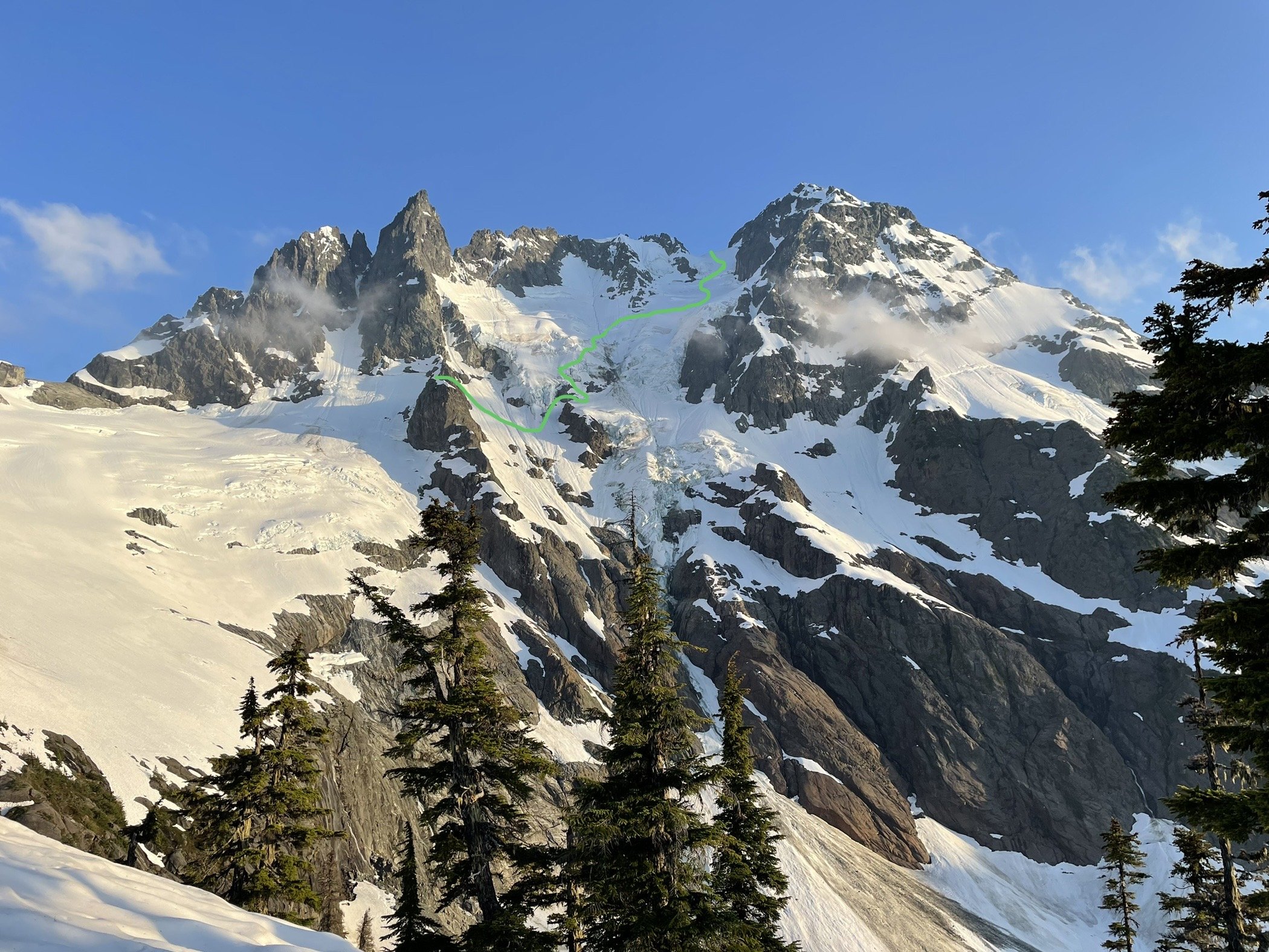
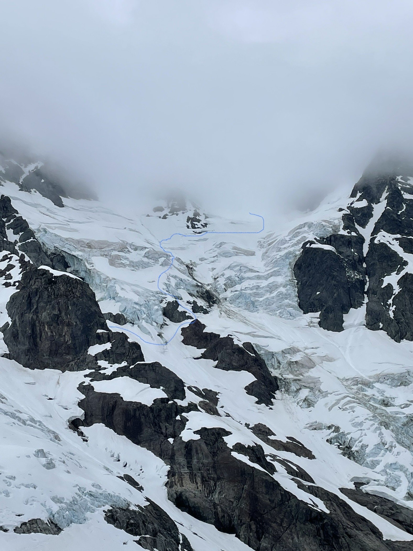
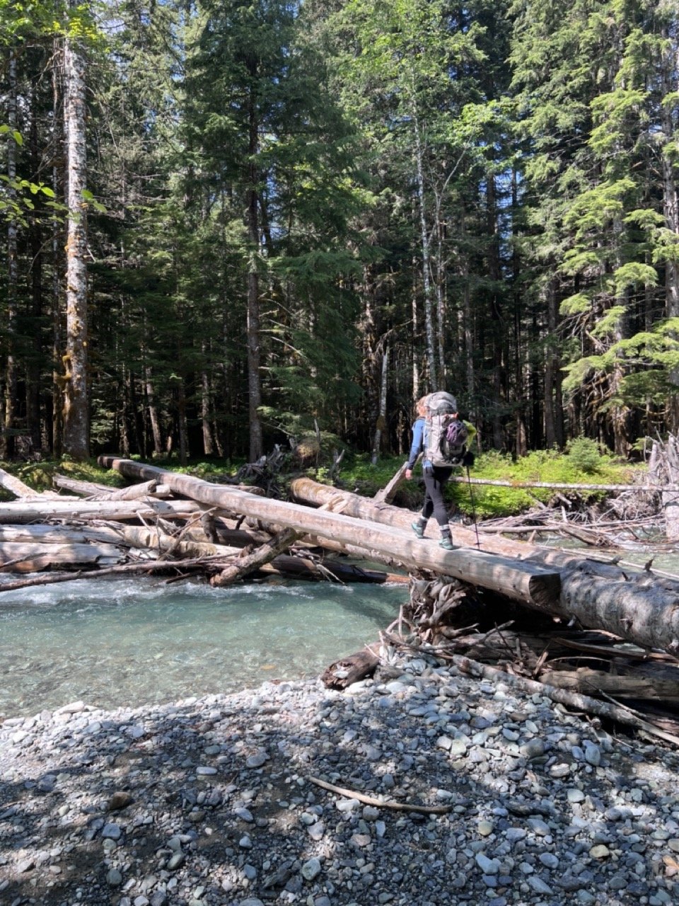
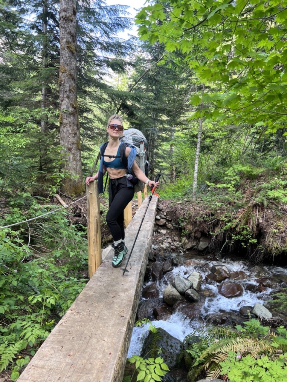
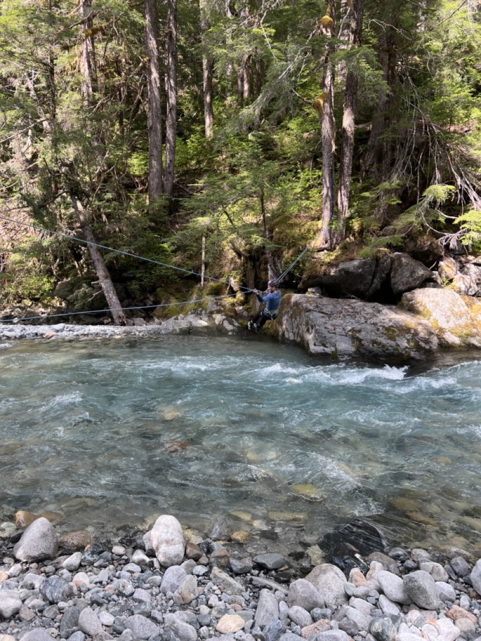
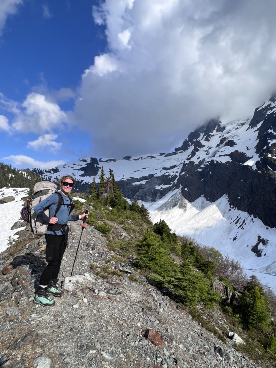
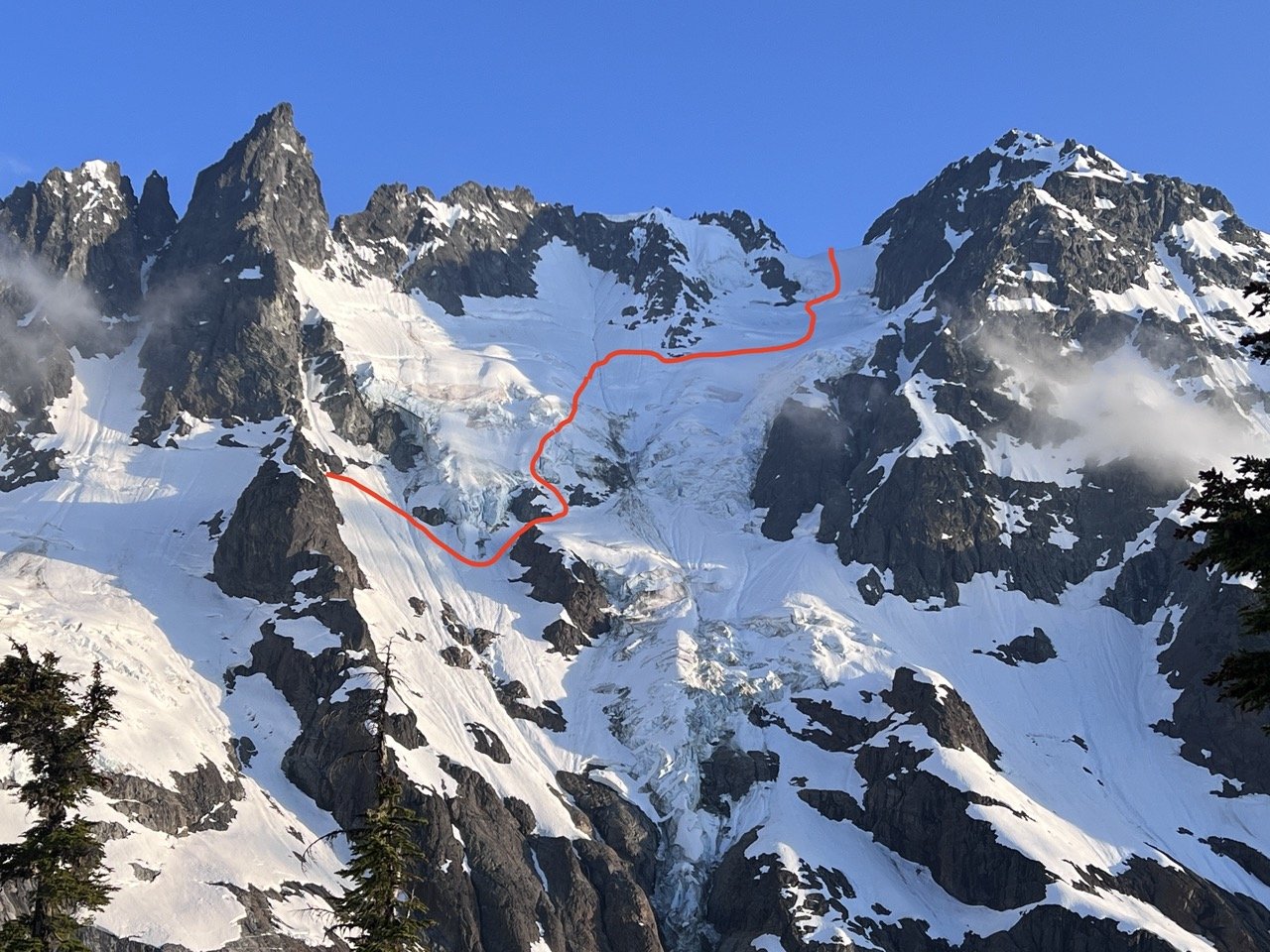
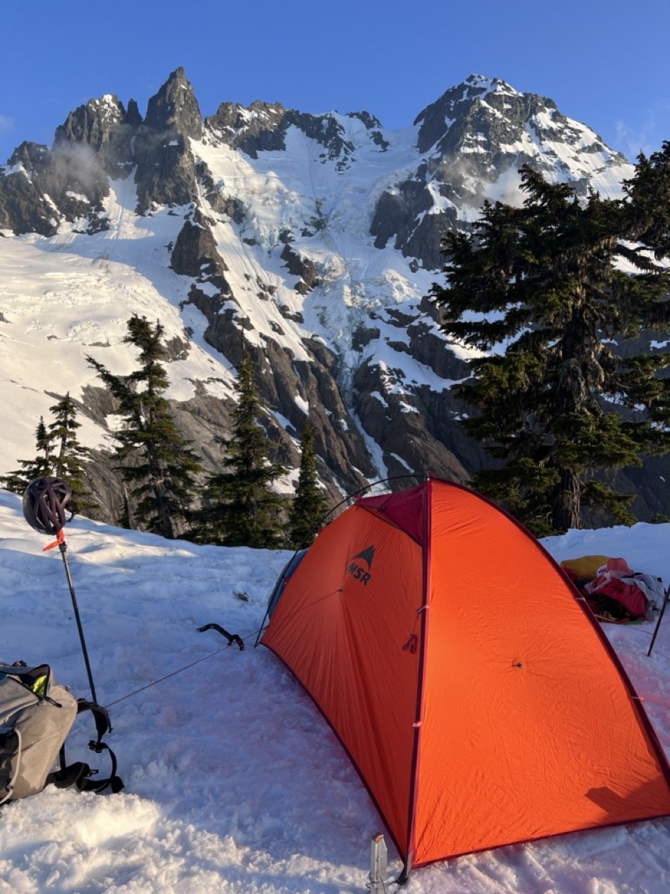
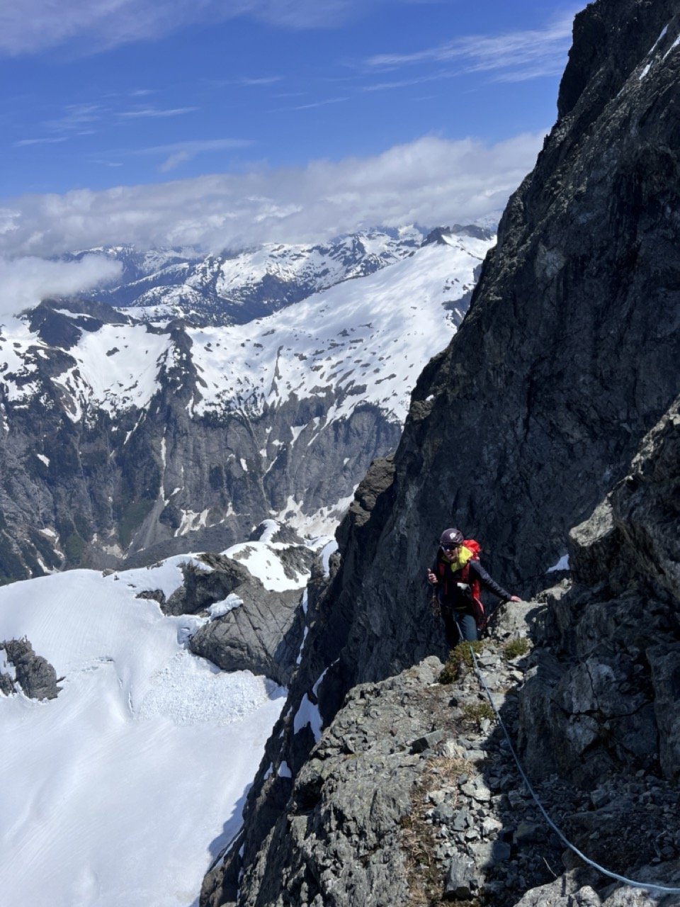
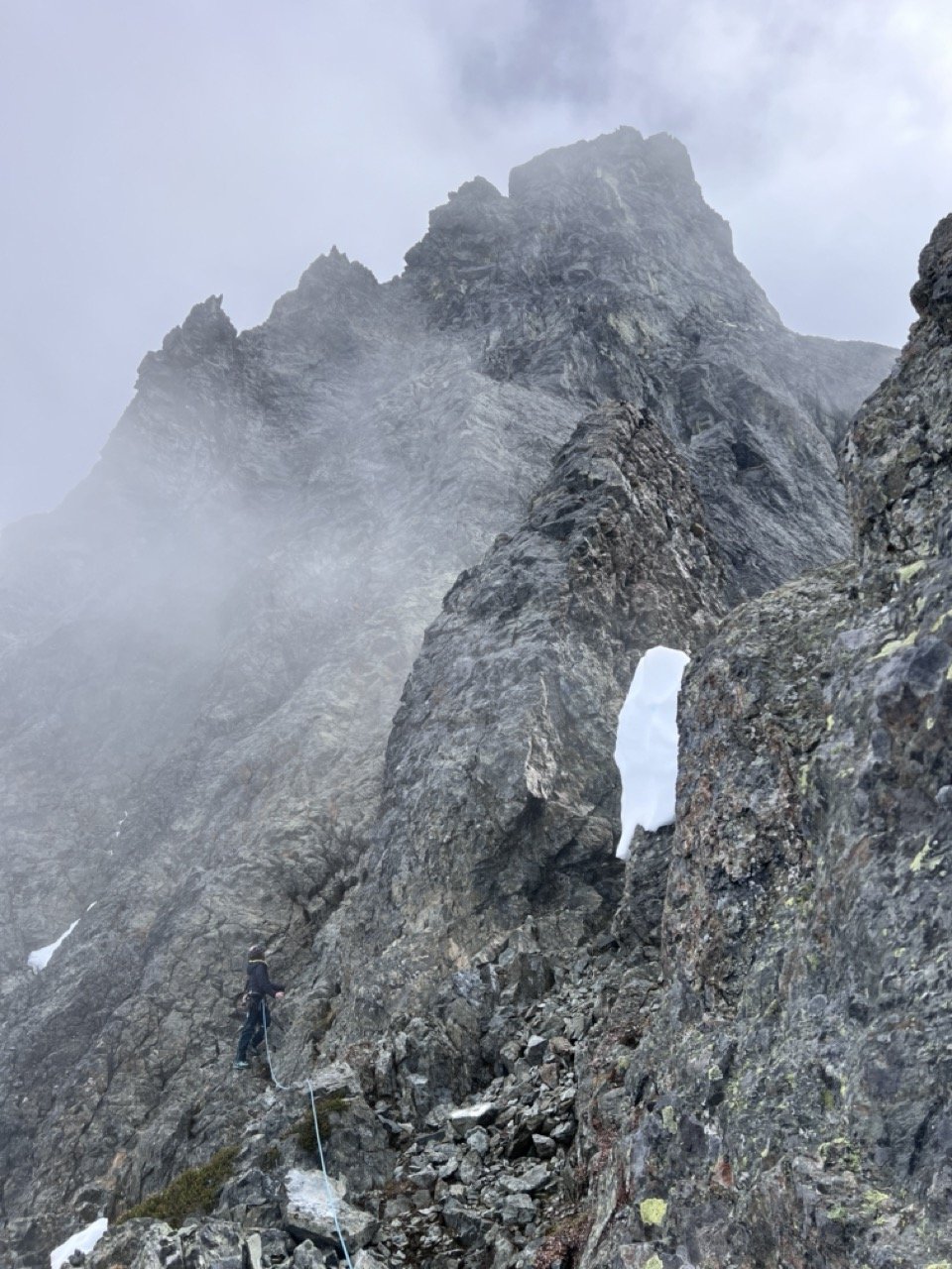
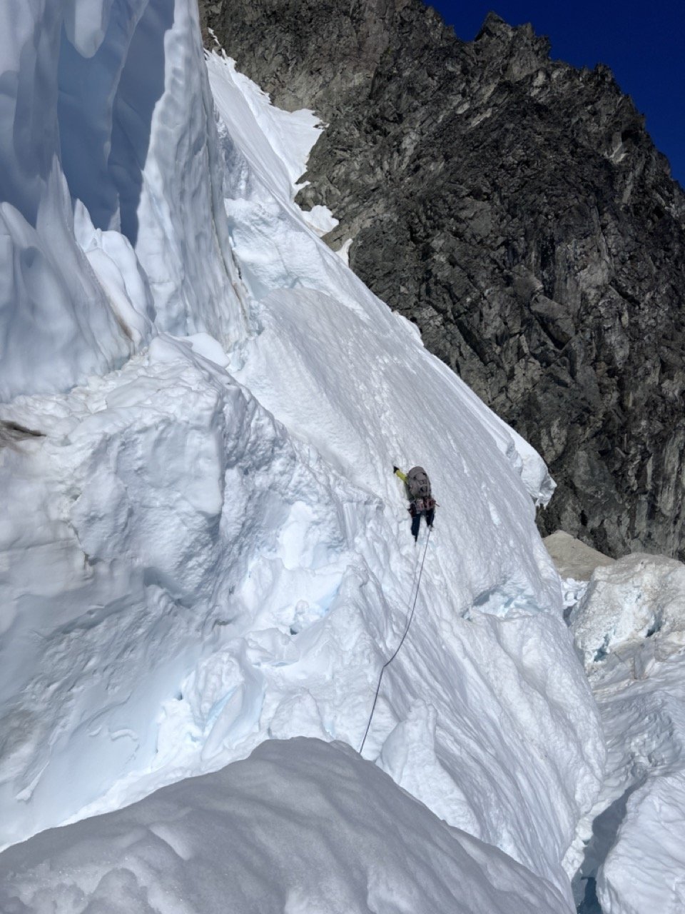
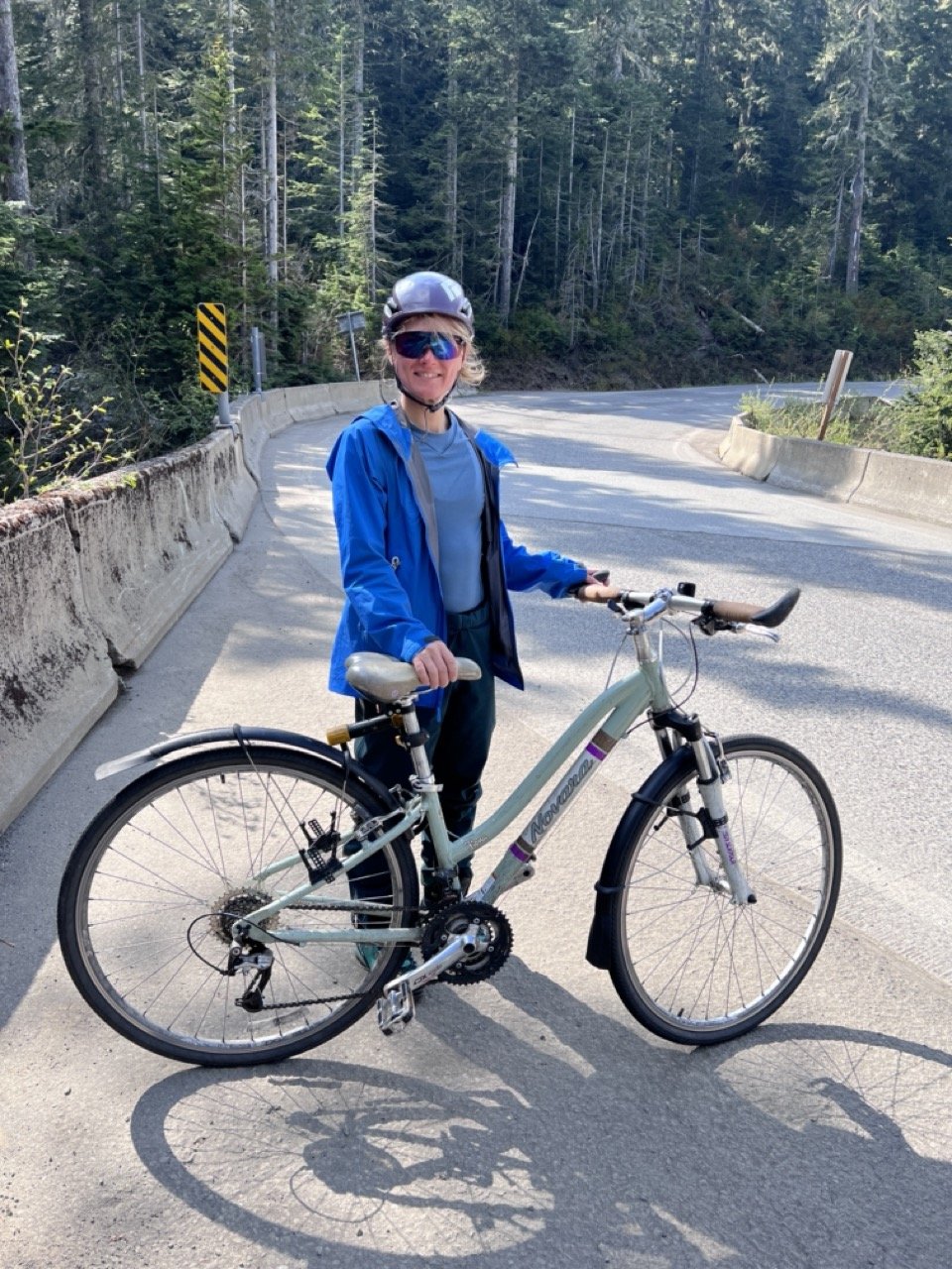
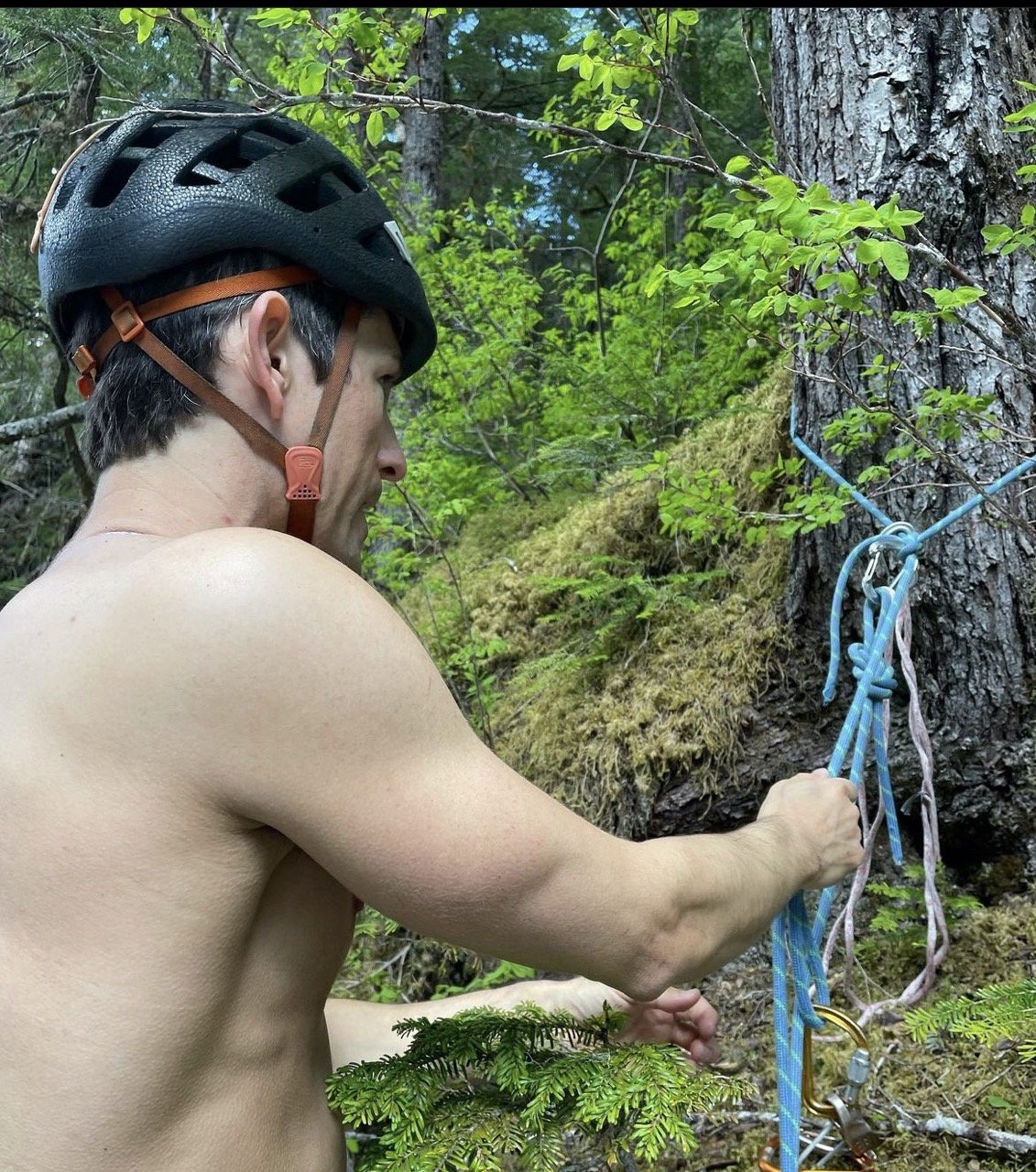
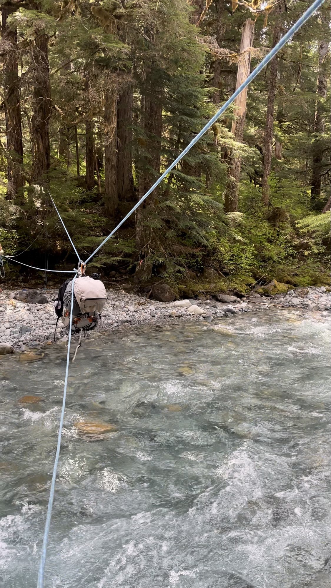
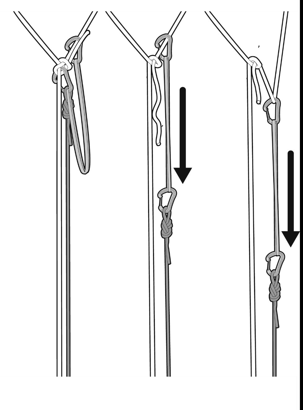
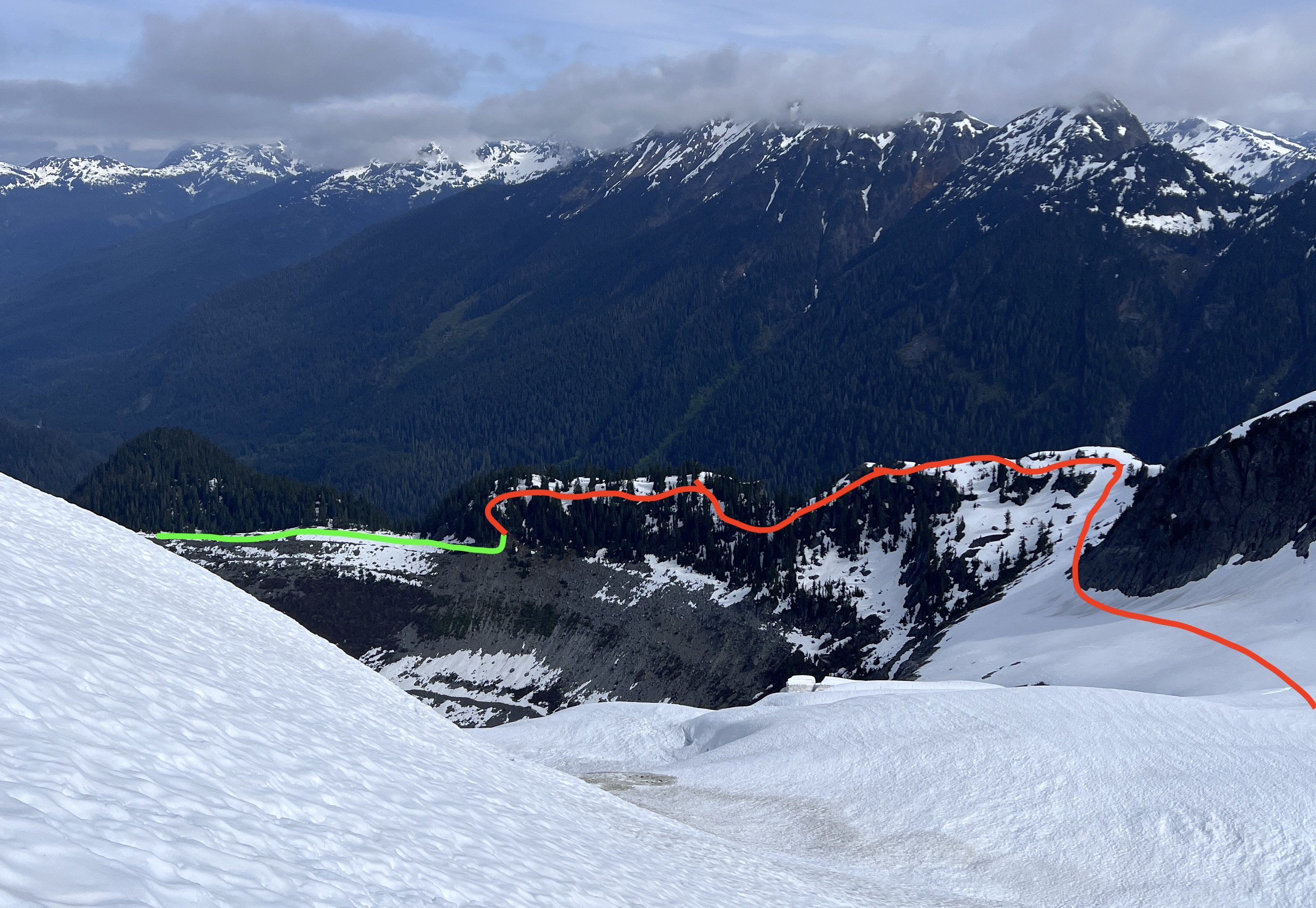
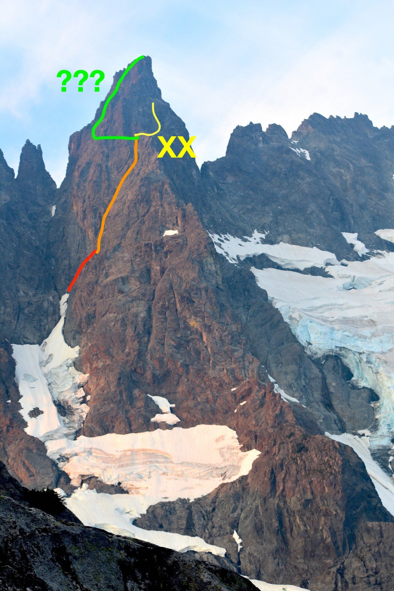
Trip: Mount Shuksan - Price Glacier and Nooksack Tower (attempt) Trip Date: 05/29/2023 Trip Report: Trip Dates: May 27 (Saturday) - May 29 (Monday), 2023 (3 days/ 2 nights total) Climbers: Jeff and Priti Wright Climb: Price Glacier (50 Classic) on Mount Suksan's North Face (successful) + Nooksack Tower (unsuccessful) along the way This report contains conditions on two routes: one is currently a sandbag and one is currently a featherbag...that way everybody has something to comment about! Descent Options: Fisher Chimneys, but there is snow on the trail all the way up Lake Ann according to the rangers on May 27. Rangers recommended floatation on the trail. White Salmon Glacier (skis), but you have a heinous bushwhack on the way out per this TR (link) "Once at the bottom of the glacier, we initiated the most miserable slide alder/thorny bush battle of my life. I was in a tee shirt, and was absolutely brutalized trying to fight through the vegetation with skis on packs." Sulphide Glacier (this requires a long car shuttle) but probably the easiest/fastest way off the mountain. Lots of traffic on Sulphide, no evidence of folks coming up White Salmon or Fisher Chimneys Memorial Day weekend. The snow on the Lake Ann Trail is perhaps scaring people away from Fisher Chimneys. Hanging Glacier Route No matter what you chose, make sure to have GPX tracks of all descent routes downloaded to your phone. You can find GPX tracks at caltopo.com or peakbagger.com. Logistics: Cache a bike or car at White Salmon Base (White Salmon Glacier or Hanging Glacier descent) or Bagley Lakes TH (Fisher Chimneys descent). We locked a single bike to a signpost behind a guardrail (very discreetly) near the White Salmon Base Area. It's a short/fun bike ride downhill and on the dirt road back to Nooksack Cirque Trailhead to your car. Note: White Salmon Base parking lot is closed for construction and no parking is allowed there. Therefore, I'd probably recommend Fisher Chimneys descent with a bike cache at Bagley Lakes parking lot. The road to Artist Point is partially open, so you can cache a bike higher up the road, maybe. You can also hitchhike down Mt Baker Highway then walk the extra 2.2 miles from the NF-32 turnoff to the Nooksack Cirque Trailhead. Park at Nooksack Cirque Trailhead and start from here. To get here, take NF-32 off of Mount Baker Highway, then branch off right onto NF-34 to the end of the road. NF-32 and NF-34 are dry, dirt roads in good condition currently. Plan for extra days out. The Price Glacier route can be trivial or it can be really complex and time consuming. Sandbag: In its current condition, there was no really technical terrain on Price Glacier (this will change day-to-day!). Just easy snow walking all the way up....much easier than the North Ridge of Baker. The bergshrund has a trivial crossing up the middle that might last a few more weeks. If it's out, however, then you're in for some mixed climbing out of the moat on the left or right side of the shrund. Featherbag: Nooksack Tower has a lot of rockfall, the worst rock quality I've ever experienced (even after the Southern Pickets Traverse!), VERY sparse protection, lots of required downclimbing, and difficult routefinding. Basically, YGD, and I don't recommend this peak at all to anyone, probably ever. I know it's a Cascade classic, but I was so shut down on it and also so unimpressed. It's just terrible...and too dangerous imo. All you successful Nutsackateers are free to comment about how trivial it is and how I need to harden up. Approach We got to the Ranger's office in Glacier at a leisurely 9:30 (they open at 8:00) but recommend you get there as soon as they open because stashing the shuttle/bike takes time. You might also want to consider getting your permit a day early, then sleeping at the trailhead to get an alpine start. Then we discreetly locked up a bike off the road near the White Salmon Base area and drove to the Nooksack Cirque TH. At the trailhead, head straight to the river and slightly downstream to reach an improved log crossing to start the Nooksack Cirque Trail. The trail has a few downed trees, but is generally in good shape. First improved log Crossing just at Trailhead Second improved log crossing along the trail...Priti doing her sexiest logwalk pose After reading this legendary trip report (link) from Pellucidwombat about their 9/2/22 Labor Day Weekend climb, we came prepared to encounter anything. This report is definitely worth a read. Mad props to those two for getting it done in those difficult conditions. I really feel like earlier in the season, the better for this climb. The original log crossing across the North Fork Nooksack River (now gone) has been there for years and years and provided access leaving the Nooksack Cirque Trail into the Price Lake valley. Pellucidwombat describes how they found a new crossing and provided us with the GPX point. Their new crossing is also gone (not underwater, but actually swept away). The best place to ford the river that we could find is at the original log crossing location (N 48.87097° W 121.61267°). We went up and down the river for hours to look for a new crossing. This location spot is the least sketchy spot to cross. A few parties have done it unroped this season (with skis!), however I thought it was sketchy and high enough to cross on belay then set up a tyrolean for the packs. Our tyrolean steps: Set up one end of the 60m rope to the tree as a retrievable bowline (equivocation hitch could also work, but this thing give me the heebie-jeebies, and it might be harder to release after a tensioned tyrolean). Practice this at home first! Tie-off of the bowline tail as as a Backup/Failsafe. Cross the river on belay with a bight of rope attached to your harness. Note: bring a bight across, not just the other end. Keep both ends of the rope at the start. Once across, make an anchor around a tree (2x 120cm runners work), then bring the anchored end of the rope tight and tension it with a simple Z-pulley (I used two micro traxions since they release easily). The taut, Tyrolean line goes from the Bowline to the Z-pulley. If you happen to have a GriGri, it is much safer to use the GriGri as a progress capture pulley than the micro traxion (link). Technically, Petzl says YGD if you use a micro traxion as a progress capture pulley for a tyrolean (link). Of course, a regular/passive pulley (such as a locked-open micro traxion) with an old-school progress capture hitch (Bachmann, prusik, Valdotain, etc) also works well and is safer. The free end of the rope going back to the start gets pulled in and attach a backpack to a figure-8 on a bight. Clip the pack onto the tensioned line and pull the pack across with the slack line. With a 60m rope, the person at the start should hang on to the free end of the rope to pull the carabiner back across. Therefore, you have a tensioned line and a slack line (tether). Re-tension the Z-pulley between each crossing. Once both packs are across, follower confirms that the Removable Bowline is set up, removes the Backup, then Tyroleans across the tensioned line (nothing fancy, just hand over hand with a locker on their belay loop) Release the tension on the Z-pulley. The Bowline (or EQ Hitch) won't release while the line is tensioned. To release the micro traxion (or GriGri or progress capture hitch), you'll need to tighten the Z-pulley slightly in order to open the toothed cam (practice this if you don't know what I'm talking about). Pull the pull side of the rope to release the Bowline (or EQ hitch). Note: this may be a *vigorous* pull! If you've set up an EQ Hitch, practice ahead of time what it feels like to pull on each line alternating between each bight release. Releasable Bowline (pictured) from 'Down' by Andy Kirkpatrick: the most effective ghosting technique, due to the fact most climbers know how to tie a Bowline, it’s safe if carried out correctly, and it works. In this set-up, a 120 cm sling is being used. You can use a longer sling (240 cm) or cord, but 120 cm is the minimum length. Anything shorter and the Bowline will probably not fully release. Also note that the tail of the Bowline must be long enough to tie an effective and secure the Bowline (30 cm long), but not so long that the tail does not fully clear the Bowlines when the RELEASE rope is pulled. There is flagging at either end of this river crossing location. From here, follow frequent flagging up the slope through mild bushwacking and bootpack trail until it opens up and you get your first glimpse of Price Lake. If you lose the flagging, retrace your steps and try to get back on course (GPX tracks are helpful). This section of the approach would be much harder without the flagging, so please try to preserve it. This section from the North Fork Nooksack River up the slopes to the Price Glacier moraine is fairly trivial, but it is STEEP! Once the slope opens up, you first traverse across talus and boulders to eventually gain a lateral moraine. Follow the moraine bootpack trail (green line pictured below) until you are under a cliff band. Immediately gain the cliff by the first gully (red line pictured below), then follow the undulating ridge (many bivy sites here) until you are forced to go down onto the open snow slopes. We bivied on top of this ridgeline the first night, but a strong party can easily make it to the Nooksack bivy which is recommended so that you get on Price Glacier early the next day. Priti and I originally planned to spend one day on approach, one day on route (Price Glacier only), then fly off the summit the morning of the third day. There was a team of 2 who were one day ahead of us (Eli Philips @eeelip and Ian Mock @cascade.ian) who impressively planned to do Price Glacier with skis on their backs and also tag Nooksack Tower along the way. When we got to the Nooksack bivy, and saw their tracks going up the Nooksack Tower approach gully (and after watching them effortlessly float up the Price Glacier in just a few hours), we couldn't let these guys 1-up us! So, we changed the plans and spent all of our second day questing up Nooksack Tower with just the pictures of the pages from Selected Climbs. The route line in the book is a little deceiving since it goes straight up the "central couloir" which looks to have overhanging terrain, and not the 4th-and-low-5th class terrain advertised. If we had done some research ahead of time, these two trip reports would have been handy from 2013 Jason G (link) and 2014 Dave Shultz (link). Eli and Ian (as we found out later) also didn't have enough beta, starting too low in the approach gully and bailing after getting spooked on runout terrain. I think we started at the right spot which is to go as high in the approach gully as possible then start up the right side at some TAT (don't get suckered up the chimney directly up the middle). The route has 3 distinct sections: low angle ramp/slabs (red line below), low angle couloir (orange line below), then a sharp traverse out left to more low-angle ground to the summit (green line below: the presumed route which we did not explore, so do not trust this green-line-overlay!). The start of the route has a few body lengths of wet, low-5th ledges with good gear in a corner which soon eases to low 4th class and little protection. Pass a large rappel anchor at the top of the slope where the angle steepens, then make a short traverse out right under the steepening wall and turn the corner to continue up and left into a wide gully (orange). Continue up this gully which gradually steepens to gain the ridgeline and a prominent notch where you get amazing views of Price Glacier. Side Note: A neat option for future parties might be to bring all your kit up to this ridgeline (top of orange line), cache your packs, summit Nooksack, retrieve your packs, then make two 30m rappels down the other side of the ridge to the top of Price Glacier which would bypass much of the heinous descent and shorten your total trip. The only downside is that you'll bypass the fun lower 2/3 of the Price Glacier route. From the ridge, we accidentally continued out right onto the West Face (yellow line). The route got difficult, loose, with bad protection (spooky!), so we tucked our tails and bailed. A key bit of beta from JasonG's TR would have helped us tremendously: "For aspiring Nooksack Tower ascensionists ... traverse hard left [at the ridgeline] across 3 or so ribs as soon as feasible once you've climbed up and right from the snow gully. Then, basically traverse left until you get to 3rd/4th class gully that will take you to the summit. This is key, don't be pulled up and right by the numerous rap stations-these led to the North face . Alpine Select gives this variation a 5.7/.8 rating and it felt quite spicy in boots." Note: I presume this North Face route continues straight up from the orange line. Photo above is taken from pelluciwombat 9/2/22 TR and not representative of current conditions. Nooksack Tower Descent: Selected Climbs warns that the descent off Nooksack Tower takes longer than the ascent, which is true! We only had one 60m rope so we made a couple short rappels with a lot of belayed downclimbing between stations. Two ropes would definitely had been nice! Be prepared to freshen up lots of anchors with new tat and maybe some leaver nuts since a lot of the anchors are snafflehound-tattered stuff from JasonG's 2013 ascent. Priti nearing the prominent notch at the ridgeline. We went right (West Face). North Face is pictured in the center (possibly). Likely, the Beckey route is way left around the other side of the skyline ridge. We bivied our second night after our 12hr attempt on Nooksack Tower at the Nooksack Bivouac (the prominent saddle under Nooksack Tower). Right now it is flat and snow-covered for several tents comfortably. Note that late in the season (according to pellucidwombat), this saddle is just a knife-edge snow ridge and not conducive as a bivy site. There is another nice bivy site on flat snow on an obvious rocky outcropping on route just after traversing out from the Nooksack Bivy. With fresh steps to follow, the Price Glacier itself was a non-event, taking 3-4 hours to ascend the face. Pure Type 1 Fun! We may be the first people in history to have steps kicked and the proper route found for them on Price Glacier! Luxury. No gear was placed, no crevasses were fallen into, and we got the muscular endurance workout we were hoping for. We each carried one picket and the follower carried one screw in case of a crevasse fall. The bergshrund crossing was easy, located in the middle (pictured below). I would almost feel comfortable solo'ing the Price Glacier in its current conditions (from a technical standpoint) except for the fact that it is still a glacier with several potentially dangerous crevasses, so a rope and glacier travel gear is still recommended at the very least. Above picture: Priti crossing the bergshrund in trivial conditions. This is traditionally the crux of the route. If there is no way to cross it directly, then mixed ground must be taken across the moat on the right or (more commonly) left side. Once on top of the face, it is necessary to make a wide circumnavigation to join the procession of Sulphide climbers. Instead of the wide circumnavigation, we followed Ian and Eli's clever shortcut, traversing high under the summit pyramid, then ascending to a notch in the South Ridge then descending slightly to join the main route to the summit. The summit pyramid is in easy conditions now, with snow most of the way to the top, with just a short section of 4th class rock (a few body lengths), reaching the summit at noon after starting out at 6:00AM. The descent went smoothly, then Priti grabbed her stashed bike and picked up the car, for a multi-sport weekend! Thanks North Cascades! Gear Notes: Single rack to #1 (used on Nooksack, didn't place any rock gear on Price...still a good idea to bring some rock gear for Price just in case, small cams are nice on Nooksack) 2 pickets for glacier travel (one on each person at all times, more pickets if you're not comfortable soloing "steep" snow) 1 knifeblade (didn't use) 10 ice screws (didn't place any, good to bring maybe 4-5 at all times) 12 runners (used a few to make anchors on Nooksack Tower, bring LOTS of anchor material and nuts if you plan to climb Nooksack) small rack of nuts (great anchor gear on Nooksack Tower) V-threader Rappel device for Fisher Chimneys rappels (good to have for emergency anyway) we did not bring rock shoes but I might have liked them on Nooksack (although traditionally it's been climbed in boots, but I'm not hard enough) crevasse rescue kit single hiking pole each (very nice for all the snow walking) 2 alpine ice tools each (Petzl Gully would be perfect) tent was very nice to have on exposed bivy spots (as opposed to open bivy or tarp) Floatation (snowshoes? ugh) *might* be nice for Lake Ann Trail, but I think skis are maybe a bit contrived for these current conditions considering how much bushwacking you do on approach and descent. We didn't bring any floatation and were very glad we didn't. 1x 60m rope (a pull cord or half/twin ropes would have been nice for Nooksack Tower) Approach Notes: Nooksack Cirque Trail
 1 point
 -
Thanks for making my bridge look proud. You guys crush.1 point