
Leaderboard


Popular Content
Showing content with the highest reputation on 10/15/22 in all areas
-
Thanks for the post. Nice pictures too. I've been thinking about this peak. The views in the Olympics are the best part.1 point
-
Trip: Mt. Index - Traverse - North -> Middle -> Main Date: 7/7/2010 Trip Report: The Mt Index Traverse – North, Middle, and Main Wayne's trip report can be found here. Wayne and I linked up on Monday for a great traverse of the three summits of Mt. Index. The trailhead was packed when we pulled up, due in no small part to decent weather and it being the tail end of a four-day Fourth of July weekend. Lucky for us we spied a parking spot right next to the TH sign, and saddled up. We arrived at Lake Serene a little over an hour later. People were everywhere, but our destination was the W side of the lake which appeared to be deserted. We made camp on a flat slab and went to bed early. Tuesday morning, we were up at 6:00. It was a perfect bluebird day.. just what we needed to dry out the wet vegetation that existed from the days prior. By the time we were moving at 7:30, the sun was blazing and things were drying out nicely. We ascended talus slopes to the NW end of Lake Serene, where we crossed over a rib and began to ascend a steep drainage running off of the N peak. We encountered very steep brush and heather slopes with rocky steps. The rock was surprisingly solid where we needed it. We roped up at the beginning of the NE Rib arete, and remained roped up until the false summit. The climbing was exposed and enjoyable. Wayne preparing to tackle the brush on the N Face of N Index. The view up the N Face from low on the route. Looking down. The town of Index and Index Town Walls from the N Face. Typical climbing on the N Face of Index. Mt. Persis from somewhere on the N Peak of Index. Wayne climbing solid rock on the NE Rib of N Peak. Wayne approaching the summit of N Peak. The summit of N Index. Impressive relief. Once on the false summit, we traversed class 3 terrain to the true summit. The views from the summit are amazing, revealing a huge jumble of jagged rock and steep, relentless and incredible cliffs. The traverse to the Middle summit looked improbable at best – very steep, very rugged everywhere. We looked for a summit register, but could not find one. We stayed for about 15 minutes on the summit drinking water, eating, and enjoying the impressive views. Looking down more than 4000’ to the valley below. Wayne readying the rappel. Notice the old tat behind. None of it was fresher than 5 years old. Steep traversing. Wayne rappeling on the way to Middle Peak. More downclimbing. Gorgeous. Views along the traverse from N to Middle Peak. Relief ... A long way down. A view of the Middle Peak from the traverse. Wayne on the ridge crest. Good grief, more relief! Wayne. Middle to Main. Soon we were packed up and heading down towards the Middle Peak. We descended about 200’ of class 3 into a W-facing fully. From here, we found a ledge that traversed around to the SW side of the 1st gendarme below the N summit. From here, we made a very committing rappel into the abyss. Rigorous routefinding ensued and after three more rappels and quite a bit of downclimbing, we finally made it to the intimidating N-Middle notch. It is hard to describe the ruggedness of the N-middle notch. Vertical walls surround and drop away 4500’ to the valley bottom. Of all the places I’ve been in the mountains, this is one of the most rugged places I’ve been. From here, we didn’t have a whole lot of info on what to do next, but a steep wall directly in front of us looked like it might offer a good route. Wayne led off (thanks Wayne) up mid-fifth rock with sparse pro (solid, but few fractures). After about 50’ of climbing, we came to an overhang. The overhang looked difficult, so we descended about 20’ and gained a gully system to climber’s right. Super sketchy, fairly sustained and difficult climbing ensued (~5.9) under sparse pro. This pitch was a full 60m and we were glad to have our ‘A’ game on this day. After this pitch, we worked our way up and over a gendarme, before dropping down to a most perfect bivy platform on a flat slab between the two summits of Middle. The views from here were amazing, and we we fortunate to get a lot of time before the sun set to enjoy them. Sunset from our bivy spot. The view to the N from our Bivy. This morning we were moving by 7:45 and summited Middle via some involved routefinding, but generally staying E of the crest. We found two summit registers on Middle Peak, one from Don Goodman and Chris Robertson in 2004, and one buried below the summit rocks in an old Kodak film cannister. Routefinding our way to the Middle Summit. Wayne approaching the summit of Middle Index. Steve who? The Main Peak as seen from Middle Index. From the Middle peak, the terrain doesn’t relent one bit, and we were once again working hard to find a good route. It seemed like there were seldom ever two ways to climb something, it’s either you find the magic door or you don’t. We wound up mainly downclimbing Middle Peak, but did a few raps too. We found running water here. A little moat crawling between Middle and Main. Running water below Middle and Main. Wayne on solid rock. Wow! Lake Serene framed through the gap. The last notch between Middle and Main is also in an amazing position, and the views are unbelievable. Here, we climbed up and left on relatively easy rock (5.5), and then up again to a belay. From here, we stayed on the crest of the Wedge Gendarme until we could climb up and right towards a prominent gully on climber’s right. We crossed the gully high on a loose bench, then continued on up steep heather slopes to the summit of Main. Traversing ledges below Main. More enjoyable climbing on solid rock. A look back at Middle from Main. More solid rock! Wayne approaching the summit of Main Index. One last look at beautiful Lake Serene. This traverse epitomizes (to me) the ruggedness the Cascade Range has to offer. It is unbelievable to me that the first ascentionists ventured onto this traverse with archaic gear and no information whatsoever, not even the knowledge that the route would go. It is an extremely impressive alpine route – one that will test every skill you have. The trip out to the car was hot, but we eventually made it. Thanks to Wayne (again) for being such a great partner.1 point
-
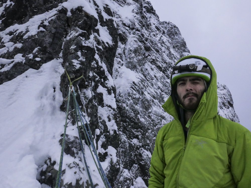
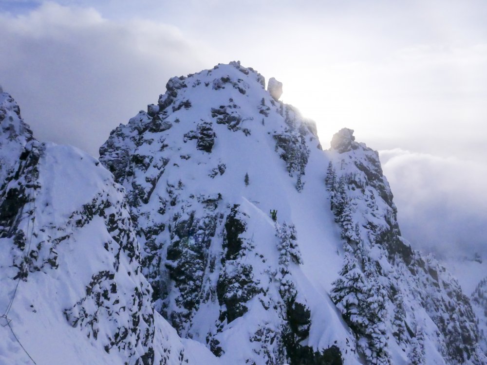
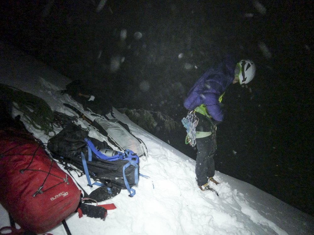
Thanks for writing this Sean! It's an honor to be apart of the first full N-Index winter trip report. This route is so much bigger than I could have imagined. In it's current condition there is a direct ice line that bypasses the N-rib mixed climbing and goes straight up some sweet looking alpine ice. I wish we would have taken this, as it would have shaved probably an hour or more off of our climb. I would probably give the route in these conditions AI3- M5. Strava Track HERE And the only decent photos I got from my camera. Racking up at the base The belay below the N-rib Sean leading across the gendarmes
 1 point
 -
Climb: Big Four-Direct Tower Route Date of Climb: 7/30/2005 Trip Report: For about a decade, I have wondered what the most prominent Big Four Tower would be like to climb. During a bit of thrashing about looking for Ron Miller's 1971 line up the feature, I was drawn to a steep slab on the north face. Only a few years ago, it seemed to be wet almost all summer. Due to the last parched few years, however, the place dries out after a few hot days. In May 2004, Stephen Packard, James Lescantz, and I started what would become many trips up this fine wall. Last weekend, myself and Eric Gamage topped out after dragging a bivy to 1/2 way the previous day. Gear should include tiny widgets to 4", and many extendable slings. When dry enough to climb, there is no water on the route. As the lower portion of this face is in the shade most of the day, it is perfect for those days where Darrington or Static Point are entirely too warm. Generally, the climbing is on extremely hard conglomerate, with excellent face climbing in equal ratio to sinker hand/fist cracks. Overall, 2500 feet of climbing is required to reach the summit of the tower. As in other areas of Big Four, brush in gullies can be abundant and "vigorous". In the middle of the tower there is perhaps 300 feet of hellwhacking to overcome. The route likely shares upper pitches with the Miller/Guydelkon 1971 route. Approach via Ice Caves Trail, contouring east until reaching a chasm seperating the first and second towers. Go down hill about 200 feet, and look to access a bench below obvious steep slabs above. 200 feet of 4th class zigzags gains the start of the first pitch. Pitch 1: Somewhat flared but fun chimney/fist crack. 150', 5.8, gear to 4". Nice belay ledge. Pitch 2: Steep and grooved headwall with consistent 5.8+ moves for nearly 155', draws. Semi hanging belay @ 2 bolts. Pitch 3: More steep slab with interesting huecos and strangeness @ 5.9+ or .10a, 150', small tcu's + pinky tricam+ draws. Belay at good ledge. Pitch 4: Work up and right over a bulging slab with bolts (5.7). Runout 5.5 leads to a cedar tree ledge at the base of a thin fingers dihedral. #2 LoweBall protects the initial moves well. 70'. Pitch 5: Nice 5.8 dihedral steps right to the arete after crack runs out. Bolts and thin gear lead to a prominent OW pillar crack (5.7+). Belay @ 2 bolt station on sloping ledge. 145', gear to 4". Pitch 6: Amazing 5.8 hand crack for 75 feet. Belay @ large cedar with slings. Pitch 7: 4th class up and left through blueberries to reach an easy chimney notch. Belay at tree with slings. This is "1 acre ledge". Move belay up and right (100') to a cave. It is advisable to rope packs up here, rather than spelunking. Once through the cave, go up the vegetated, yet delightful gully (3rd/4th) ~ 300 feet. Pitch 8:Blocky face and chimney climbing accesses the spacious ledge below the upper slabs (5.7). 4" gear helpful. Pitch 9: A few unprotected face moves reach another great handcrack. Move left to a 2 bolt belay when crack runs out. 150' Pitch 10: Staying near crest, low to mid 5th arete is climbed to a cedar bush with slings some 150' out. Pitch 11: Working right, follow features to a unique 5.4 wide crack complete with chockstones. Step left, and over small roof to belay at a nice ledge with cedar. 150' Pitch 12: Follow white slabs within 30 feet of chasm view. Belay at small tree with slings 150' up. Hike up into the fields, or step left for great views of Sloan Peak. Scrable for about 10 minutes, using ramps to access the area below the summit spire. Pitch 13: On the west face of the spire is an excellent and somewhat hidden 5.8 hand crack. Rap sling in place. Descend the route. Slings/anchors in place. Cheers, Mark Hanna Gear Notes: Med to large rack to 4", many extendable slings, lotza H20 Approach Notes: ce Caves Trail-Mountain Loop Hwy1 point


