Leaderboard


Popular Content
Showing content with the highest reputation on 07/01/22 in all areas
-
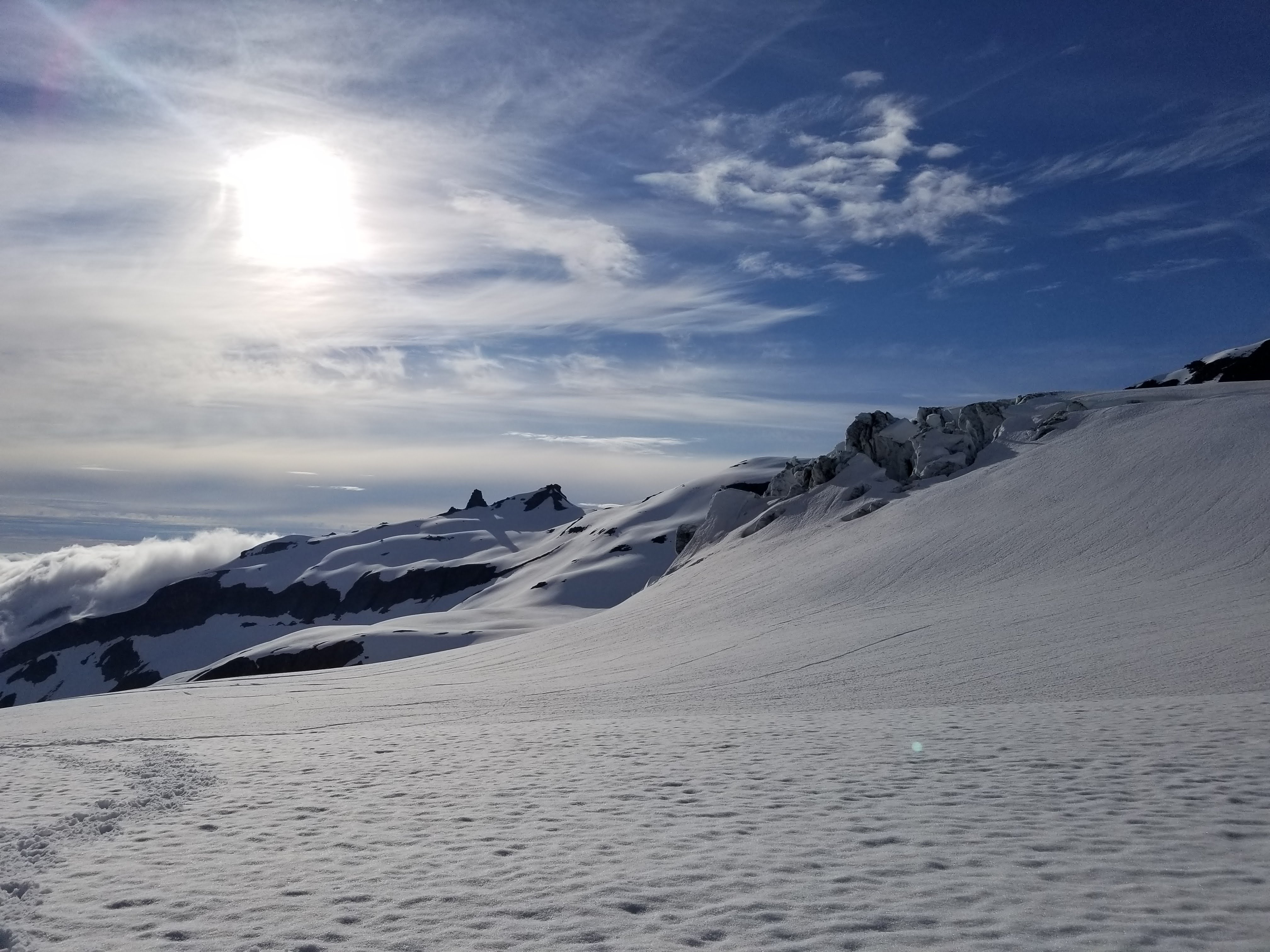
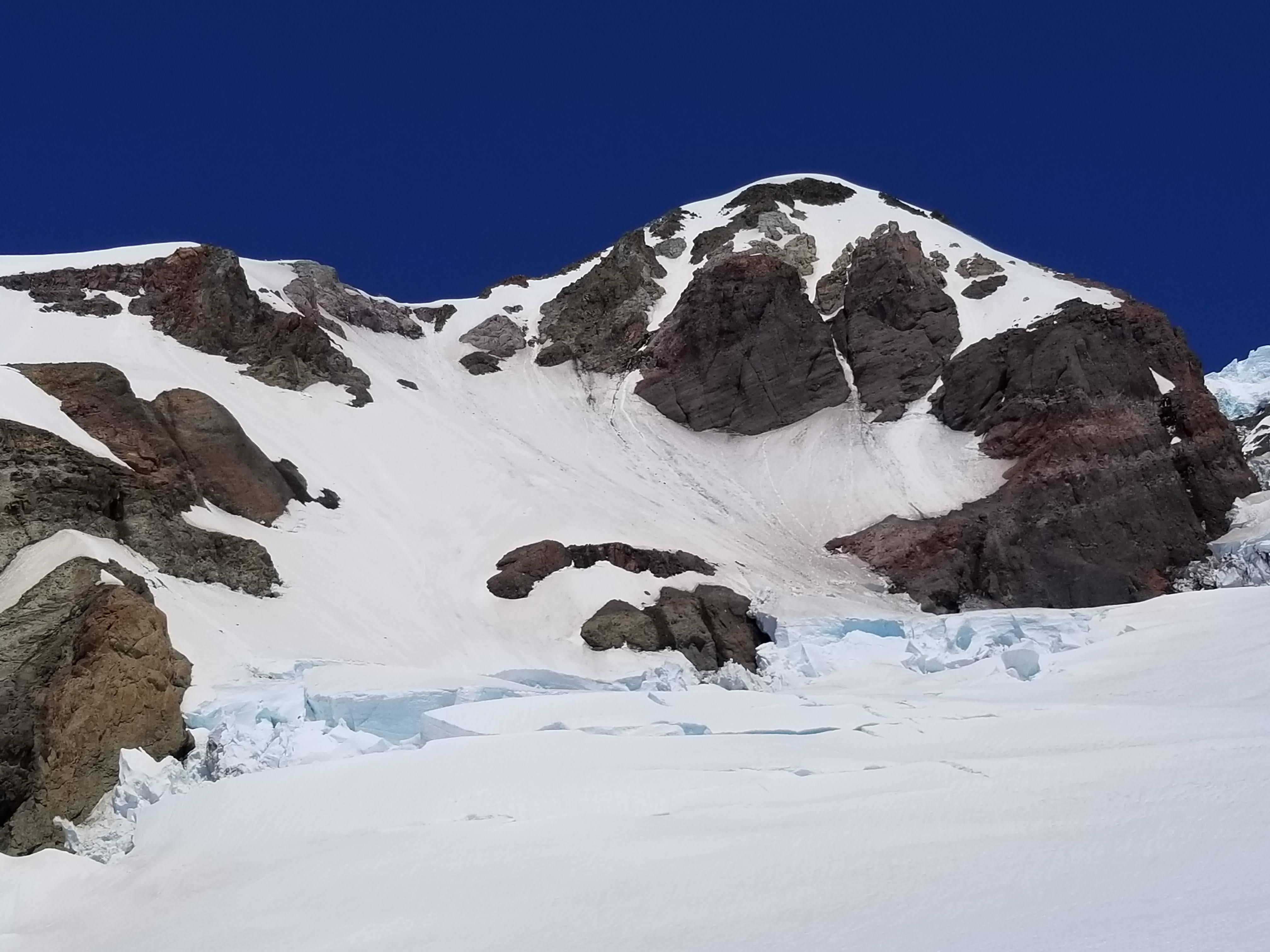
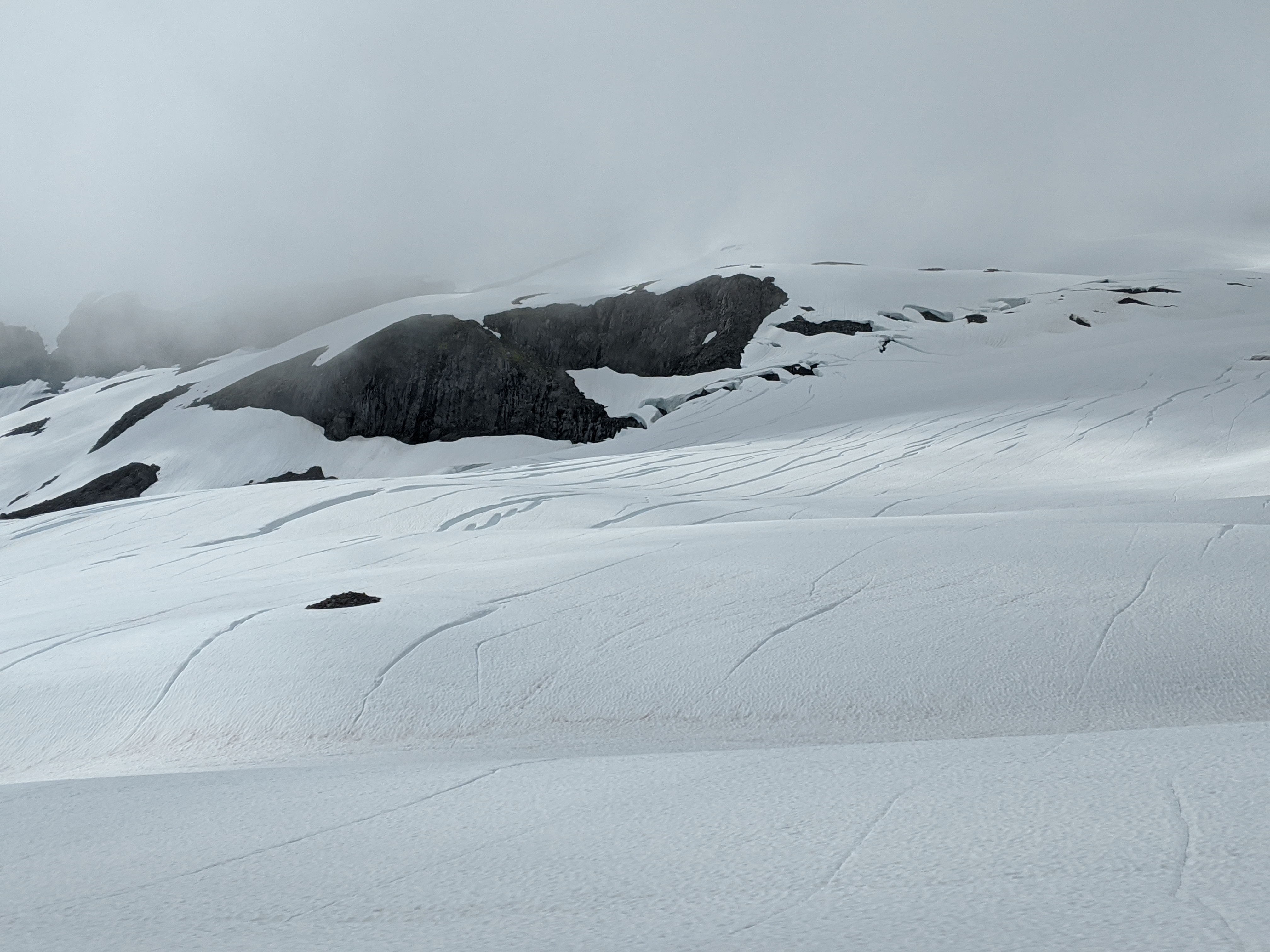
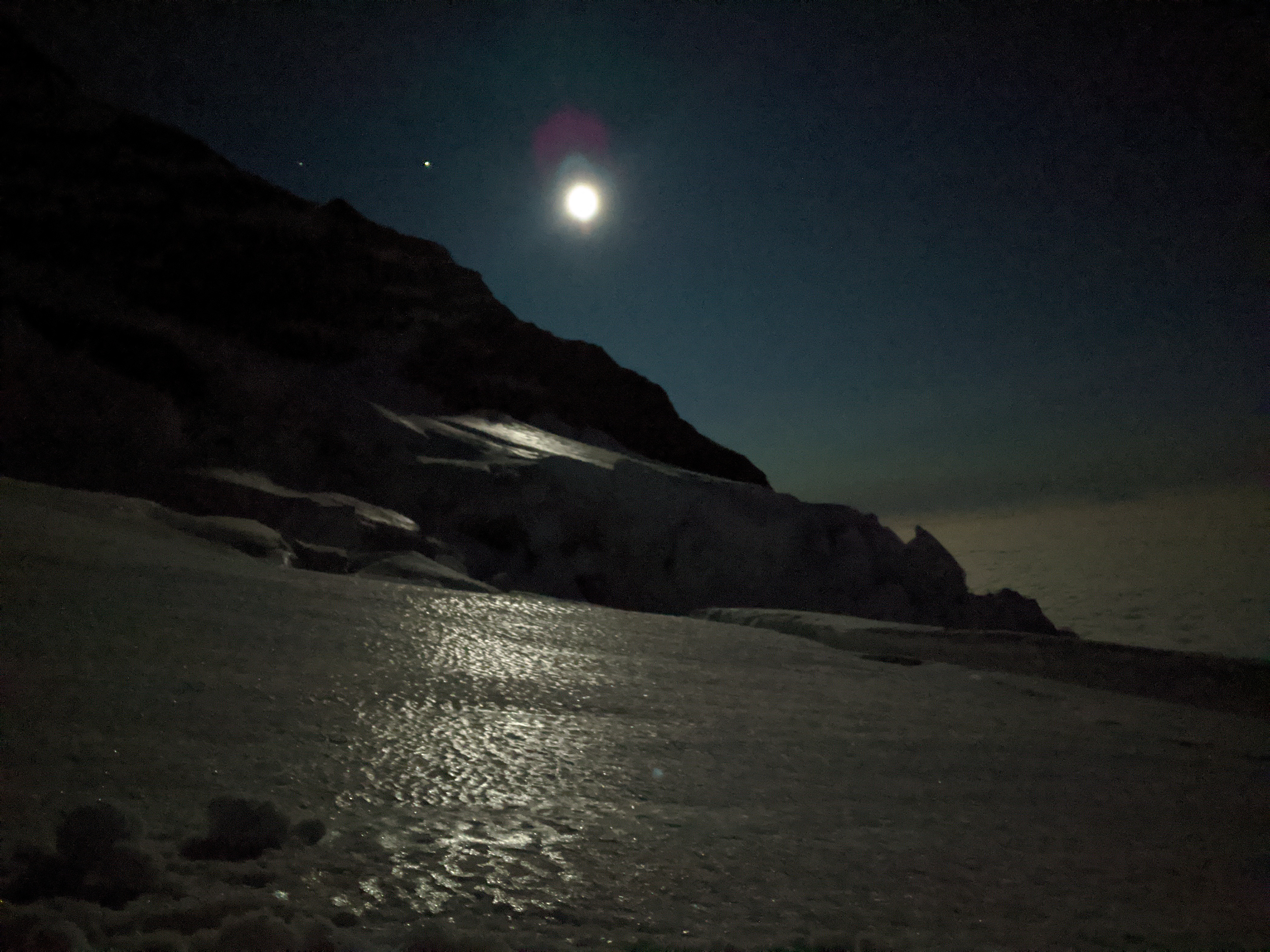
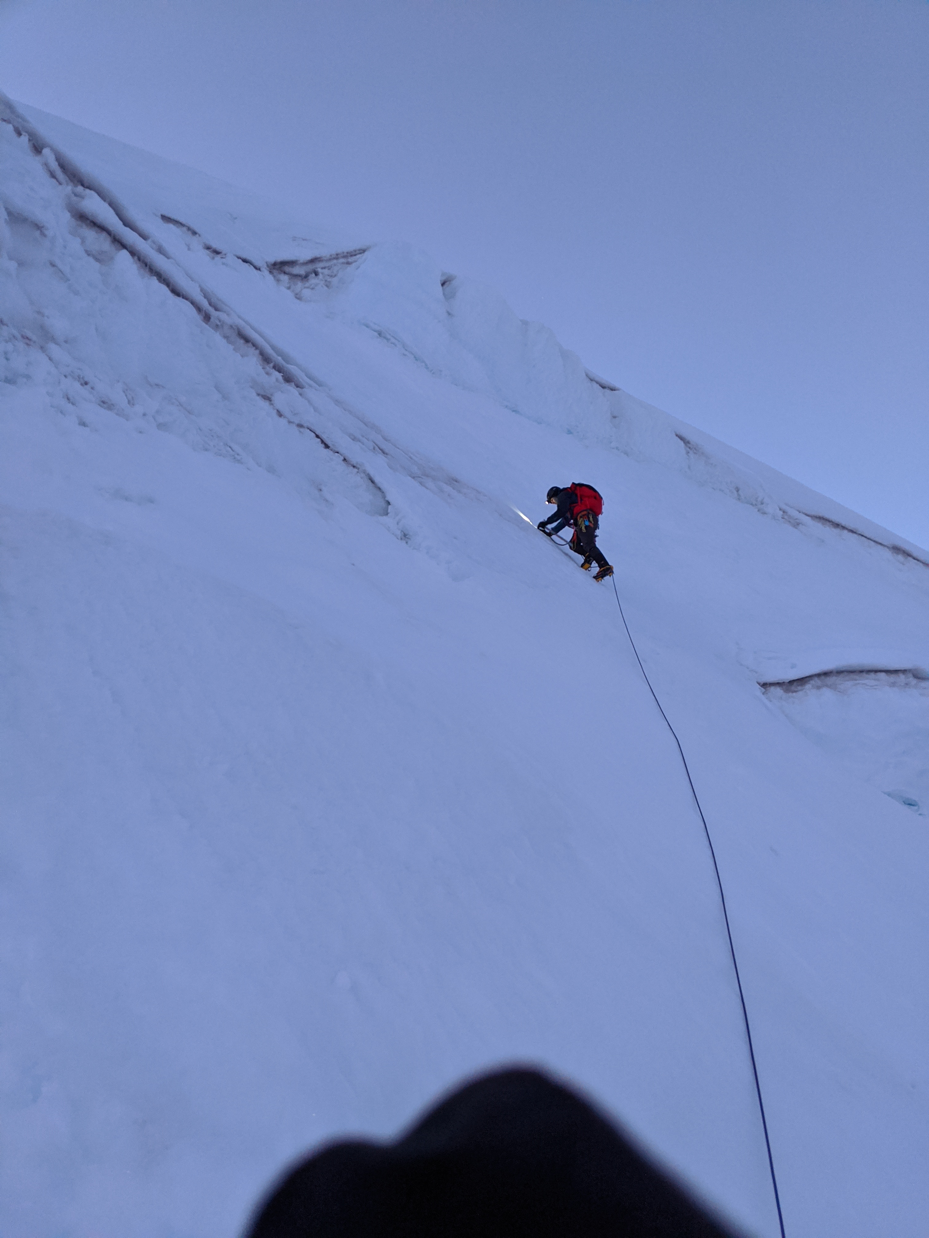
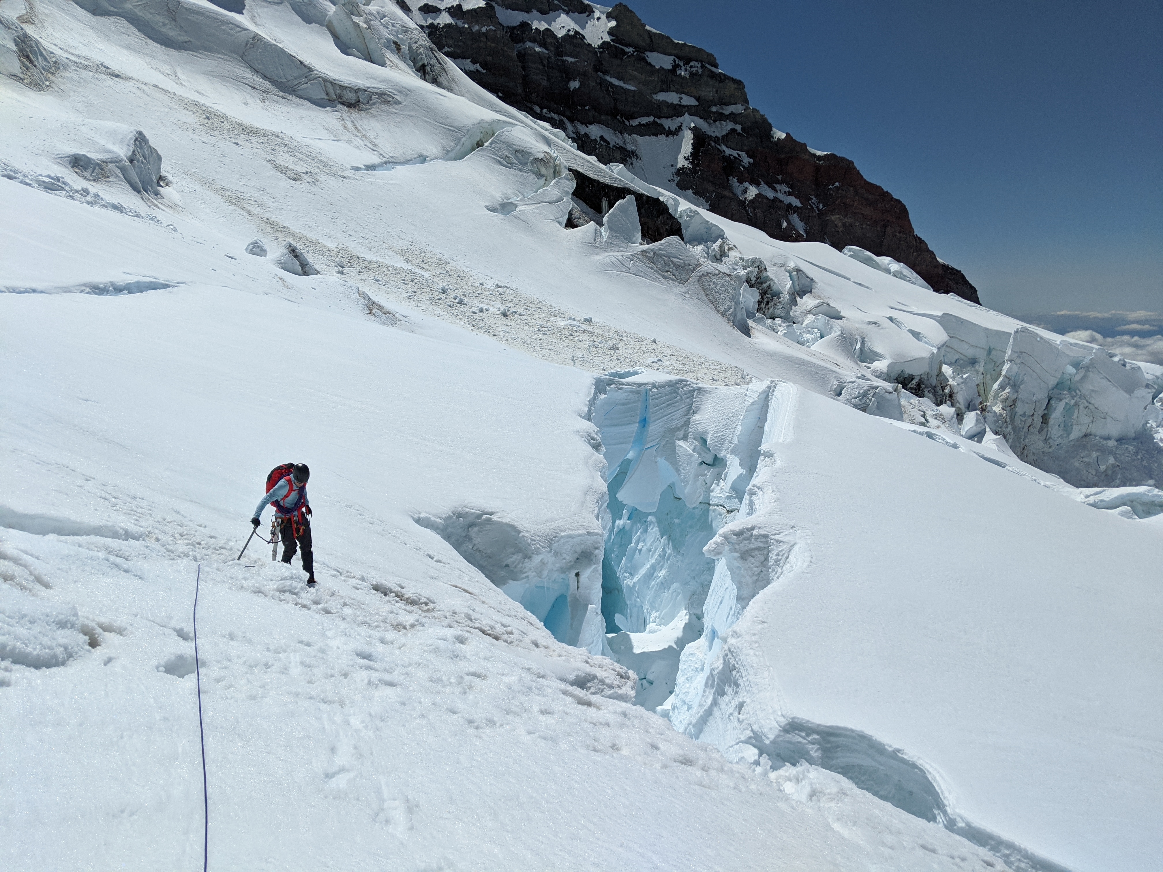
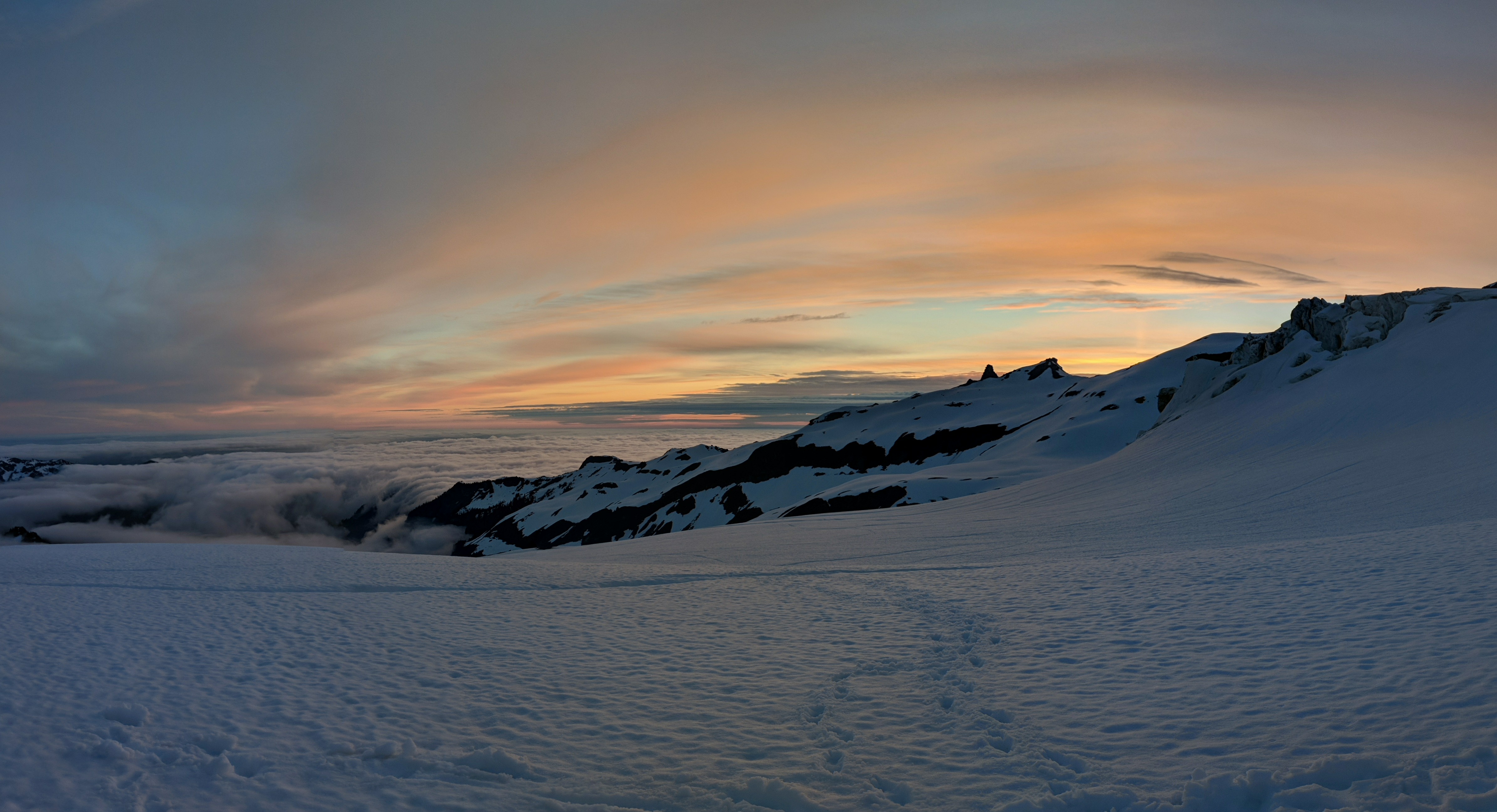
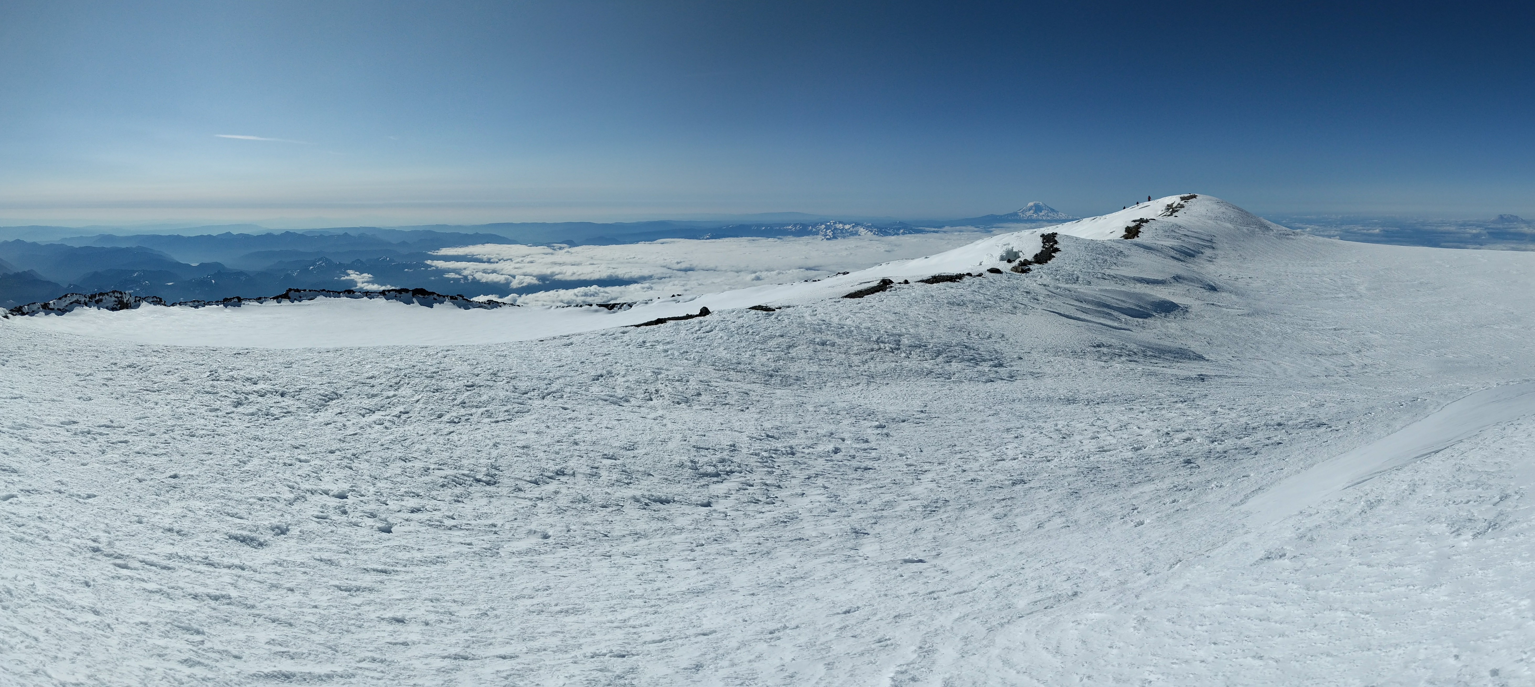
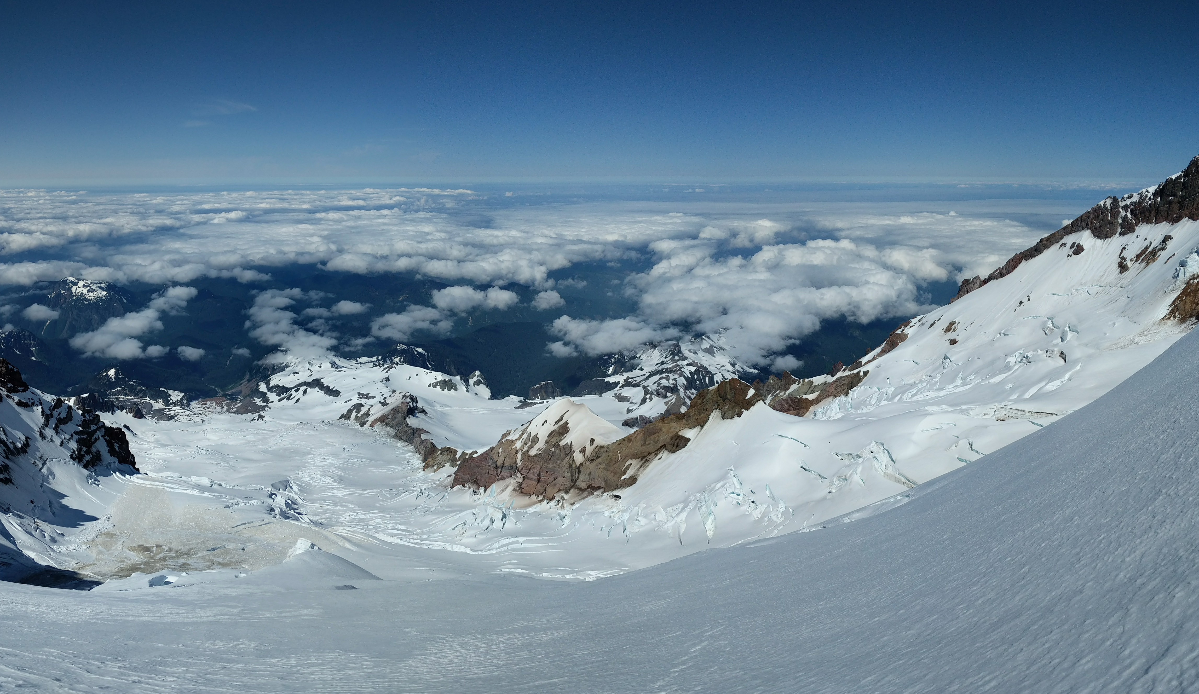
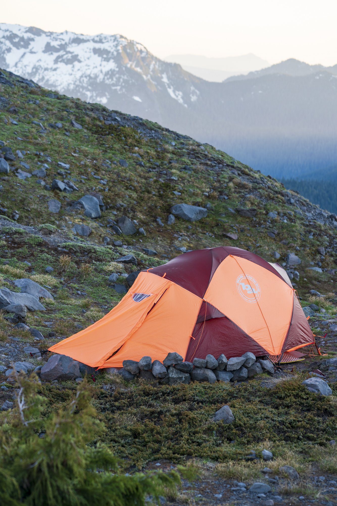
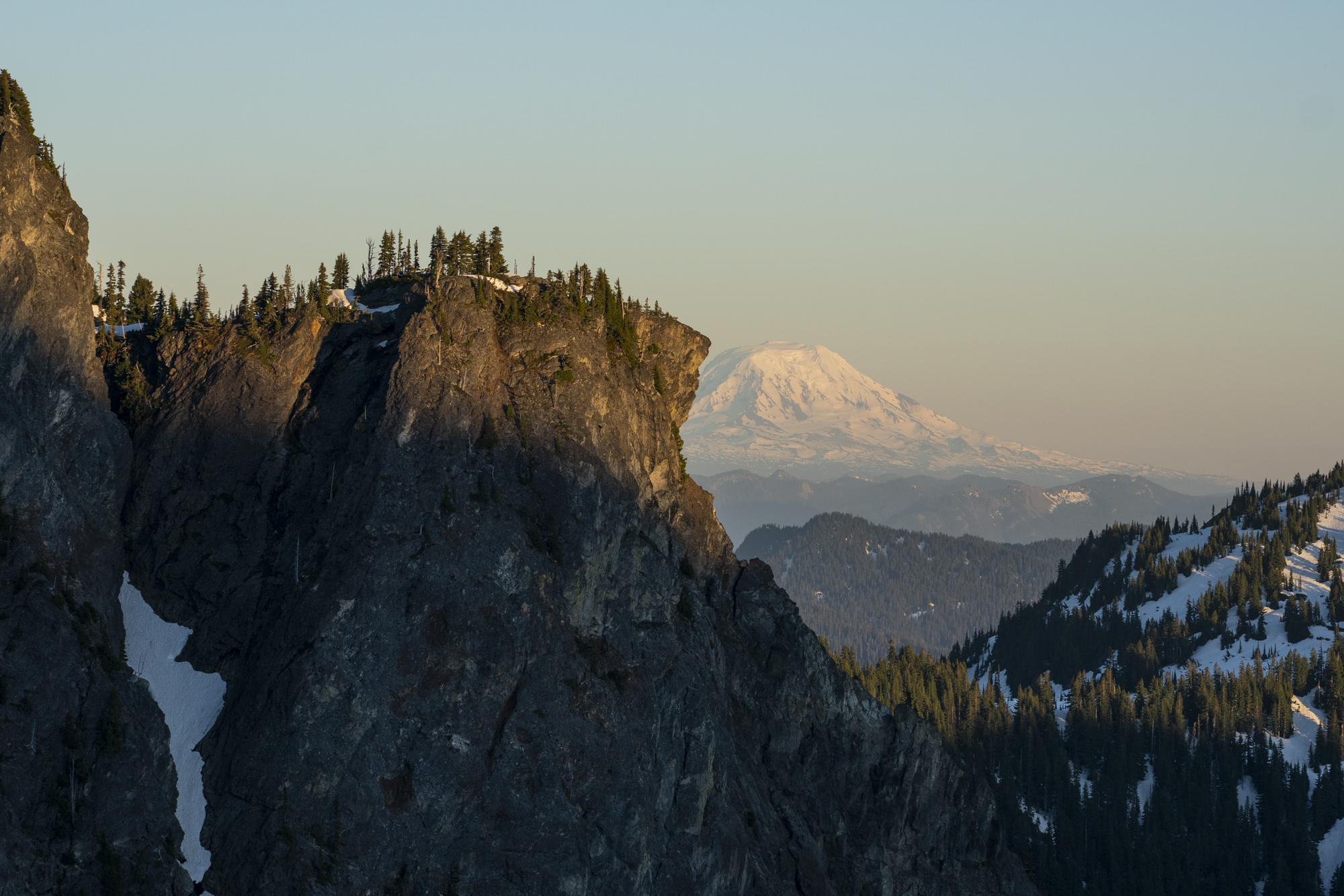
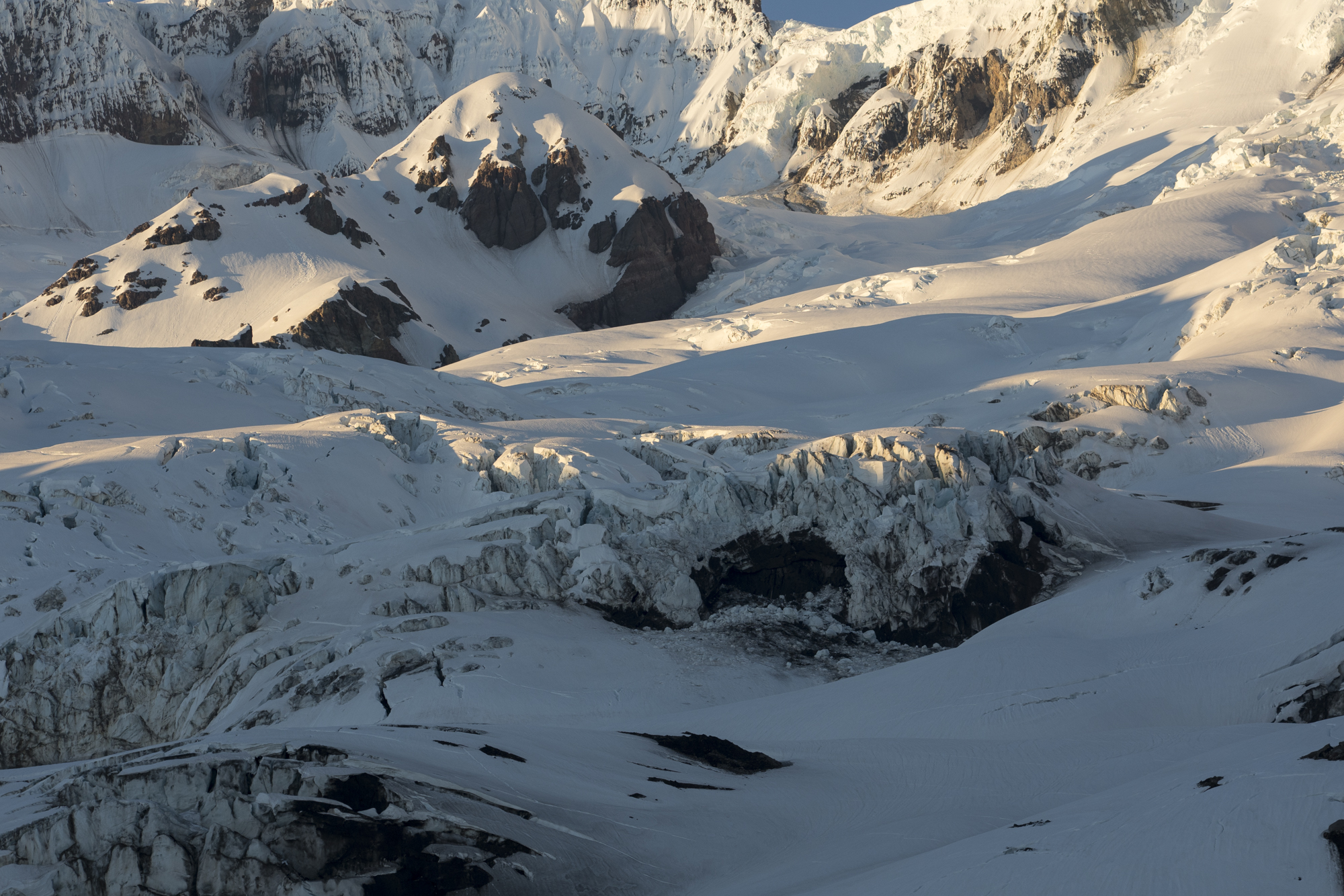
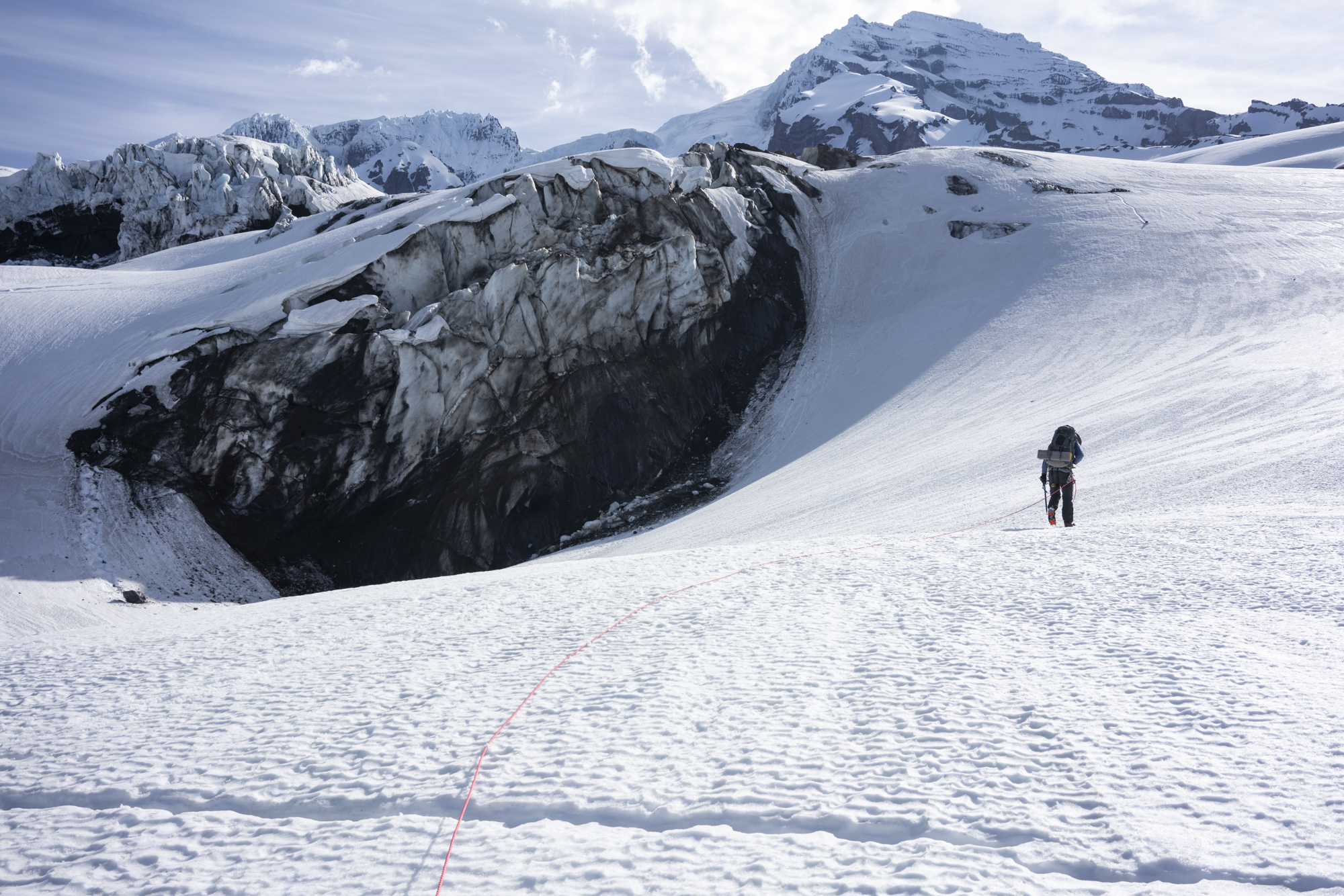
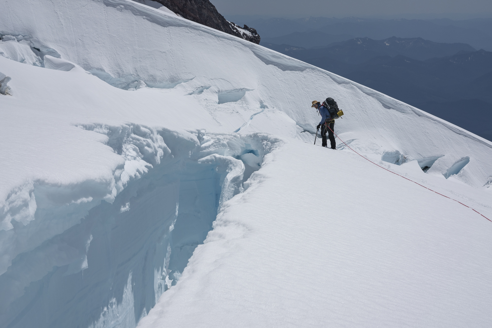
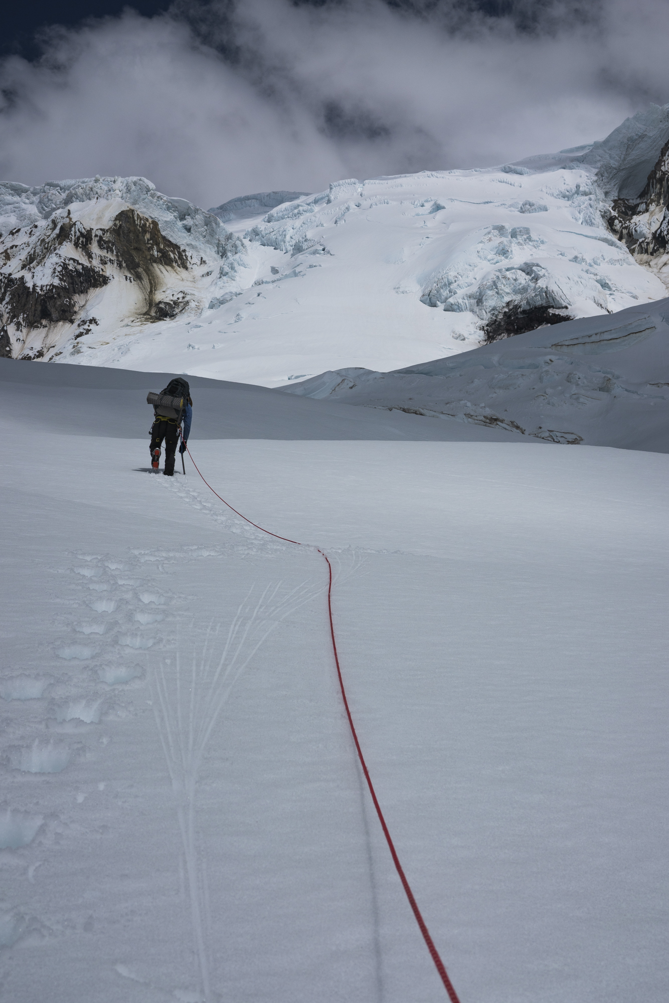
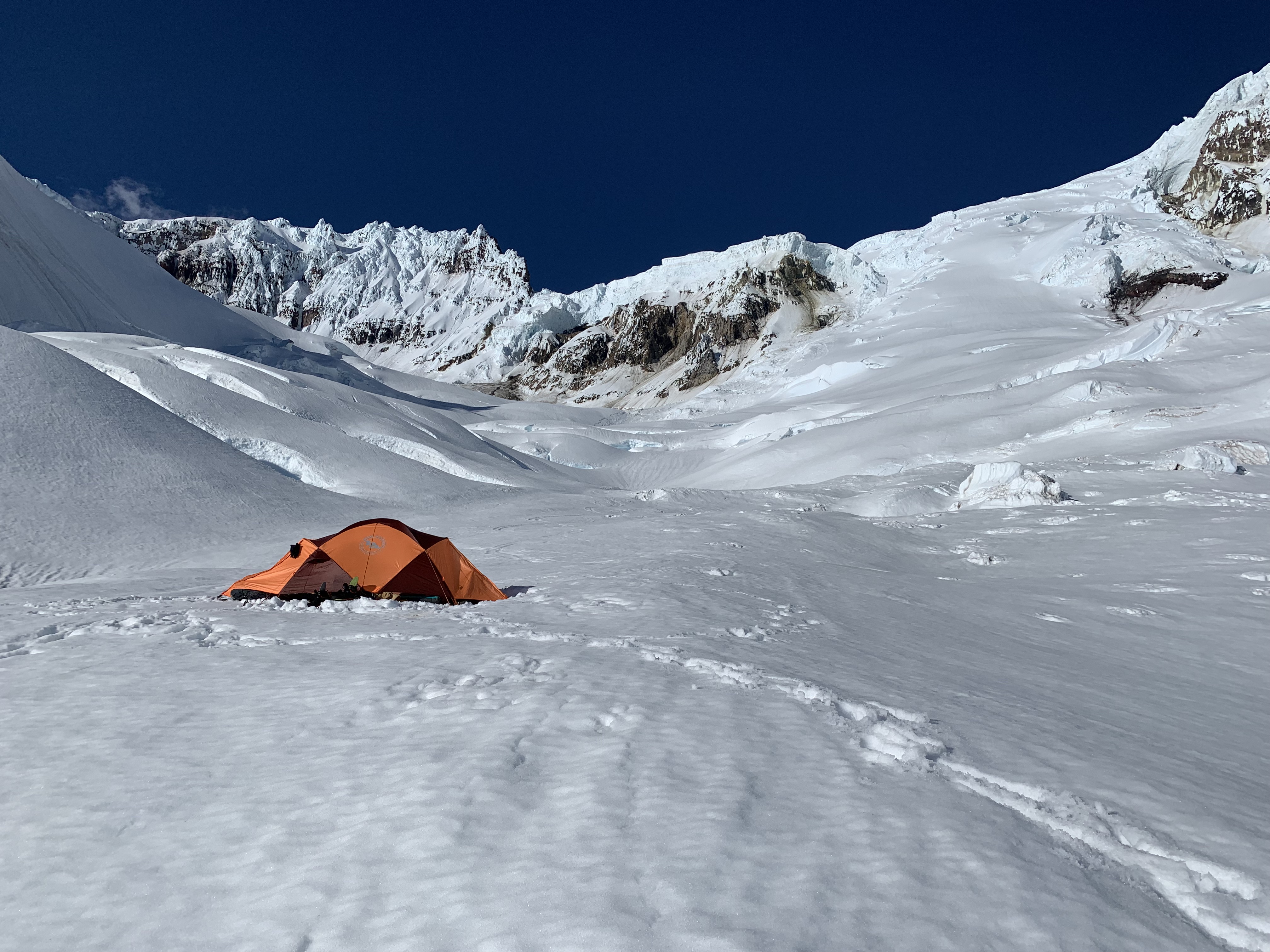
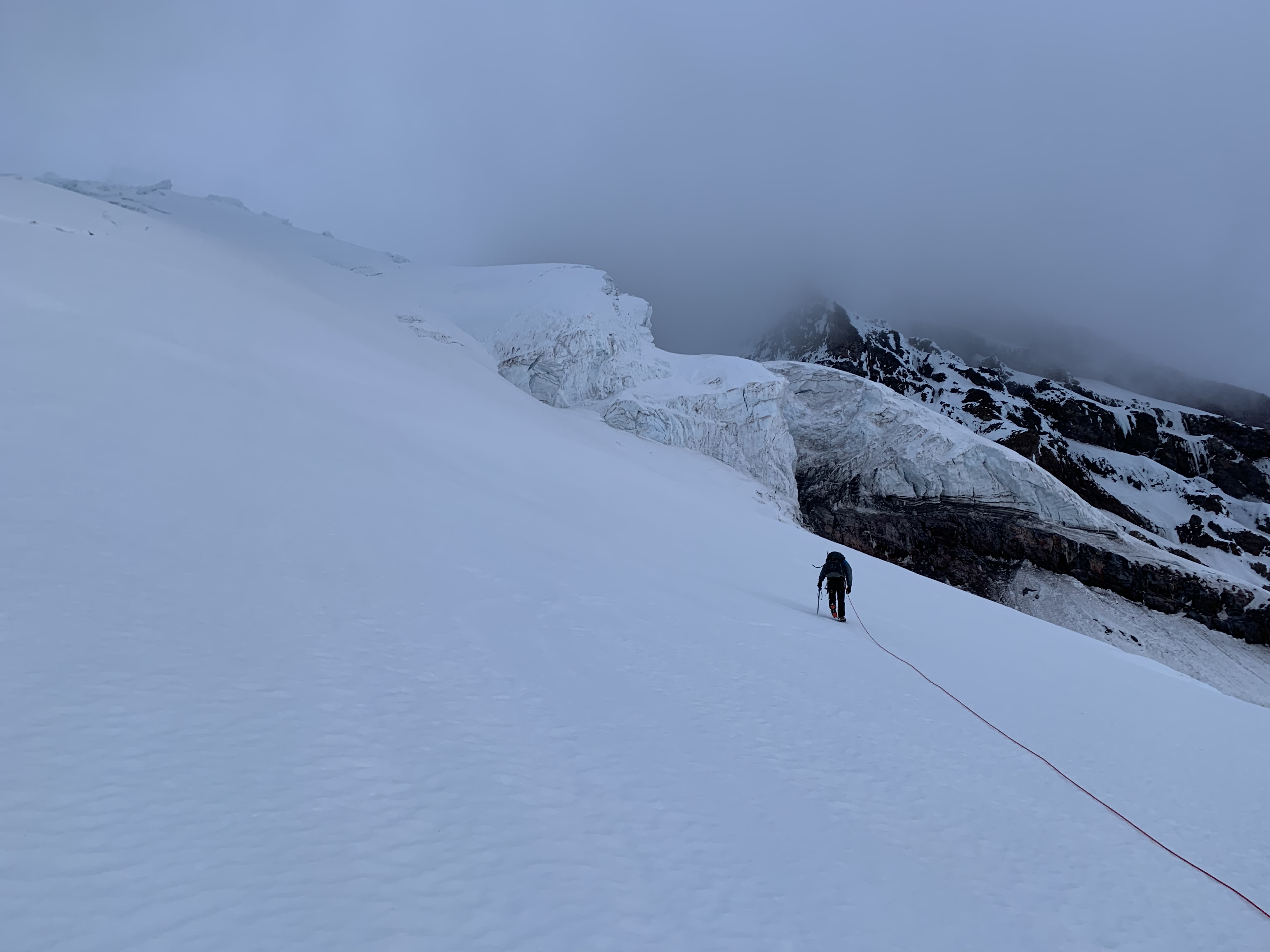
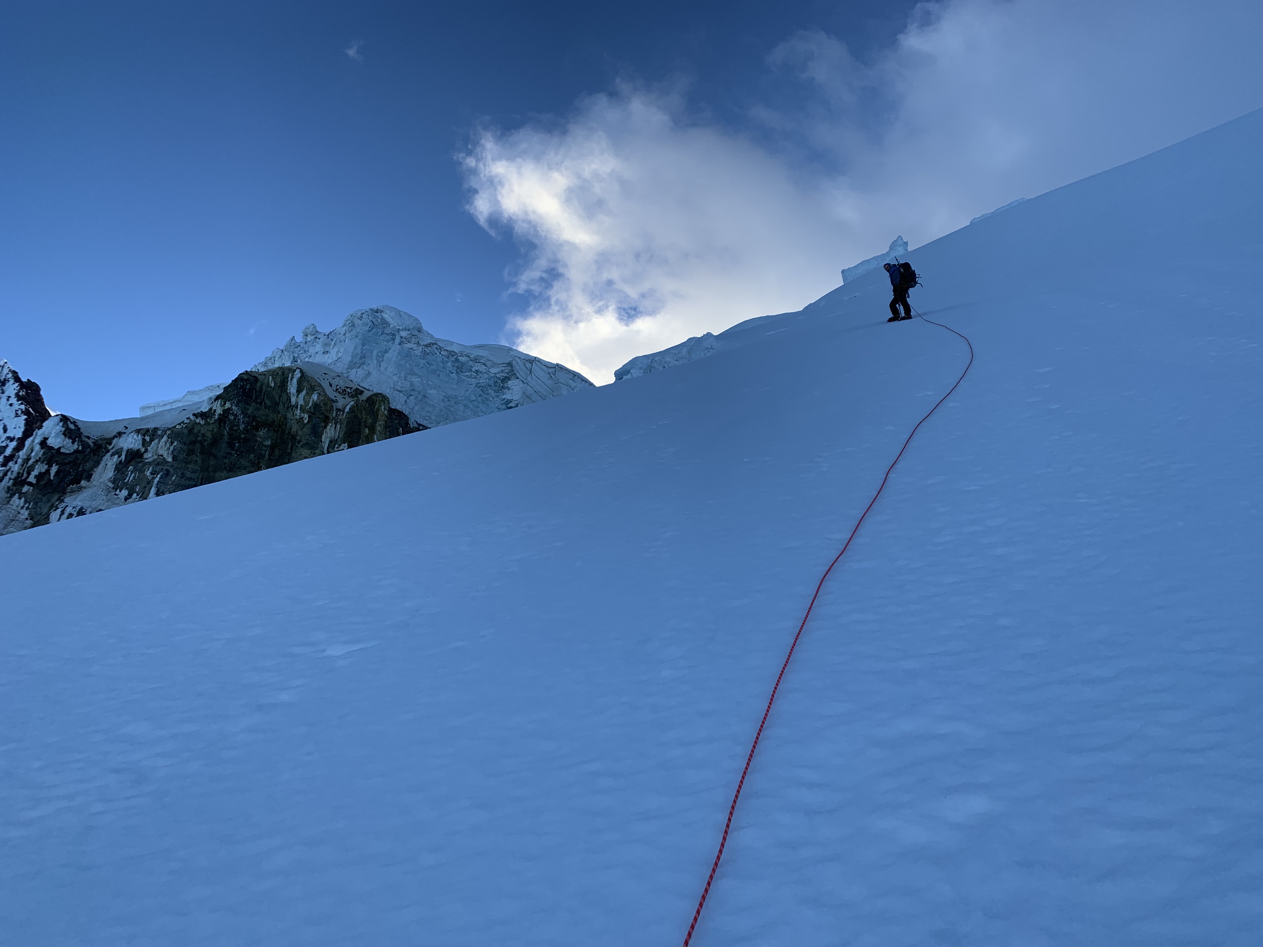
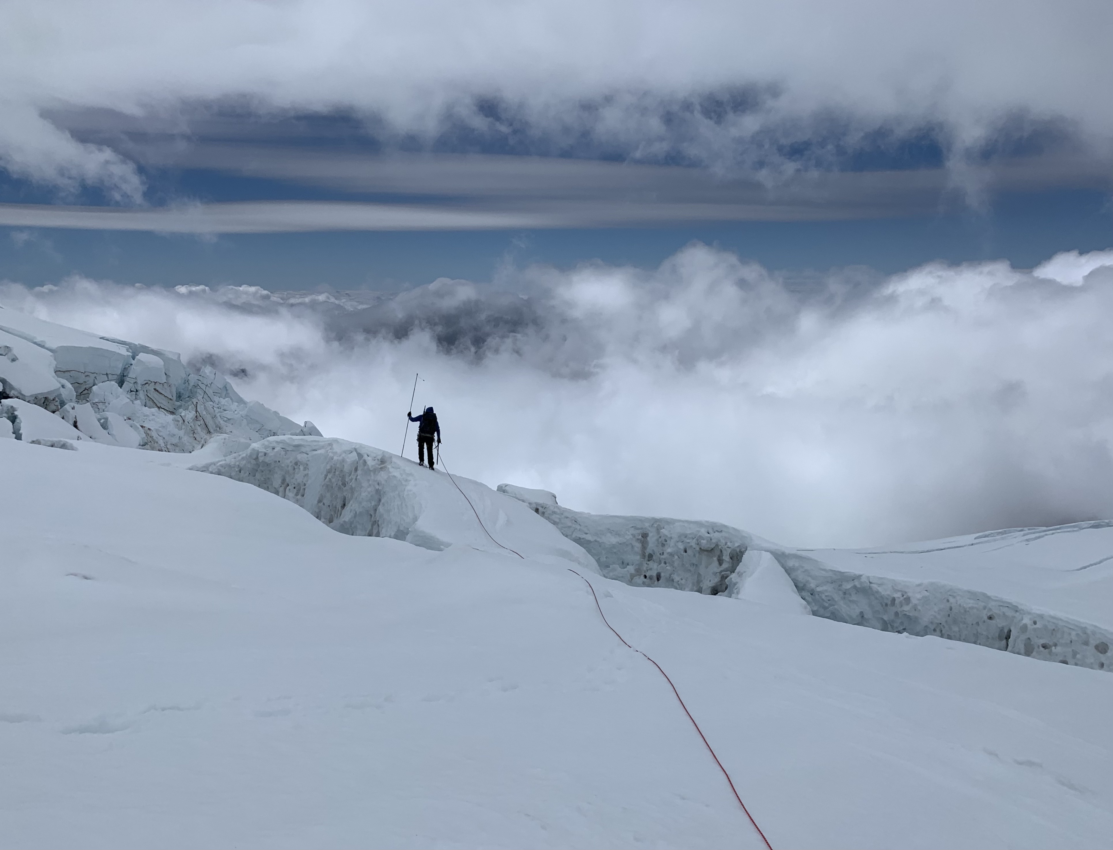
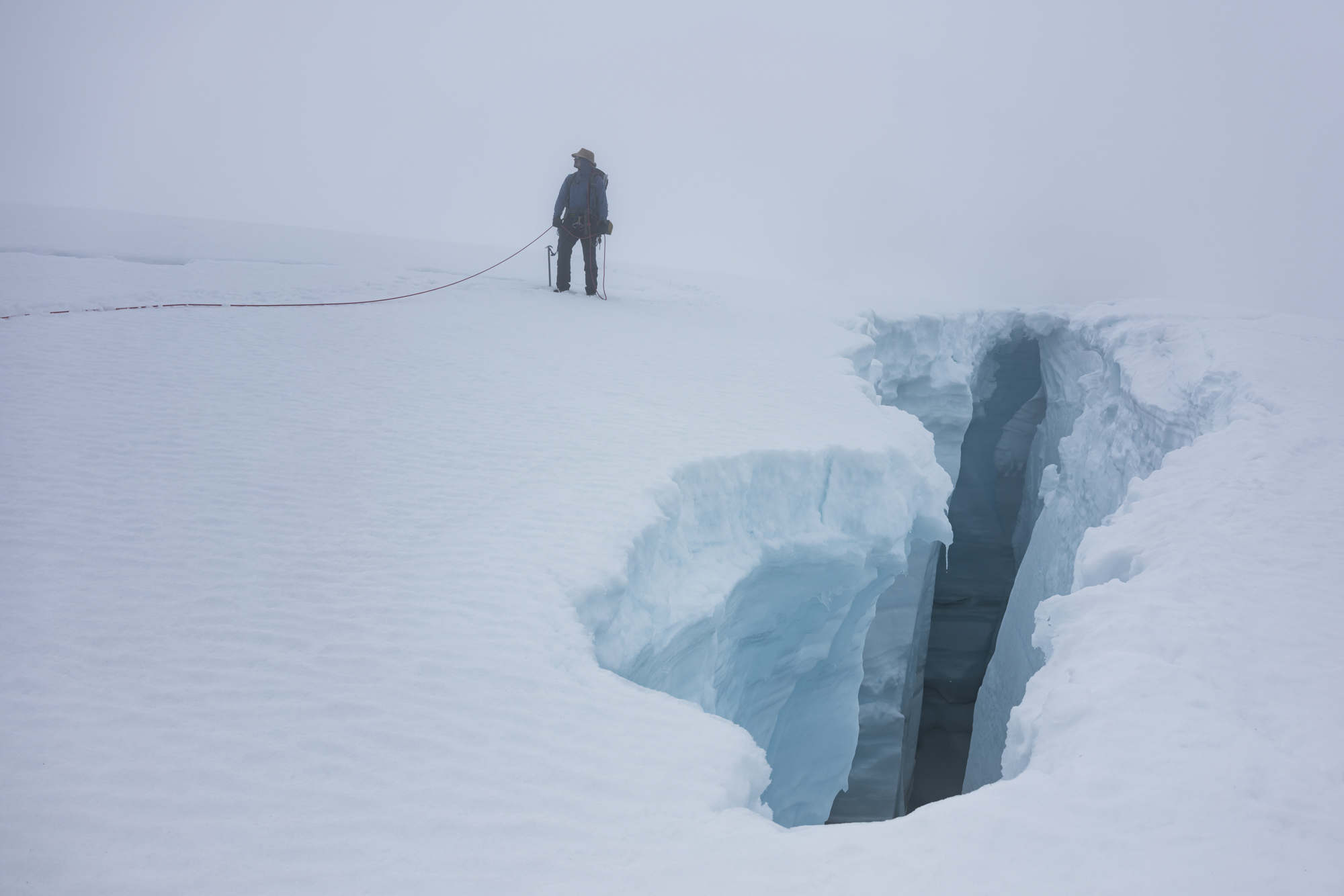
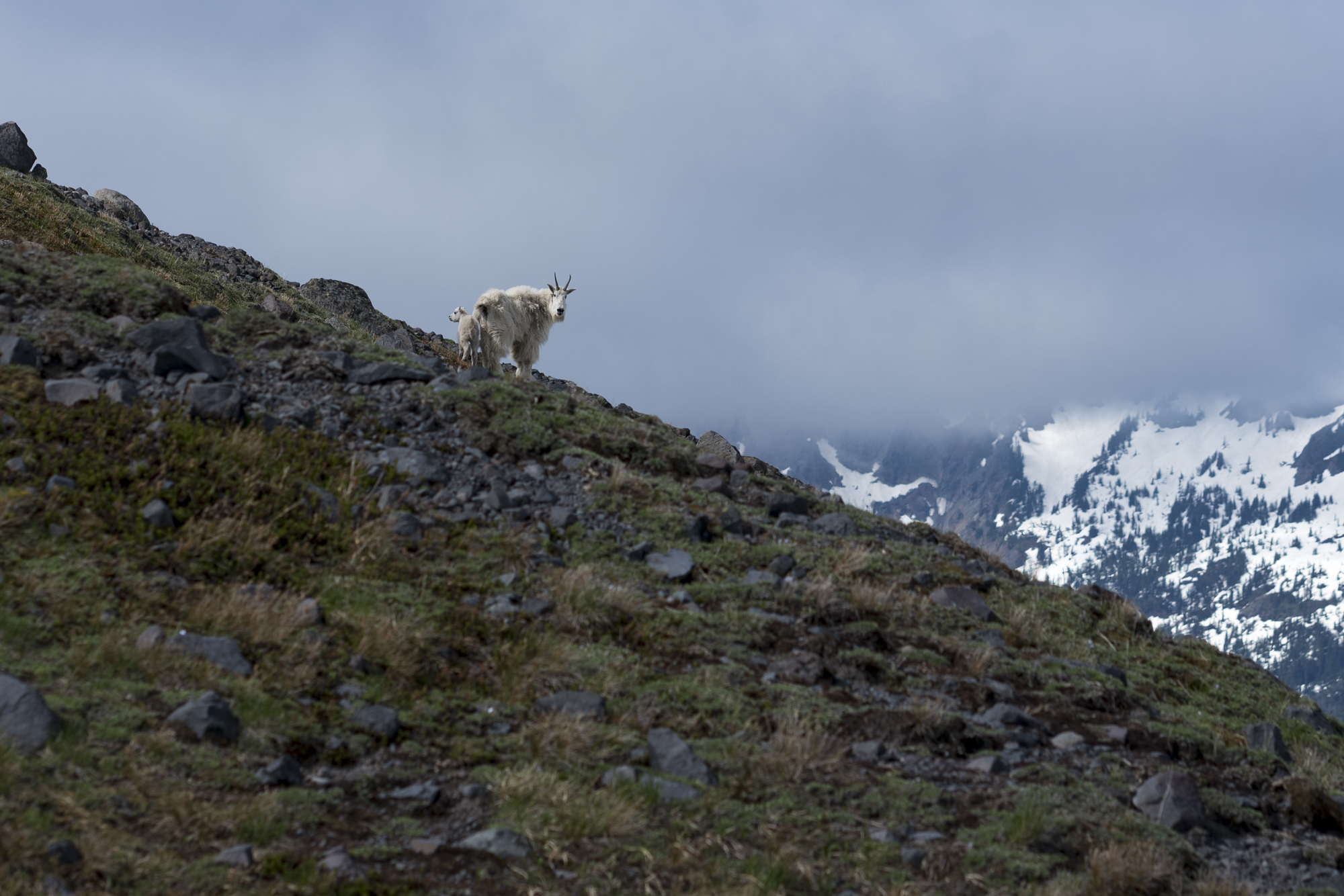
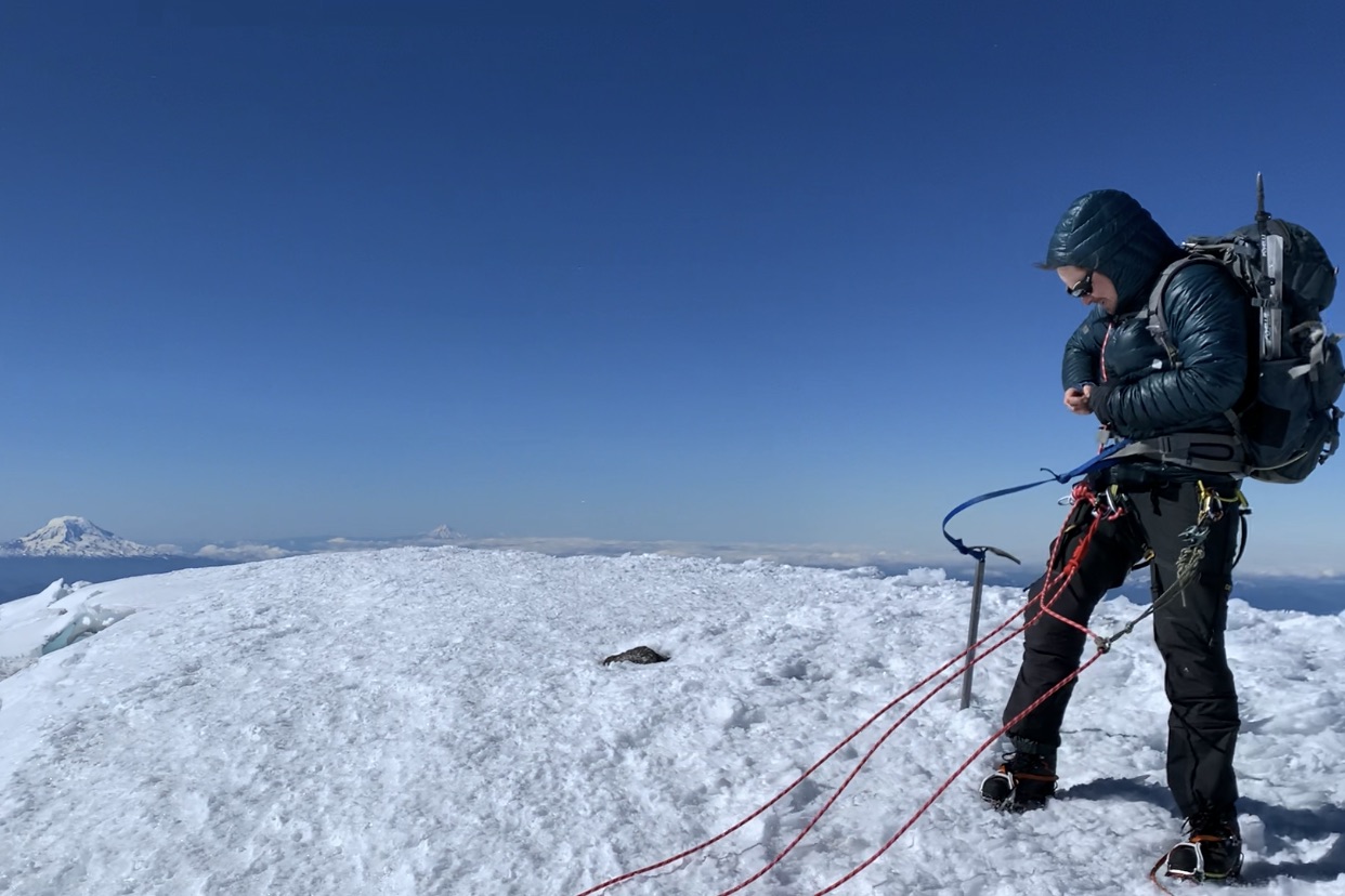
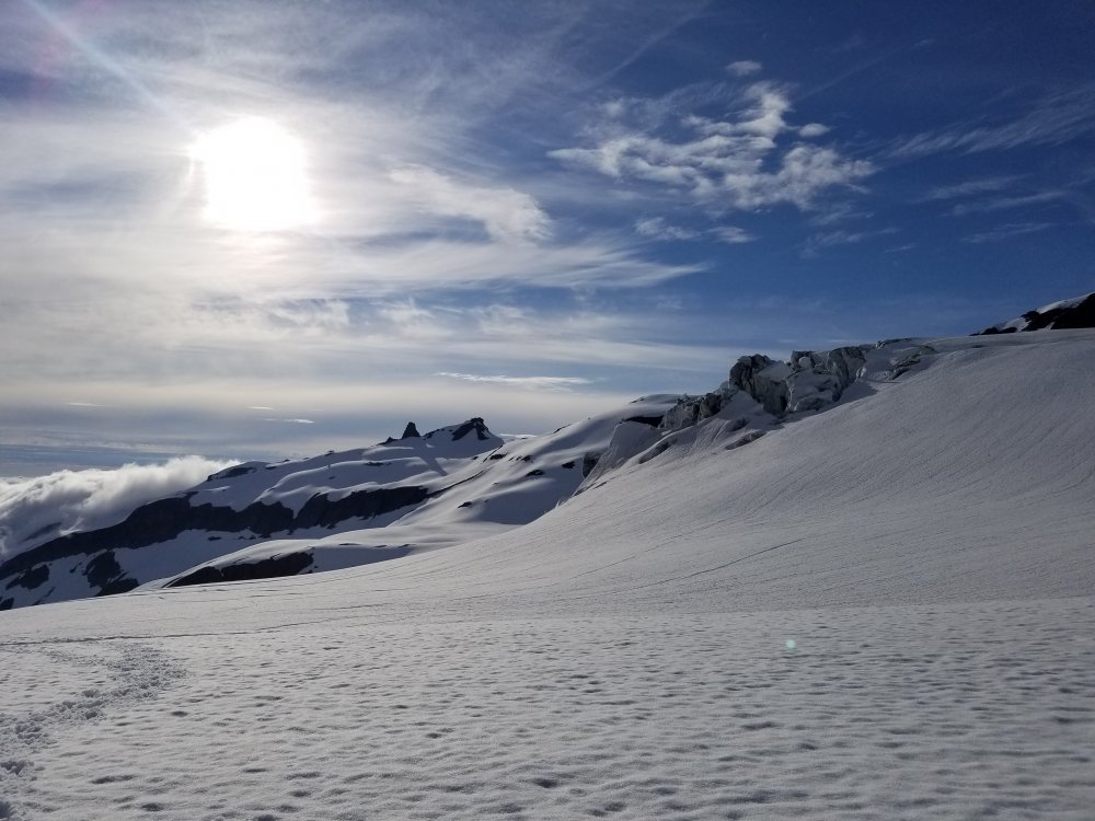
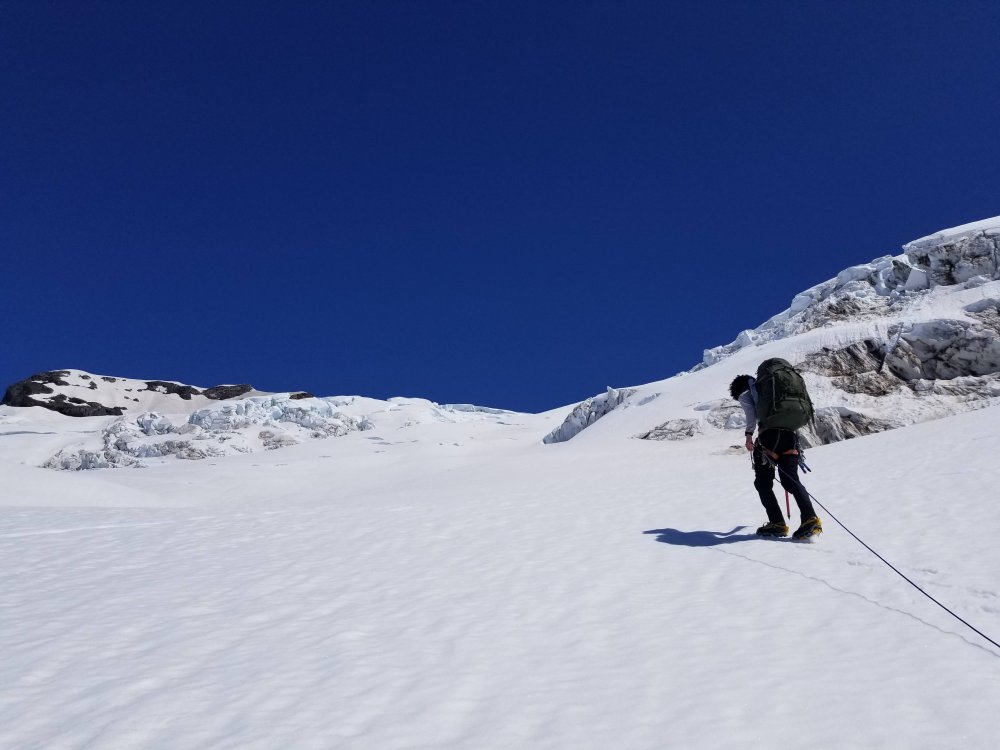
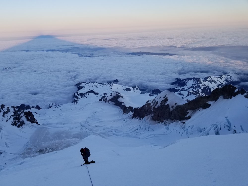
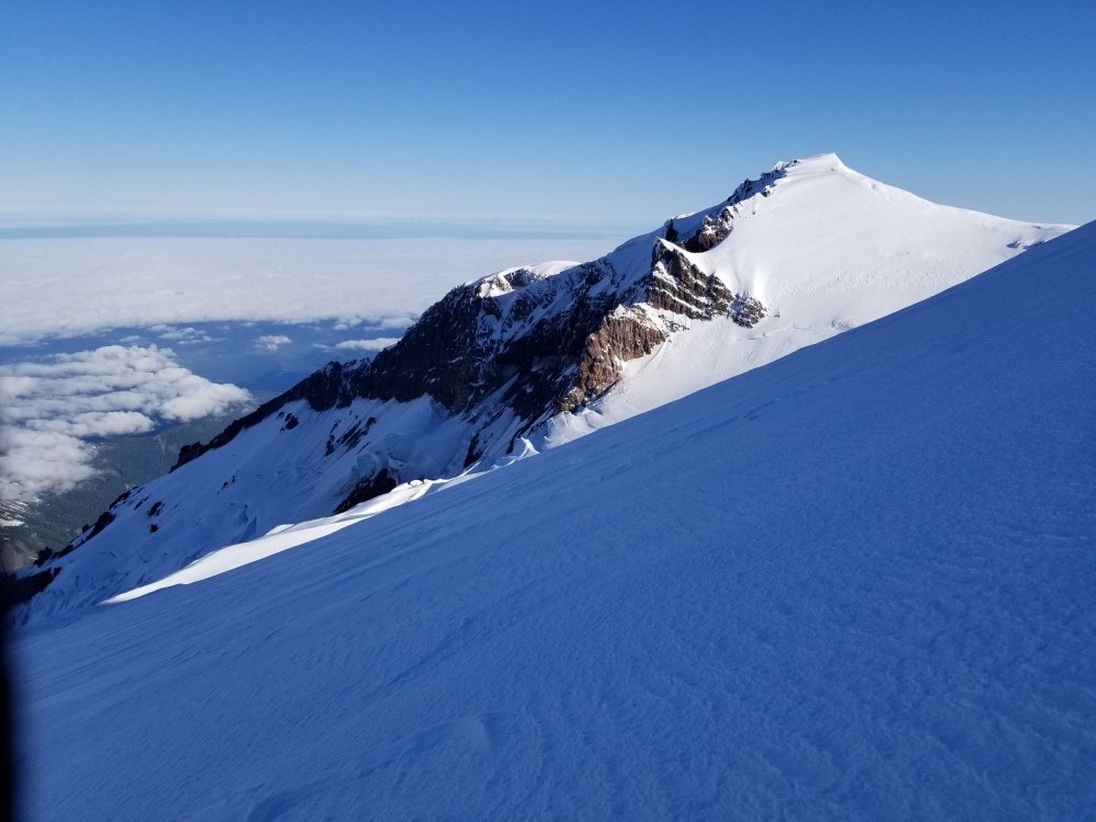
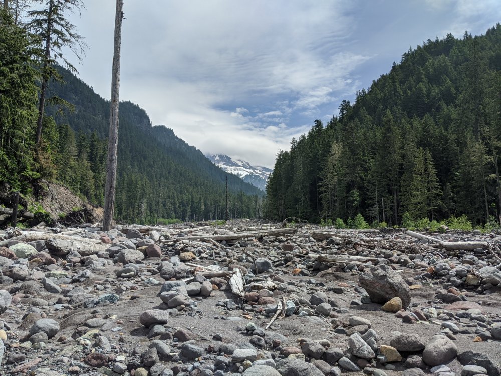
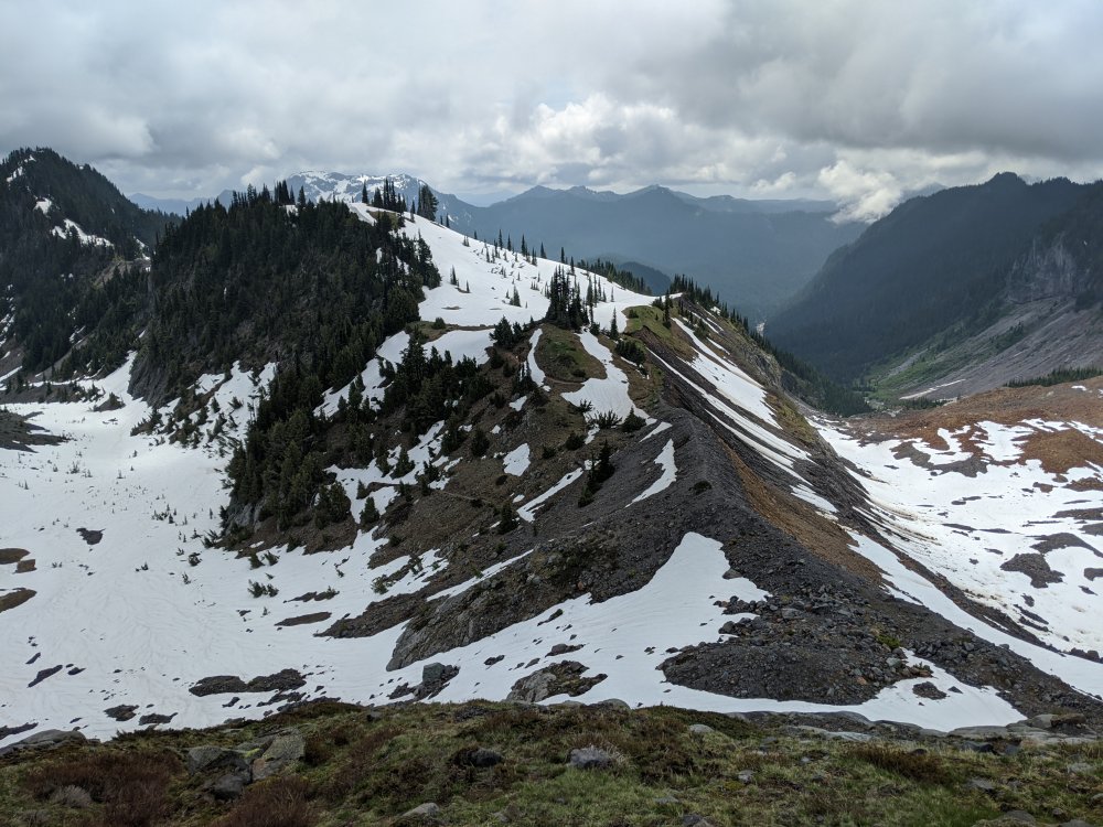
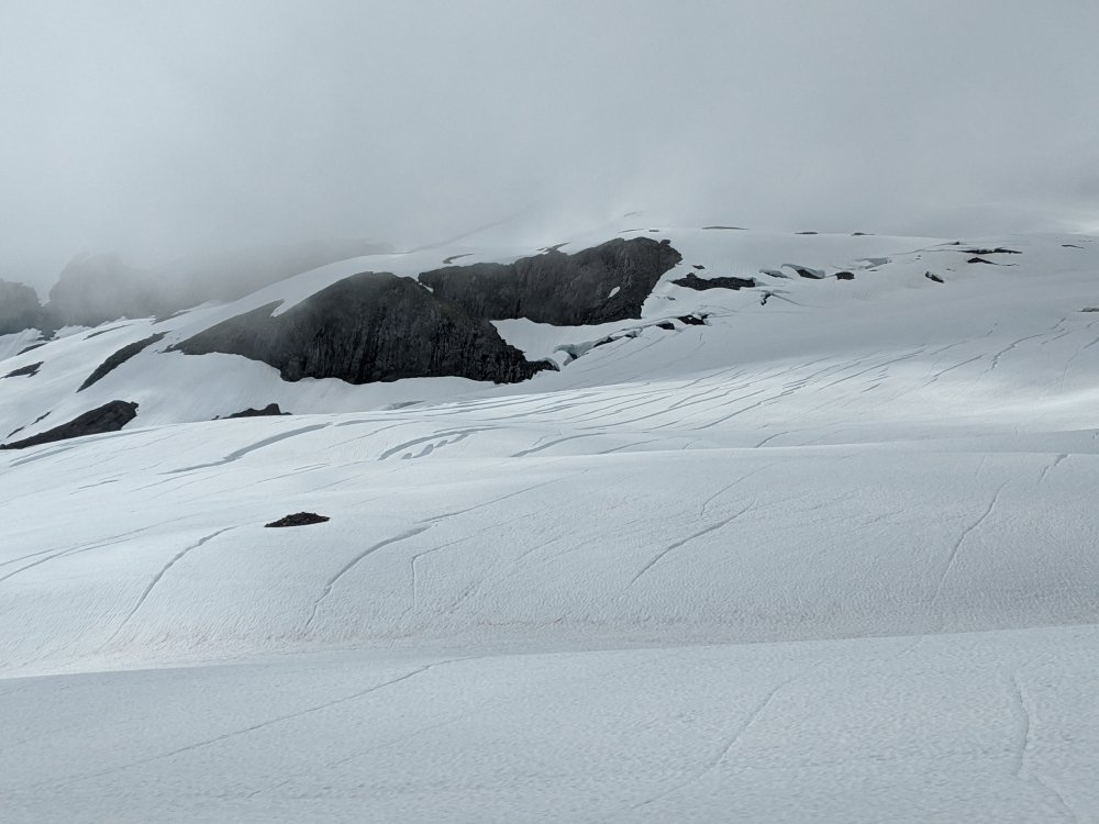
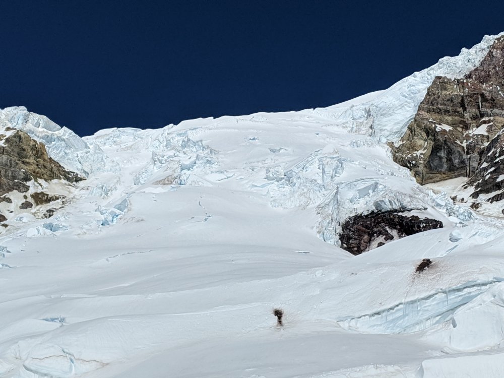
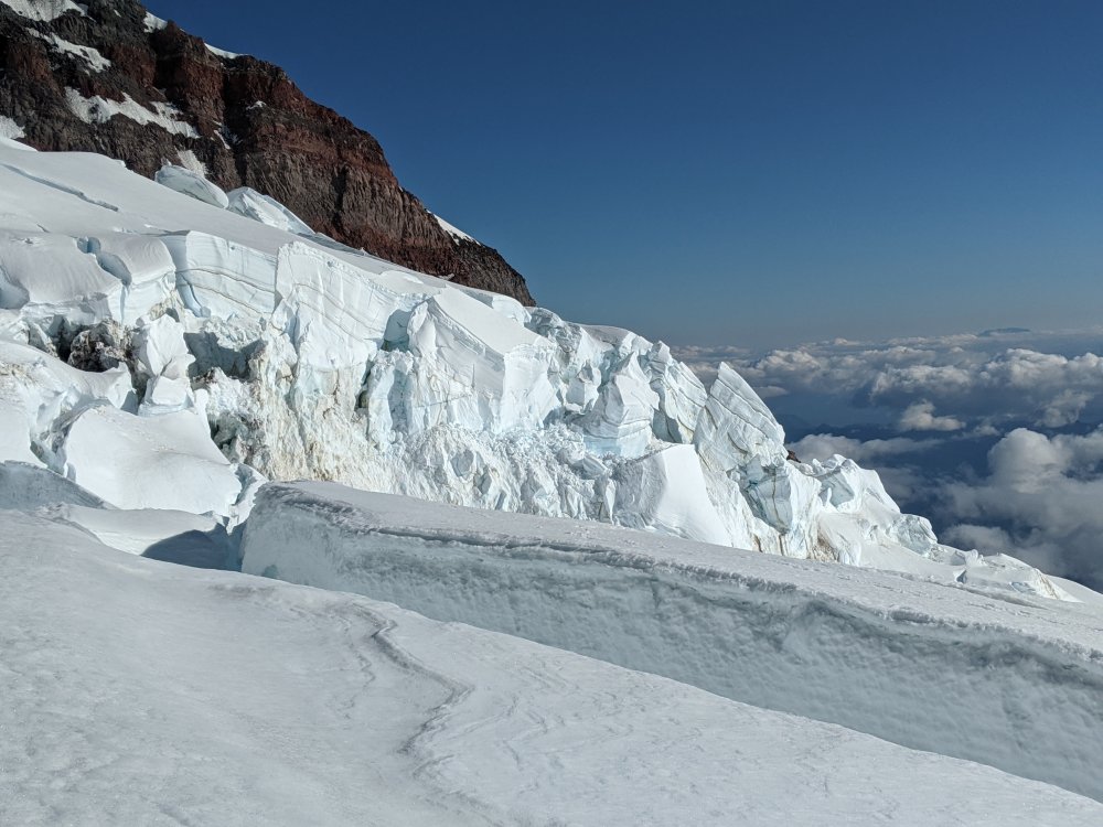
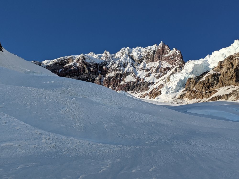
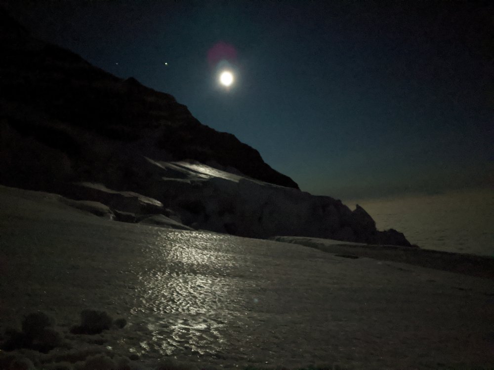
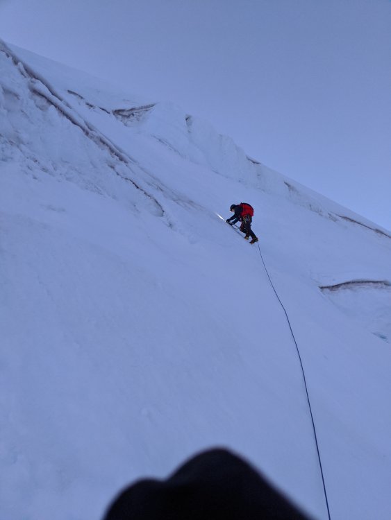
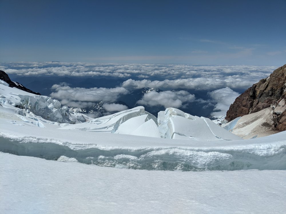
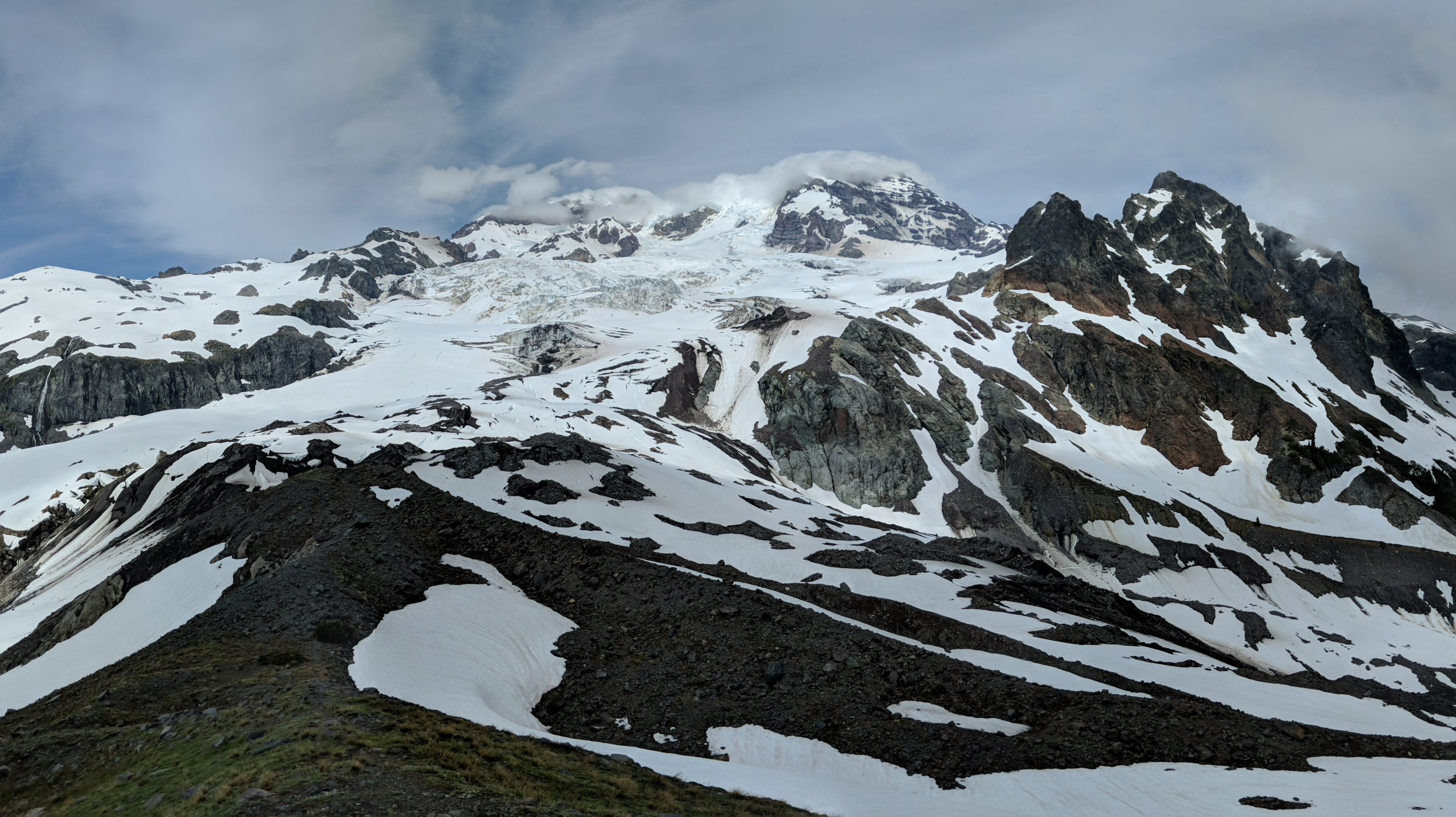
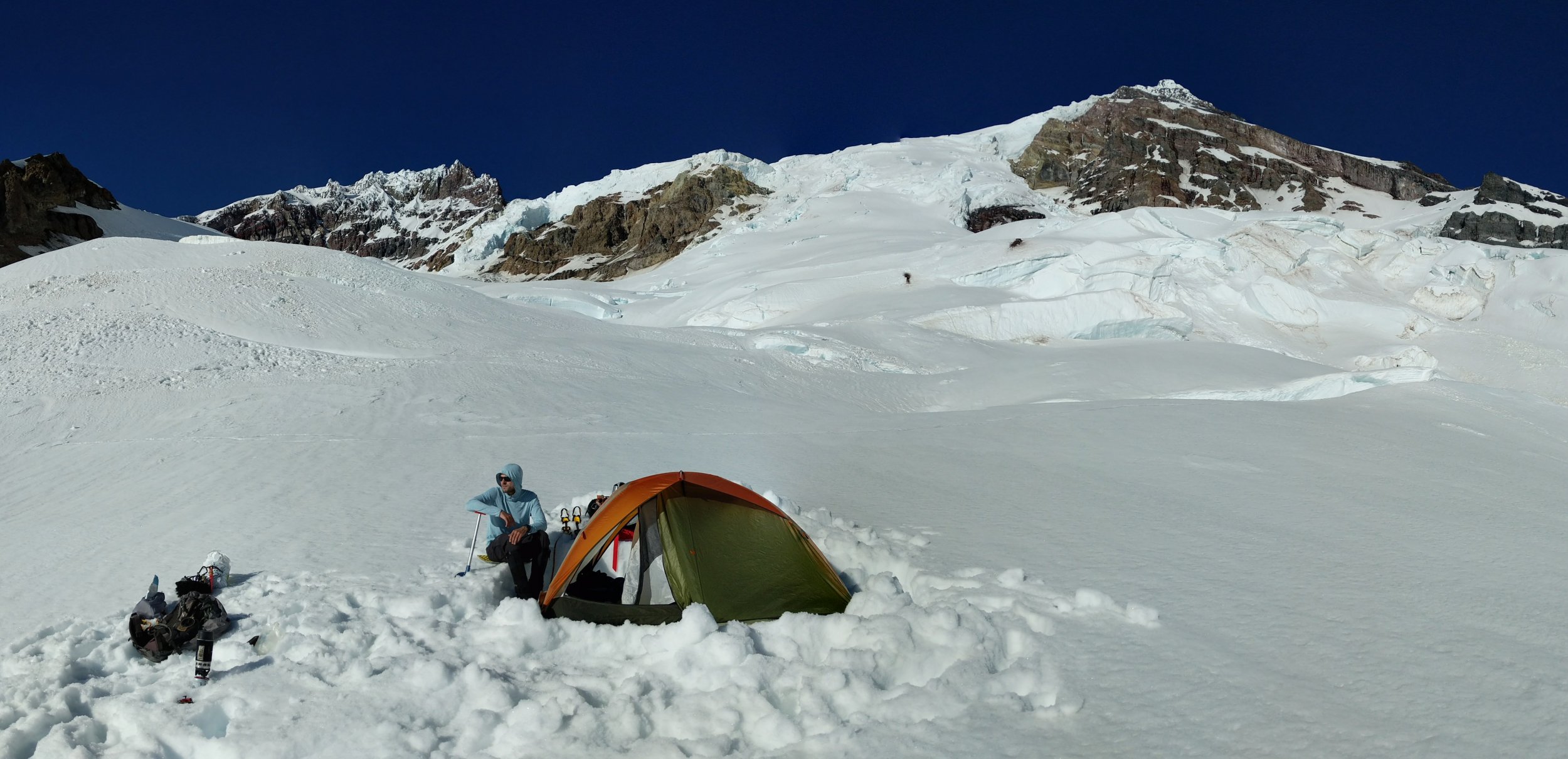
Trip: Tahoma / Mt. Rainier - Tahoma Glacier Trip Date: 06/26/2022 Trip Report: A constant search for adventure, solitude, and punishing elevation gains led Tom and I to attempt Mt. Rainier’s Tahoma Glacier from June 26-29. Spring conditions in late June beckoned with the possibility of easier route finding on what we’d heard was a notoriously broken glacier. Our hope was to ascend straight up the Tahoma Glacier from Emerald Ridge, avoiding the detour to the Puyallup Glacier if possible. This turned out to be entirely possible with current conditions on the Tahoma. Day 1 After grabbing a permit at Longmire on Sunday morning, we departed the Westside Road parking lot around 10:30AM. We soon turned off onto the Tahoma Creek Trail and subsequently lost it shortly after it crossed onto the creek bed. Though ascending the creek all the way to the Wonderland Trail wasn’t terrible (actually quite beautiful), after descending the actual trail on our way back, I very much recommend trying to keep to the trail. Not only is Tahoma Creek Trail gorgeous, it’s easier going than the rocky creek bed. Keep your eyes peeled for spots the trail re-enters the woods along the left creek bank, though they are admittedly quite well-hidden. It took us about 5 hours in total to ascend to Emerald Ridge from the parking lot, with the last half mile or so covered in rapidly melting snow. The lower Tahoma looked navigable so we decided to head straight up the glacier from there rather than continue around to Tokaloo Spire and the Puyallup. We took a moraine to the hill at the very end of Emerald Ridge and found a perfect tent site for our low camp at 6000 feet (5.5 miles from parking lot). There was even a trickle of running water to avoid melting snow. Emerald Ridge Campsite Adams from Emerald Ridge Looking towards St. Andrew's Rock Day 2 We were off the next morning around 8AM with the goal of establishing a high camp near St. Andrew’s Rock. We began the ascent on climber’s right up a ramp and around a few broken bulges before eventually cutting leftwards towards the center of the glacier for the rest of the ascent to high camp. Overall, we found the Tahoma Glacier entirely navigable, with only a handful of snow bridges warranting probing. Anywhere that we chose to cross a bridge there seemed to be alternate ways around or over the crevasse, so we were never left feeling stuck or cornered. At around 10,400 feet we found a flat shelf on the glacier to dig out a tent platform that seemed clear enough of icefall hazards from the two massive séracs on either side of the Upper Tahoma route. It was 3:30PM (7.5 hours and roughly 2.5-3 miles from low camp). We relished some much needed shade in our tent and listened to the calming sounds of ice and rockfall from the towering walls on three sides. The Upper Tahoma looked in superb condition with multiple possible paths to the summit cap so we decided to avoid the Sickle. The forecast called for dropping temperatures and a chance of showers the following afternoon, so we decided to be up and moving early to avoid freezing in whiteout conditions on the summit. High Camp at 10,400' Day 3 We were up at 2:15AM and made the decision to take down the tent and stash it with extra gear in a snow pit because the wind coming up the glacier overnight was relentless and seemed to be increasing. We were off at 3:45AM with the first hints of dawn appearing above Liberty Cap. Some fortuitous ski tracks from a bold ski descent of the Sickle the day prior (strong work from that duo) helped us find our way through the massive crevasses separating the route proper from the glacier basin. It was just above freezing and we found firm but good cramponing conditions on the bottom 2/3 of the route. As the sun rose, the snow steepened into a series of ice cliffs/shelves in the upper third of the route and we punched through the first line in a gully on the left that is bisected by a crevasse that will eventually make that path unnavigable (another gap a few hundred feet right of this one also looked reasonable). We then crossed rightwards up a steep slope and then crisscrossed left and right across the face 2-3 times seeking alternating ramps through the steeper ice shelves. We never felt the need for a picket or ice screw and never required a second ax. The wind was out of the southwest and getting stronger as the morning went on. By 8AM we had climbed through the last of the shelves and found ourselves on the thankfully relenting steepness of the summit cap in temperatures that were well below freezing. We hit the West Rim just after 9AM and reached the empty summit at 9:15AM in winds too strong to stand upright in. Unable to even shout our congratulations to each other in the wind, we snapped a few hasty summit photos and promptly retraced our steps across the ice cap to the Upper Tahoma. Summit! We downclimbed through the shelves and finally made our way back to high camp by 2PM (5.5 hours up, 4.5 hours down). The snow was softer on descent as direct sun begins to hit the route at 9AM this time of year. We packed up our high camp and proceeded down glacier to low camp around 3PM. After a 3-hour slog through slush and intermittent zero-visibility fog (which would have required a GPS track if our footsteps from the day prior weren’t still visible), we arrived back at our low camp on Emerald Ridge around 6:15PM, 14.5 hours after departing for the summit. Day 4 After 10 glorious hours of sleep, a very relaxed breakfast, and a brief visit from a mountain goat (who seemed moderately disappointed that we were occupying her ridge line) and her baby (who seemed completely oblivious to our presence and instead very preoccupied with jumping around), we began the trek down the Wonderland Trail towards the car at 11:45AM the next day. We found the upper end of the Tahoma Creek Trail and marveled at what we had missed by taking the creek bed on the ascent. Tahoma Creek Trail During our descent of Tahoma Creek Trail we had the good fortune of crossing paths with Pope and Dwayner, two apparently (formerly) prolific CascadeClimbers contributors. Such a joy to chat about routes and a bit of Rainier lore and history with you two, thanks for imparting some wisdom onto us relative Rainier rookies. Overall, in its current condition, the Tahoma offers spectacular isolation on a completely different aspect of the mountain, lengthy glacier travel, and a moderate final climb to the summit cap. Gear Notes: Probe was necessary. Didn't require pickets or screws in current conditions. Approach Notes: Try to stay on the Tahoma Creek Trail if you use it for approach.
 1 point
 -
Trip: Whitehorse Mountain - Northwest Shoulder Trip Date: 06/25/2022 Trip Report: Four of us climbed this standard route on a sunny day in late June. After many years of passing by the mountain on the way to Darrington slabs, wondering when I'd get on it, it was a relief to stand on the summit. Mark and I started the hike at 6:30am, Kellie and Russ a little later, and returned to the cars at midnight. The snow was firm enough for good footing, and the moat was unexpectedly easy to cross. Our 30m rope was just enough to cover the summit rock climb. My thanks go to Mark, Kellie, and Russ for their competence and conviviality. Traversing to the High Pass The short rappel into the moat The spacious confines of the moat Looking back down the glacier to High Pass Out on the planet Gear Notes: Two 30m ropes, a medium nut and a green Camalot Approach Notes: Straight forward, nothing much to add.1 point
-
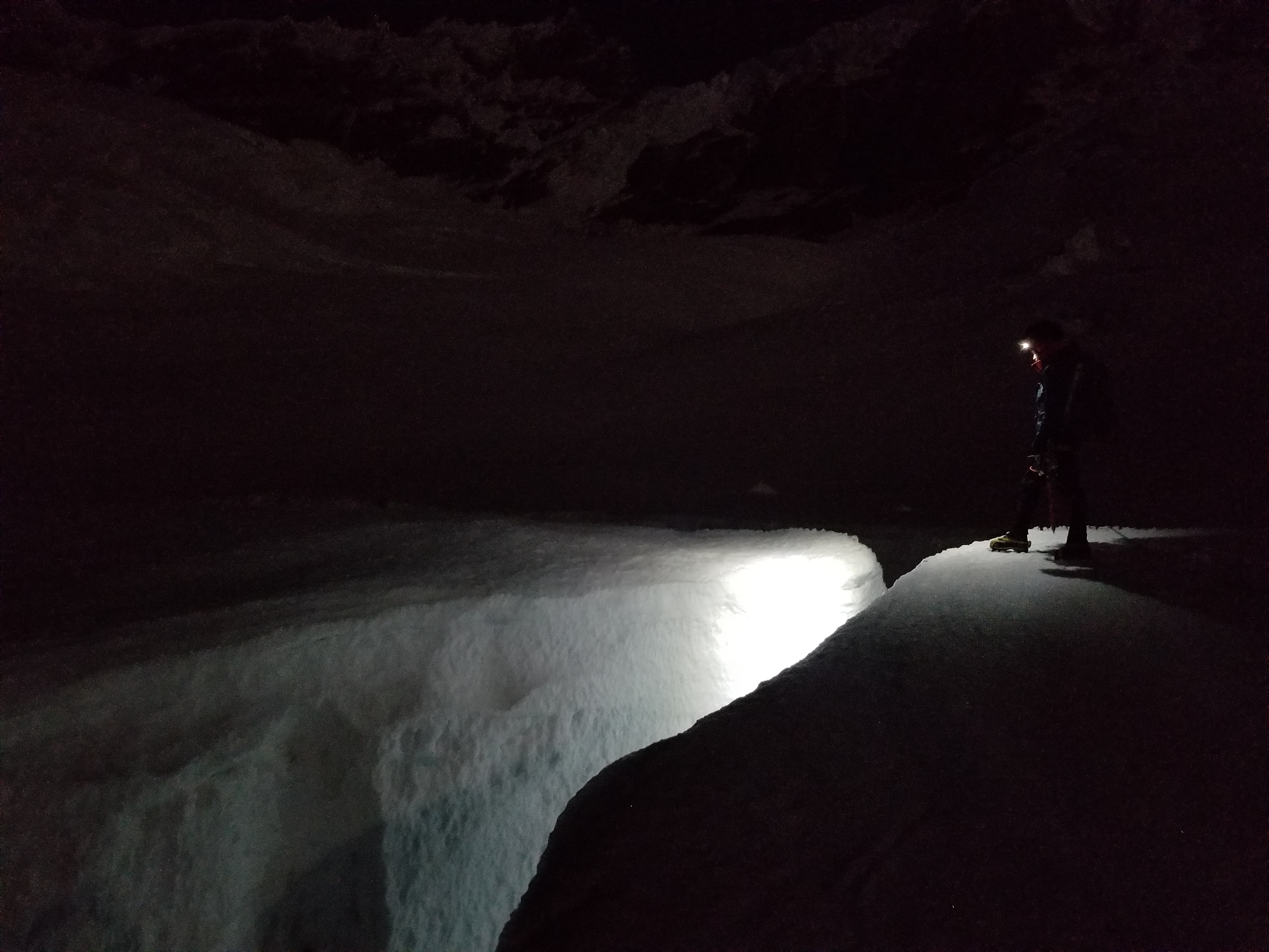
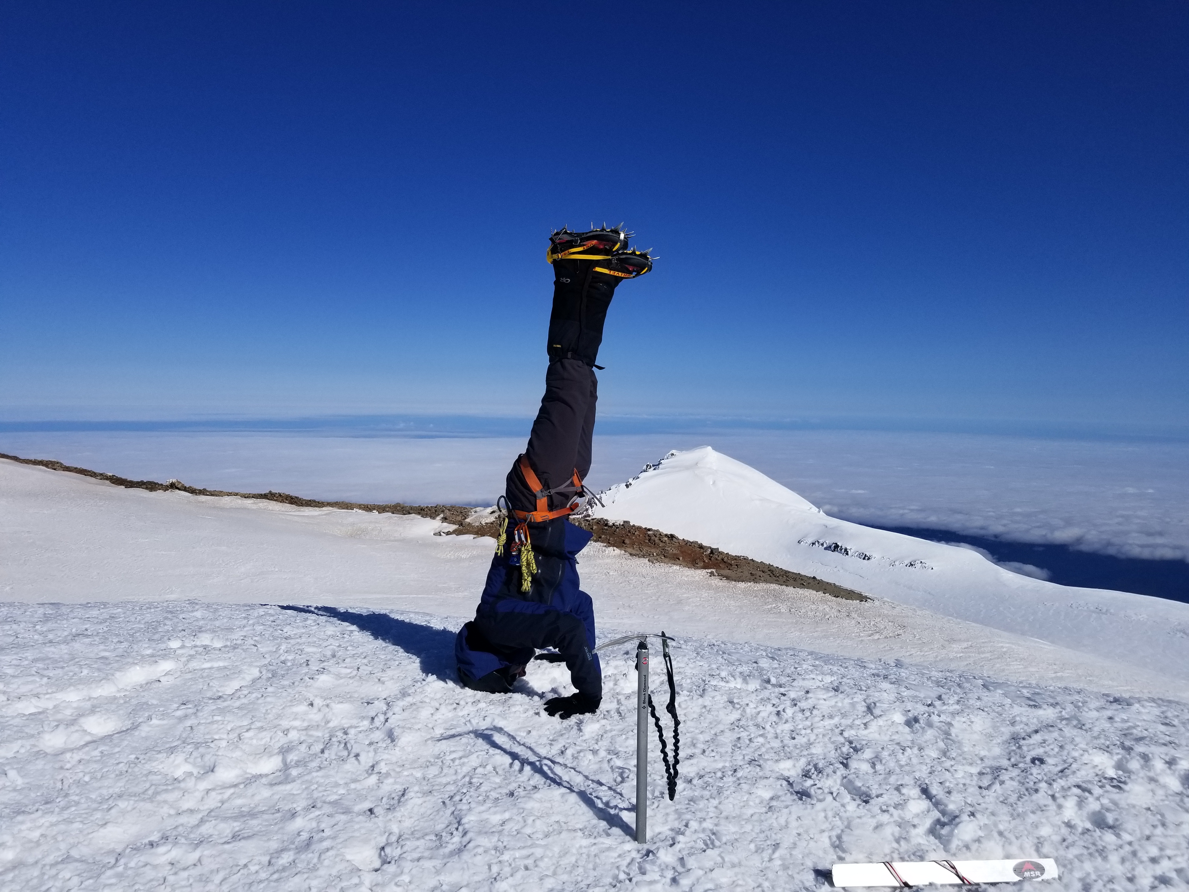
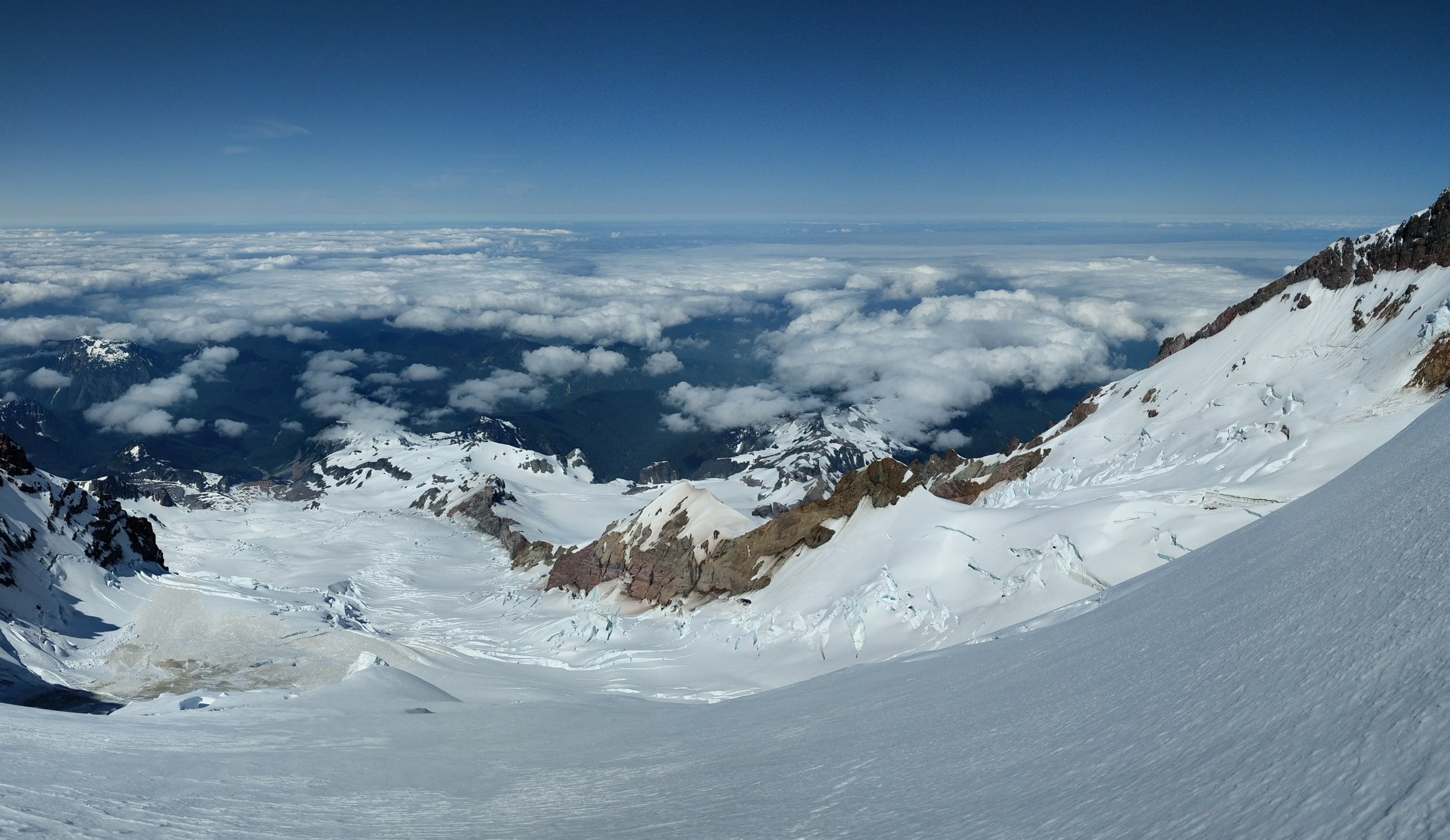
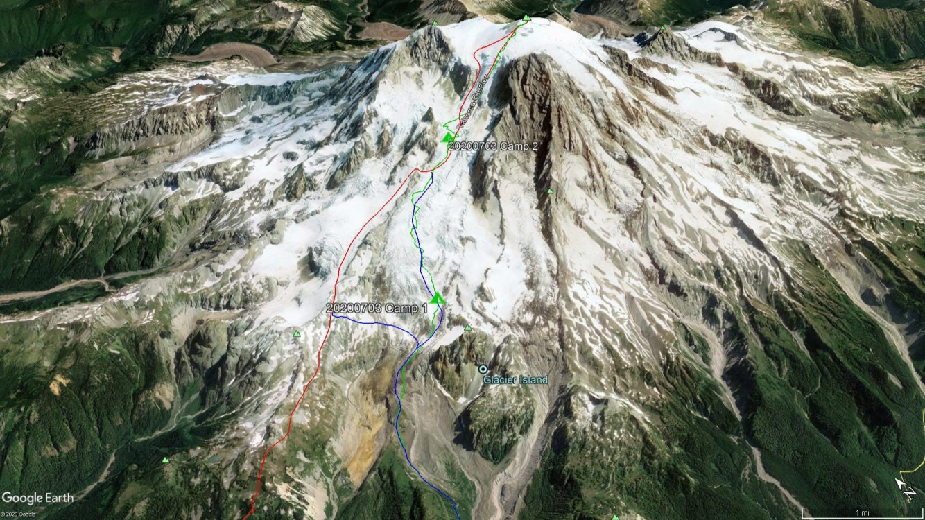
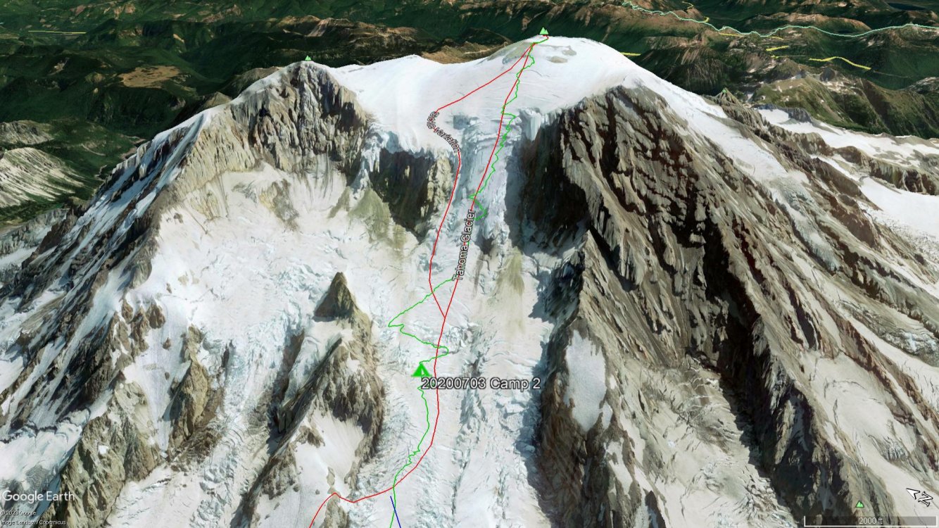
Trip: Mt. Rainier - Tahoma Glacier Trip Date: 07/03/2020 Trip Report: The Tahoma Glacier piqued my interest the last couple seasons as I explored new routes for my next Mt. Rainier climb. The low starting elevation, long approach, and remoteness of the route was especially appealing to me. Covering that distance and elevation on a route that receives very little traffic would be a fun challenge and great test of mountaineering skills. I was also excited to experience the mountain up close from a different perspective since I had only been on the west side of the mountain once before during a Wonderland Trail hike. However, with the park shutdown due to COVID-19 we were uncertain if we would get a shot at the Tahoma Glacier before it was too late in the season. We planned the climb for the weekend of June 19th and were excited when MRNP announced they would reopen that very weekend. Unfortunately, as the date approached the weather was not looking too promising. Reluctantly, we postponed the climb to the 4th of July weekend when we both had time off work. This time the weather forecast was looking stellar: clear, light winds, and cold (~11000' freezing level). And we would have a full moon. Game on! Our plan, which we later learned would be a bit ambitious, was to reach high camp (~9600') on day 1 (Friday), summit Saturday morning, and either exit the same day or stay one more night and hike out Sunday morning. For the approach, we decided on the more direct Emerald Ridge/Tahoma Glacier approach over the St. Andrews Park/Puyallup Cleaver approach. We knew we were getting into the tail end of the season for the route, but with our good snowpack this year we were optimistic that we could navigate the lower Tahoma without too much trouble. Also, there seemed to be an option to bail to the Puyallup Cleaver shortly after gaining the Tahoma Glacier if we found the glacier to be too broken up. The two of us set off from the West Side Road parking lot (2850') at 10:30a with cool temps and a partly cloudy sky. After a short hike on the road we arrived at the beginning of the Tahoma Creek Trail, marked by a drum for disposing of blue bags and a "trail closed" sign not far off the road. The Tahoma Creek Trail follows the Tahoma Creek until it joins with the Wonderland Trail at the impressive suspension bridge across the creek at 4200'. From there, you continue on the Wonderland Trail to the top of Emerald Ridge where you can gain the lower Tahoma Glacier. We followed the Tahoma Creek trail and other tracks the best we could, but with parts of the trail washed out we eventually lost it and ended up hiking along the edge of the floodplain. We kept our eyes peeled and in time we saw some cairns and orange marking tape at around 3500' which led us back to the proper trail. From then on, the trail remained intact and joined up with the Wonderland Trail where we continued on to the top of Emerald Ridge, passing by the occasional Wonderlander. Consistent snow began around 5200' which is where we stashed our trail runners and booted up. Tahoma Creek Floodplain: We parted ways with the Wonderland Trail at 5600' and made the short scramble to the top of Emerald Ridge and the toe of the Tahoma Glacier (6000'). Here we took a break and donned our glacier gear while taking in the views of Glacier Island and the true size and length of the Tahoma Glacier. Getting onto the glacier was straightforward and the cracks were small and manageable all the way up to a flatter area of the glacier at 7200'. Top of Emerald Ridge, looking back at the Wonderland Trail: Toe of Tahoma Glacier, Glacier Island on the right: At 7200' we stopped to assess our progress. It was already 6:00p (7.5 hours from the car) and we still had a good amount of glacier to cover to get to high camp. We were also low on water so we would need to melt some snow to replenish our bottles before continuing. At our pace, it didn't seem feasible to reach high camp that night at a reasonable hour and be ready to summit the following morning. We discussed our options and ultimately decided to establish a low camp at 7200' for the night, move up to high camp the next day, and summit on Sunday morning instead. We were due back home Sunday night, so that would leave us with a long hike out after summiting Sunday morning, but this plan would give us the best chance for success and make the trip much more enjoyable. Luckily the weather for Sunday was supposed to be just as good as Saturday. We set up camp and called it a day. Lower Tahoma Glacier: View from Camp 1, looking toward Tokaloo Spire: Sunset from Camp 1: On Saturday we woke up to clear skies and a great view of the upper mountain that was covered in clouds the day before. We took our time getting going and scoped out a route up the lower glacier. It was definitely more crevassed than what we had already traveled and the best looking route was in the direction of the Puyallup Cleaver and the looker's left side of the glacier. We broke camp and set off around 10:30a. Morning view from Camp 1, looking toward the summit: On the way up to Camp 2: The crevasses we encountered on the way up to high camp were growing in size but were still easy to cross with a short hop or snow bridges. Nothing too sketchy even with the sun beating down and snow quickly softening up. Our route did meander a bit as we searched for the most efficient way up the glacier, so it did take longer than expected. We reached 9400' at 2:00pm where we thought about setting up camp. This is where we would have joined the Tahoma Glacier had we taken the St. Andrews Park/Puyallup Cleaver approach; however, the ramp to get off of the Puyallup Cleaver did not look to be in the best shape. There was likely a path off the ramp onto the glacier, but we were glad we chose the approach that we did. Ramp at 9600': After a long break we pushed on a bit further through ankle and shin deep slush up to 10400' where we found a good spot for a high camp. I had read about other parties camping at this location as well. It was 4:30p at this point, 6 hours after leaving camp 1. From here we finally got a really good view of the upper glacier and the potential routes. Earlier in the day we saw that the looker's right side of the glacier may be a good option, but now we could see right up the center of the glacier and the Sickle variation. The Sickle looked to be in good shape with not a lot of evidence of icefall, but the seracs at the top of the route were intimidating. We decided against the Sickle and to attempt one of the other routes. We would make that decision in the morning under the full moon light once we gained some more elevation. We set up camp, ate, melted snow, and tried to get to sleep as the sun was setting. I fell asleep to the very faint sounds of 4th of July fireworks way off in the distance. Upper Tahoma Glacier: Camp 2: Sunset Amphitheater: Tahoma Glacier: The next morning we set off at 2:00a under a very bright full moon that lit up the mountain. It was right around freezing with no wind and the snow had firmed up nicely. We were excited to start the journey up the main route, but less than 30 minutes out of camp we thought the trip was over. We found ourselves on an island of ice with a pretty sporty jump to continue on. We contemplated it for a while but just didn't want to risk it, especially on the descent when the snow would soften up. Damn! That jump seemed like the only way, but we backtracked some and skirted around where we got stuck and luckily found a crossing! Phew! We wondered if this was going to be the theme of the entire ascent. We continued on and at this point chose to continue right up the center of the glacier rather than traversing over to the far right side option we saw. Full moon: Contemplating the jump.: The snow conditions were great and took crampons very well which made for very efficient stepping. We took the path of least resistance and just crossed our fingers it would go. There had to be at least half a dozen times when we thought our luck ran out, but a lone and thinning snow bridge (which probably wouldn't last another week) was there to let us continue on. Besides the first obstacle we encountered we didn't have to do much backtracking, but we did have to snake our way around the crevasses to find acceptable crossings. We each carried a traditional axe and had a few screws and two pickets between us. We contemplated bringing a tool, but from all the beta we could gather a tool wasn't really necessary on this route. Turns out that was the right call. We did encounter a couple short sections of solid ice compared to the rest of the route which was a nice sun crust. Front pointing and a low dagger axe took care of the ice sections, but we did protect them with a screw and picket while simul climbing. Short ice section: Soon we found ourselves at the top of the glacier where the slope begins to ease up at around 13000'. With the main part of the climb behind us it was just a slog up to the summit! We ascended directly up the west side onto the summit plateau and reached on Columbia Crest at 8:30a, 6.5 hours after leaving camp. Sunrise: Liberty Cap: Summit Crater: Summit Headstand! After getting some pictures on the summit and saying hello to a party of 4 that came up the Kautz, we dropped off the summit for a break and then took off back down the mountain at 9:15a. Being western facing, the Tahoma Glacier doesn't get sun right away in the morning which is good since we wanted to be down off the bulk of the upper glacier before it started to warm up. The descent went well and we followed our tracks down. We did downclimb one of the ice sections with some protection, but other than that we moved fairly quick down the glacier. We returned to camp at 12:15p, 3 hours after leaving the summit. Tahoma Glacier, Puyallup Cleaver, St. Andrews Rock: Tahoma Glacier: Tahoma Glacier: It would have been nice to take it easy and stay another night, but we still had a long road ahead to get back to the car that day. We made some water and packed up camp, then took off down the glacier at 2:00p following our tracks from the day before. The hike out was uneventful and we covered the 9 miles and 7500' back to the car in 5.5 hours, descending a total of 11500' for the day. Success! What a climb! We both felt really proud to do this route. It was a true test of our endurance and mountaineering skills, especially with navigating the very crevassed glacier. Oh, and we had the entire glacier to ourselves...we didn't see a single person between leaving the Wonderland Trail and the Summit. Being on our own without any tracks to follow made the trip even better. Day 1, Car to Camp 1, 6.7 miles, +4400', 7.0 hrs Day 2, Camp 1 to Camp 2, 2.5 miles, +3200', 6.0 hrs Day 3, Camp 2 to Summit, 2.8 miles, +4000', 6.5 hrs Day 3, Summit to Camp 2, 2.8 miles, -4000', 3.0 hrs Day 3, Camp 2 to Car, 9.0 miles, -7500', 5.5 hrs Total Mileage = 23.8 miles Total Elevation Gain/Loss = 11500' GPX track can be found here: https://caltopo.com/m/7M3P Gear Notes: Light glacier rack, a couple screws. Used screw and picket on icy section. No need for a 2nd tool. Approach Notes: Approached via Emerald Ridge/Tahoma Glacier.


 1 point
 -
Trip: Mt. Rainier - Tahoma Glacier - Sickle variation Date: 7/4/2015 Trip Report: Last week Kevin and I climbed Mt. Rainier by the Tahoma Glacier route. This is a climb I began thinking about over a year ago and it has come to mean far more to me than an ascent of the mountain. My sister Lauriel passed away last year after a long battle with brain cancer, and I put this climb together as a benefit to raise money for brain cancer research. I got 4 of my close friends to sign on with me, set up a fundraising page through Crowdrise and got busy preparing. Our itinerary would put us on the summit on July 4th but the low snowpack this year had us concerned. Our calls to the rangers inquiring about route conditions did not inspire confidence. It was not until 4 days before our planned departure that a trip report appeared on CascadeClimbers by Val Zephyr describing sporty conditions but a route that her and Brendan were able to make go. Unfortunately our team of 5 was hobbled by injuries and we lost 2 members before leaving town, but on July 2nd Kevin, Sandy and I set off. We left a car at Paradise, checked in with the rangers and headed up the Westside road. We followed the Wonderland Trail and turned off after 8 miles to a camp at 6,200 feet, just above St. Andrews Lake. We got an early start the next day, but something was not right. Sandy, who we have long considered to be more machine than man, was really dragging. He had been fighting a GI bug and was very depleted. We stopped at around 7,500 feet, just above Tokaloo Spire to rest and weigh our options. Sandy did not want to jeapordize our summit opportunity and made the difficult and selfless decision to turn back. Kevin and I had a soul-searching talk about our commitment, motivation and willingness to proceed as a team of 2. The route looked pretty gnarly and we both have families. We decided to push on and reassess as we went. We came upon a goat path that Val had described and followed it along the knife edge of the crest of the Puyallup Cleaver. This terrain was sketchy as hell - loose, steep and unstable. We found it to be quite unsavory but the goats did not seem to mind. It was very slow going with lots of dead-ends. The cleaver became impassable and we dropped down onto the Puyallup Glacier. It was super hot and lassitude set in. We plodded along but stopped after 14 hours at 9,700 feet and set up camp well short of our goal. We continued to debate the merits of pushing forward and the real possibility that we might soon not be able to reverse course. We talked about why we climb, my sister Lauriel and our sponsors for this climb. We agreed to push on a little further and see. We slept through the alarm on summit day and our lingering uncertainty kept us moving kind of slowly. The terrain seemed to dead end again at upper St. Andrews rock. We reversed course yet again and dropped back onto the Puyallup Glacier, skirting north around upper St. Andrews rock. We stopped to brew up at 11,400 feet where we were finally able to see our way onto the Tahoma Glacier. It was almost noon and we would be in the thick of things way later than we wanted to be. From here the Sickle looked heinous, but we thought we could see a way to stitch together a path up the Tahoma proper. We moved quickly through an area of heavy rockfall under the edge of the Sunset Amphitheater but did not make it far up the Tahoma before being stopped on the far right side by an unseen gaper around 12,000 feet. We made a descending traverse leftward and gained the base of the Sickle around 11,800. Heavy packs kept us from moving as quickly as we would have liked through this terrain of steep ice and teetering seracs. We finally popped out of the Sickle around 12,800 feet and entered the relative safety of the broad summit slopes where we were finally able to relax. We were beat and prepared to dig in anytime but still had hopes of gaining the crater for a summit bivy. We took turns kicking steps and moved slowly upward, finally gaining the crater rim at 7:30pm on July 4th. We had beautiful views from our camp. As we were getting ready for freeze-dried lentils we suddenly saw a lone figure across the penitentes on Columbia Crest. Amar came over and hung out with us until night fell and we settled in to watch the fireworks. We saw an awesome display from Olympia to Bainbridge Island before crawling into our sleeping bags exhausted. Amar had been up there for 2 days and advised us to wait until around 10 before heading down the DC to allow the guided parties time to get back to Muir. So we slept in and had a leisurely morning before crossing the crater over to Columbia Crest. It was a very emotional experience for both of us. This trip had been all-consuming for the last few months, and we had worked so hard to get here and exposed ourselves to hazards in a way we had not in the past. It felt like we were really laying it all out there but were somehow watched over and protected. We were motivated to dig deep when things looked grim by the force of a power greater than ourselves. I sensed that connection up there - the brotherhood of the rope - that allowed me to give up everything I had, trust implicitly in my partner and try as hard as I could. It is a rare thing, and precious. At the very summit I left my sister Lauriel's ashes. Now I think of her whenever I look at the mountain. It looked like September on the DC on the way down. We crossed over 5 ladders, one of which shifted on Kevin when he was halfway across, nearly pitching him into the abyss. We had a leisurely 9,000 foot descent to Paradise, arriving at 7pm. We drove down to the Westside road where Sandy was waiting for us. He was overjoyed to see us arriving from there rather than the trail back from the Tahoma. We stopped at the Wildberry restaurant where Kevin relapsed on my Summit Burger after 20 years of vegetarianism. If interested, here is a link to the website for the fundraiser: https://www.crowdrise.com/LaurielLutherMtRainierClimb Gear Notes: Ice tools were essential at this time on the Sickle as there was a lot of really hard ice. We brought 3 pickets, used none of them and placed one ice screw. Approach Notes: We followed the description in Gator's book, along with the beta from Val. Her TR provides excellent detail.1 point
-
Trip: Mt. Rainier - Tahoma Glacier- Sickle variation Date: 6/24-27/2015 Trip Report: I recently finished graduate school and am taking a couple of weeks off to regain my sanity with some quality climbing. With this sort of free time, I could finally try a longer route on Rainier. Brendan and I chose the more remote Tahoma Glacier route with a carry over to the DC. High pressure was firmly in place, so we had a great opportunity to camp on the summit of Mt. Rainier as well. With time to spare, I took a more relaxed approach on this trip by hiking into St. Andrews Lake the first day and camping. I recently realized that I had never camped alone in the backcountry, so one of my goals for my time off was to do just that. I was imagining pristine meadows, time to wander around and take photos and relax in the sun. Instead I found bugs; so many bugs. I think that the better option would be to camp higher up on the ridgeline toward Tokaloo Spire. I hadn’t seen any water source yet besides the lake and the ridge looked unlikely to have water from my vantage point below, so the lake seemed like the safer bet. The next day on our hike to high camp however, we passed gorgeous bug-free ponds with amazing views. Camping at St. Andrews Lake: Better camping on the ridge above St. Andrews Lake: We stayed on or just right of the ridge crest past Tokaloo Spire, then on or just left of the ridge crest along the Puyallup Cleaver up to the base of Lower St. Andrews Rock. Past Tokaloo Spire there was no more signs of human boot tracks, but plenty of goats. Maybe the goats were using old human paths in the snow? We soon noticed that the goats were better at navigating the terrain than us. Whenever we veered off of the goat track, we would soon find out that the goats knew of some unforeseen obstacle and had taken a better (more direct) line than us. Eventually, we just decided to follow the goats. The lower glacier was too broken up to access below Lower St. Andrews Rock so we continued up the lower St. Andrews on our goat path. The path was often a well-marked trench right on the ridge crest filled with goat shit. The goats seemed to know where to go though so we continued climbing through this alpine barnyard. The goat track took us right to our high camp at 10,800’ between Lower and Upper St Andrew’s Rocks. Why do the goats frequent this spot?! Lower Tahoma Glacier is out for the season: Climbing up and over lower St. Andrews Rock: Our route-finding goat at 10,800’ just before high camp: High camp: The climbing to get to high camp was definitely more exposed than I had anticipated. We were both really hoping that we would find a way up the broken up Tahoma Glacier the next day, but there were still a lot of unknowns. We hadn’t seen the crevasses behind Upper St. Andrew’s Rock, so didn’t know if we would be able to access the Tahoma Glacier that way either (which was our last chance to access the glacier at this point). We could see the main route, but there were substantial looking cracks on both the Sickle and the main Tahoma Glacier. We had picked out two potential lines, but weren’t sure if either of them would go. We got moving at 5:45am and figured that we would either get through the difficulties by the time that the sun hit the glacier, or we would dead end somewhere halfway up and have time reverse our path before it got too hot. The upper Tahoma Glacier: We nearly bailed getting around Upper St. Andrews Rock. We finally found a path through that required briefly entering a rock fall prone area just right of Sunset Amphitheater. We moved fast and were back out near the center of the Tahoma glacier. Firm snow made for a calf-burning ascent up the main glacier. We found a steeper ramp left that would put us on the Sickle above some of the difficulties. Climbing in the Sickle was still steep, but was easier than the central Tahoma Glacier because the snow was much more featured in the Sickle, providing excellent rests. Thankfully, the cracks that we had seen in the Sickle were small enough to be stepped over. We were clear of the rock or ice fall hazards by 9am and were just left with the slog up to the summit. Brendan kicked steps all the way up to the top and I still had a hard time keeping up with him. He was handling the altitude much better than I. We hit the summit at 12:15pm and didn’t see a single person up there. In fact, I hadn’t seen anyone (Besides Brendan) in two days. Looking back at lower and upper St. Andrews rocks from the center of the Tahoma Glacier. Our route onto the glacier was just to the right of this photo: Climbing in the Sickle: Summit! We made camp, napped and then started exploring the summit ice caves. Brendan was looking for plane wreckage and a lake that is reportedly up there, but all we found was garbage and blue bags. Some of the rooms were quite warm and steamy and the drips from the roof provided a great water source that saved us from burning up all of our fuel to melt snow. Camp in the summit crater: Ice caves: At 8:20 we made another trip over to the summit for a spectacular sunset. Lingering at 14,400’ proved to be more difficult for me. I’ve summited Rainier 5 times prior to this and have always slowed down at around 13,000’ but have never felt sick. I didn’t get any sleep on the summit. I had a nagging low grade headache and by midnight or so was quite nauseous. We thought about packing up and leaving the summit during the night, but I never felt like I was in danger. I was just annoyed that my body wasn’t cooperating with me. At 3:30am we heard the shouts of the first people I’d seen in 3 days. A team of 12 had just summited. At 4am another team arrived with fireworks. The DC route can be ridiculous. We packed up at 5am and began our descent down the DC. It was a stark contrast to the isolated Tahoma and was both entertaining and frustrating at times. The traffic jams at crevasse crossings could last 20-30 minutes before you can find an opening to get through. We were still happy for the easy descent provided by the guide services though. There was a wide trail all the way down the mountain and crevasse crossings that would have been show-stoppers for us on the Tahoma now had ladders and hand-lines for easy travel. We were down to Muir at 8:30am where my appetite had returned an we were ready to break out the stove for a morning coffee before our final descent to Paradise. Morning on Rainier’s summit: Hiking down the DC route: The climbing rangers at Paradise helped us out with a pen and paper for a NEED RIDE sign to get back to our car at the West-side road. It worked great. We had a ride in 10 minutes. Thanks!1 point