Leaderboard


Popular Content
Showing content with the highest reputation on 06/08/20 in all areas
-
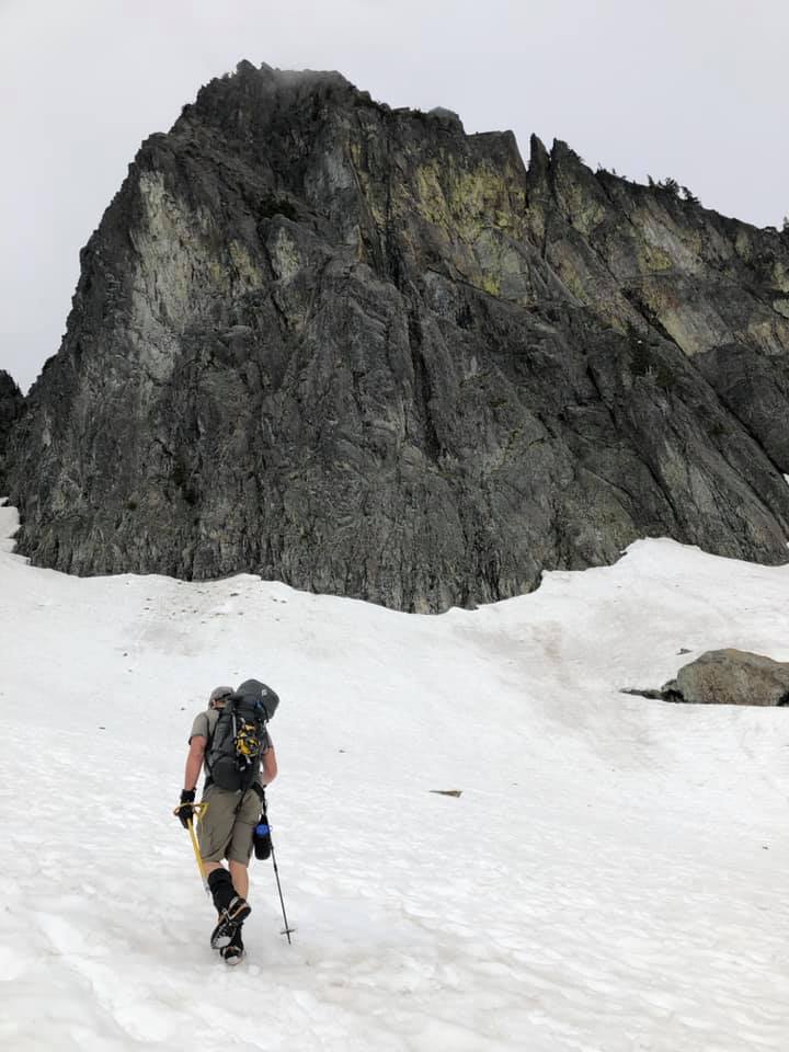
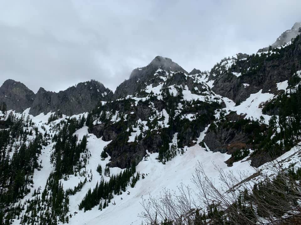
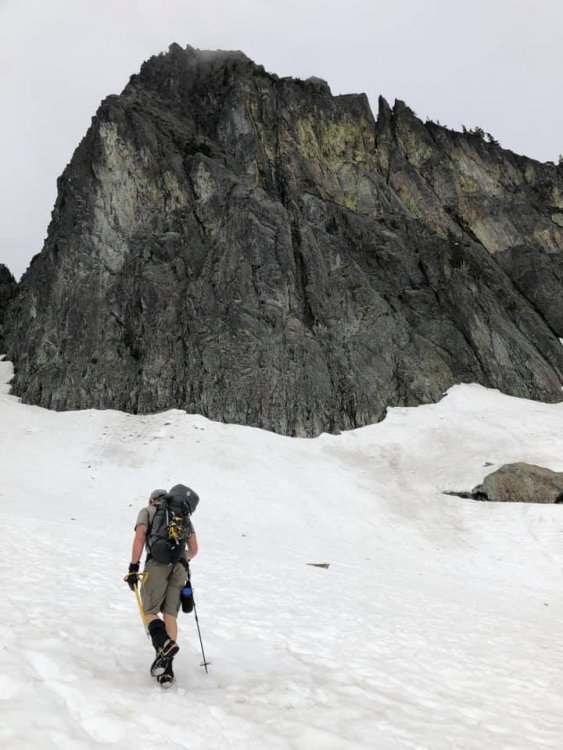
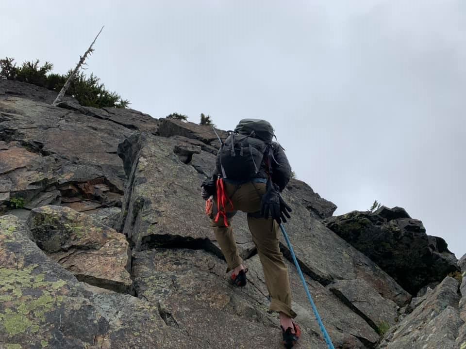
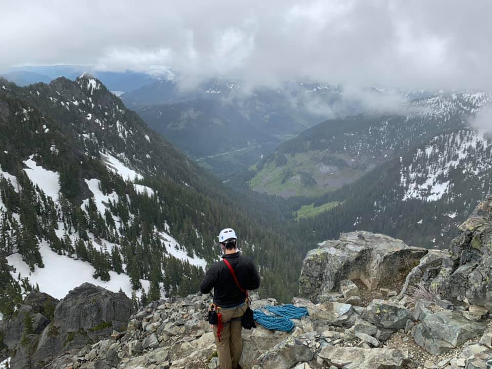
Trip: Colchuck Peak - North Buttress Couloir Trip Date: 06/06/2020 Trip Report: Yesterday myself and two others climbed the North Buttress Couloir on Colchuck peak. We started from the car around 3am, with the parking lot nearly full. After stopping by the lake to filter water around 5am, we got to the base of the couloir around 7am. As mentioned in other reports, the couloir was already in full sunlight. We stayed high and right to enter the couloir, which seemed like the correct choice. Our plan was to simulclimb the entirety of the route. As we started to climb the couloir, we encountered two moats. The first one was passable with some great ice sticks and high steps, while the second had to be navigated around with some very awkward rock moves. This ended the difficulties in the couloir and the rest was just steep snow. We climbed the couloir in two pitches, the first covering most of the ground up until about 300 feet from the notch, and the second to reach the notch. There were plenty of options for protection in the rock, and the snow was decent for vertical pickets. The start of the couloir; the moat is barely visible on the far left hand side. A party of two chose to bypass it with the rock step to the right. Climbing in the couloir: At the notch we led out towards the right about 150 feet, and then started moving upwards. There were a couple of thoughtful mixed moves, as well as an ice step to pull over. Overall the face seemed steeper and more exposed than the couloir. We headed straight for another notch below the true summit, reaching it in a single long simulclimbing pitch. At this point there was a party of two who were soloing who got stuck behind us, as the snow finger was relatively narrow. Once again, there were plenty of options for protection on the face in the exposed rock. Once we reached the notch below the summit, we let the party of two pass us and then led out to the far left, then right up a chimney type feature. This spat us out below and to the west of the summit still. We had one more short pitch with a few interesting fifth class moves to reach the main summit area. We chose to keep our crampons on for all this climbing as there were still some snowy spots. At the notch after the northwest face, climbing up and then to the right: Traverse below the final wall to reach the summit area: We reached the summit around 1:45pm. We ate some food and hung out for a while, then headed down the Colchuck glacier route. After some moderate snow downclimbing, we decided the glacier was in good enough shape to glissade down, even though some people were choosing to walk down. A kind of quick glissade (I'm slow) got us to the lake and our approach shoe stash at 5pm, and to the car by 6:45pm. Overall this was a really fun climb, and it's still in decent shape. The moats will certainly become more problematic as time goes by but it seems like you can bypass them with the rock step. The cold temperatures helped keep the snow from getting too slushy in the sun. Gear Notes: 3 pickets, 0.5-#2 C4s, rack of nuts, a few slings, one ice screw. We placed basically all the gear except the screw. Approach Notes: Stay far right once past the lake and follow snow bands up to the base of the couloir.2 points
-
Trip: The Tooth - Standard Trip Date: 06/04/2020 Trip Report: I've been teaching my kid technical rock climbing skills this spring, and he has been itching to hit an alpine route. With two back-to-back "meh" weekend forecasts we opted for the Tooth midweek on a day advertised as "mostly sunny" on weather.gov. The TH lot has been open for business for over a week now, and we parked at the Alpental/Snow Lake TH lot. Much of lower alpental is melted out and rather than risk some possible schwacking we took the standard trail up to Source Lake. We hit patchy snow a few hundred feet below the turnoff and almost 100% snow from there to the based of the climb. The route itself is completely snow-free. We opted for a leisurely start leaving the parking lot around 7:40. We could see a party on the summit as we rounded Source Lake, and another in the basin. As we ascended, a party of two (also father and son) passed us by. So much for nobody on the Tooth (as turned out 4 more parties followed us that day). And of course it started drizzling rain after the second pitch. I opted for the Catwalk nevertheless as it is ledgy. There were some delays rappeling, but it was not too bad. It's the Tooth, after all. "Mostly Sunny" approach to basin: Yours truly below Pineapple Pass: Summit views with my son: Classic view up P1 on rappel: Victory toast. Now onto bigger and better trips.... Gear Notes: Standard small alpine rack Approach Notes: Patchy snow from 3500'; continuous from Source Lake turnoff; minimal moat issue at notch S of Pineapple Pass
 2 points
 -
Trip: Middle Sister - East Face Trip Date: 06/05/2020 Trip Report: Images: https://imgur.com/a/2r8kVaa Anyone else do this route, #14 from Jeff Thomas's Oregon High, or #15a East Arete? Seems there are no modern TRs. 9:15 PM start 10:15 PM Camp and Green Lakes trails intersection Midnight above normal camping area just out of the woods 2 AM Above final moraine 4:30 AM Above the East Face on SE Ridge 5 AM Summit A couple of weeks ago I got a good image of the East side of Middle Sister and the #14 East Face, green line, and #15a East Arete, blue line, routes looked good, https://i.imgur.com/7lj8kNl.png. Figured it was best to have a go before the next storm cycle this weekend. This, https://i.imgur.com/toFrlVF.jpg, gives the best (though still crummy) shot of the actual route, see the center left snow ramp. This was the first time for me on the Diller Glacier. It sure is nice to have such an easy approach, no steep moraines to navigate. Unfortunately, the moon was obscured in the little bowl that is the East Face and all the pictures I took didn’t turn out. Oh well, I’ll try to describe things. After getting up the lower ramp, I looked for a way to get past the bergschrund. In the darkness I thought I saw a way to get up on the far left but that was a no go. Traversed to the center and there was a super crappy ramp that had next to no support in the middle – nope. Tried to traverse a bit more to the right and found gaping holes in the snow and the rock under my feet like there were multiple bergschrunds. I think the snow and rock was debris from the bergschrund and or crap from previous avy events. I down climbed a bit to keep out of danger and then finally went all the way to the right and found a decent ramp right next to the cliff. I hadn’t seen or heard any rockfall from the cliffs but still, not the greatest place to be. Stayed close to the cliff, and I think there was another bergschrund but it was to the left of the cliff. Got in a moat-ish depression and followed it up probably less than 50 feet until it ended in crap snow and 3-foot hole next the cliff. Traversed left and got into a multiple foot wide runnel. Another 50-ish feet up, this ended too. With more leftward traversing, finally got somewhere near the middle of the face and away from the cliff – big relief. The snow up to that point was fairly firm and even required swinging the tools to get penetration. This didn’t last too long and soon I was just pushing the tools in. The crampons previously weren’t penetrating too deep but now, if I kicked a bit, the 1 – 1.5-inch crust broke. There was probably 3 – 4 inches of not complete fluff underneath but definitely not well consolidated either, bleck. The crust never sounded hollow but breaking through it seemed to cause some sort of vibration, or at least, it didn’t sound great to me. I climbed as gingerly as I could to stay on the crust and not cause a slide. The rest of the climb was fairly easy. The slope was probably 30 – 40 degrees. There were some open holes in the snow further up but they were easy to navigate around. I angled to the left a bit and got up to the SE Ridge, happy to be out of harm’s way. Had the summit to myself and watched the sunrise from further down the standard route. The wind was non-existent except on the very edge of the SE Ridge and the summit, maybe up to 25 MPH. Ran in to the climber that camped the previous night and chatted a bit on the ridge above the Hayden Glacier. This route might be fun when in condition but that probably won’t happen until next season. Gear Notes: Helmet, crampons, axe (didn't use), 2 tools Approach Notes: Normal Middle / North Sister approach except stay to climbers left coming up the final moraines and then veer left to get to the route - see attached GPX.1 point
-
Awesome, looked like a beautiful day. For me, that route was a gateway drug for winter/spring mixed routes. Chose to do it in January years ago and it was a mini epic.1 point
-
Nice! Looks like better wedder than I would have thought. I worked on my fence in the rain. Go figure.1 point
-
yeah, that block just sitting there was "interesting". I've been there though where the upper snow ramp is mostly melted with a bad runout to climber's right. At the moment that's not there at all (as you know)1 point
-
Trip: Mt. Hood - Yocum Ridge Solo Trip Date: 03/21/2020 Trip Report: "It's not my imagination, I've got a gun at my back!" -Revenge, Black Flag Yocum Ridge is the first route I ever thought about climbing. I remember looking at the striking line from the bus stop in my elementary school. Even though I knew nothing about climbing at the time, the sheer beauty of the route captivated me. As I have accumulated some knowledge about climbing, I learned the route wouldn't go down so easy. Something about the jagged ridgeline dulled by rime gives Yocum a special sense of beauty. Today I set out to realize a childhood fantasy of mine. 3:00 and I'm starting the slog up the mountain. My morale is already low because I forgot my headphones. This damn climb is going to make me absorb the sounds of nature! Two hours or so of walking takes me up to Illumination Saddle. Here I lay eyes on the silhouette of Yocum ridge by headlamp. Nerves turn to excitement as the clock strikes 5:00. The glacier crossing was easier than I expected thanks to all the action the route has seen over the past few weeks. The footprints take me to a headwall a little to the right of where the guidebook says to go. The squeaking and ringing of my ice tools puts me into a trance. After about 150 feet of steep-ish climbing, I gain the ridge. Yocum starts off with a tease. An easy and welcoming rime stepped staircase obscures the rest of the ridge from view. I'll play your game. When the first gendarme comes into view, I have to fight thoughts of doubt coming into my head. At first sight, the rime covered sentinel looks steep and unforgiving at every point. The closer I get however, the clearer the line becomes. My cold helmet feels like a gun against the back of my head. I know it's time. I start to the right of a cave and quickly cut left. The ice feels solid and I flow through a steeper gully. 30 meters or so in, I arrive at the crux. Solid snow and ice turn to dead vertical swiss cheese. Through delicate movement and prayer, I fire through the crux. Each stick felt like a weak handshake. The section required commitment to tools placed in an unknown mixture of snow/ice with dubious feet. Finally, I reach the top of the first gendarme. My blood pressure drops slightly as I soak in the beauty of the bladed ridge that lies in front. Here I am extremely grateful for the groups before me who did the heavy rime clearing and bollard building. From the bollard at the end of the gendarme, I downclimb while on rappel to traverse across an exposed section to a big ledge. This beta worked well for me and seemed to alleviate problems some other groups were having. As I started the traverse pitch to the second gendarme, I felt something fall out of my pocket. I turn my head just in time to see my phone fly down the snow slopes and disappear into the glacier below. Perhaps my phone was the sacrifice the route required. Better phone than blood. Then, like clockwork, a raven swoops by me and perches itself on the tip of the first gendarme. We stare at each other for a minute and I thank him for allowing me to experience this route today. I know that I'm just a guest in the mountains. From here on I felt as if I had permission to continue my journey, hopefully my dues were already paid. The ridge widened the further I traversed down it. Passing the second gendarme was the most secure I felt since getting on route. More slogging took me to another bollard (this time with tat!) off of the third gendarme. I chose to rap north to avoid more thin ridge fuckery. Walking along the steep snow slopes took more energy than I thought. My calves burned and cursed me for bringing two single ropes to rap with. More training I guess. Even though some exposure was still present, I began to meditate with the route. Every swing, foot placement, and movement just felt right. As crawled back over to west side, the sun reared its ugly face, and I began to sweat my ass off. I followed more good tracks around to the right of the final buttress. The last buttress is like a fortress full of impassible walls and sneaky gullies. The first gully I started up took me about 150 feet and ended with impassible rime towers. I downclimbed and again, moved right. Here I could see tracks going to Leuthold from Yocum Ridge. Now I knew I was no longer under the gun. One of the rightmost gullies brought success. I tormented my calves up a few hundred more feet until I topped out the buttress at around 12:30. From the top of the buttress, one final ridge traverse took me to the Queen's Chair. 6 year old Landon would be proud. Looking down the ridge I could see all the minute details that made this route special. Negotiating the route was digging into the alpine bag of tricks and executing. I chose not to tag the summit because I wanted to search the base of the route for my phone (spoiler alert: the phone disappeared into a different dimension). Hiking down Leuthold gave me time to absorb the mountain more. Striking blue accents on rime towers, weird ice formations on the glacier, and the forest just miles away all presented themselves. Days like this make me question the future. I'm sure one day I'll find something that will bring me peace. I often think about Mark Twight saying that climbing can be "too much but never enough." Yocum Ridge was one of, if not the best alpine routes I have experienced. Although it wasn't technically difficult, the sheer volume of spectacular movement truly makes this one of a kind. On the way down I wept. For some reason this route had a different impact on me. Maybe it was the feeling of complete peace and isolation, maybe it was the sheer beauty of it all. Maybe I'm just emotional. I stumbled into the Timberline at around 4:00 and unlocked my car. With the clicking of the lock, my reality had become just a memory. Gear Notes: Basically a sport climb Approach Notes: Attack the ridge at about 8800ft1 point