Leaderboard


Popular Content
Showing content with the highest reputation on 01/22/19 in all areas
-
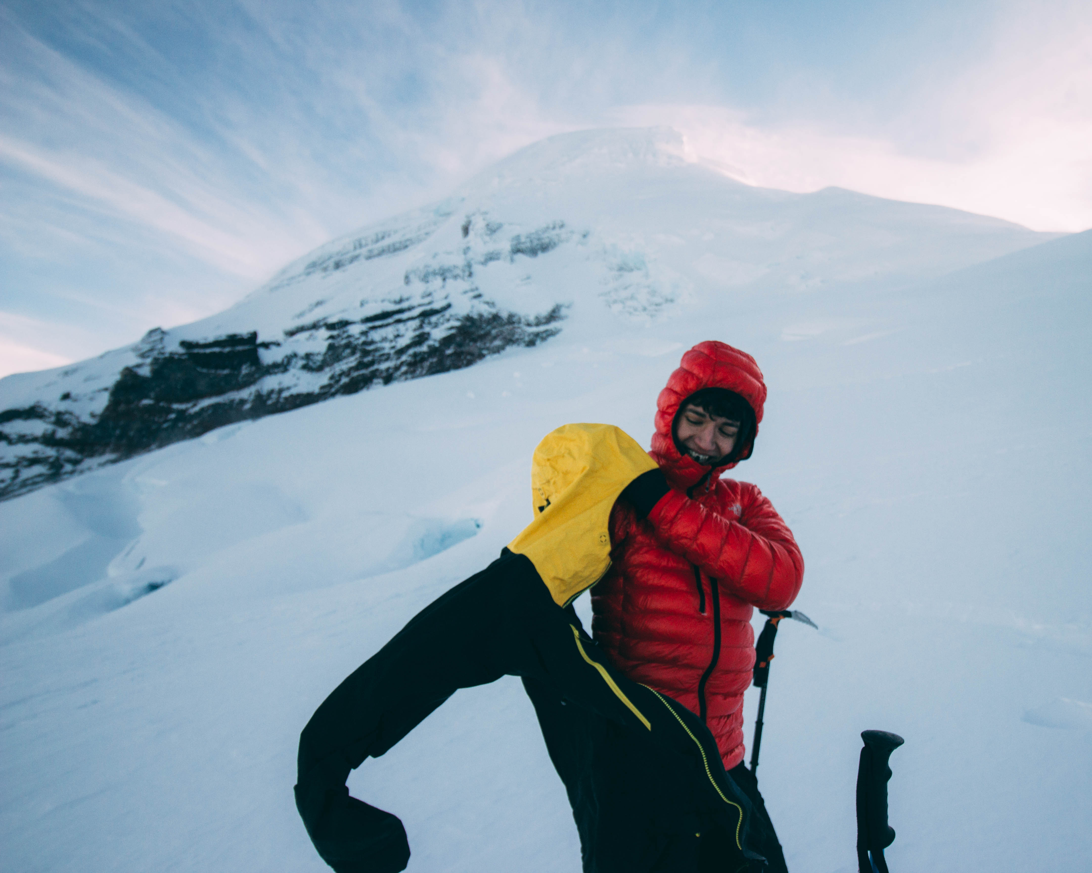
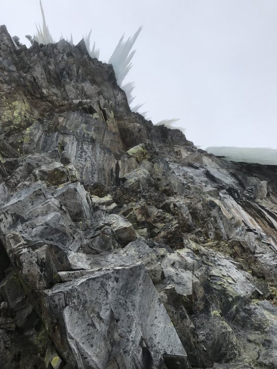
Trip: Kulshan - Coleman-Deming Trip Date: 01/15/2019 Trip Report: I want to give thanks and raise my hands to the Lummi Nation for this safe, successful and amazing trip into their territory and for the company of Kulshan. Drove fairly high up near the trail head with a Subaru WRX, hardly within a 10 min. walk in fact. Super awesome, just need to navigate a thick berm roughly 3 miles down from trailhead. This short distance probably saved us an hour, so starting by 0345 looked super good. Skinned maybe 15 minutes on road before reaching trailhead, transitioned into walk mode on some thin forest coverage. Trail was 95% clear until it wasn’t. Walked for around 40min – one hour before switching into touring. Gained the bottom of Heliotrope Ridge. I was able skin directly up in Magic Carpets, sadly my buddy was forced to carry with his set of mole-hairs. Upon gaining a lower terrace of the ridge, we encountered two gentleman who were super stoked on their coming attempt on Cosley-Houston route on Colfax. After stoking each-others’ fire, we parted. Shortly after we threw on ski crampons, which turned useless as I fell about 5m about hitting their tent. Sorry guys, it hurt my pride than anything. So thus, started the stair-master climb for about 1,000’ up to around 6,8000’ where we returned to the sweet skinning life. Gliding out towards the far skiers’ right of the ridge, after examining the route we pressed on maintaining a high traverse along the flanks of Coleman-Deming. Moving towards the center of the football field, encountered possible wind deposited snow, was harmless but still there. From there navigated through football field, opting for a middle-ish route, towards gaining a small hump parallel to a fatty which was slowly filled in. Containing only one real bridge crossing, it appeared to be filled in more to the right (skiers’ left) and surely with quick movement – or luck – it held, providing no gut-wrenching moments for either of us. Moving forward, the glacier turned more into terraces featuring zigzagging crevasses, although small, daunting and thinner than expected. The decision prior to the climb was to not bring crevasse kits in expectation of a larger snowpack, it will be there after this storm cycle this week but not thick enough for my taste. Thus, below the serac directly skiers’ left, we turned around. Switching back to ski mode, careful navigation down was required. Once reaching 500’ lower, we encountered the two men from around 5am – they were not so stoked this time as they were death marching along our path in boots. Anyway, continued back our ascent path, but opting for gaining the top of Heliotrope for a small photoshoot. Enjoying the clear skies and beautiful company of Kulshan, we had not failed at the end of the day. The ski down, for me, was alright. Not the best with weight on my back, it looked quite more enjoyable for my buddy though. Seems like the route would be much better all-around after a good cycle. Followed ascent path down, was able to ski a solid distance into the forest before carrying skis for maybe 20-30 min. Upon reaching the trailhead, the forest service was delightfully groomed. Back to car around 12, Bellingham 1330. Drove out to Bellingham for a fat burrito lunch and beer – highly recommend, their Mexican food options were superb. Photos courtesy of my awesome homie, Billy K., he's da man Gear Notes: Ski crampons, whippet, crampons, ice axe Approach Notes: Forest walk was alright, just bring some music.

 2 points
 -
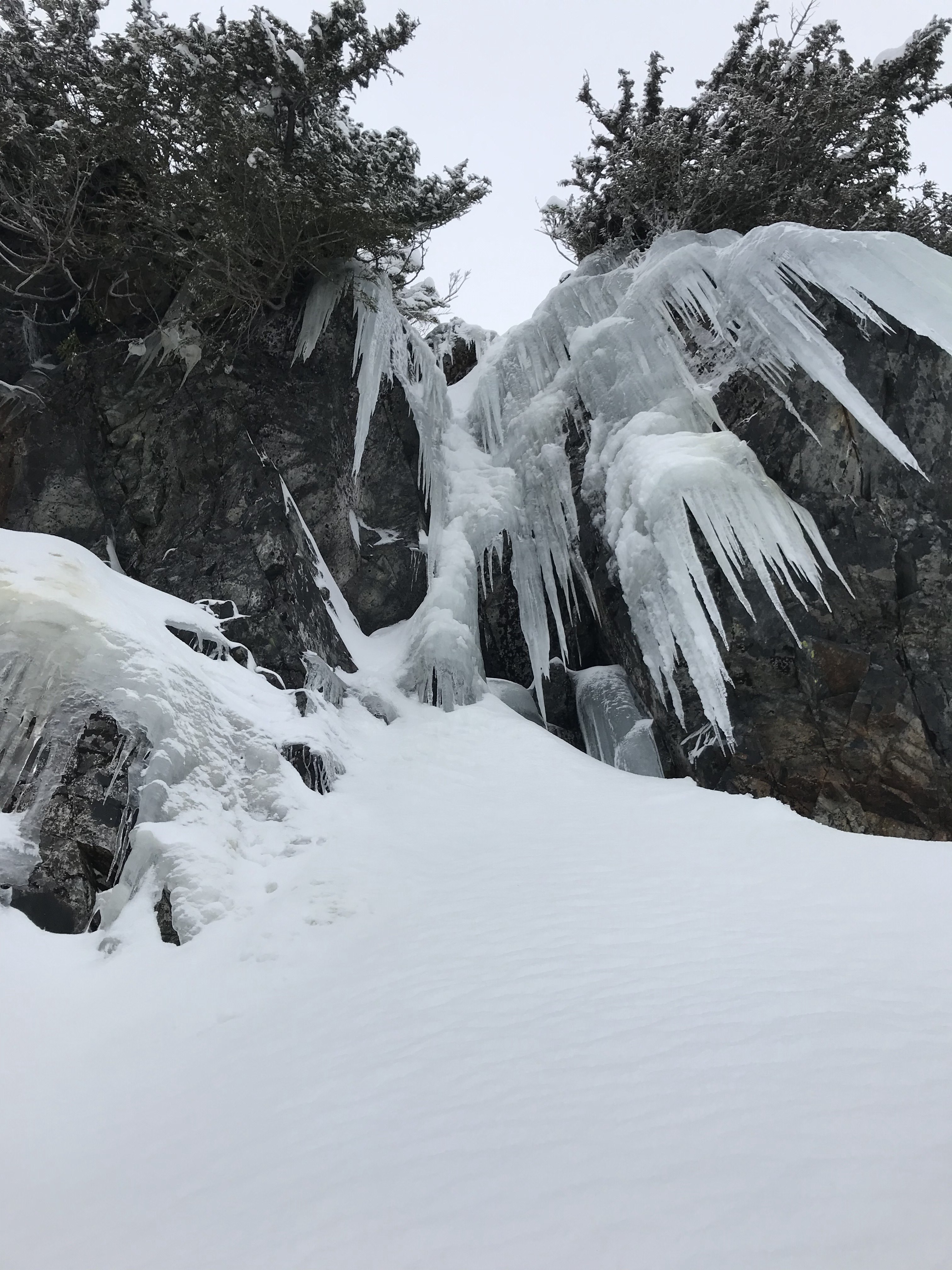
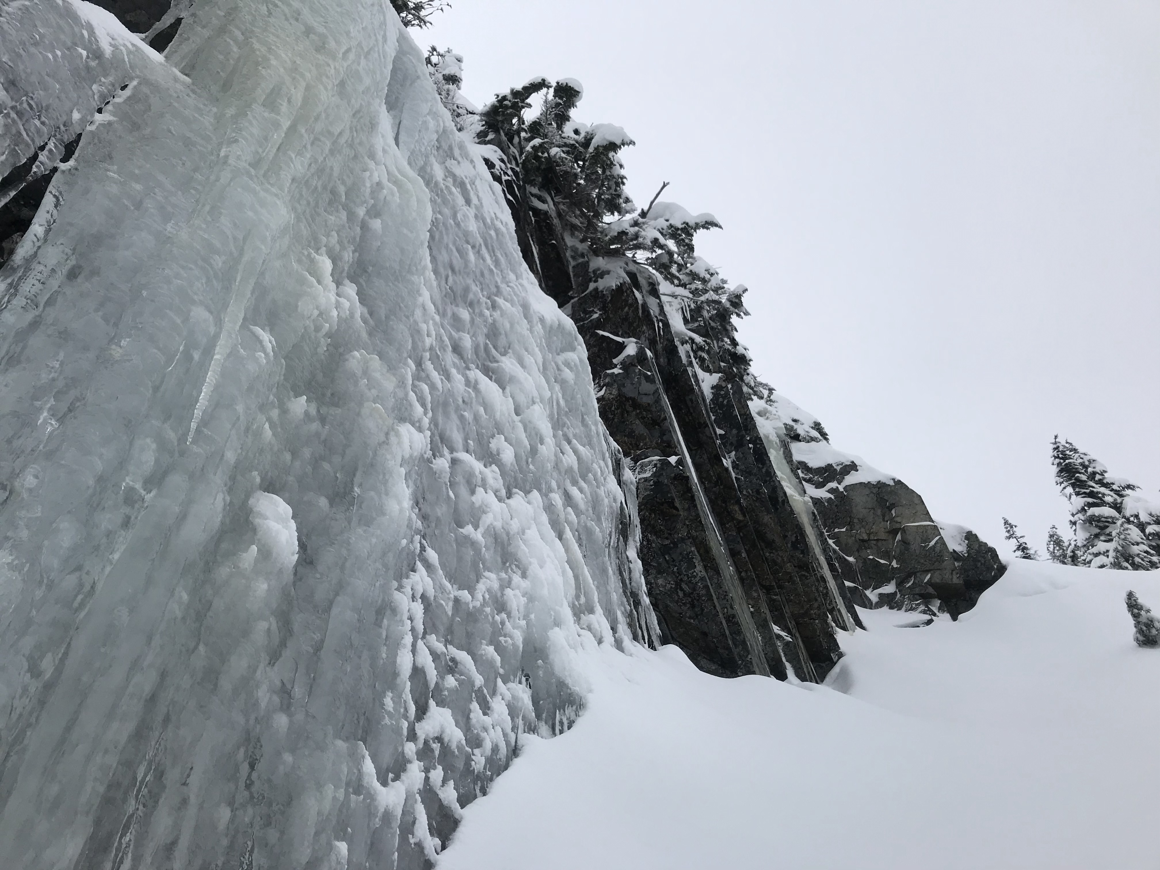
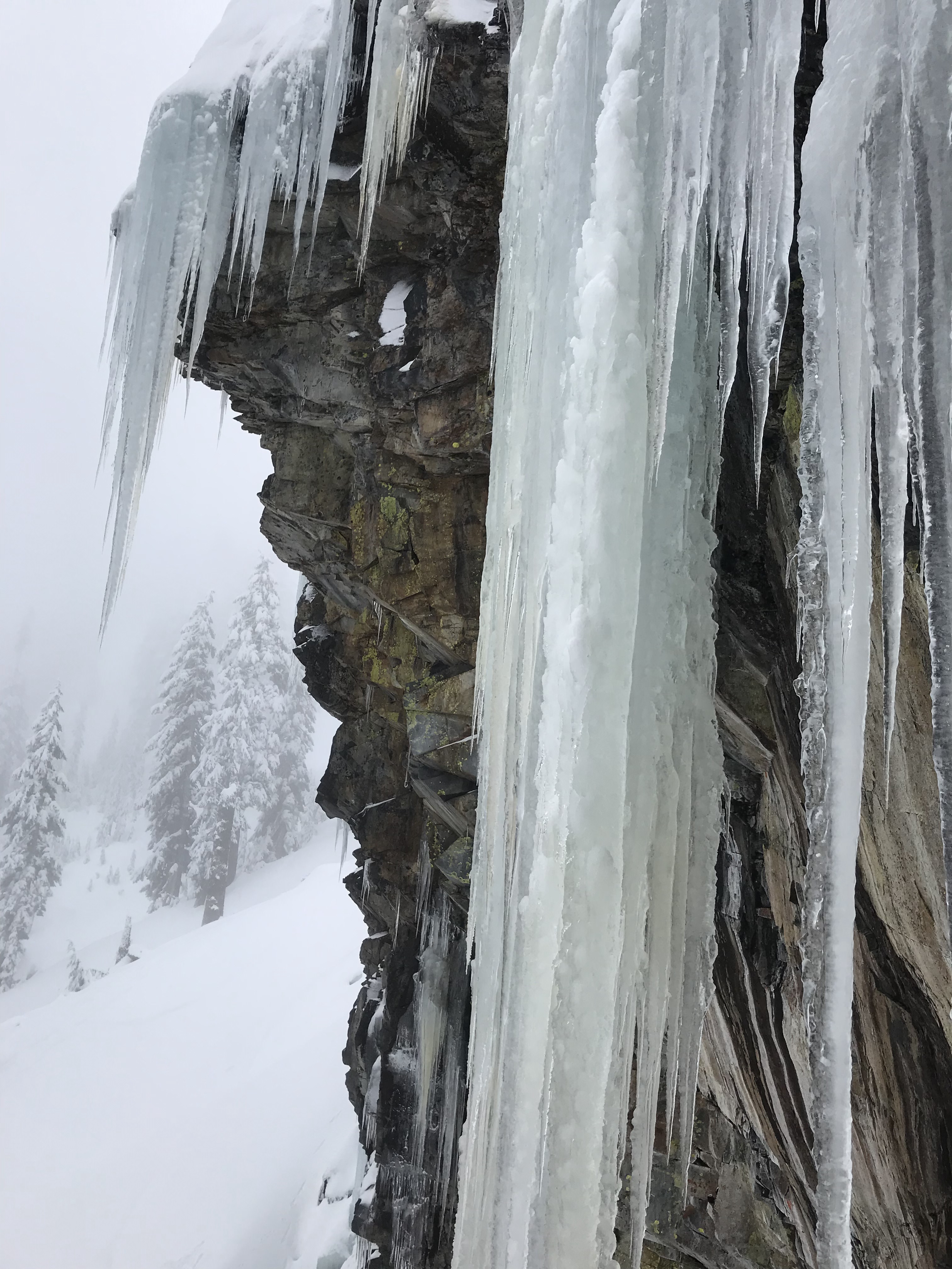
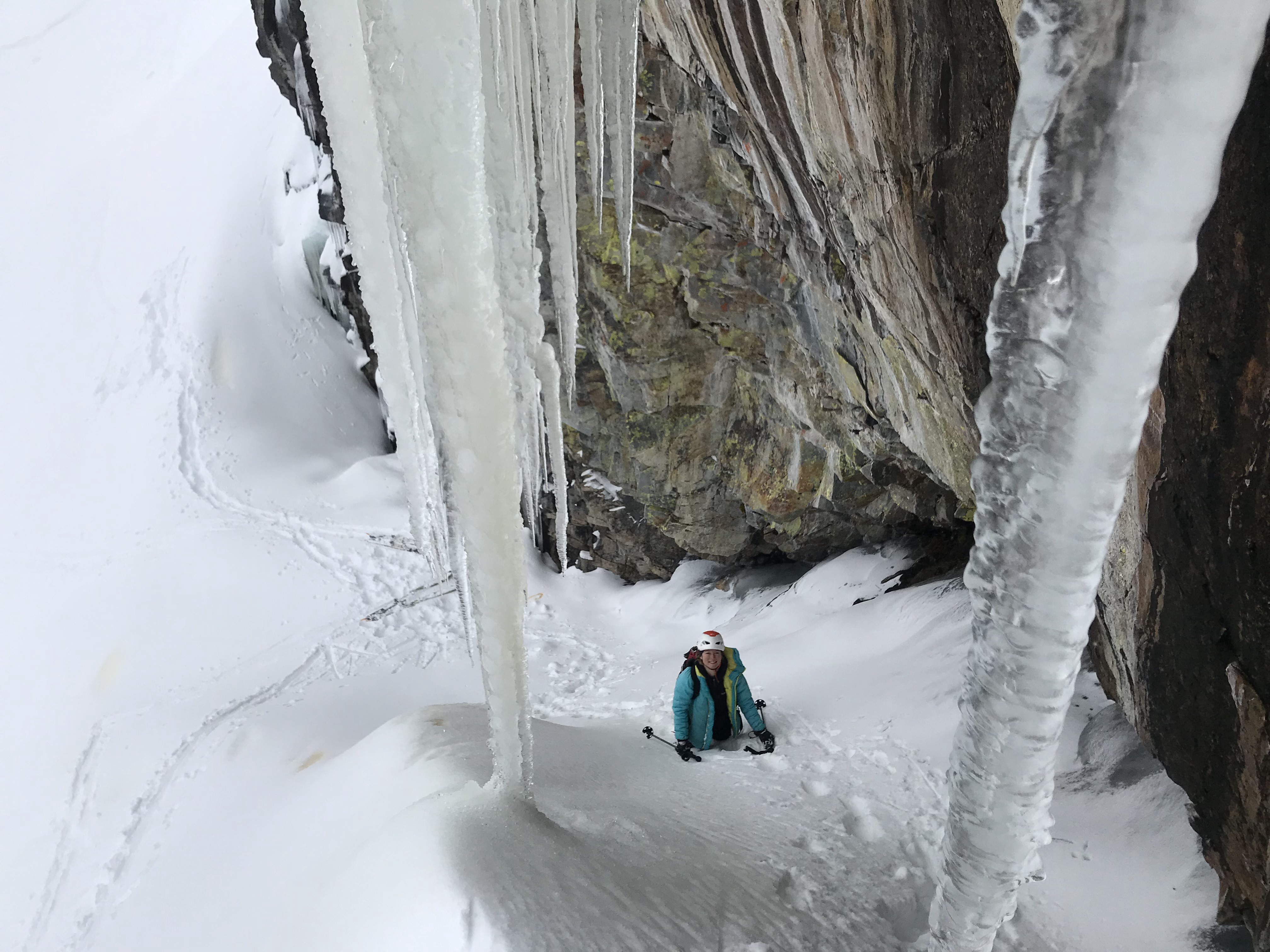
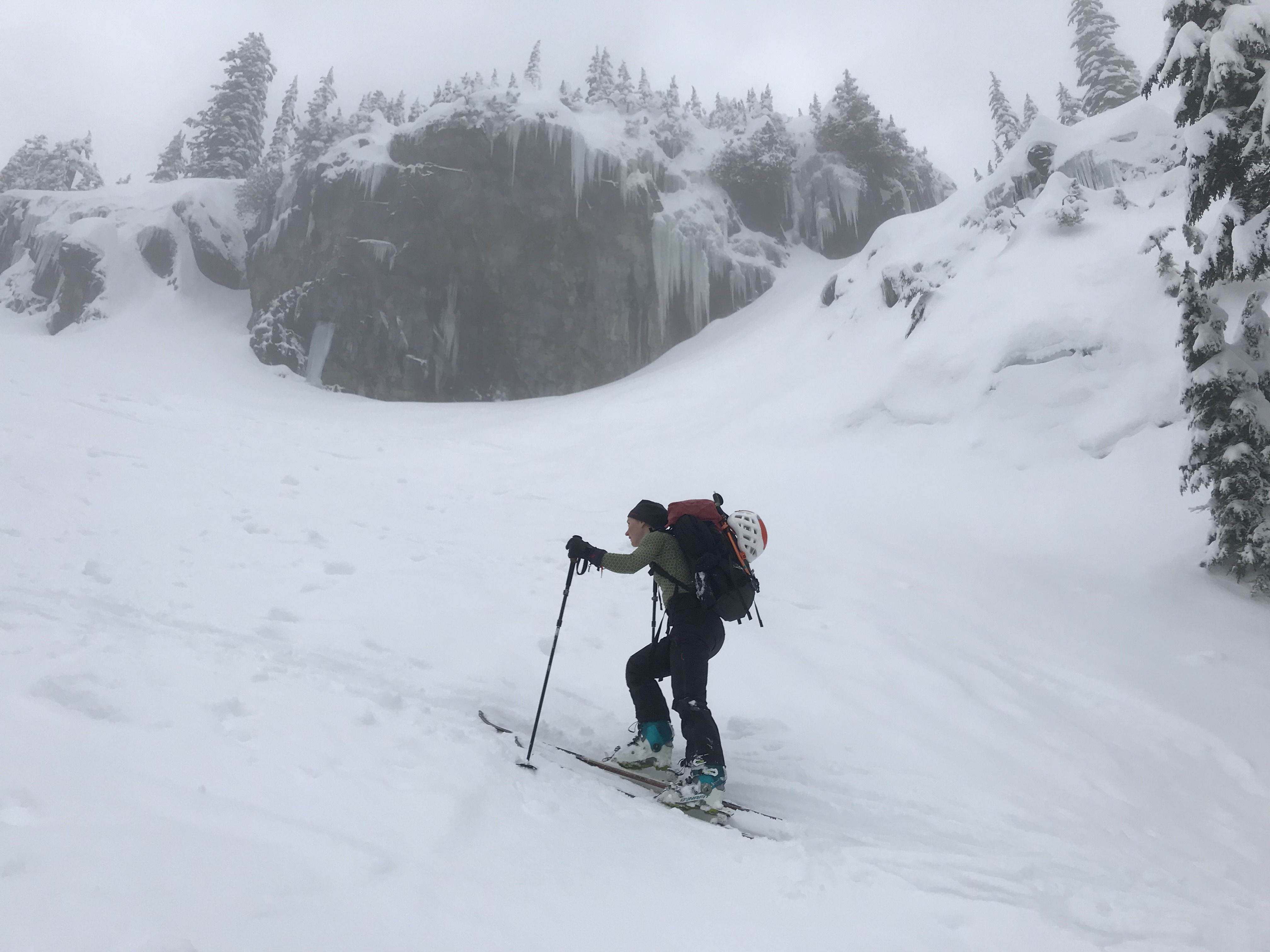
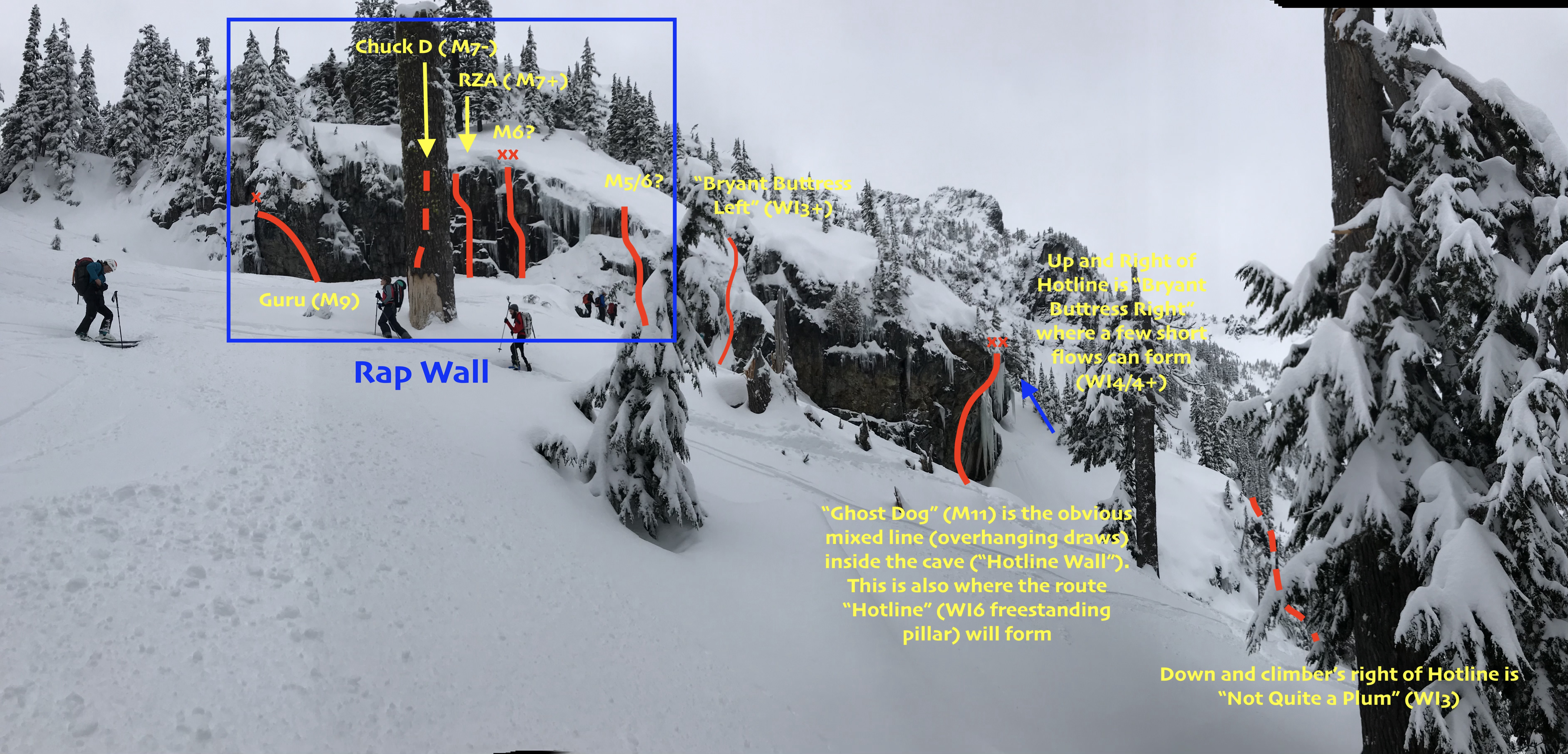
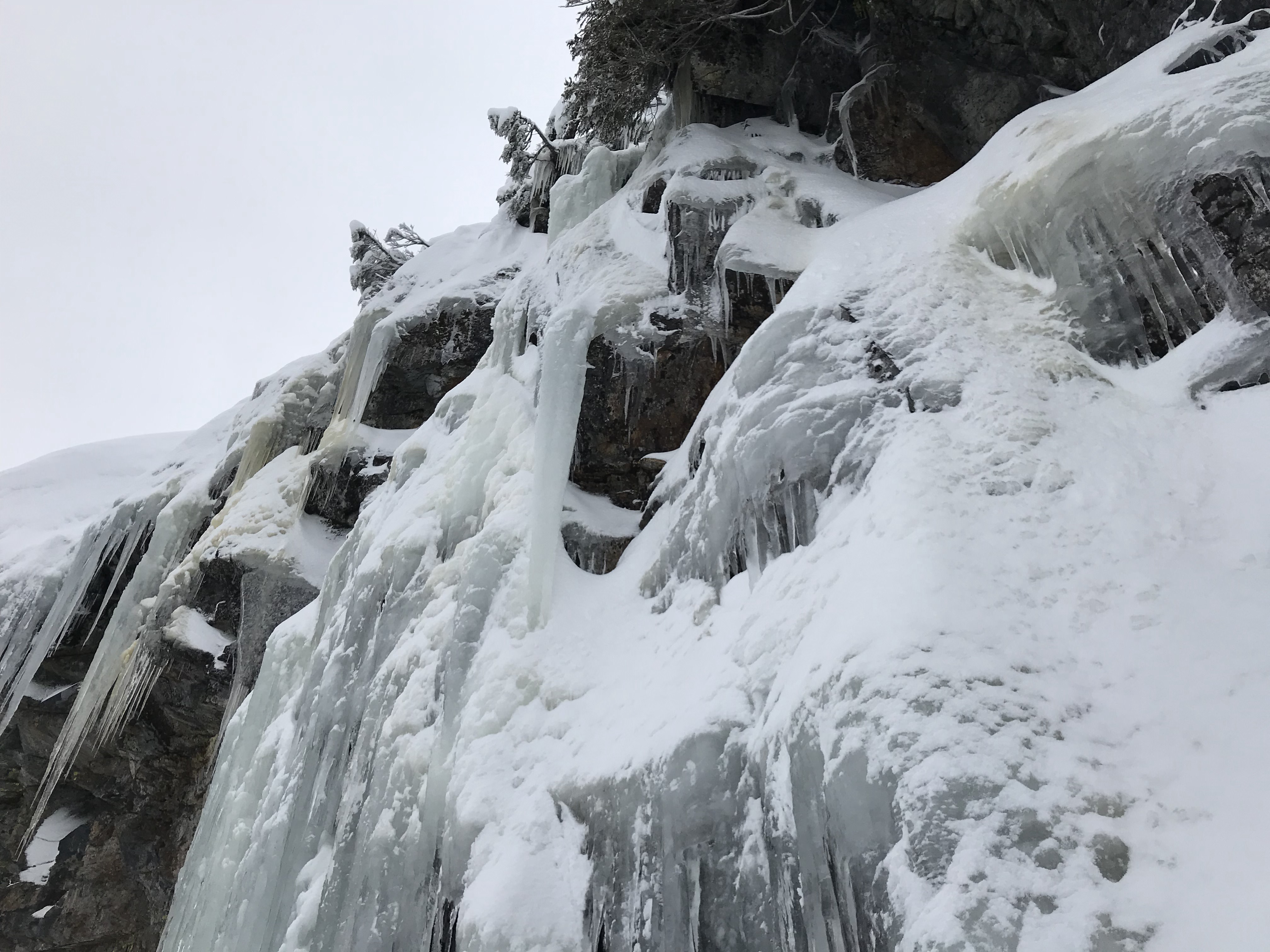
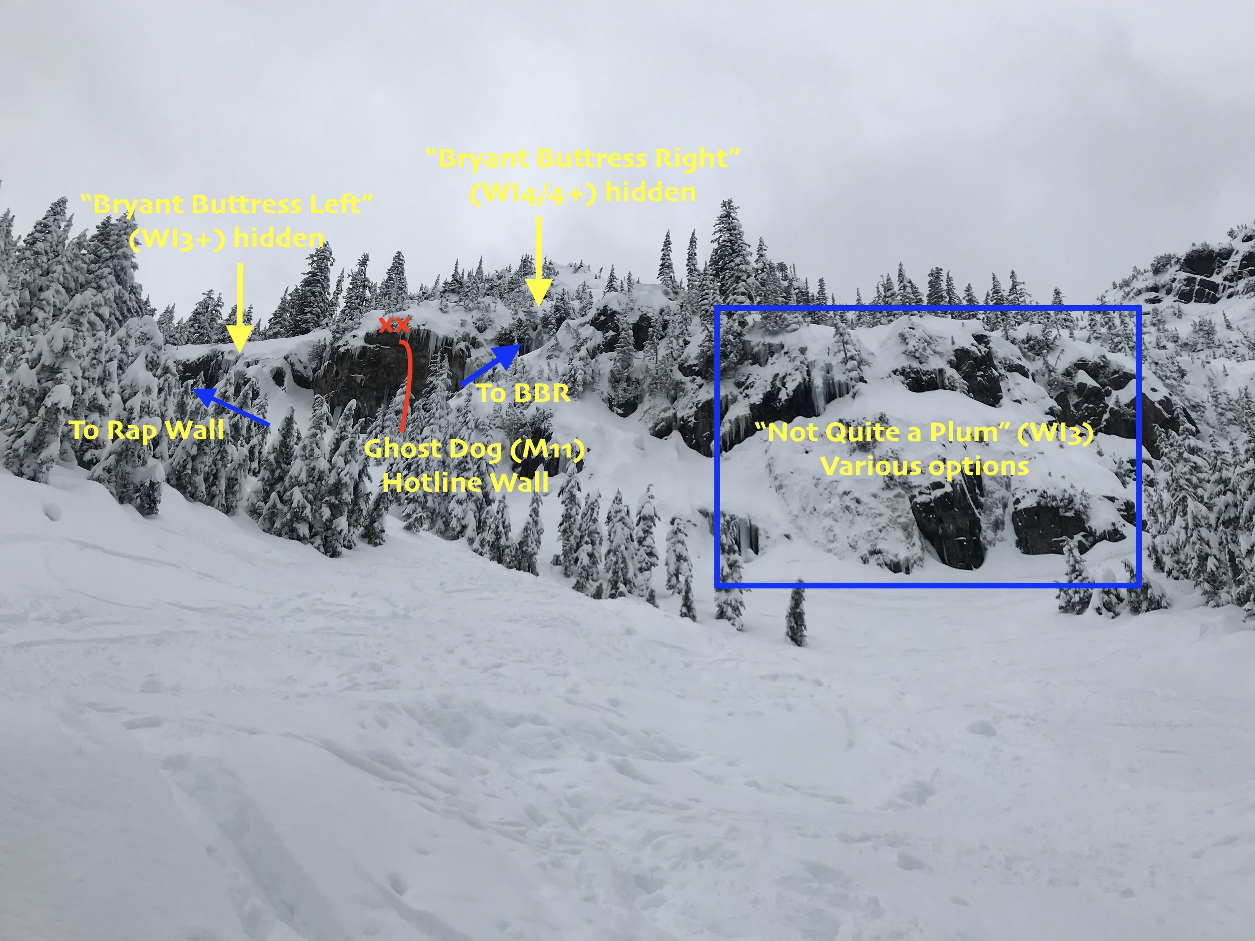
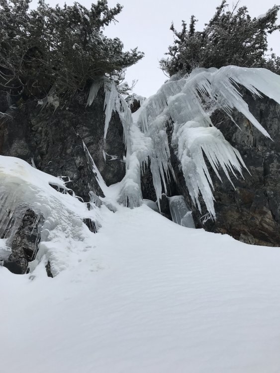
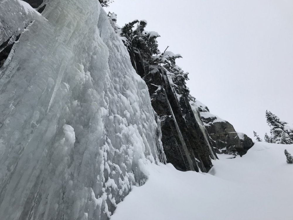
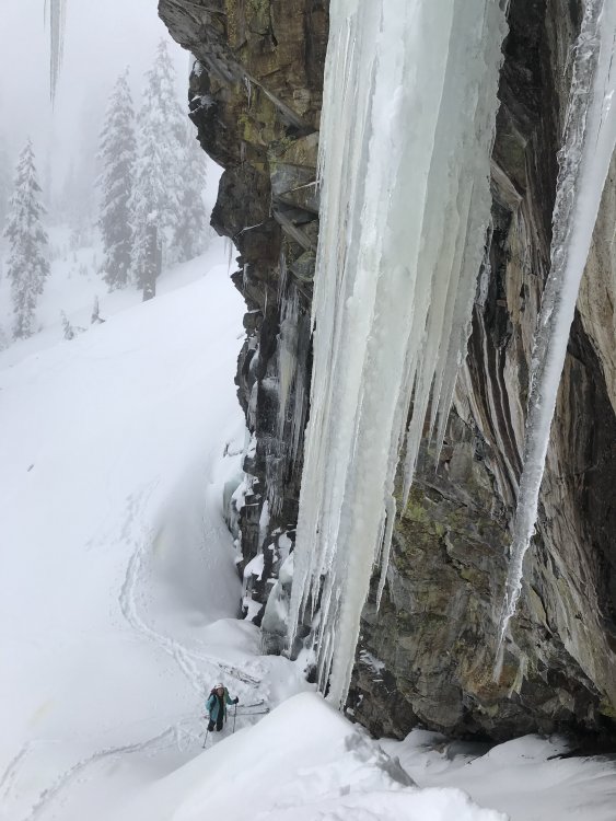
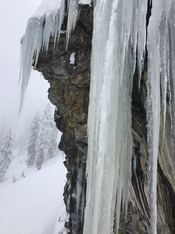
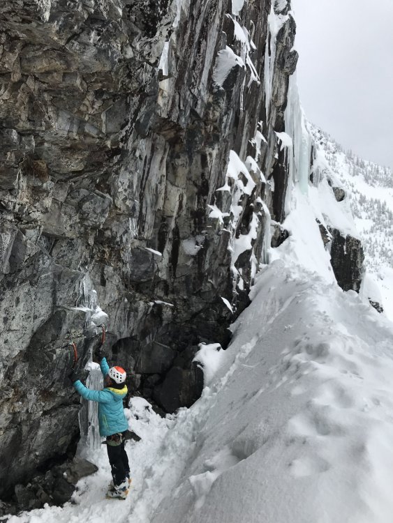
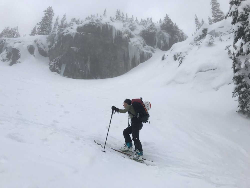
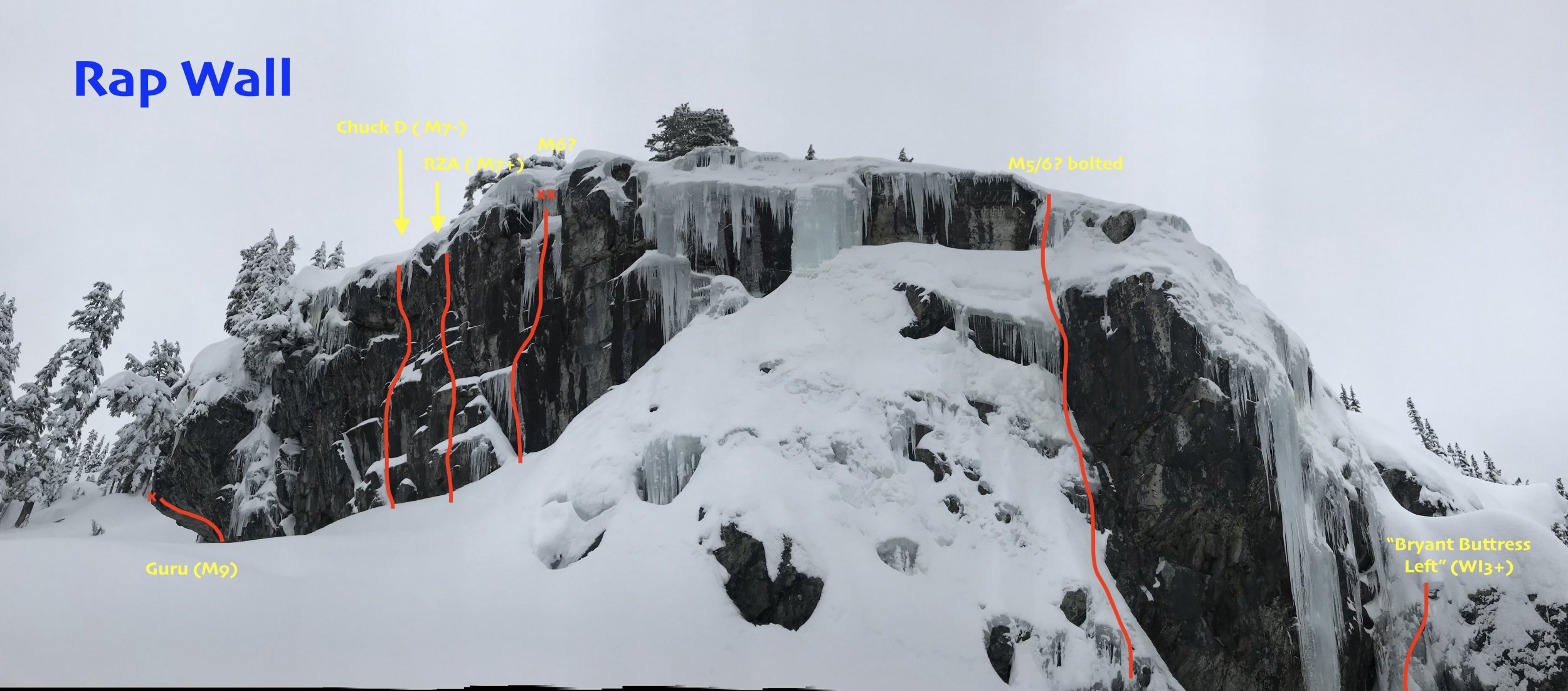
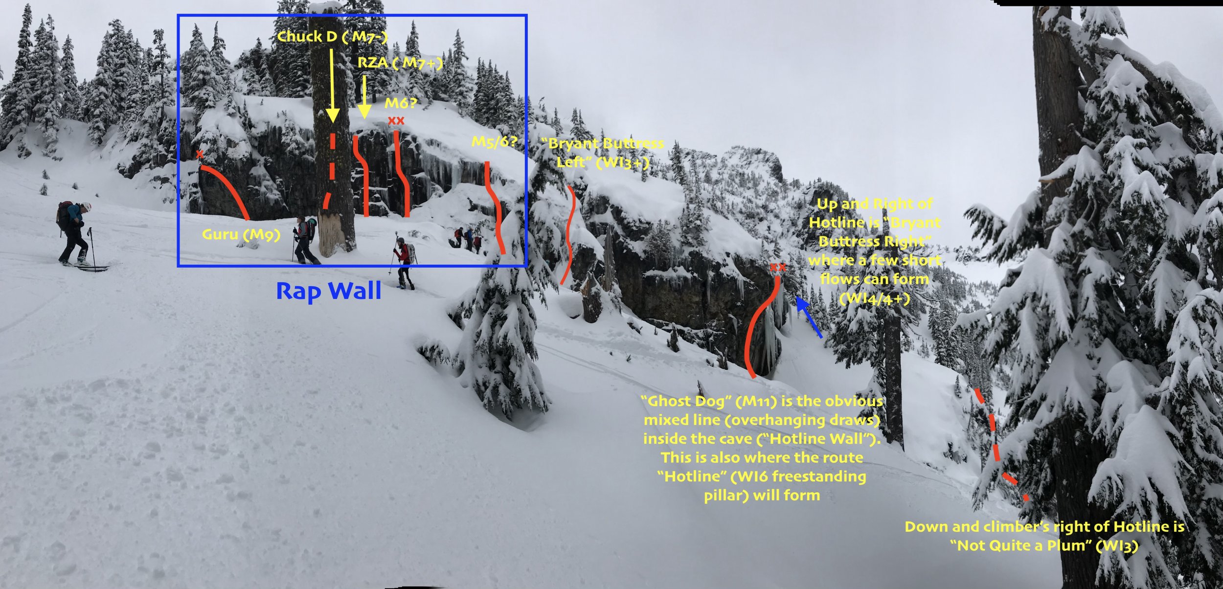
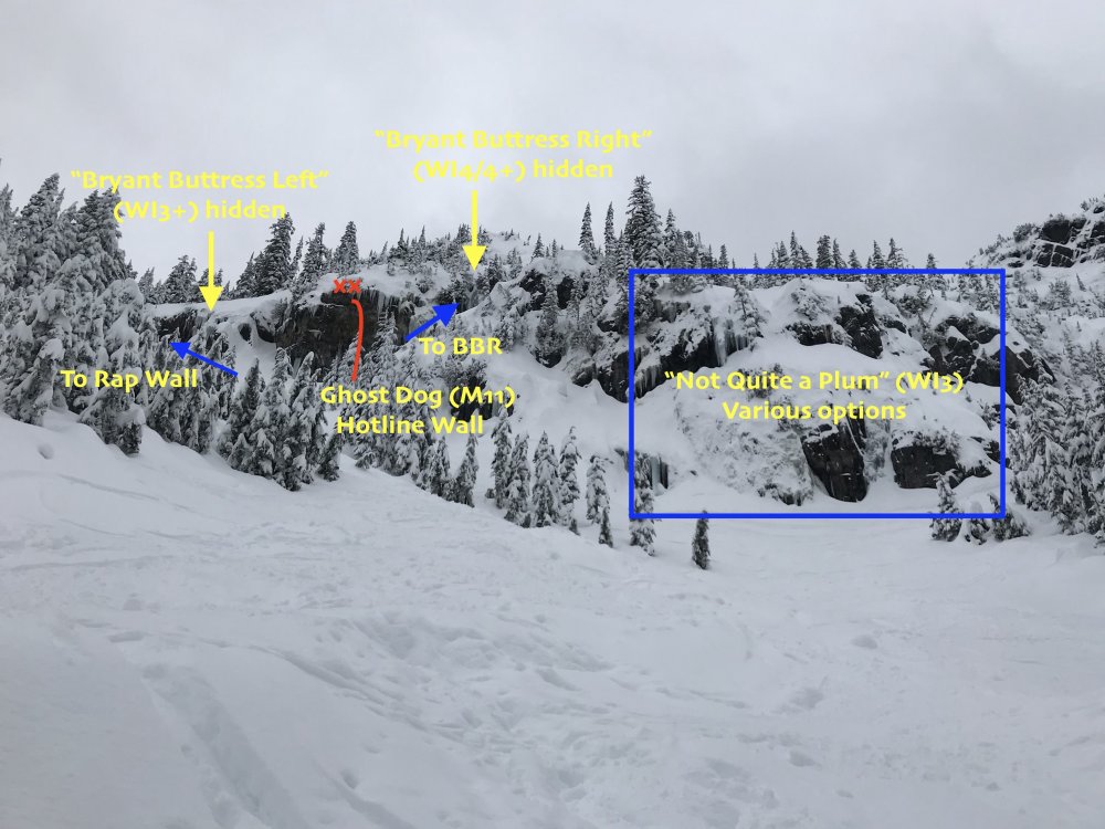
Trip: Alpental Source Lake - Rap Wall Trip Date: 01/20/2019 Trip Report: This was Priti and I's first pilgrimage to lay eyes on and pay homage to Rap Wall. We brought the tools and rope for a walk but had no idea what we were in for. This was a scouting mission to a get a lay of the land. I've since pieced the various Bryant Buttress routes together using the Washington Ice book and various trip reports/blog posts. The GPS Coordinates in WA Ice are spot on, btw. For an aerial view, see page 24 in the book "Backcountry Skiing Snoqualmie Pass": the number "2" is just over the climber's left-most flank of Rap Wall. Also, GerritD has a good far-away look in his comment here: Route Overlays: Since I couldn't find a good topo of the area anywhere, I overlaid some photos with some of my guesses. Please *respectfully* correct me, and I will update the overlays. Left to Right: Rap Wall, Bryant Buttress Left, Ghost Dog (the only route in the cave, aka "Hotline Wall"; the "Hotline" route is a freestanding pillar that will occasionally form over the cave), Bryant Buttress Right. Below Hotline Wall is Not Quite a Plum Conditions: -Alpental Falls: Not in -Kiddie Cliff: Not in (some short, thin ice on the right?) -Not Quite a Plum: short ice steps and deep snow -Bryant Buttress Right: Interesting, thin WI4/4+ flows! -Hotline: the right side of the Hotline Wall has an interesting-looking, steep WI4 traverse-y thing -Bryant Buttress Left: In mixed conditions (gear?) -Rap Wall: Icicles at the top of the cliff band. May want to rap in and hack them off first, so you protect the belayer? Some interesting WI3/M4 lines on the right side of Rap Wall (visible in pictures above) Approaching just beneath Hotline Wall (Ghost Dog) Interesting traverse up and right of Hotline Wall. Looks like WI4 traverse out left, then up for ~15m with good stubbies. Short, wide, thin sheet of WI4 on Bryant Buttress Right (further up and right from Hotline Wall). Continuing even FURTHER up and right from Hotline Wall (right of Bryant Buttress Right) is little mixed gully which could be fun. The cave at Hotline Wall Overhanging top of Ghost Dog Peering up at Ghost Dog. Can you pick out the swaying quickdraws? Very comfy spot to stash packs at Rap Wall (between Guru and Chuck D) Approach: Park in the furthest lot up Alpental, then take winter trail to Source Lake. Once you arrive at the lake and the terrain flattens and opens, up and climber's left is an open gully (visible in the third picture below) and you will see "Not Quite a Plum" and "Hotline Wall" (the cave where "Ghost Dog" is). You can easily skin up the left side of this gully. Gaze upward at the visionary line of Ghost Dog in the cave and pick out the dozen or so quickdraws blowing in the wind up and through the roof. In the book "Backcountry Skiing Washington Pass", this line is called "No Fog" and is also the approach to The Tooth (which cuts back way climber's left). If you were to continue up and left, you will get to Great Scott Bowl, Pineapple Pass, and The Tooth. If you are skiing down, stay in the open glade just below Rap Wall ("one of the best pow runs in the valley") since the open gully on skier's left (just below "Not Quite a Plum" is chunky and unpleasant right now. Gear Notes: Bring lots of stubbies. An adze to chop out bolts and anchors. Pickets if you're trying to rap in and set a top rope. Some routes are truly mixed, so sharpen those points. Approach Notes: Deep snow. Floatation required.


 2 points
 -
Trip: Mount Saint Helens - Worm Flows/Moniter Ridge Trip Date: 01/14/2019 Trip Report: Mountains are a huge part of my life. I return to them as often as I can, gaining mental clarity, physical fitness, and memories of adventures with friends. I grew up in Minnesota, far from any mountains, and even before I ever climbed one, I felt their call. It’s very hard for me to imagine living anywhere where I cannot go and experience the positive energy that I can only get in mountain environments. This of course means that it’s really a bummer when the mountains remind me that they’d have no compunction whatsoever about killing me in a variety of unpleasant ways. Mount Saint Helens is probably the single mountain I’ve known about for longer in my life than any other, as I’ve been obsessed with volcanoes since before kindergarten (I’m now a geologist studying them for a living). As such, it felt like a pilgrimage to drive up to try to climb and ski it with my friend Reese last Sunday evening, after living in the Pacific Northwest for six and a half years and somehow never making it up there. Promises of clear skies and relatively warm temperatures (freezing levels between 9,000 and 10,000 ft) with low avalanche danger enticed me to propose the trip, and I went to bed Sunday night in the car at the Marble Mountain Snow Park with dreams of thousands of feet of perfect corn snow skiing. Morning promises of a long ski descent. There was plenty of snow at the parking lot, further fueling thoughts of a ski all the way back to the car when we started skinning up at 5:40AM, under a starry sky. We reached tree line right in time to watch the sunrise, making relatively good time. Even at this early stage, however, there were warnings. Reese repeatedly said that she had a sense of foreboding that she couldn’t shake, a kind of dread of the mountain even though she’d been up similar mountains like Mount Hood in the past. Even so, I assumed once the sun came up we’d both feel better, and that seemed to be the case, so we started up the Worm Flows climbing route past fascinating lava formations amidst beautiful views. In retrospect, this dark feeling proved prophetic. Reese just above treeline with Mount Hood in the distance. At the last trees, we stopped for snacks and put on sunscreen and eye protection, and switched from skins to crampons on our boots. The one black mark on the day so far was the wind, which was typically nasty for a Cascade volcano above tree line in the winter. mountain-forecast.com, if I recall, was calling for 20-30 mph winds throughout the day, which was a bummer, but not enough for me to want to not try to take advantage of the otherwise good weather window. The snow slopes around us were covered in ski tracks from the previous day, with one area we passed even possibly qualifying as a bit tracked out, and this got us both excited for a great reward after the long slog up. We saw a dozen or so other climbers and skiers, some going up, and some descending after very early morning summits. Conditions were very icy, but one of the people met told us she’d heard that things at the summit had softened up for good skiing at about 1:00PM the previous day, so we took a relaxed pace and waited for the corn. The climb itself was somewhat boring, with many hours and thousands of feet of uphill slogging, and it passed mostly uneventfully. I had trouble with my crampons at one point, as my old Black Diamond Sabretooths don’t fit my ski boots particularly well, but stopping to adjust and reattach a couple times on the whole climb in safe positions didn’t seem like cause for particular concern. At several points Reese said she was still feeling nervous and very tired, but emphasized that she wanted to continue to the top. Finally, we reached the final ridge about 300-400 ft below the crater rim, and there the topography made the wind, which was coming from the east, bad enough to make walking difficult, with gusts well over 40 mph in my rough estimate, especially with skis on my back. At this point, I’d gotten maybe 100 yards ahead of Reese, but I wasn’t too concerned, as it’s pretty common for me to get well ahead of or behind my climbing partner on these kind of long slogs, so I made a priority of getting to a point where I could turn a corner and reach shelter. Waiting out of the wind for Reese to finish what were afterwards simply referred to as the “wind ridge,” it occurred to me I’d let the gap between us get too large, so I tried to assuage my guilt by spending a few minutes chopping out a nice deluxe ledge for us to sit on and rest. When Reese rounded the corner a few minutes later, she did not come to where I’d stopped to rest and instead beelined straight for the crater rim. She later told me that she had found the wind awful enough to want to head down, but the wind and the distance between us made conversation impossible, and she decided to get to the crater rim as soon as possible. I caught up to her, and we made the final approach to the crater rim together, and the views did not disappoint. Us on the summit. I wanted to hike to the true summit to the west along the crater rim, and take some pictures of the crater, while Reese told me that she felt satisfied reaching the crater rim, so I took off while she found a sheltered spot to eat lunch. View towards the true summit and the massive crater from close to where Reese rested and had lunch during my summit jaunt. Spindrift at the summit. I must say that the views didn’t in the least disappoint, and I walked along the corniced ridge with a deep sense of awe. Another skier who was resting at the crater rim when we got there reported that the summit had been mostly out of the wind, but I found that to be far from the case, and experienced wild spindrift and intense gusts. On the way back, I found a single gap in the cornices which allowed me to peer down towards the steaming lava dome and take a panorama. Gorgeous view down the barrel of the proverbial gun towards Spirit Lake and Mount Rainier through a gap in the summit cornices. It turned out that I’d misjudged the distance to the crater rim, and the round trip there and back with multiple photography stops ended up taking just over a half an hour, so I decided we’d better get down as it was about 2:30PM and we were definitely running behind our intended schedule by about an hour and a half. I got back to Reese, apologized and said I’d skip lunch in order to make up for lost time, and then things started to go very wrong. At this point, there were three problems which would collectively amount to a serious emergency even if we still didn’t recognize it at the time. First, we were now the only two people left on the summit ridge, as the other skiers left a couple of minutes before I got back to the spot where everyone was resting. This made poor route-finding decisions more likely. Second, conditions were nothing like the corn we anticipated and which the numerous tracks on the mountain seemed to promise us. Instead, the stronger than anticipated wind and slightly cooler than anticipated temperatures conspired to serve us with a huge sheet of rime-dotted ice leading down from the summit, which was seriously unappealing to ski, and was going to require much more skill and effort than we’d planned for. Finally, and most seriously, while resting and eating at the summit, Reese realized that she was quite a bit more tired than she had previously realized, and said she felt cold, exhausted, and dubious about her ability to ski down the unexpectedly difficult terrain. One of the last happy memories of the trip (other than the ending), this wonderful view of Mount Adams. Despite that, a pep talk got us clicked into our bindings and on our way down. The ice was unpleasant, but surprisingly held an edge, and I was relieved to see Reese visibly relax and start making nice turns after a shaky start. That would prove to be the last respite of the trip before our final rescue. I figured that if we crossed the top of Monitor Ridge below the “wind ridge” section which had caused so much trouble on the way up, we could avoid the worst of the wind and get on to our planned descent route. Instead, at the lower crossing we encountered perhaps 50 mph winds and a slope which had been blasted down to smooth ice. It would have been very difficult to cross into that headwind without losing control and tumbling down the slope, so we turned back. In retrospect, we should have given up on skiing then and there, and cramponed over the ridge, but skiing, even in the wrong direction, seemed faster, and with the lowering sun, we headed skier’s right. We managed to descend another 700 ft or so when disaster struck. Instead of giving way to sun-softened slopes as we’d hoped, the edgable, textured rime of the upper mountain turned into equally hard stuff which had been thoroughly smoothed out by the previous day’s thaw and that day’s wind. In what would be in my opinion my most grievous error of judgement of the entire day, I kept leading the way down even when I felt that my edges were no longer really gripping the slope. Finally, on a steep section, I got spooked, leaned into the slope, and began a long sliding fall towards a sharp ridge in the snow about 150 feet below. I deliberately rolled so that I would release my ski bindings and hit it sideways, and piled up debris made the impact mercifully soft. I walked away with only a bruise on my thigh. Looking beyond the drift which had caught me, there was a sickening view of hundreds if not thousands of feet of mostly uninterrupted snow slopes, a real slide-for-life kind of situation, and I realized the kind of awful fall I’d narrowly avoided. I shouted a warning to Reese to be careful of the spot where I’d fallen, but she immediately fell upon reaching the same spot, making the same impact with the snow drift. Google Earth view showing our route and the sites of some of our mishaps. Seriously rattled, we decided to stop skiing and switch to cramponing down the mountain after I made a likely dumb suggestion to continue skiing with and ice axe in hand. We’d barely made it 100 yards traversing a steep slope until I found myself sliding again, this time quickly arresting with my axe. I tried to stand up, and was horrified to find myself immediately sliding again, as my crampon had completely fallen off in the first fall, and was merely dangling by a strap which I’d wrapped around one of the boot buckles to keep it out of the way. Immediately arresting that slide, and pissed at myself for allowing myself to get into that situation, I replaced the crampon, only to have it start to come loose after only a few steps. Having to climb down to retreive a runaway crampon would have sucked, to say the least. Examining the boot later, it seems that repeated use with the crampon had damages the plastic where it contacted the steel crampon, making the fit strangely loose and prone to releasing. It’s unclear to me whether the crampon coming loose caused the fall, which seems most likely, or if the wind merely caused me to slip and the crampon ripped loose in the fall. Just as I was devising a more permanent fix to my crampon problem, Reese lost her footing and went a wild, spinning fall, which it was not at all clear she was going to be able to arrest. Finally, she righted herself and arrested after sliding as much as 200 ft, which is one of the most relieving things I’ve ever witnessed. I caught up to her, retrieved the ski poles which we’d both dropped (luckily, nothing slid so far we couldn’t go get it), and we continued down. At this point, however, Reese’s extreme exhaustion combined with a very justifiable fear of the sketchiness of our situation to slow her down to a near crawling pace down the mountain. When we reached an almost flat spot a few hundred feet farther down, we stopped to consider our options. At this point, it was about 4:00PM and we were running out of light. We decided to text a friend in Portland to inform someone of our situation, but to assure them that we were safe for now and did not require rescue. Shortly afterward, Reese convinced me that we should send a follow up suggesting that we were in fact, not safe, and required a rescue (I did not call 911 myself to save phone batteries for what I was beginning to assume might be a long night). Reese also began to be visibly clumsy and started shivering. If nothing else, helpd to settle my doubts that the decision to call for help was justified. Covering the red line took us 11 hours, and we were slowing down. Without rescue, we were definitely going to be in for a rough time. Assuming that help was many hours away, we began very slowly descending. I advocated that we dig a snow cave and eat and take an extened rest while waiting for help to arrive, while Reese was adamant that we not stop moving downhill. Before this could turn into a real argument, however, a rescue helicopter flew overhead, and we waved at them until they circled, clearly noticing us, and then flying off. Moving slightly farther down, we say two other people just a couple of hundred feet below us, and we moved to go meet them. Miraculously for us, they were in the same situation, having just experienced a long sliding fall, coupled with extreme exhaustion, and they had called for rescue, the chopper was for them. A few minutes later, the helicopter managed to drop a couple of members of the Volcano Rescue Team off, who accompanied the four of us a bit farther down to a point where it could land and shuttle us all down to our cars just before it got dark. It brought Reese down first, along with one of the other party, then came back up the mountain for me and the other member of the other party. My first ever helicopter ride reduced what would have been a multi-hour epic to a bouncy jaunt that lasted maybe three minutes. Your friendly neighborhood mountain rescue helicoptor. In retrospect, this misadventure was the product of several errors in judgement. Chief among them was summitting in the first place, dooming us to a complex descent in poor conditions. In my zeal to reach the summit and see into the crater, I ignored a long series of small but clear red flags in the form of Reese’s repeated comments that she was uncomfortable with the entire situation on the way up. We likely would have been ok if the weather had been a bit better, but we didn't collectively have enough in the tank to descend in anything other than ideal conditions. I’m also ashamed of the way that I skied without adequate means to arrest, especially because I could have had my ice axe in hand with little extra trouble. My crampon-related fall actually didn’t scare me nearly as much as I never personally felt like I wasn’t going to be able to arrest once I had the damn axe in my hand. I also didn’t bring a stove or emergency blanket with me, which would have made a night out much more palatable. I am at least happy that I still had a bunch of extra food and water with me still at the point where we were rescued. In any case, we are indebted to my friend in Portland who called rescue on our behalf, to the Volcano Rescue Team, and to the Clark County Sherriff’s office for preventing an epic. Also, there’s probably something wrong with my brain, but I want to go back in better conditions and ski that hill! Gear Notes: Skis, ice axe, crampons. Should have brought my whippet, but only had normal poles. Approach Notes: Easy, well signed approach from Marble Mountain Sno Park.1 point
-
The gully is the bottom of the colloquially named "No Fog Bowl." Beware of skiers dropping down from above. I know people occasionally will ski down "Not Quite a Plum" and where your arrow says "To BBR". Fun stuff! Thanks for the info, I've been wondering about the climbing up there.1 point
-
any chance you took some close ups of colfax i.e. CH and Polish Route? Thanks!1 point