


BlackHawk
-
Posts
22 -
Joined
-
Last visited
BlackHawk's Achievements
")
Gumby (1/14)
0
Reputation
-
Another great trip report w/great pics and I'm really surprised that the glacier is still in such fine shape. A NW classic and your time makes it seem like the trail is totally logged out or something - which it is not. As I mentioned, we went up to try out the Rainier DC/Emmons variation on the 14th and found it to be an interesting alternative to the dusty old cleaver. For most of us it was a 9 hour roundtrip from Ingraham Flats.
-

[TR] West McMillan Spire - West Ridge 8/14/2007
BlackHawk replied to off_the_hook's topic in North Cascades
Wow, another great trip! Time for you to head over and give Jack Mtn. a shot - probably not much left in the way of glacier or snow traverses this time of year and it would be an easy day trip for you. -
[TR] Fernow, 7FJ, Maude - Speed Climb 8/11/2007
BlackHawk replied to off_the_hook's topic in North Cascades
That was not only a superfast climb, but you burned a lot of calories heading up those 9K plus rocks for sure, however, I would be more impressed if you had taken the Carne Mountain High Route back and tagged 7K Carne as well. The old sheepherders high route is still there but it would have slowed you down in places, until you hit the Carne Mountain Trail that drops in on the Phelps Creek trail about 1/4 mile from the parking area. Awesome job and great pictures! What's next - Logan, Storm King, and Goode in 12 hours? -
No, I didn't see the chopper but I heard it around 4pm and I was already back on the fryingpan. That would have been an awesome photo.....
-
Trip: Little Tahoma (Troubles spotted on DC) - East Shoulder Date: 7/28/2007 Trip Report: To celebrate my birthday I day-climbed 11,138 foot Little Tahoma peak in Mount Rainier National Park solo. Doing this trip in a day involves roughly 14 miles (roundtrip) of hiking and about 7,300’ of elevation gain/loss. Doing it solo requires care and consideration and if you spend any time on the summit at all you are looking at about 12 hours car to car. From Seattle it took about two hours to drive to the Wonderland Trail’s Fryingpan Creek trailhead in the National Park where I sorted through my gearbag and finally hit the trail at 7am. Once up at Summerland meadows/campground I departed the Wonderland trail on the sketchy climber’s route that heads directly up a ridge towards Meany Crest. Bypassing the few remaining snowfields I followed the Meany Crest ridgeline up to the climber’s camp at the edge of the Fryingpan Glacier. From there it was a fairly straightforward 2-mile upwards snowslog towards Mt Rainier to reach the loose-rock 9000’ saddle crossing between the Fryingpan and Whitman glaciers. There are several crevasse crossings on the Fryingpan that will require special consideration before too long. Here’s a shot of Little Tahoma and the upper section of the snowfinger from the saddle: Although there is still a nice layer of snow all the way on the Whitman I put on the crampons for the traverse and Little Tahoma snowfinger climb since the layer is relatively thin and the climbing angle increases substantially. Bypassing crevasses at the foot of the snowfinger was no problem but there was constant rolling rock rockfall. About halfway up the snowfinger the angle increased again and near the top I kicked into what may be a bergshrund but I quickly moved higher without incident. Otherwise, the route is still in great shape for this late in the season. In fact, if you prefer a dusty & chossy loose-rock scramble you can avoid most of the upper snowfinger altogether by slipping and sliding along the northerly side of the finger. The loose-rock class 3 gully that leads towards the summit starts near the top of the snowfinger on its southerly side and I made quick progress to the summit. The final traverse to the summit-proper is superbly airy as you cross a narrow notch, looking thousands of feet straight down to the massive glacier far below, but I found the rock to be fairly solid in most places so it wasn't a problem. Here’s the view of Mount Rainier from the top of Little Tahoma: So the view of Mt. Rainier from the top of Little Tahoma is pretty spectacular, but while checking out the climbers established boot path top-to-bottom and watching climbers descend I discovered that groups were for some reason avoiding the Disappointment Cleaver altogether. Instead, they were taking a difficult and sketchy bypass directly down the Emmons along the north side of the Cleaver, then rounding the bottom of the Cleaver, and then climbing back up to Ingraham Flats on the south side of the Cleaver. This is surprising because recent reports (ranger and climber) on the DC route have been saying it is good, but there were clearly some major problems over there on Saturday July 28th. I spotted two climbers at the top of the Cleaver approaching the area where a horizontal ladder had been installed in recent weeks to bridge a crevasse but I did not see them successfully cross through the area. Here’s a look at the top-of-the-cleaver area - you can see the two climbers (just right of center) just above the broken up mess on the DC route at the top of the cleaver: The descent down the Emmons for the large guided groups looked painfully slow and tedious. It was rather remarkable that there was a lot of traffic still trying to reach Ingraham Flats between 2pm and 3pm. So I'm thinking something must have happened along the DC route during the day to make it impassable, probably at the top of the Cleaver but possibly on the Ingraham-Cleaver traverse as well which has been deteriorating. Here’s a shot of the Ingraham Flats climbers camp (left-center) and the general Disappointment Cleaver access/bypass area: The bypass under the DC to the Emmons that I saw yesterday is rough, demanding, and represents a long detour. I wonder if the DC is truly finished for the season and saw no one on the Cleaver itself all afternoon long. In contrast, my own descent of Little Tahoma through increasing swirling clouds and fog was relatively rapid and uneventful; although no sooner had I stepped back onto the Fryingpan than I heard the most massive rockfall I have heard in a long time echo from somewhere back on the Whitman side of the gap. I leave you with this shot of the Emmons-side of the detour going under the DC. Look closely and you’ll spot climbers all along this un-established bypass. The three climbers just rounding the bottom of the DC at the bottom left were heading up in the late afternoon for some reason. At the upper right is a line of about 12 climbers. There are 3 climbers crossing a difficult icefall on the bypass, upper-middle right: Gear Notes: Helmet, crampons, axe. Approach Notes: Via Wonderland trail, Summerland, Meany Crest, Fryingpan, Whitman
-
Now much in the way of wildlife on the way to Sloan. No bear scat, and surprisingly few bugs. I saw goat tracks in the snow but didn't spot any. One or two campsites have recently melted out in both the lower meadow and on the upper ridge.
-
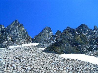
Trip: Sloan Peak - Corkscrew Date: 7/7/2007 Trip Report: Not a lot of traffic on this route recently, but 7,835' Sloan is good-to-go via the corkscrew. This details a July 7, 2007 dayhike that consumed 6.5 hours up and 3.5 hours down over the approximately 6 miles & 6000' (one way) distance/elevation gain. With the Mountain Loop highway still closed over Barlow Pass it's going to take a couple of hours from Seattle to get to the trailhead via Darrington, traveling south on the Mountain Loop about 17 miles to Forest Service Road 49. FS 49 is just a little rough in places but easily open to cars to the bridge just before the #648 Sloan Peak trailhead (maybe 3.5 miles in at an elevation of 1900 ft.) Mike Stuckey talks a bit about the road in his 7/4/2007 Glacier Peak trip report. I also climbed Sloan on July 4th and when I got to the "Road Closed" sign at the Lost Creek bridge early that day it blocked off the entire road. When I came out that evening, however, part of the barricade was moved out of the way and it was obvious that there was traffic going up and down the road. If I were to park at the bridge like Mike did and not risk it I would seriously consider bringing my mountain bike along to cover the 2.5 miles to the N. Sauk trailhead. On the other hand, if you are going up the Sloan Peak trail it is just around the bend past the bridge. The Sloan Peak Trail #648 is still that same obnoxious, overgrown, washed out, downed-log mess that it has been for years. However, it is presently well-flagged and fairly obvious across the 3 minor tributary crossings to the final North Fork Sauk river crossing where a massive log jam at the final crossing has created a much deeper channel than there used to be. This would be a really tough crossing were it not for a solid new fallen-tree just upstream from the old gravel bar crossing. During my recent trips up there I cleared the trail a little, flagged a little, and cut roots off the new tree crossing to make it a little easier to navigate. It's time to rewrite the guide books because the log crossing is back in. Once on the far side of the North Fork Sauk the route heads upstream hugging the bank to the start of the old forest trail. Once on the trail, it continues to run along the river for a bit before heading uphill to intersect an old logging road, and then head uphill some more. The way is fairly well flagged. Once in the forest you face about 4 miles of steady uphill to get to the upper meadows on old, unmaintained #648 through fallen logs, brush, avalanche debris, and a number of water crossings. The way remains fairly obvious all the way to the camp area at the start of the heather meadows. After about an hour on the trail you arrive at the awesome Cougar Falls crossing, which can be a destination in itself this time of year with all the high-water snowmelt. It's good to consider that this may be a difficult crossing in the late afternoon as the river rises - I left a rope-assist which was comforting to have on the way out. Just past the falls I hacked out a direct uphill bypass to get around a significant new treefall area. That's the only new obstacle on the trail, as if you needed any more, and the old avalanche crossing higher up has actually become an established trail. As you break out into open meadows (~4,500') there is continuous snow this time of year and the use-trail to the upper ridge is not obvious. It helps to have a clear idea of where to go but if in doubt, simply heading up works. Figure on an hour from the meadow camp to attain the ridge (and some nice bivy sites) at the glacier's edge, and then another couple of hours to cross the glacier and climb the peak. I headed directly uphill on snow from the large flat rock with a cairn on it in the camp area to eventually attain the ridge-top at the edge of the Sloan Glacier which lies beneath the very distinctive long rock wall of Sloan Peak. The summit block is not obvious from this side, but as you wind around the corkscrew it is revealed. Here's a shot of the summit block from the upper corkscrew: Crossing the glacier was so straightforward - just a slushy uphill snow slog, angling up and across towards the rock wall with axe in hand but no crampons needed at this time. Right now there are no open crevasses but caution is warranted since they are there, waiting. The final portion of the glacier traverse runs fairly close the the rock wall with some nice northerly exposure as the glacier rolls steeply out of sight below you. Here's a shot of the basic route ascending up the lower portion of the Sloan Glacier: There is currently no moat at the far side where the goat trail begins, but there are lingering snow banks along this upwardly corkscrewing route and also in the gully that leads towards the summit. These, however, are easily bypassed with standard class 3-4 scrambling. The summit experience on a clear day is quite fantastic with peaks surrounding you both near and far, 360 degrees. For me, this is one of the finer summits to stand on in all of the Cascades. There are a couple of summit register tubes up there, both filled with loose scraps of damp maps & paper. If you're headed that way, taking along a new Mountaineer's logbook register would be a great idea. Glacier Peak is just one of the hundreds of familiar peaks you will see: Gear Notes: Axe, helmet Approach Notes: Darrington, Mountain Loop, FS 49, Sloan Peak Trail #648, Sloan Glacier, Corkscrew
-
if you didn't see God it doesn't count
-
I've got one other pic that may help - if you swing the camera just to the right of my photo of that steep, nasty-looking notch you see the easy way I went. The easy notch I passed through is just on the other side of the big block in the picture below - given a choice at that vantage point the way of least effort is obvious. Once through the notch you move downward and left to get onto a narrow ledge with over hangs that make you want to crawl in a few places - that's the distinguishing characteristic of that ledge and Tom would remember that if he did go that way. Note that Beckey's description, cited in your text, clearly talks about moving "right" from the notch access point, which would put you on the wrong block of rock if you went up that nasty gully. Well, the nasty little gully may in fact go (it would be tough) but nobody has written a description for it. Randy
-
[TR] Granite Peak, Montana- East Ridge (via Huckle
BlackHawk replied to summitseeker's topic in Montana
Nice! I've heard so many stories about people getting caught in serious storms all along the continental divide, but in all my trips to the Rockies I have had nothing but good weather while actually on the trail. That includes the month I spent in June/July 2002 (a very dry summer) driving along the divide from border to border climbing various things and living out of the back of a 4X4 pickup when I wasn't on the trail. Montana was the highlight of the 2002 trip and I climbed Granite in early July. The drive approach I took to the Absaroka-Beartooth Wilderness was via Yellowstone National Park and the incredible Beartooth highway that winds its way up to 10K' and then eases back down into the town of Red Lodge, Montana. I took the West Rosebud Creek Road near Fishtail to reach the trailhead and then hiked the 10 miles and 5,500' up to an incredible 12,000' bivy site overlooking the 12,799' Granite summit at the end of the barren Froze-to-Death Plateau. There were, indeed, a large number of mountain goats up there. There isn't really a trail up that Plateau - just an infrequent series of rock cairns and the weather was so nice it was more like the Fried-to-Death Plateau. I couldn't believe there was no one else up there. From the end of the Plateau the standard climbing route drops about a thousand feet to that saddle you mention and from there heads up maybe 800' (mostly snow at that time) to a narrow notch at the ridge crest apex. Just through that notch you contour down to the right and arrive at that airy snow bridge. When I faced it, it was an untrodden icy knife-edge but hacking out steps turned out to be a simple matter of breaking through a 3 inch crust to stable snow below. While doing this I spotted an ice axe in the rocks way down at the bottom of one of the runouts, which provided an adrenaline rush imagining the possibilites - I still remember all this so clearly. I also remember arriving in that summit block amphitheater and taking some time to consider the rock-climbing puzzle that lay ahead. Great rock and not really that difficult if you have a little time for experimentation. I sat on that big flat rock at the top for over an hour in clear, warm, windless conditions. This is a highly recommended trip and remains one of my best summit experiences anywhere - class 4 max and I climbed and downclimbed the route with no aids or problems. All I needed was the crampons and axe in a few places, particularly that snow bridge. I was planning on spending another night at base camp but got down early enough that I decided to pack it up, hike out, and head down the road to the next one. I met several other groups coming up as I went down and was amazed again that I had that awesome place all to my self for a few days. Randy -
Below is a closeup of that Storm King notch that has an arrow pointing at it in the Stepenson/Bongiovanni Summit Routes book. The summit block is the rock rising up to the left and none of the route suggestions I've read describe going up this nasty little gully. Tom, you went the same way that I went, heading up to the right from where this picture was taken to an easy notch. It's the way Goldman recommends in her Washington's Highest Mountains book. I passed through that notch and headed left on a ledge, passing back on the other side of the notch pictured here via class 3/4 rock, and headed up to the summit from the far side. Blake, you went up the way Beckey talks about which leads up into the notch on the left side of the summit block (to the left of where this picture was taken) between the east/west peaks. I saw the rap slings you used to drop back down and would have done the same but I didn't bring the rope on this particular outing. Going your way, you angle right onto summit block rock before you get to the notch. As you point out the Beckey route description could be a little better and nothing changed for Storm King in the 2003 (green) revision. Scott, I'll post a report on your summitroutes.com site. Randy
-
Blake, did you go up the big V notch, straight up and across the snow, in this picture (check the attachment)? From the summit I saw rap slings leading down in to that notch, but on page 61 of the Stepenson/Bongiovanni book an arrow is pointing directly at the small V notch - next one to the right (there's a little finger sticking up in it). I was thinking no freaking way and went even further right, to a notch on the right of that furthest spire back - this may have been easier than the route you (and Beckey) describe. Your description is good, but it all hinges on getting the correct SW orientation. Randy (edit info - annotated attachment picture below added 9/19/2005)
-
Climb: Thunder Slam: Storm King, Goode, Logan 8/19,20,21-Park Creek Date of Climb: 8/19/2005 Trip Report: Over August 19th, 20th, and 21st I climbed 8,515' Storm King, 9,200' Goode, and 9,087' Logan. The full moon roamed the night sky and I had the best of weather all around. While there I replaced the summit register on Logan with a new log that I picked up from the Mountaineers – Blake from the CC forum brought down the filled up register earlier. For me, Logan was the last of the ten non-volcanic 9K+ peaks in Washington to climb, and it was the perfect finale to that quest. I’ve been thinking about climbing Goode and Logan for some time and have been lamenting that I didn’t get around to them before the massive storm of October 2003 wiped out easy access. The most recent books covering North Cascades climbing (Stephenson’s Summit Routes: Washington's 100 Highest Peaks, 2005 and Goldman’s Washington’s Highest Mountains, 2004) don’t detail the ongoing difficulties you face just getting to the base camps but do promote the excellent notion of consolidating climbing efforts while you are in a particular area, from the perspective of knocking off the Bulger Top 100. Actually, my simple goal was merely to finish off Washington’s Top 15 (every peak over 9K, volcanoes included) but I decided to put Storm King (#50) on the list because of its great location in the nice line of peaks running up the North Fork Bridge Creek drainage. I found that all 3 of these peaks present roughly the same level of route finding and climbing challenge and that what Stephenson calls the Thunder Slam makes for an awesome outing. The basic idea is to climb 3 big rocks in about 5 days, gaining maybe 14,000 feet in elevation in the process. Attempting this begins with a consideration of the 4 main 20-or-so mile approaches (Cascade Pass, Thunder Creek, Bridge Creek, Stehekin) to the Park Creek Pass area. In order to stay within a good weather window I planned a 5-day trip that allowed one day each for the approach and retreat. Since I wanted to be climbing on the second day, and armed with good beta from Blake, I figured the best one day approach for me would be to drive to Chelan, take the ferry to Stehekin, mountain bike up to the Park Creek trailhead, and then hike on up the Park Creek drainage. I brought along my mountain bike and found that biking up the 9 mile closed-road portion of this approach with a full pack worked fine, even when the road began to look more like single track. Arriving in Stehekin, I assembled my things at the landing and then headed up to the Golden West Visitor Center to grab a National Park backcountry permit. I’m not in tune with all the goings-on in the village of Stehekin but it did seem to me that this place is not geared towards those who actually do things in the out-of-doors. I was the only climber currently registered in the backcountry book and, looking around, I didn’t see anyone who seemed particularly capable of finding me, even if I told them exactly where to look. They asked a lot of questions like they knew what they wuz talking bout, but the give away was the overt use of mnemonics to identify the 3 main peaks off in the distance – “I went to Boston to buy a Book for a Buck” and I can’t say they knew which was which. I let them know who to call if I wasn’t back by the end of the 6th day and headed back to the landing where, in the interest of conserving a little time and energy, I paid the Indiana Jones wannabe shuttle bus driver $9 for the 9 mile lift up the valley to where my 9 mile biking exercise would begin. Along the way I realized that I was probably the only one around who didn’t know Stehekin had a bakery - a fine bakery in fact. Actually, I’ve gone out of my way to avoid Stehekin in the past, but all this was soon forgotten as I made my way up the valley and in a matter of hours I was at the Park Creek trailhead where I stowed the bike and headed up the trail to Two Mile where I camped by the river for a comfortable, bug-free first night out. Early the next morning I crossed the river and was back on the trail heading up the valley, soon arriving at the enormous washout running down off the SW face of Goode. Just after reentering the woods on the far side of the wash I spotted the 10’ snag and small cairn marking the start of the steep Goode climbers trail. I stowed some food and unneeded gear in the woods and headed up through forest and brush, eventually intersecting the well-established climbers track on the ridgeline and moved on up through forest, grassy meadow, and finally Western Larch laced cliff bands to an excellent 7,400’ bench near the foot of Goode’s SW face where I set up camp and prepared to climb Storm King. From the 7,400’ campsite it is a relatively level mile-or-so of northerly traversing around shoulders, across benches, and over talus and lingering snow to reach the scree-and-talus run-out coming directly down from the spires of Storm King Mountain. I turned and worked my way up that slope and eventually moved right and up onto a rocky buttress for easier progress. I paused to review route descriptions and realized that Stephenson/Beckey and Goldman describe two different climb approaches for Storm King and it looked to me like the Lowell Skoog photo in Stepenson’s book has the arrow pointing at the wrong notch. I think the correct notch is actually further left, per Beckey, around to the left of the peak and not visible in the picture in the book. I didn’t bother to check it out because I was already headed up Goldman’s route that leads up through blocky boulders to an easy notch at the natural finale of the scree-and-talus slope, to the right of the twin-towers that rise up before you. Passing through that notch, I traveled left across a narrow ledge system, around one ridge and over to another beneath the summit, and then worked the route up from there, paying attention and staying on class 4 rock to the top. I had great afternoon views in every direction but the look over to Goode, which I would be climbing the next day, was the real knockout. I quickly down-climbed the route and got back to camp about 3.5 hours after starting out with plenty of daylight left to cook dinner, relax watching the sun set, and contemplate the next day’s climb. Waking up several times throughout the night I watched the moon in stop-frame progression as it moved across its horizon-spanning arc and finished off my breakfast tea as it hung low in the west over Johannesburg and the night sky shifted from purple to pink. From camp the slog up to Goode’s SW Couloir was a tedious exercise in scree-and-talus negotiation, heading easterly up along moraine slopes towards a ridgeline at the head of the SW face cirque. As the length of the SW Couloir came into view so too did the ledges that provide easy access to the couloir. Ascending the couloir was very straightforward but about 3/4 the way up there is a more challenging rounded slab with sparse hand/foot holds that may slow you down. At the top of it, after a few class 5 vertical movements, I found a block with multiple rappel slings and a ledge that I followed to the right. At its end I headed up an angling gully to the flat-rock notch on the SE ridge of Goode, at the top of the SW couloir, known as the Black Tooth notch. From the notch I worked a ledge downward and left on over to an obvious ridge of the notorious NE Buttress, gaining it near a bivy site right on the ridge where I doubt anyone intentionally bivouacs. From there it’s the typical Cascade climbing exercise. If you pay attention it’s all class 4 movements up ramps/gullies and across ledges to reach the top. I zigzagged upwards some distance across the buttress and then headed straight up a blocky ridgeline adjacent to one of the few remaining snow fingers running down from the summit. Once again I had simply killer views in all directions, but the look directly down the NE Buttress to the Goode Glacier far below will take your breath away and made me want to do the entire route. I down-climbed the way I came up until I reached the one little difficulty in the couloir where I set up a rope on the existing slings and rapped down to its end just to justify having hauled it all the way up there. From camp this was about a 4 hour summit round-trip, which left plenty of daylight to break camp, head back down to the Park Creek trail, exchange and stow gear near the 5 Mile camp. I exchanged greetings with a backpacker who was setting up camp, one of the few people I met anywhere along the trail, and then headed up to the Park Creek Pass vicinity to camp and prepare for the next day’s climb of Logan and the hike out. That night I set up camp near another campsite, but the occupant of the bivy bag was nowhere to be seen as the day’s light faded. This was cause for some concern, but I suspected that someone would eventually drag their weary butt into camp by headlamp after a long day out climbing or something and got organized for the next day’s glacier traverse up to Logan and slid into my bivy for the night. Shortly after dawn the next morning, as I departed for Logan, I noticed that the other campsite was still not occupied. This was definitely not good. The sun had not yet risen over the distant ridge as I headed up the climbers trail from a switchback a short way down the Thunder Creek side of Park Creek Pass. As Beckey says, the SW route to Logan has some flexibility. Rather than stay on the sketchy climbers track heading northerly at 6,200-6,400 feet towards the basin beneath the Fremont Glacier, I moved upwards through open Western Larch towards the large rock outcropping of the South Peak and crossed over it at about 7,200’, dropping down into the basin beneath Logan via a loose rock gully and then worked upwards to reach an awesome 8,000’ bivy site next to a large boulder at the southwestern end of the Fremont Glacier. I headed across easy hard snow and glacier ice with crampons and axe, passing between Point 8248 and the Middle Peak, and then headed steeply up through an icy and crevassed portion of the Fremont where I found ways around difficulties - nothing major. I headed to the left of the huge wind cirque in the glacier and followed an icy ridgeline to the edge of the cliff where the rock climb begins. The glacier overhung a deep moat and I planted my axe for protection as I leaned across the moat and stepped down onto a small ledge. This first section seemed to be 4th class, but the rest was mostly class 3 scrambling, northerly along and below the far side of the ridge to a final more vertical push from a shoulder just beneath the summit spire – all very enjoyable. I doubt there is there a better mountain anywhere in Washington for such long views of so many familiar high peaks, massive glaciers, and deep valleys. The weather was perfect, and I took my time heading back down after transferring names to the new summit log and adding my own. As I neared Park Creek Pass I ran into another climber who planned to climb Logan the next day. I asked him if he had seen the vacant bivy on his way up, and I was relieved to hear it was his. Turns out, he had climbed Storm King the day I climbed Goode and attempted Beckey’s high traverse to Park Creek Pass on the return. He ran into serious difficulties and then ran out of daylight and wound up bushwhacking down to Park Creek where he stumbled into the 5 Mile camp exhausted and unable to continue – Blake reported difficulties attempting this too. The backpacker I talked to while stowing my gear had shared his camp with him for the night – awesome! So, 6 hours after I had started out I wished him luck and headed back to the campsite, packed up, hiked the 8 miles down to the old road, and then biked a few more to the Bridge Creek campground where I camped in relative luxury with a picnic table next to a clear (no silt) running stream. The next morning I rode the 16 remaining miles back to the Stehekin landing, checked out with the ranger, caught the ferry back to Chelan, and made my way back to Seattle. Gear Notes: Rope, helmet, crampons, axe Approach Notes: Park Creek via Stehekin
-
Dude, grab a clue! What on earth makes you think you're not playing a part in the history of the evolution of sports in the Cascades? 200 years from now, when there are no longer any glaciers in the Cascades and the forests have burned away, some miserable grad student will get a good laugh uncovering data on the topic. Climbing registers from the early 2000's, along with the ancient archives of this very forum, will clearly reveal things like what the climbing season once was, what people used to consider real wilderness to be, what obsolete climbing techniques were once deemed necessary, what used to be considered really hard and, last but not least, what the social life of climbers and their dates was once like early on in human evolution.
-
Park Creek Pass access (Goode, Logan, Storm King)
BlackHawk replied to BlackHawk's topic in North Cascades
Nice TR, Blake. I plan to spend about a week in the area this month and hope to find the same kind of weather window you had in July. I can take a summit register back to Logan if needed - so do the Mountaineers actually have an "official" replacement at the bookstore. The common spiral notebook seems to be working. I will contact you for biking info.