kuhar
-
Posts
8 -
Joined
-
Last visited
-
Days Won
1
kuhar's Achievements
")
Gumby (1/14)
5
Reputation
-
Aw man! Seems like timing just didn't work out to hear back before we left and like you were feeling more courageous than we were as I retrace the line in your photo. Thanks for responding nonetheless!
-
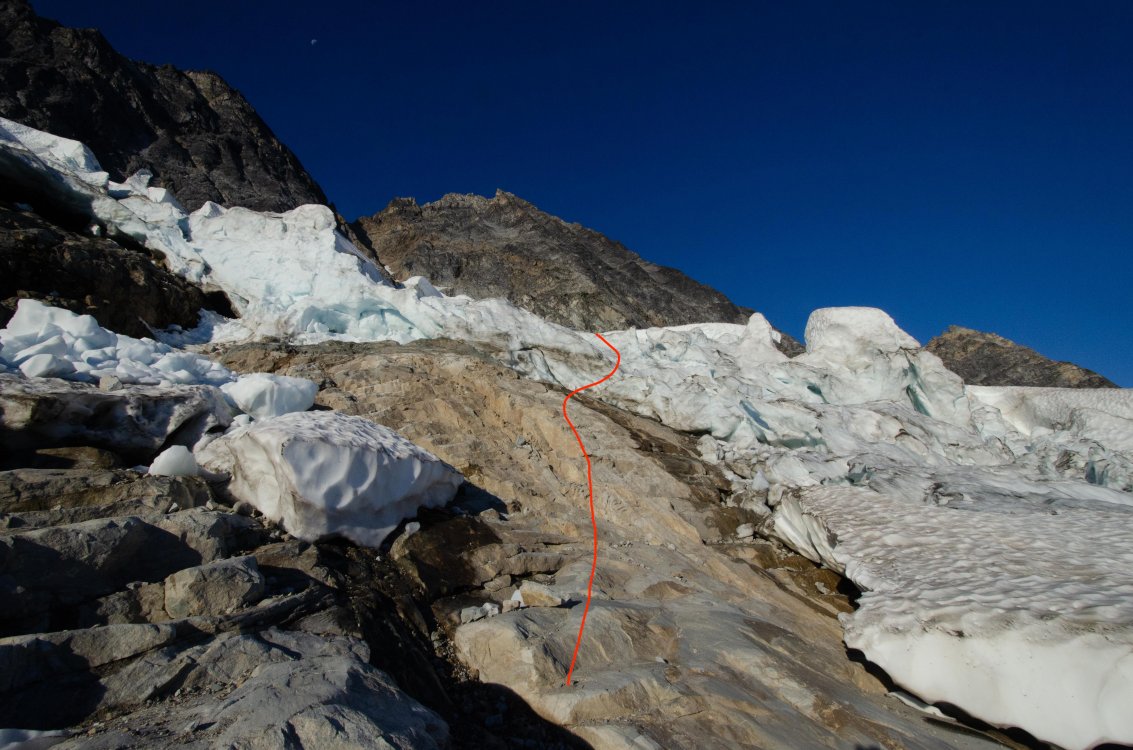
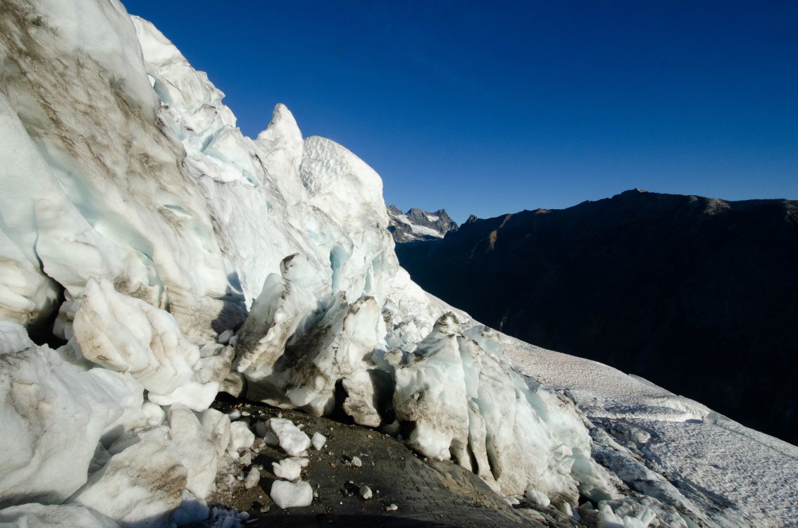
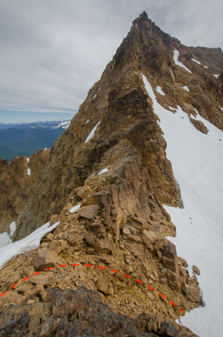
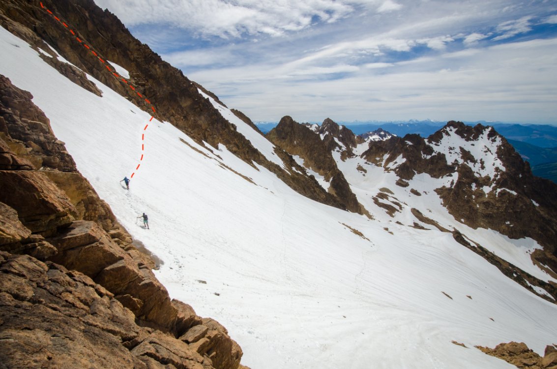
So if you don't go you won't know, right? We ultimately took our climbing gear for a long, but pretty, walk. We didn't have the chance to even evaluate the moat because getting onto the glacier to begin with looked impossible with our gear (boots, single ice axes, crampons, 1 picket, light climbing rig) with serious-looking crevasse hazard following. To be clear, about 10-15ft of 80 degree glacier snow/ice (see second photo). We followed the approach descriptions from available Beckey, Kearney, and Abegg and even found cairns marking the way. If anyone else has some suggestions or, yes, even thoughtful criticism then I'm all ears. However, this route seems out (at least for our comfort level) for the remainder for the season. We were up there with one other group who had heard in advance that two other parties in the week prior had also been turned around. She's a beaut though :-) Photo 1 looking at presumed glacier access point (line of intent marked in red): Photo 2 taken from toe of glacier at end of previous red line (we did not stay here long b/c safety):
-
Anyone been up the NE buttress recently who can comment on the condition of the glacier? Mostly interested in the moat situation to get onto the ridge.
-
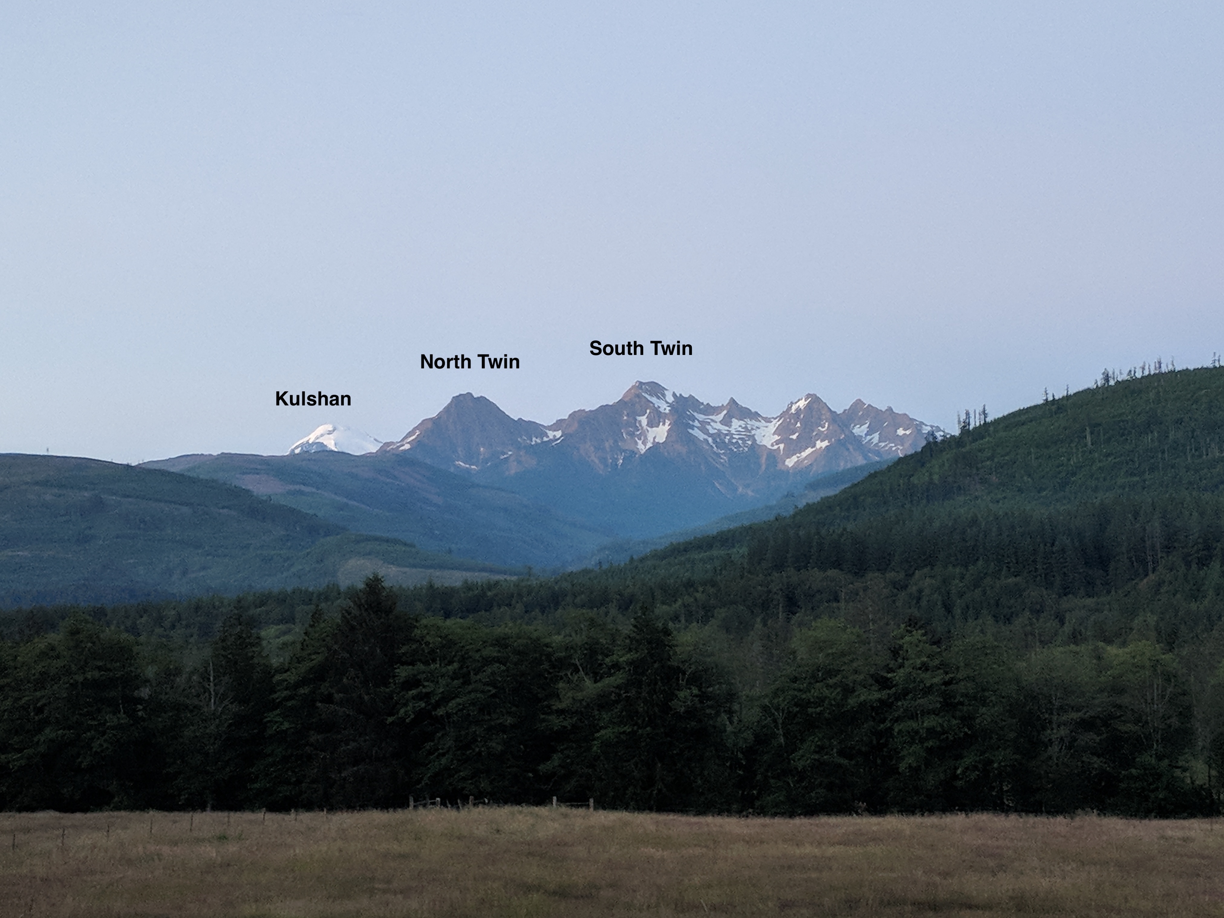
[TR] Twin Sisters - Twin Sisters Traverse 08/27/2018
kuhar replied to R. Forbes's topic in North Cascades
Hey nice work, dude! I'm psyched you tried that descent off the NE ridge of S twin and that it went so easily. If we get more people to try that route on the N twin I'm sure it'll firm up more, right?- 1 reply
-
- 1
-

-
- twin sisters
- north twin
- (and 2 more)
-
Water situation at the Bench Camp below Burgundy Col in WA pass
kuhar replied to YocumRidge's topic in North Cascades
Was up there this weekend and was curious about it too. It's running just great! -
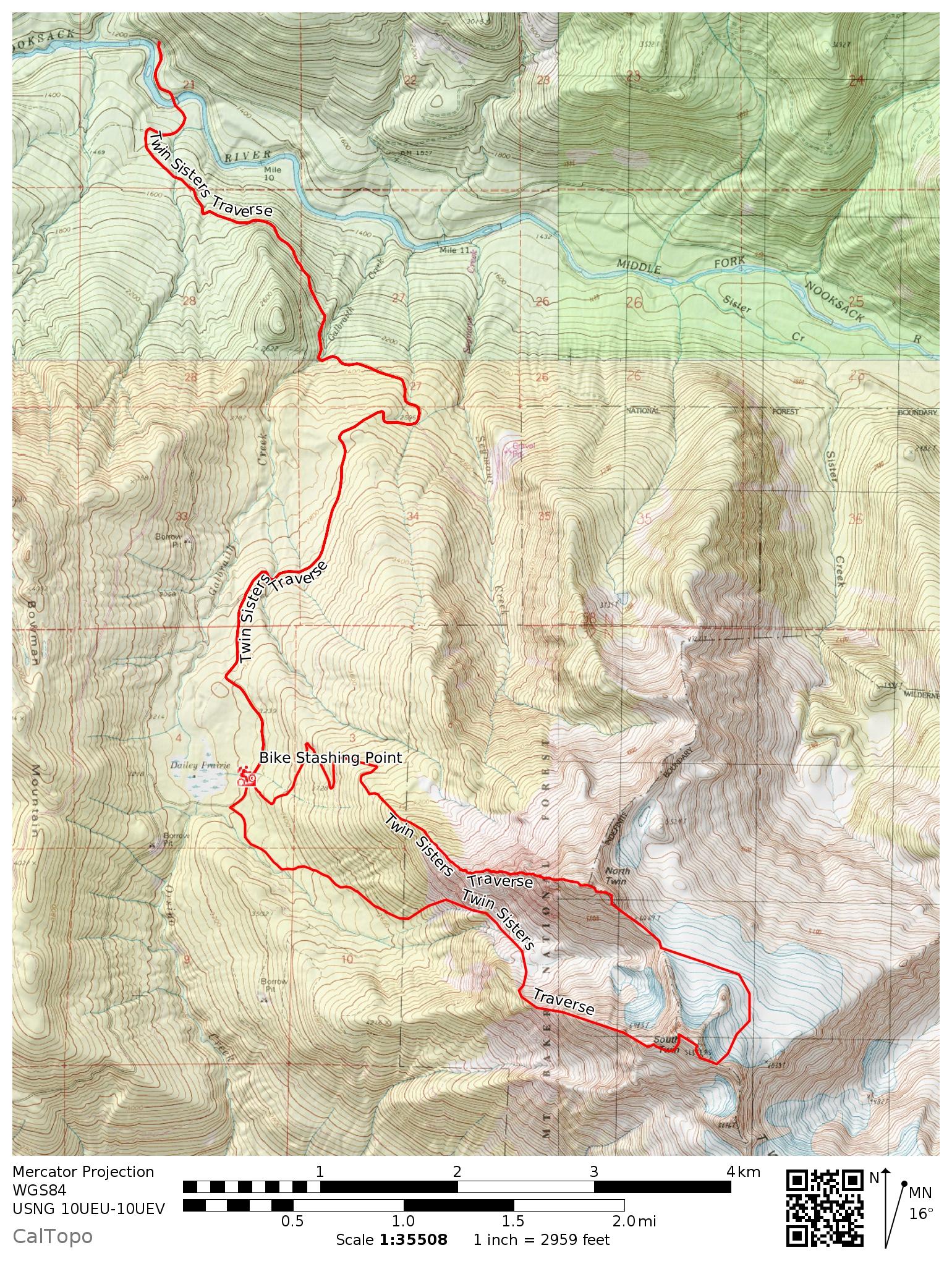
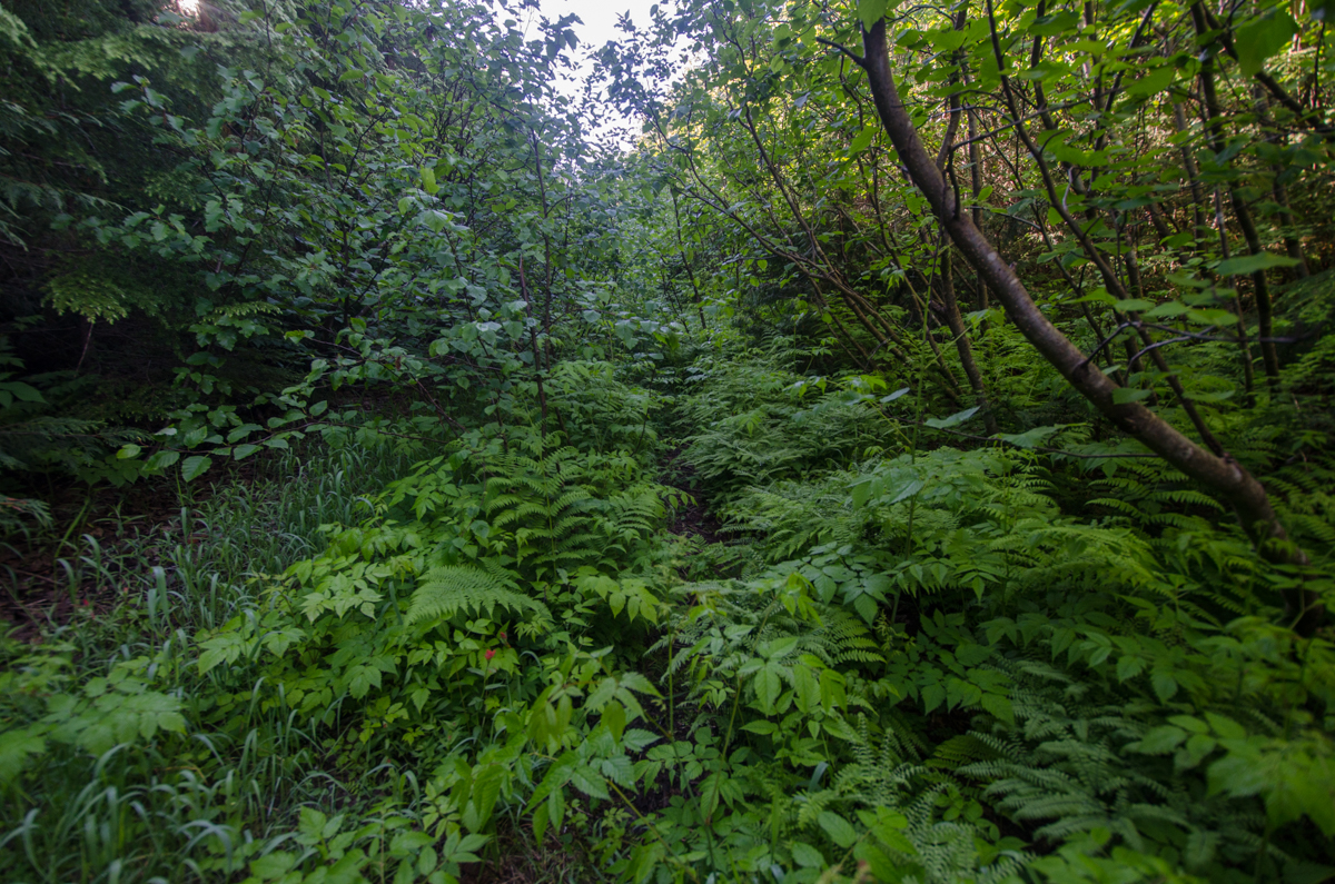
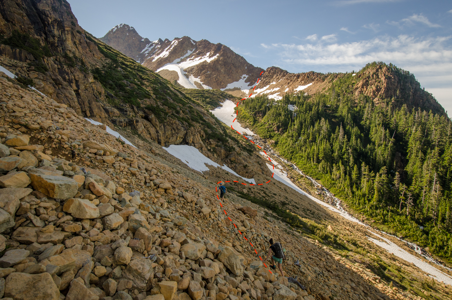
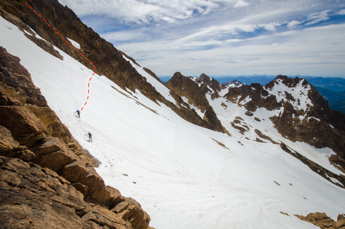
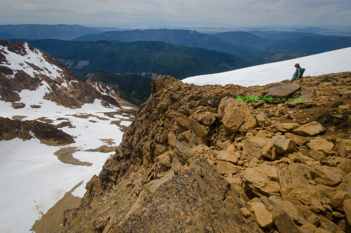
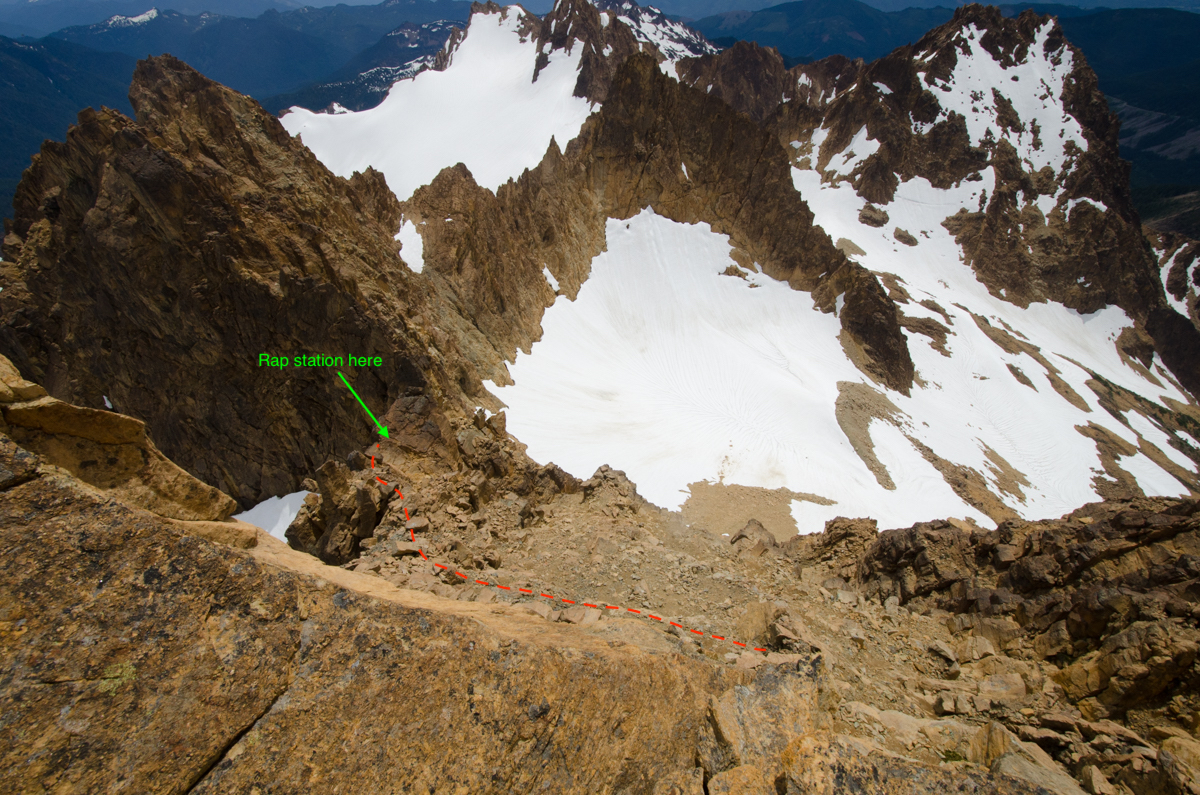
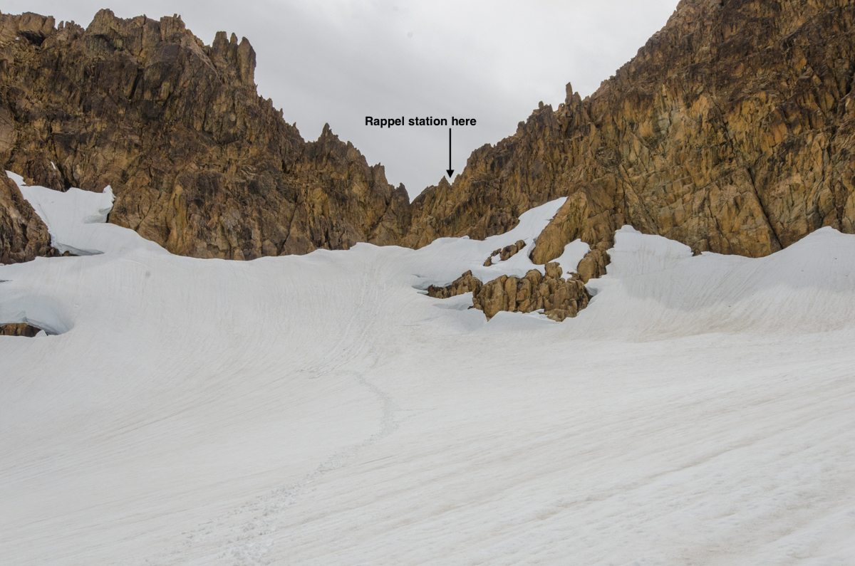
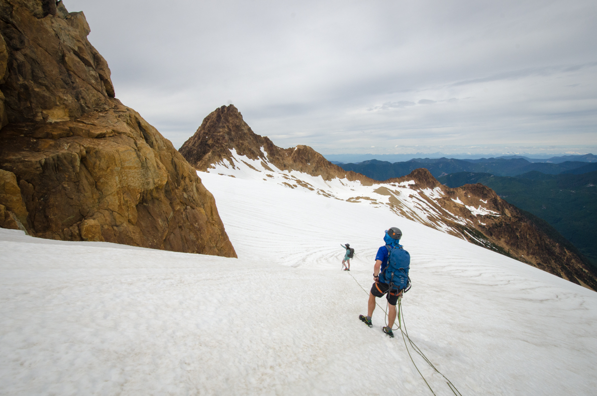
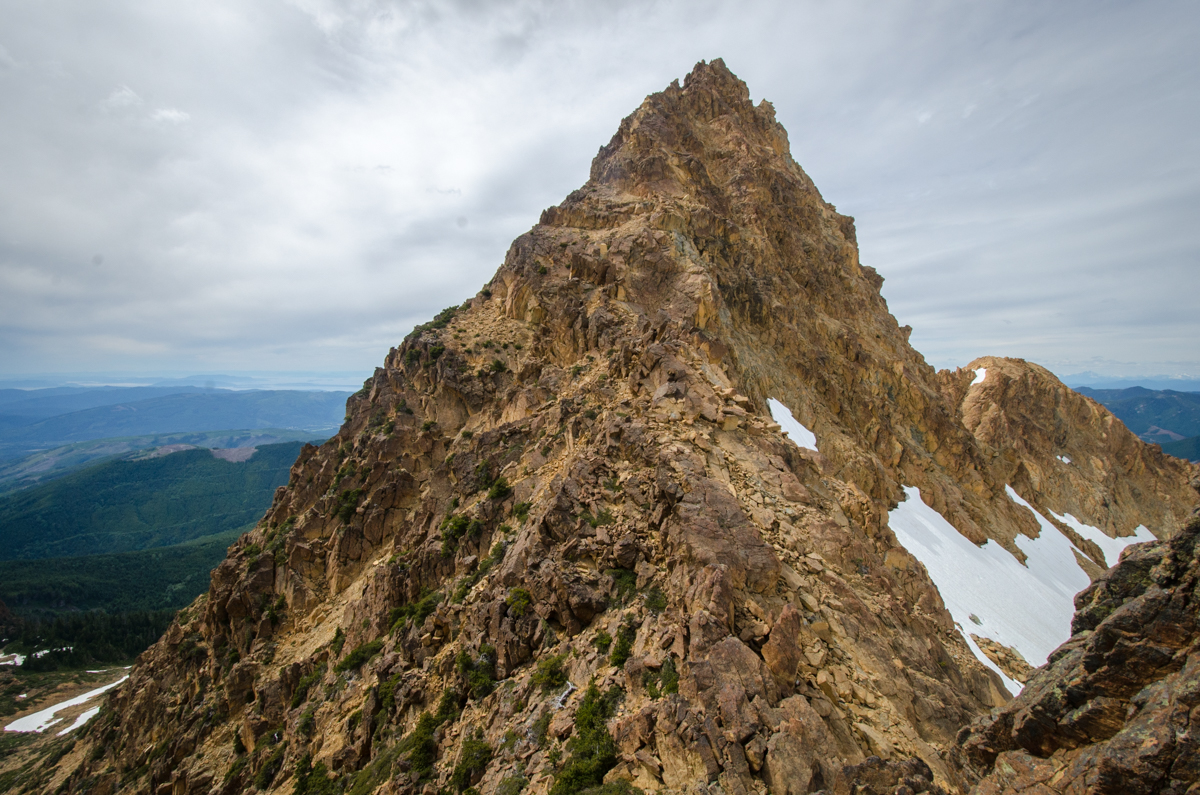
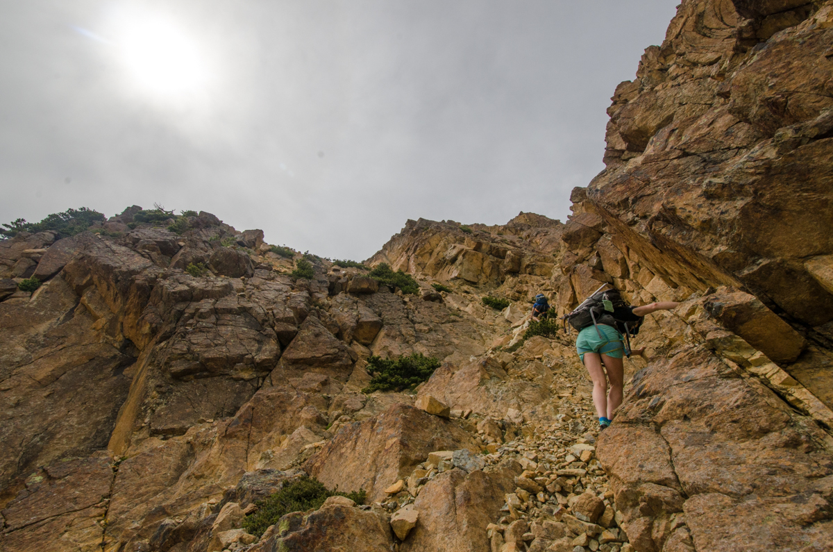
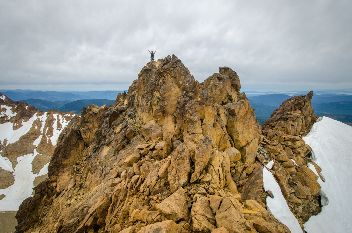
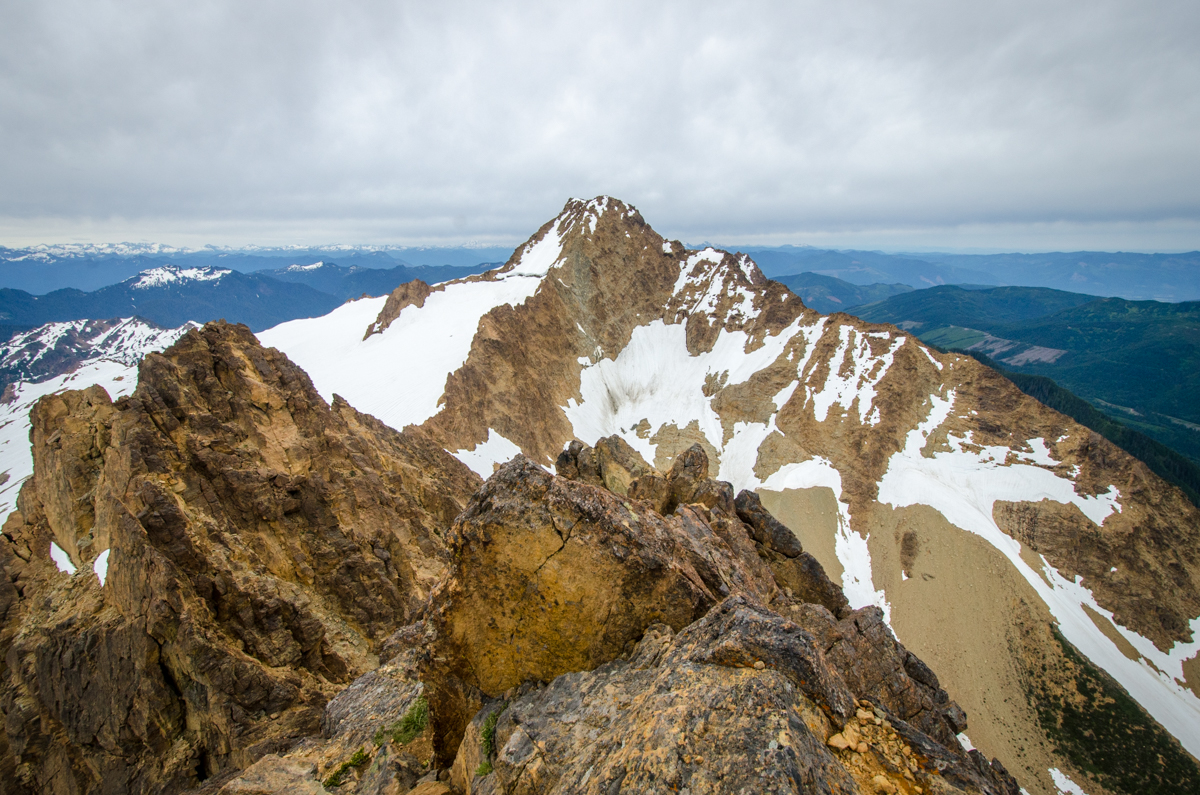
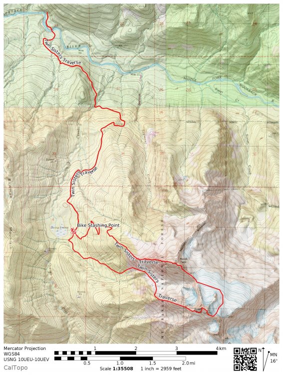
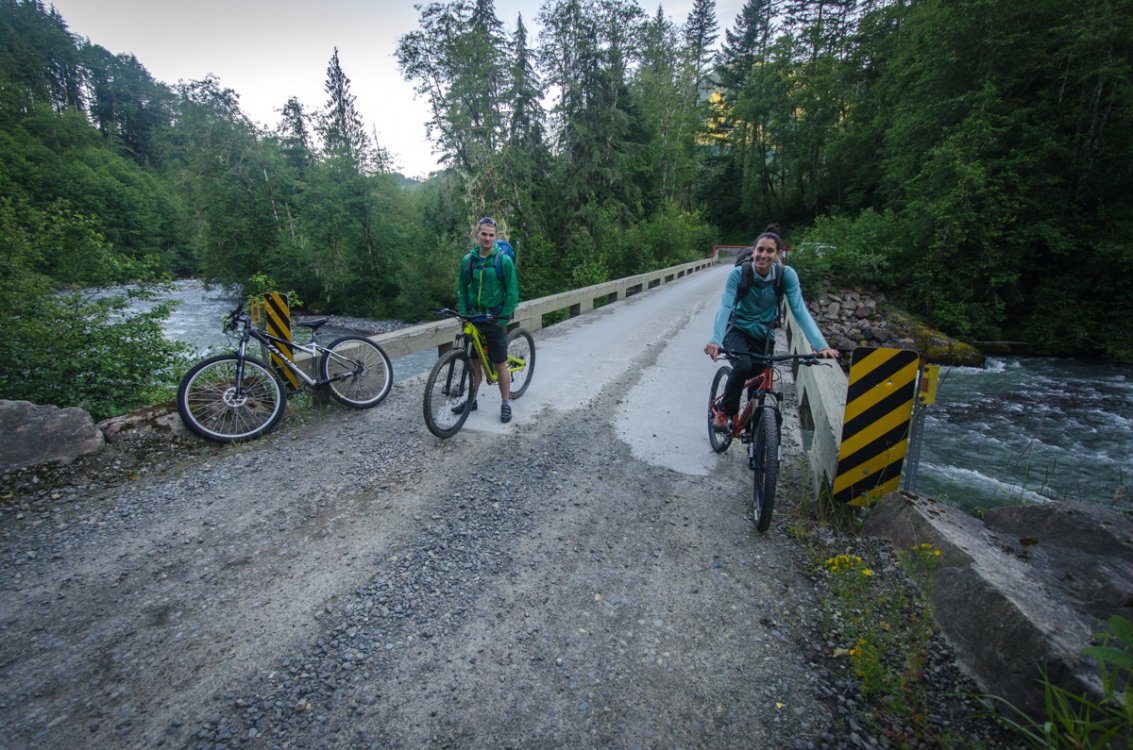
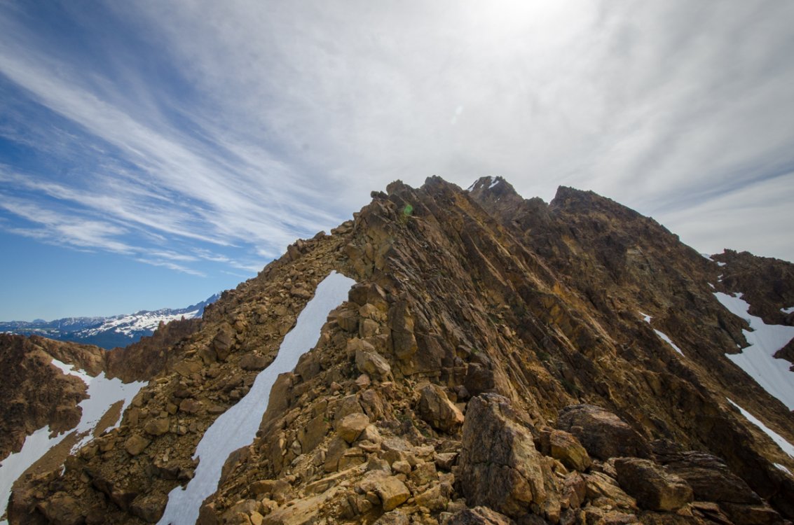
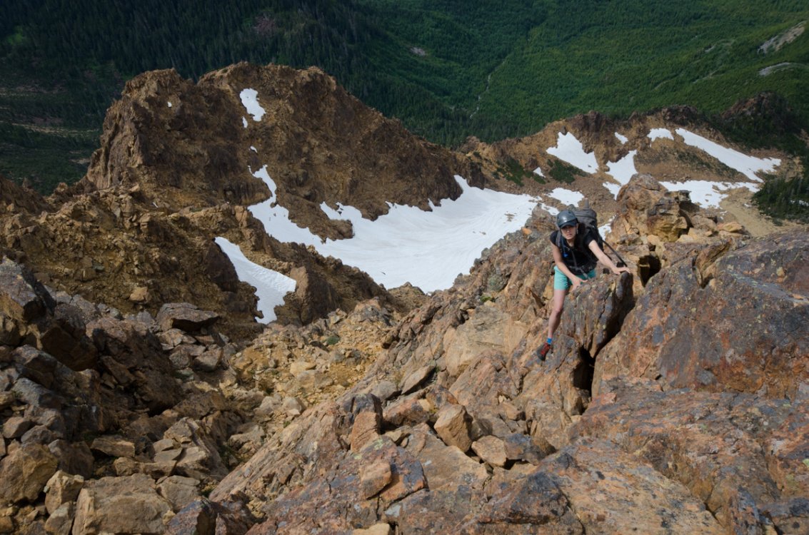
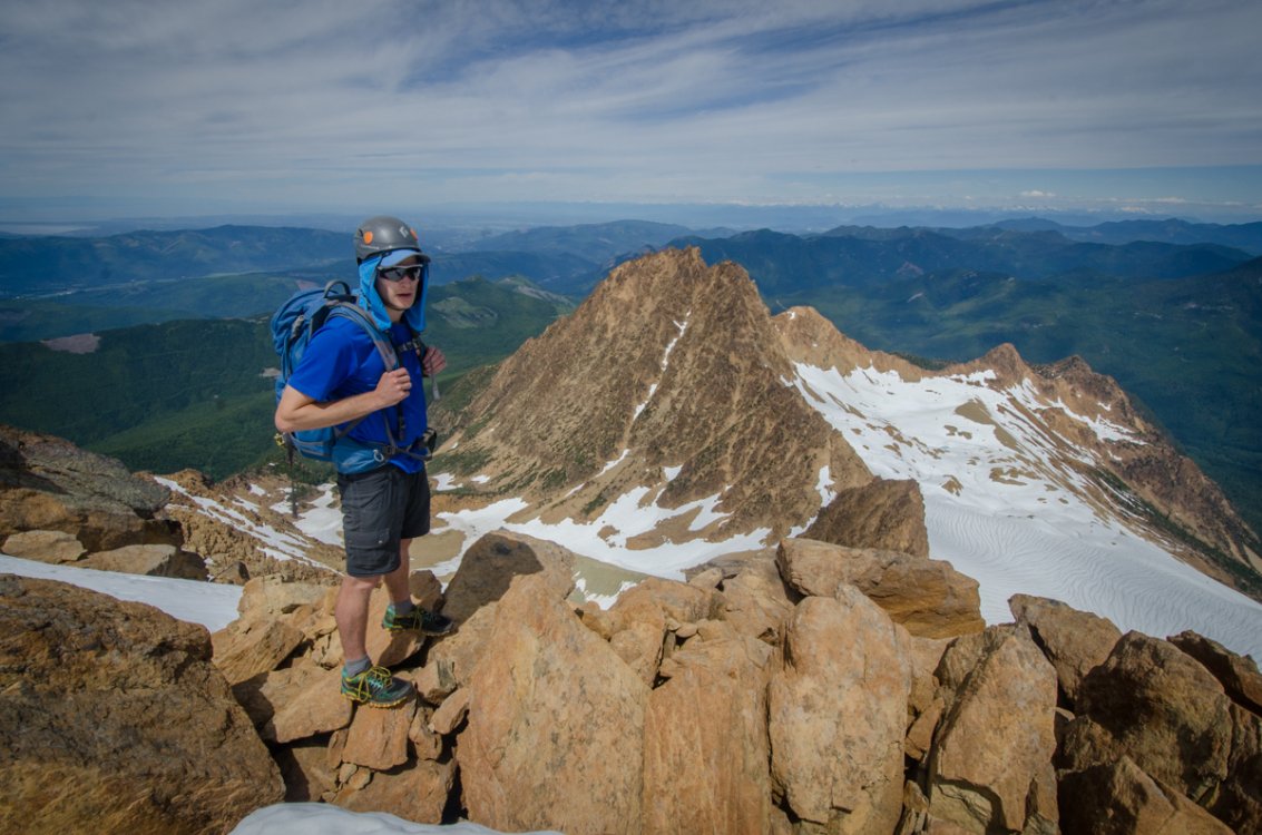
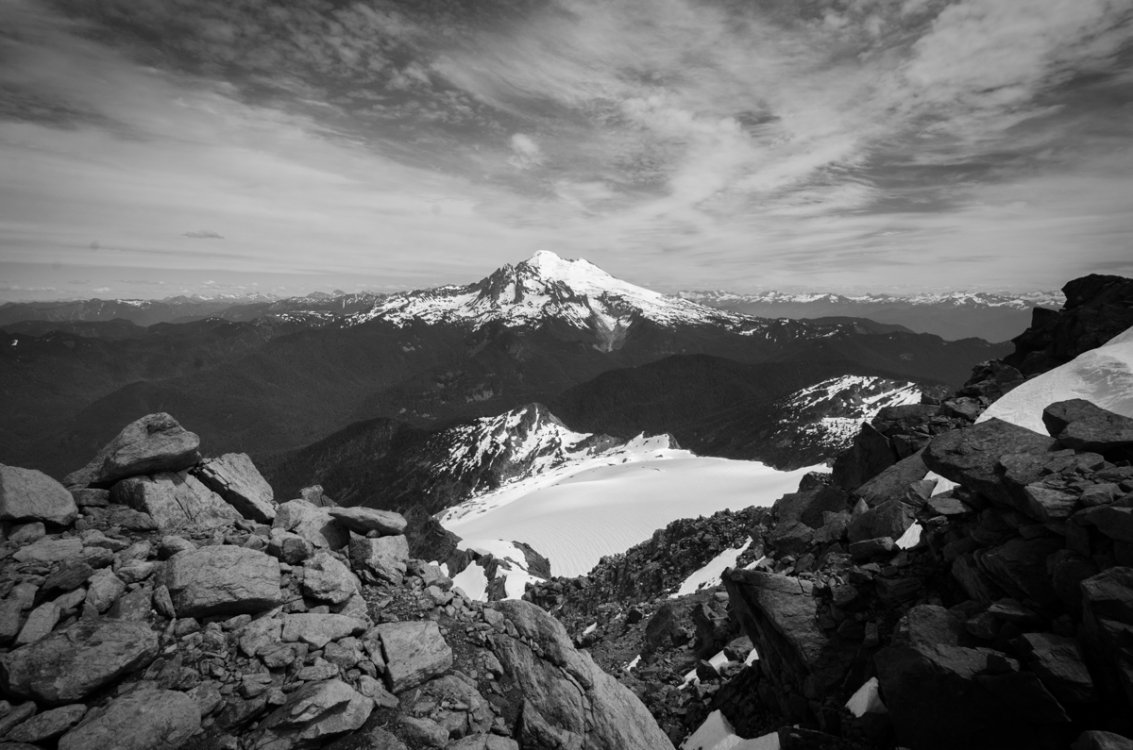
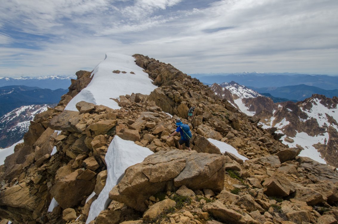
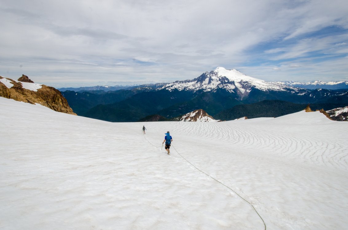
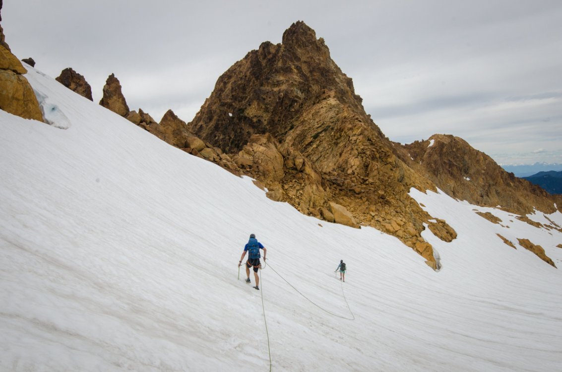
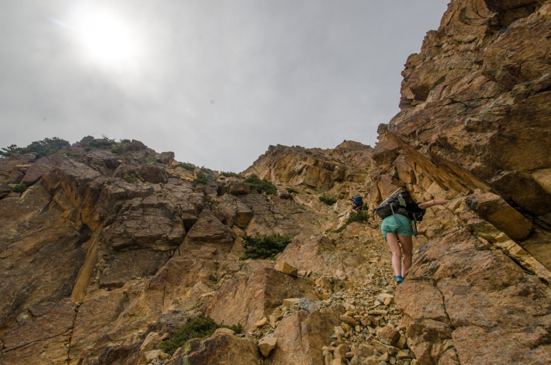
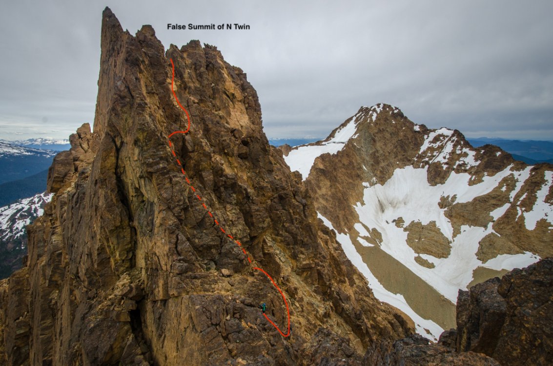
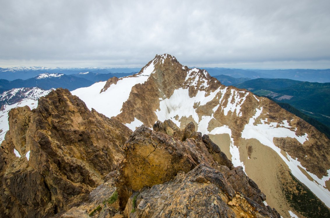
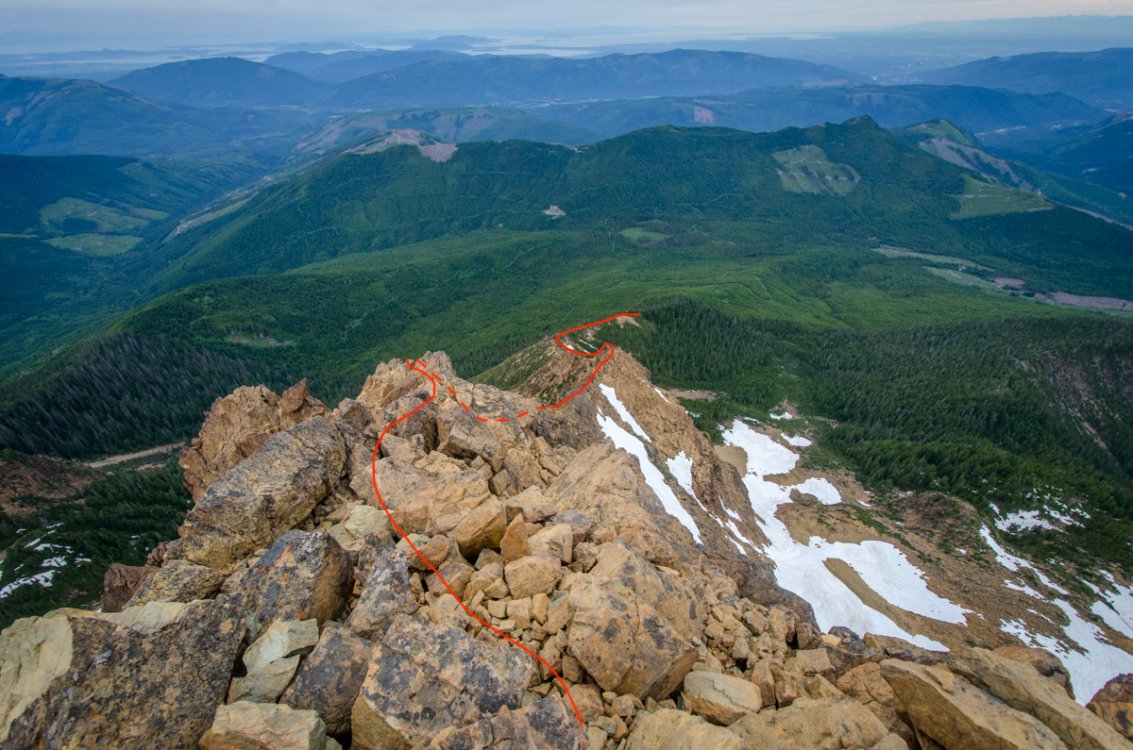
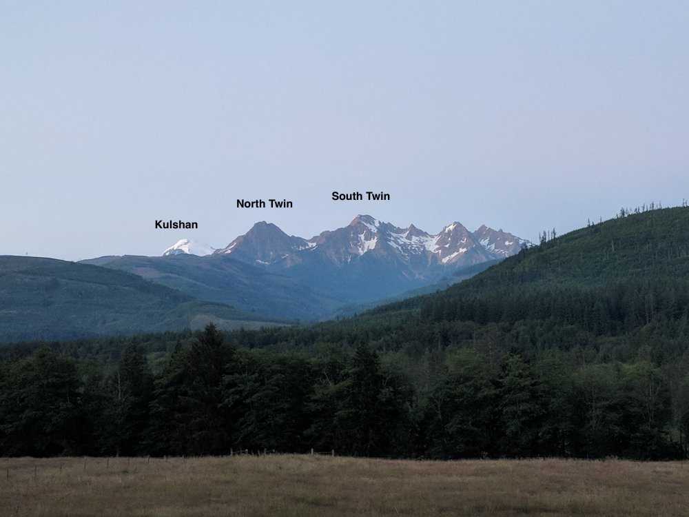
Trip: Twin Sisters Range - Twin Sisters Traverse Trip Date: 07/04/2018 Trip Report: Hi friends, We traversed the Twin Sisters on the Fourth of July in 14.5 hrs. I have always been curious what this range offers as I've stared at it from Mt. Baker or other places in Skagit Valley. As a team of three we gave the route a go and had a great time out in the mountains exploring this new range. I'll write a few more details than the average TR as it seems like this route is not completed very often (judging by the poor quality of rap tat [now replaced] we found) and maybe could use some specifics and pictures (since I lugged a DSLR along the route). By the numbers: Linear distance: 17.2 mi Vertical gain: 6,536 ft Our route combined the following (for reference, see Beckey Guide 3: Rainy Pass to Frasier River pp. 40-45): TH on Middle Fork Nooksack River Rd. 38 (Beckey Guide 3 p. 395) South Twin ascent via the W. Ridge (II-III; mostly class 3-4, upper segment is low 5th) North Twin ascent via the SE Ridge (II; low class 5) North Twin descent via the W. Ridge (II; class 3-4) Click here for topo Our gear: Mountain or cyclocross bike 70 m half rope (60 m would be the minimum) Approach shoes (Eg. guide tennies) Glacier harness Ice axe Micro-spikes Helmet Climbing gear for rappel, rap tat (you shouldn't need any now ;-)) and maybe a very limited set of pro (we didn't use any, but that was our comfort level) Getting to the TH is pretty straightforward. We camped at the bridge the night before so we could get an early start. In the morning we set off on our bikes for a 6 mile uphill ride (took us 1.5h) on the nice gravel/dirt road before stashing them at the start of the trail for the North Twin (our out for the day). Quick note here about our choice of going S to N: descending the W Ridge of the N Twin at the end of the day was very nice. It has the best quality rock and the trail out is way more established. It's a lot of ground to cover and knowing the end of the day was going to be straightforward was something we were thankful for after a day of feeling pretty out there. It's a quick walk further down the road to the start for the S. Twin. The trail is in pretty good shape, but the brush is thick for most of the first half. After about an hour we exited the forest and into a beautiful alpine valley in-between the twins. We gained the W ridge of S twin pretty far down through some climbing on snow and then easy rock. From here it's a mostly class 3-4 affair for about 2-3hrs to the summit. The route-finding was sometimes unclear although there are occasional well-placed cairns. We found ourselves on something like a trail just south of the crest for the lower half of the route and then stuck mostly to the crest itself for the upper half. Like all of the climbing of the day, we did not rope up. Getting started: Trail to S. Twin is easy to follow, but overgrown: Into the alpine to ascend the ridge of S Twin: The W Ridge of S Twin is long and like this most of the time: The summit of S. Twin was accessed by a short traverse of a snowfield south of the crest and then ascending the final SW flank. This was low class 5 in places, but always secure. From here we traversed over to the true (?) summit to the SE for a quick lunch before debating how best to make our way over to the N. Twin. Descending the N ridge of . Twin looked to be full of towers that would probably slow our progress. We also probably didn't have enough rap tat for all of that. Descending the NE aspect and out on the arm looked dicey, but probably could go for a team that is braver than we are. We finally decided on descending the SE ridge to a notch that is well-visible. There is lots of exposure and loose rock here. We put in a rappel station up high and then reinforced/replaced the one in the notch that drops down onto the glacier. A quick rappel, downclimb, and small glissade put us down onto the sisters glacier. This area is probably also possible to downclimb if you really wanted to go ropeless, but please be safe, you know? This is where you exit the ridge and then ascend the snowfield to the final climbing for the summit of S Twin: On the summit of S Twin: Rapping onto the glacier from further down the SE ridge toward a notch: Backside of the rappel onto the glacier: Traversing the glacier was probably the high point of the day: Fast moving over flat ground, minimal crevasse hazard, gorgeous views in a remote-feeling alpine setting that just reinforced that the N. Cascades are the proverbial shit. Getting back onto the rock for us could not have been easier. We aimed for a clear low point in the ridge connecting the twins. From here we unroped and weighed our options, choosing ultimately to go for the not-often-traveled SE ridge (FA in 2008 according to Beckey). Of note, we did observe a new-looking rappel station here that would be convenient for those choosing to descend back into the valley. The SE ridge was by far the most dirty and chossy section of the day with challenging route finding in places. I tried to assemble a few cairns along the way. If you have trouble dealing with uncertainty, this is going to be a great way for you to work through those issues... Closer to the top we were able to reach the false summit by transitioning onto the W aspect and ascending a small, loose gulley back to solid rock. From the false summit, we downclimbed an airy section below several towers into the head of a massive gulley before quickly making our way on rapidly improving rock quality to the true summit. Aiming for the notch to access the SE Ridge of N Twin: Eyeing the SE Ridge of N Twin (I can't even begin to draw a line): It mostly looks like this: Traversing between the false and true summit: From the other side: True Summit of N Twin: Looking back on the day from N Twin summit: From the true summit we downclimbed the entire W ridge of N Twin giggling at how good the rock quality was. It was a superb experience to be so exposed with such high quality rock and clear route finding. You literally just stick to the crest for most of the route. From the base of the route we blitzed down the excellent trail to the bikes and then onward to lightspeed for the 6 mi downhill bike ride. Descending W Ridge of N Twin: Thanks for reading! -Ryan Gear Notes: See TR Approach Notes: See TR


-
Hey, Just finished a Southern Picket Traverse. The glacier below Inspiration is really broken up, but probably passable. We traversed into it, but found another party ascending the gully, so I assume they came up that way. Just posted a TR with photos here: http://cascadeclimbers.com/forum/ubbthreads.php/topics/1141133#Post1141133
-
Trip: Southern Picket Range - S to N Ridge and Glacier Traverse Date: 7/2/2015 Trip Report: Hi Everyone, It's been three days since I've gotten back from this amazing trip and I'd like to take the time to write it up (my first post here) as it does not appear this area or route gets much attention. This will be a long and semi-detailed post, so take your time now to grab a beer or whatever... Before I begin, let me just say that the Picket Range is an incredible place to be. They are also about as wild as you can get in the lower 48. My advice for anyone planning a trip back there is to treat them with the respect they deserve. Do your planning; be conservative with your estimates and decisions; and don't cut corners. A mandatory site to visit is Steph Abegg's Picket Site Something that I cannot stress enough that somehow doesn’t come across strongly in these Picket TR’s is the quantity of loose rock you’re going to encounter out there. This really impacted our climbing pace and our nerves. So, if you’re thinking about heading out for your own traverse, just be ready for this and plan accordingly. Also, just a quick note about photos: although they bear my watermark they were taken by both my partner and me. I cannot claim total ownership. Please don't use them without asking (my email is at the bottom). Our trip was a South to North traverse from the Goodell Creek TH to Big Beaver TH. In total, we planned for eight days of travel. Our intended route was to keep to the ridge proper from Little MacMillan to Mount Terror, bypass the scary 5.10+ R climbing on the Rake to the Himmelgeisterhorn (since we are solid weekend-warrior type climbers), ascend the Ottohorn, descend Frenzelspitz, and continue out toward Luna Peak. Our final trip had some variation to this: Route Map 1 of 3: Route Map 2 of 3: Route Map 3 of 3: For gear, we had sleeping bags, one BD Megamid shelter, an MSR pocket rocket stove, 20 oz fuel (we planned for 1 oz of fuel per person per day+buffer), small titanium mugs. No sleeping pads. We each wore a synthetic T and soft-shell pants during the day and a micro puffy at night. We each brought a 3L water bladder (never filled completely) and one extra "alpine straw" that we shared. For climbing gear, we brought two half ropes (1x 60m, 1x 70m), a small selection of cams up to BD size 2 with a few doubles in the metolius orange and red, lots of stoppers, a set of 3 ball nuts (really useful), 10x 24" slings, 2x 48" slings, 2x rappel rings, 2x bail oval biners, 1x 30' 1" tubular webbing. We both had ice axes and strap-on crampons. We each wore comfortable rock shoes during the climbing portion of the trip. I approached and walked in lightweight lasportiva hiking boots. My partner approached in synthetic mountaineering boots. My feet were happier. For food, we planned on ~4000 calories per day. We stuck to bars (recommend probar meal replacement + larabar alt) for breakfast and snacks. Jerky (3lbs each) and nut trail mix during day. Freeze-dried mush of various ethnic variety each night. Something we both really appreciated on this trip was a recovery protein shake right as we rolled into camp. We tried Hammer Nutrition's "Recoverite" with initial suspicion of quackery and came to feel it was a big boost to our nutrition needs. I'll be using it in the future after long days in the mountains. Altogether, at the Goodell trailhead, our packs weighed 43 lbs. Day 1 After obtaining permits at the NPS office in Marblemount we made it to the Goodell Creek Trailhead around 10am and were walking no later than 10:30. The trail follows the creek for about 3 easy and unremarkable miles until it heads uphill on a well-defined, but very steep trail. The last chance to fill up water occurs maybe 5 minutes before this turn-off. Being as hot as it has been, the creeks I have previously seen at the top of this initial climb were completely dry. So, my recommendation is to fill a little extra before you start it. After putting on ~3k feet of elevation gain, we finally popped out of the trees and got our first view of the Southern Pickets: After recovering from the initial climb we followed the still visible trail along the contours, over and down a loose pass and into a great basin for camping complete with ample running water. We arrived at ~7pm, made camp, cleaned off the sweat, and took some photos: Day 2 We awoke at 6am, ate some bars, drank some coffee/tea, and were moving toward Little MacMillan at 7am. It took us a little over an hour to get to the ridge at the base of the spire and soon the climbing gear was out and on our waists rather than in our packs. After some initial stupidity we were soon simul-climbing efficiently with the 70m half rope doubled up. We mostly stuck to the ridge until we made it about halfway up to what looked like a more difficult section. I took the lead and experienced the first of two *dangerously loose* sections of 5.8 climbing (trending up and slightly left), which put us on our first summit. We then used the first bit of our rap tat to restore a sketchy looking rappel station into the notch between little and east Mac. *A word of caution here*...this first rappel that we took required both ropes. We noticed there was another rappel station further up the ridge and think it might only require one. At the base of the notch we found a drip in a snowpatch and refilled water before quickly simuling up the mid-5th class grassy SE face of East Macmillan trending up and left whenever possible. Again, lots of loose rock here so be extra careful. We opted for a low-angle grassy ramp toward the far end of the ridge rather than ascending to the ridge directly. This required one mid-5th class technical move and then was over. We then walked down toward the col between E and W Mac to the "gendarme" section that gets mentioned by Becky. We cut 4 steps into the S side of the snow, jumped onto the rock in the middle, and then simuled through on the N side of the rock through really easy terrain. With the exception of the dismount of the snow onto the rock, the whole ordeal was actually kind of fun and easy. At the base of West Macmillan we continued simuling over surprisingly fun terrain until we reached the "short, difficult, and unprotectable 5.7 crux traverse." We found it to be protectable, short, benign, but super airy. Immediately afterward the terrain became 4th class and we continued on toward the gorgeous summit in the late afternoon light. We took a little time to just soak it in before plodding down the West Face route to the col between West Mac and the East Towers. There we found a luxurious bivy spot in a beautiful location with a generous trickle under the nearby snow. We felt lucky to be spending the night here and had a protein shake, dinner, and a great sleep. Day 3 We were simuling this morning by about 7:30 toward the East Towers that span the distance between West Mac and Inspiration. Because there isn't a lot of detailed information about this traverse except for statements like, "stick to the south side" and "a little cruxy for sure," we were definitely anxious starting out. We recommend starting by climbing straight up and over the blocks at the base of the initial col as it is both the most direct and more solid rock choice. After about 30 minutes of pretty mellow simulclimbing we made it to the ridge below the first tower. It became clear after a few minutes of poking around that we would need to head more or less toward the summit of the first tower (up and right). The climbing was mid 5th class in places and eventually popped us out on a “saddle” between the first and second towers…Easy enough…From here, my partner simuled up a loose “ramp” on the S side of the 2nd tower and across an airy, but secure hand traverse to a bowl-shaped ledge…Also doable. For the third tower, we made our way on the S side again up and over an initial committing, awkward, powerful, off-balance, mantle move over a slightly overhanging block, to a short traverse and then downclimbed about 100 feet of 5.2 terrain. Definitely increased the "pucker factor" here, but it was still fine climbing. Towers 4 and 5 were the source of much confusion and struggle. Ascending to the ridge looked like an unbolted 5.9-5.10 sport climb (no pro), the N side featured a sinister, steep snow field with a gaping bergshrund, the S face had steep rock with a slight hint that it could be possible to traverse across it and through a bulge in the center…maybe. I took the lead across the face, placed a small cam 10 feet from the bulge and got into position. The pose felt insecure, off-balance, and up ahead the terrain didn’t look any more promising. Further, if I made the move, there would be no retreating. It just wasn’t sitting well with me. I backed off and retreated to my partner where we used the remaining bit of our webbing to rig a rappel station for a double rope rappel into an alcove where I began to down-traverse climber’s left across sketchy-as-hell grassy downsloping ledges with little to no protection. At one point, my handholds crumbled and I teetered on the edge, feeling the exposure. This was insane. Nonetheless, I kept going down and left until I came to a big block that I could sling and belay my partner off of. From here, I lead up and slightly left across gradually improving rock to a notch on the right side of the gully that leads to the NE Ridge of Inspiration. My partner took over and found easy downclimbing on the other side of the notch into the gully. ***A side note here, my advice to anyone thinking about traversing through the Southern Pickets would be to just skip the E Towers entirely. A descent off of West Mac followed by glacier traversing over to the gully that is the start of Inspiration’s NE Ridge would be a much more pleasant line. You’re not missing much with the E Towers in our opinion*** The previous ordeal had our nerves fried and we were both miffed by the quality of rock we had encountered so far, but after refilling our water at a nearby snow patch below us and eating something (our first break of the day), I took off on a long, but quick session of simulclimbing over familiar terrain toward the crux pitches on the NE Ridges of Inspiration. Here, my partner styled the first 5.8 crux pitch with his pack in style, his mood increasing with the quality of the rock. For the 5.9 pitch we actually climbed another crack on climber’s right on top of an initial block because the “classic” hand crack seemed to require a BD #3 to be totally secure and all we had was a #2. Even though this was the hardest climbing of the trip, it felt like some of the easiest terrain and we made it through relatively quickly. From here, we continued on simuling toward the true summit of Inspiration where we ate a “healthful" amount of jerky and readied ourselves for the rappels. 2.5 double rope rappels later had us at the col between Inspiration and Pyramid at just after 9pm. With our frazzled nerves and fatigue we settled on camping at this col in a rustic bivy site. Being the 4th of July, we lit some sparklers and cracked into our small ration of rye whiskey to celebrate ‘Merica. Between the whiskey and the food, the day’s tension drifted away with the sparkler smoke. Day 4 Moving a little slower in the morning, we were simuling by 8:30 up and over some blocks toward the SE face of Pyramid Peak. Although the initial climbing was loose and unremarkable we eventually found quality rock in a good position after a short upward left traverse across a face toward some old, gray rap tat on a prow/rib. We simuled through the 5.2ish climbing on this prow/rib for a while until it led us to a shallow notch on the far right side of an imposing wall of rock. Here, I took the lead and headed up and left in a committing, rising traverse across terrain that made me thankful I had a set of ball nuts for protection. Eventually, I made it to a ramp that sloped up and right toward a near vertical corner. I set a belay here, brought up my partner and we continued up quickly (one more short pitch) to the summit of Pyramid peak 3 hours after starting in the morning. Descending from the summit of Pyramid Peak toward Deghenhardt was stupidly loose and should be passed with extreme caution. If you slide there would be limited terrain to recover before going over the edge and into the void. Yuck. Nonetheless, we carefully downclimbed this section and followed a ramp that continued climber’s right around the summit of pyramid to a short section back left and into a gully. From here, it was easy scrambling to a low point between Pyramid and Deghenhardt and allowed us to refill our water. We actually chose to simul through this terrain toward the Deghenhardt summit block. Some parties have soloed this, but we just felt it offered us a nice piece of mind. No regrets here. After Deghenhardt we took a minute to re-evalute our position and progress as we had a great view of the post-barrier terrain. We chose to skip our planned ascent of the East Face of Terror because we were concerned about how long it would take us to cross the Himmel-Otto col the next day. Although we had originally planned on climbing the Ottohorn and descending the Frenzelspitz we were now out of extra rap tat and we knew about as much about this terrain as we knew about the East Towers. Not wanting to repeat that experience, we opted for our new plan and descended down and right onto the Crescent Glacier in boots. Once onto the mellow glacier we made our way easily to a nice camp on glacier-polished slabs of rock and enjoyed a slightly early arrival (~6pm) and the plentiful flowing water. After three days on the ridge and high alpine, it felt good to be in a more protected spot. We slept pretty well that night. Day 5 Feeling slightly refreshed, we packed up camp and walked about a mile over to the base of the gully leading up to the Himmel-Otto col, which looked…interesting: About halfway up the snow we transitioned to the rock that was on climber’s left of the gully. This was very loose, but passable in boots (we simuled still). We were happy we made this decision as the snow to the top of the gully is not continuous right now and features some thin sections with large moats. When we reached the top of the col we located a rappel station to our left in a large boulder that featured a nut and a piton. We restored the sling that was there and added another nut before committing to a double rope rappel down and left if you’re looking downhill. It required a little traversing to get to, but was the only option as there was a gaping bergshrund before getting onto the top of the Mustard glacier. We then made our second double rope rappel down and left (looking downhill) in-between a vertical polished rock wall and a massive glacial moat. You can right now rappel into the bottom of this safely and walk out to another rappel station we created, which drops you onto a safer part of the Mustard. Be careful with the rockfall off of Himmelgeisterhorn here. You are in the direct fall line for some big rocks. We saw another party rappelling of the Himmelgeisterhorn and they seemed to be raining rocks down at us until we called up to them. From the end of our ropes onto the Mustard it was a pretty straighforward crampon and ice-axe affair down and left to the shoulder below the Frenzelspitz. The snow was soft, the crevasses were minimal, and the traveling was easy. Once we hit the ridge below the Frenzelspitz the views opened up and we were startled with how impressive the terrain looked. This is truly an amazing place: The walking down toward what Steph Abegg terms “Frenzelcamp” was very easy, but then you ascend another unnamed prominence and deal with an unexpectedly technical downclimb. We did it mostly unroped, but did rig up one hand-line for a steep sections down a gully. From here, the traveling was mellow up and over to Picket Pass, our camp for the night: Day 6 When we woke in the morning we were surprised by the amount of smoke that filled the air. The visibility was probably less than 3 miles in total: My partner was having some trouble breathing in the acrid smoke, so once we were at the base of Outrigger we gave up on our intended route of ascending higher toward Mt. Fury and toward Luna that way. Instead, we found a rappel down a gully near Picket Pass that dropped us into the bowl below with relative ease. From here, we traversed heather slopes until we came to a notch at around 5,500 feet. Here, we had to "down-shwack” through dense trees in the hope of going far enough left that we could get into the basin on the NE side of Mt. Fury. This was full-on adventure and at times we were wondering if the Pickets were flushing us out. Fortunately for us, we found a way through and into said basin, where we found relatively easy travel around and up to a new high point and great camp. Looking back at what would have been the descent off of Fury, we don’t think it would have been any less adventurous taking the high route. The glacier is very broken up now and would also feature some steep downclimbing and interesting route finding. Day 7 We began moving from our nice camp around 9am, with the intention of making it to Luna col, climbing the peak, and then lounging around for the rest of the day. This ended up being easy travel along contours up and left and we were at the col by 11am. We found a great bivy site, ate some lunch, and then ran up Luna in our boots and minimal gear (just a fanny pack for me) to take in the view. It was a pretty special experience seeing where we had come from all laid out like that. We only wished the visibility had been what it was several days earlier. For the rest of the day we rested under the shade of some nearby boulders, chatted about this and that, and snapped a few photos before heading to bed around 10pm. It was a very leisurely day in a very special place. I was happy to be there and that we didn’t decide to push it down to Big Beaver. It is worth noting now that the glacier leading down from Mt. Fury into the Luna cirque is VERY active. It rumbled and released ice and rock almost the entire time that we were there. I would say it’s a serious “no-go” this season… Day 8 For our last day, we were moving by 6am because we needed to make it to our water taxi that was scheduled for 6pm at big beaver. We would make it by 5:45pm… Our instructions for going out came to us through a Delorme GPS InReach unit from my wife, who said to descend to a gully around 6500 ft into the top of the access creek cirque at 4400. The gully we ended up choosing provided us with a terrifyingly loose reminder of all that we had been through over the last week. It took us about 2-3h to descend 2k feet. I would not recommend this gully…However, once we made it to the cirque below we noticed another much more pleasant gully From here, it is advisable to stick to the right of the creek on rock and boulders until you hit ~3900ft. Then, cross to the left side (N) of the creek and follow the vague trail-ish thing down to the Big Beaver Creek, where you will need to cross on logs and then wade to get to the other side. Upside to this semi-heinous deproach: blueberries everywhere. So, every time you get fed up you stumble upon gorgeous and prime berries. It made it better Once we crossed the creek, put back on our boots, and filled up our water, we celebrated the fact that we had an easy trail to follow…the first one in 7 days! However, we also had ~9.5 miles ahead of us and our feet were throbbing. We began hiking this trail around 1:30pm and did not get to Big Beaver TH on Ross Lake until 5:45. When I got there I was nearly out of gas, but I have never been so happy as when I saw that boat come idling up to the dock to take us out! Although the boat ride was sweet, there was still one more mile of uphill trail to the car. It might have been the hardest mile of the entire trip, but we made it and snacked on cheetos and chips and salsa and gatorade that my awesome wife had left us from when she repositioned the car. My feet had never throbbed so much in my entire life, but we were back and done with the biggest adventure either of us have ever done. To me, the Pickets are the beating heart of all things Cascades. Rugged and remote terrain, challenging route decisions, absolute adventure. Even with the loose rock, they will always have a special place in my heart. I hope this TR adds a nice bit of additional information for folks to use in the future. Please, don’t hesitate to PM me or email me about route information etc: ryan.kuhar@gmail.com. Be safe out there! -Ryan and Richard